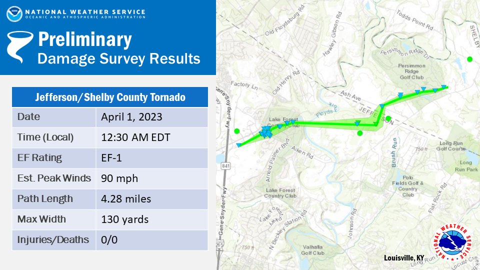
Public Information Statement
National Weather Service Louisville, KY
1001 PM EDT Mon Apr 3 2023 /901 PM CDT Mon Apr 3 2023/

...NWS Damage Survey for 04/01/2023 Tornado Event in Jefferson
and Shelby Counties in Kentucky...

.Jefferson/Shelby County EF-1...

Rating:                 EF-1
Estimated Peak Wind:    90 mph
Path Length /statute/:  4.2812 miles
Path Width /maximum/:   130.0 yards
Fatalities:             0
Injuries:               0

Start Date:             04/01/2023
Start Time:             12:30 AM EDT
Start Location:         2 NNE Middletown / Jefferson County / KY
Start Lat/Lon:          38.2696 / -85.4967

End Date:               04/01/2023
End Time:               12:34 AM EDT
End Location:           2 SE Floydsburg / Shelby County / KY
End Lat/Lon:            38.2853 / -85.4262

Survey Summary:
The National Weather Service conducted a storm assessment survey
across Eastern Jefferson County from storms early Saturday
morning just after midnight on April 1. The survey team found an
EF1 tornado with maximum winds of 90 mph. The tornado went a
little over 4 miles intermittently and crossed over into extreme
northwestern Shelby County.

The tornado first touched down just east of I-265 (Gene Snyder Freeway)
at a large warehouse by Terra View Trail. The western edge of the
warehouse was partially peeled back and insulation was thrown off
to the north through easterly directions. A portion of the tornado
was aloft, based on the lack of tree damage initially, until it
hit a plastic surgery center off of Bush Farm Road which sustained
roof damage. This consisted of shingle and fascia damage. Most of
that was cleaned up and repaired by the time of the survey.
There was insulation on the backside of the three-story building.

The street sign was bent back and turned to the northeast at
Arnold Palmer Boulevard near Chestnut Ridge. There was sporadic tree
damage along Chestnut Ridge Circle, and at 15107 Chestnut Ridge
Circle a doorbell camera showed an intense loud 20 second burst of
wind and rain. The homeowner stated that the entire house was shaking,
and several trees were snapped and twisted, and their garbage
tote was found two houses over behind that house.  Behind their
house across Lake Forest Country Club were several uprooted and
twisted trees. Most of the trees were laying from the north
northeast to due east. There was sporadic wind damage along
Champion Lakes Way, with several houses sustaining gutter and
fascia damage. The maximum wind speed in Lake Forest was 85 mph
with a width of 75 yards.

The tornado took a southward jog along Flat Rock Road and increased
in wind speed and width. All along Flat Rock Road there were dozens
and dozens of trees snapped, twisted and uprooted. The width of the
tornado increased to 130 yards wide and the wind speed increased to
90 mph. Several residents heard a distinct roar and had their ears
pop. There was shingle and fascia damage.

The tornado took a northward jog and crossed into northwestern Shelby
County. The twister did sporadic wind damage along Crabapple Lane.
Trees were snapped and twisted and some uprooted. Wind speeds were
between 80 and 85 mph and the width decreased to less than 100 yards.
The tornado crossed Kentucky Route 362 (Ash Ave) along the southern
portion of Persimmon Ridge Golf Club. The main damage was shingle loss
to homes, and sporadic tree damage.

The last damage point was along Persimmon Ridge Road, paralleling Aiken
Road.


&&

EF Scale: The Enhanced Fujita Scale classifies tornadoes into the
following categories:

EF0...Weak......65 to 85 mph
EF1...Weak......86 to 110 mph
EF2...Strong....111 to 135 mph
EF3...Strong....136 to 165 mph
EF4...Violent...166 to 200 mph
EF5...Violent...>200 mph

NOTE:
The information in this statement is preliminary and subject to
change pending final review of the event and publication in NWS
Storm Data.

$$

Gordon/Murphy


 Weather Story
 Weather Map
 Local Radar