Overview
|
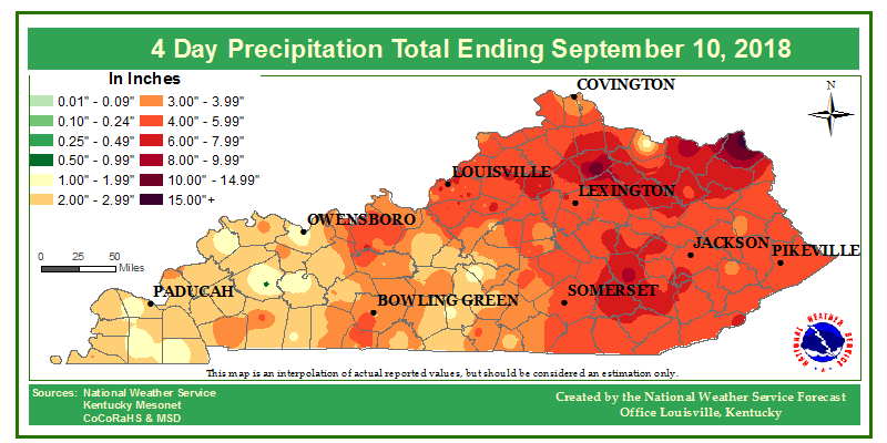
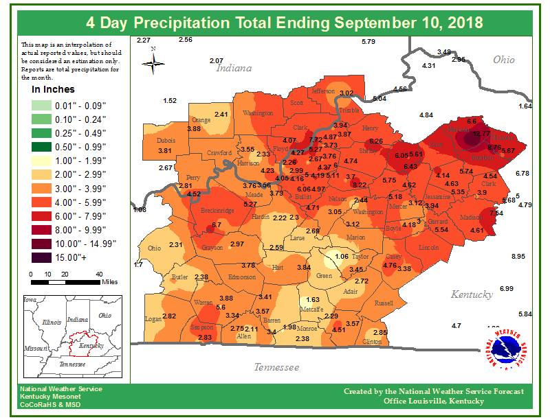
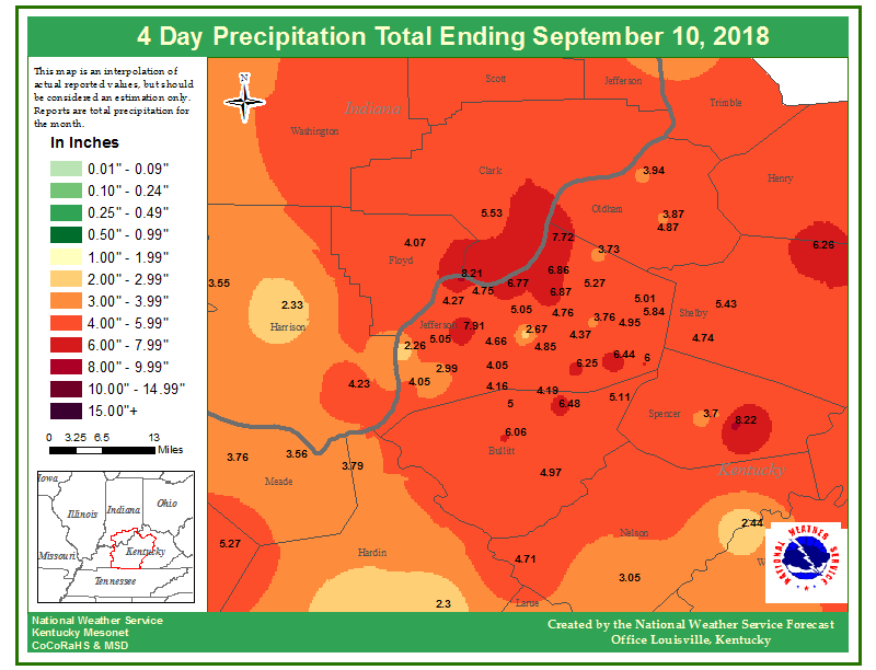
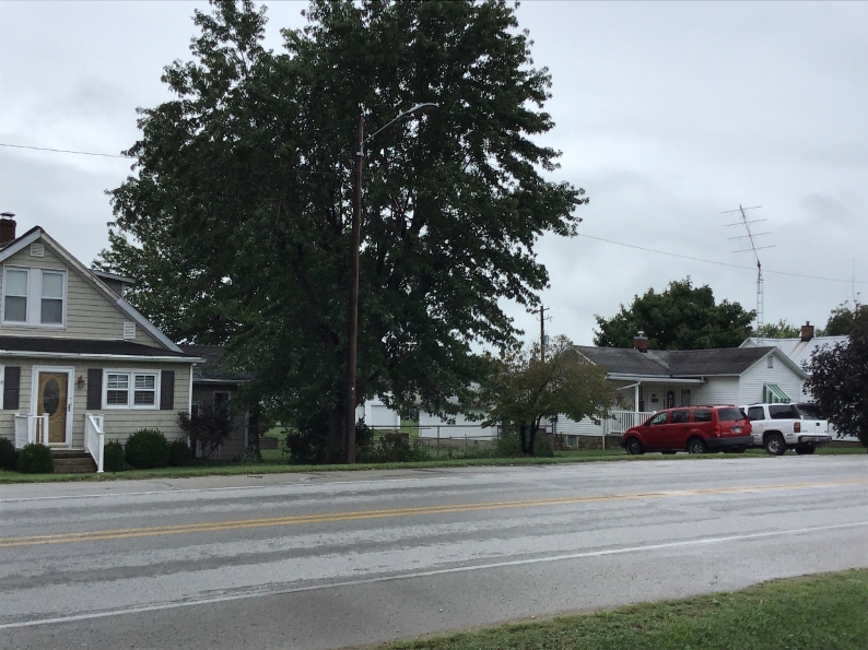
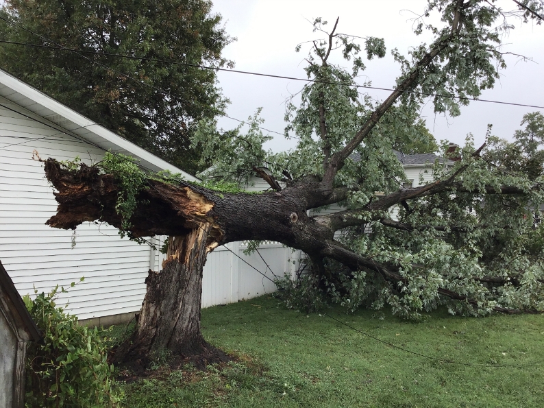
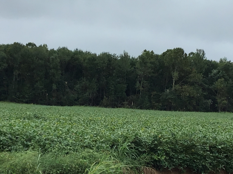
The extratropical remnants of Gordon moved slowly across the Ohio Valley on Saturday, September 8, 2018, bringing heavy rainfall and severe weather. The primary impacts across central Kentucky and southern Indiana were flash flooding and two confirmed EF-0 tornadoes. |
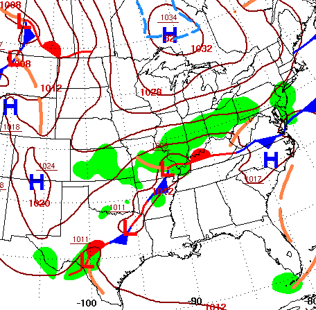 Weather map showing the low pressure center that was formerly Tropical Storm Gordon, and a stationary front across Kentucky. |
Tornadoes:
|
|
||||||||||
|
||||||||||
|
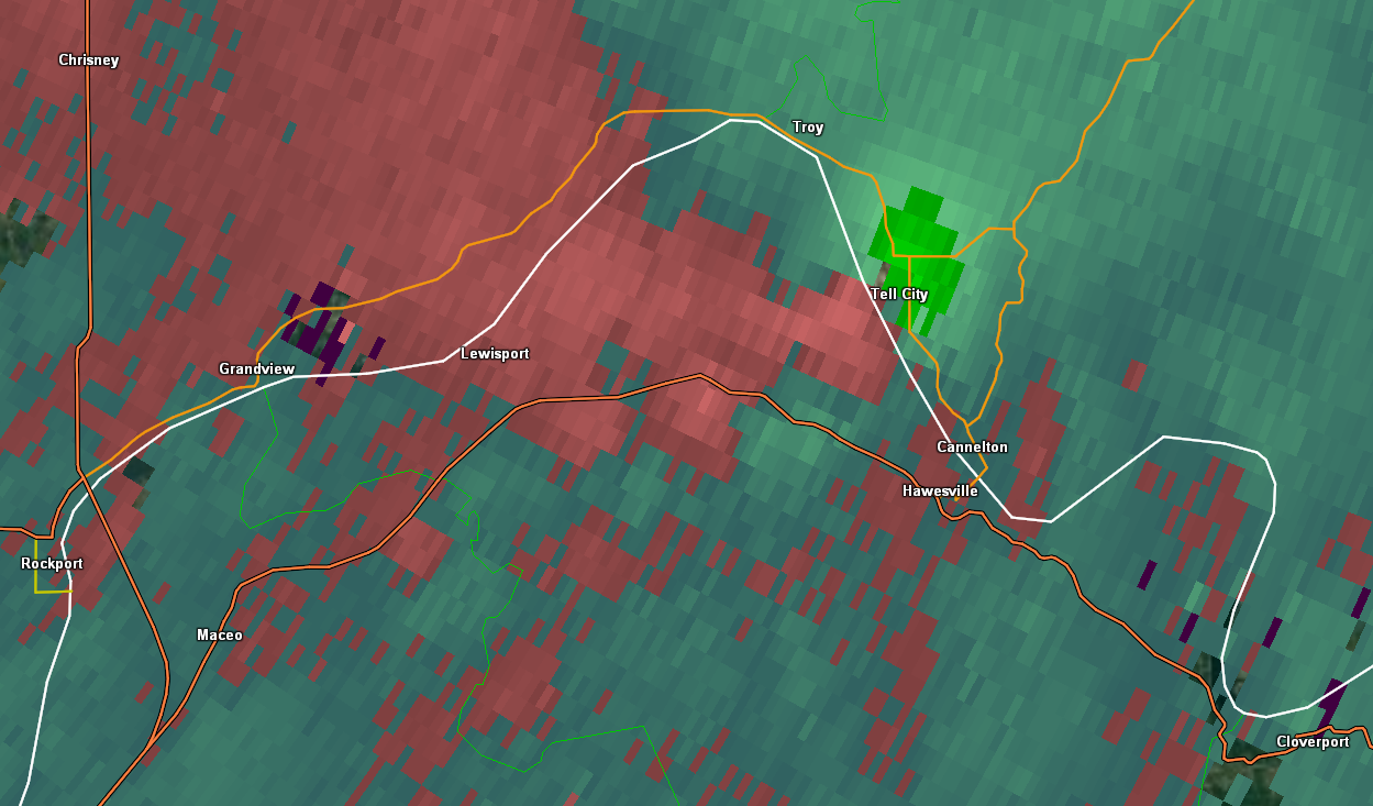
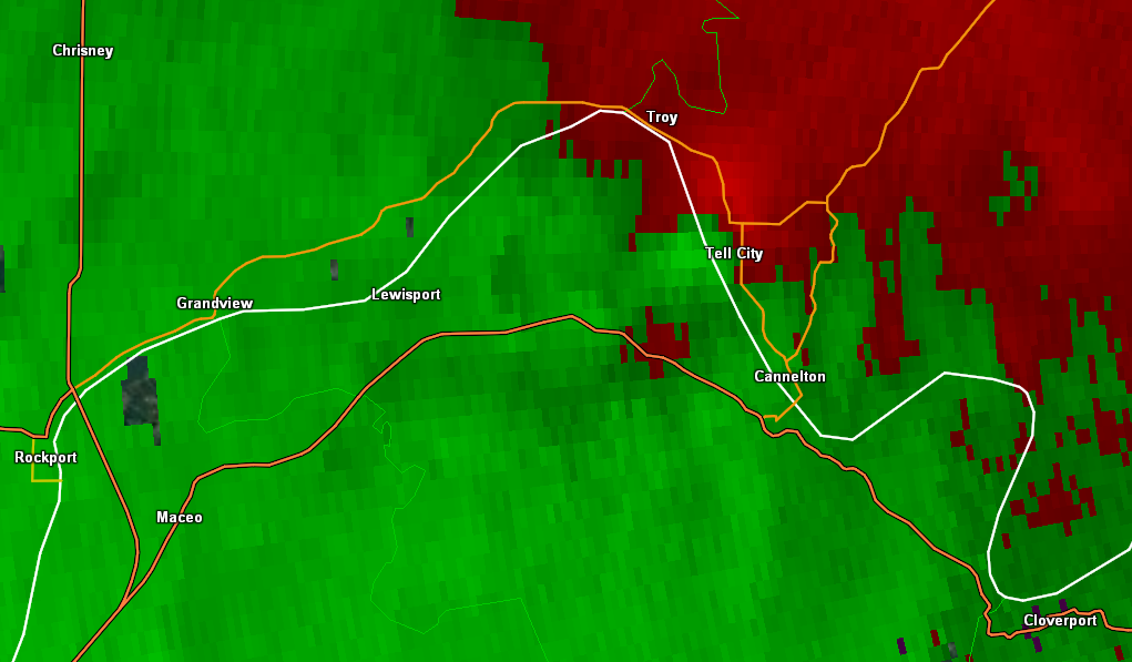
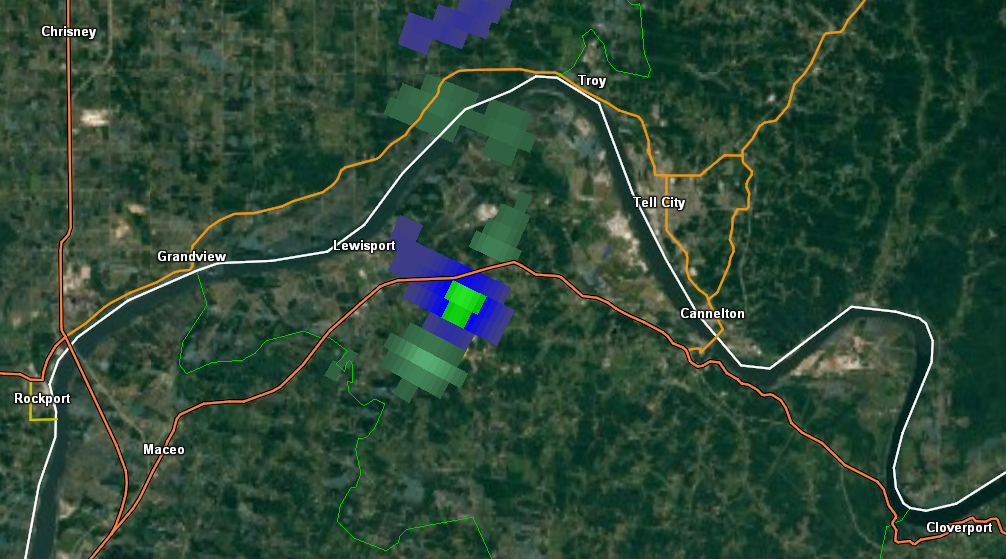
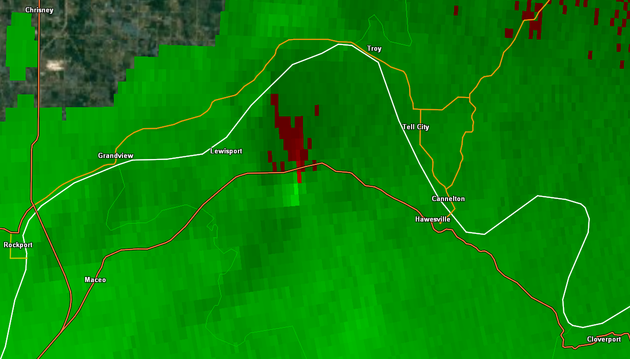
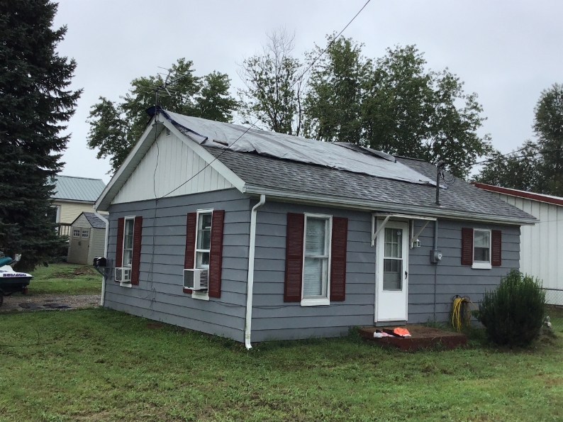
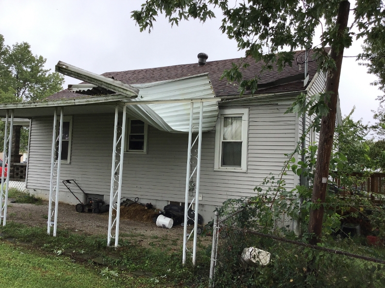
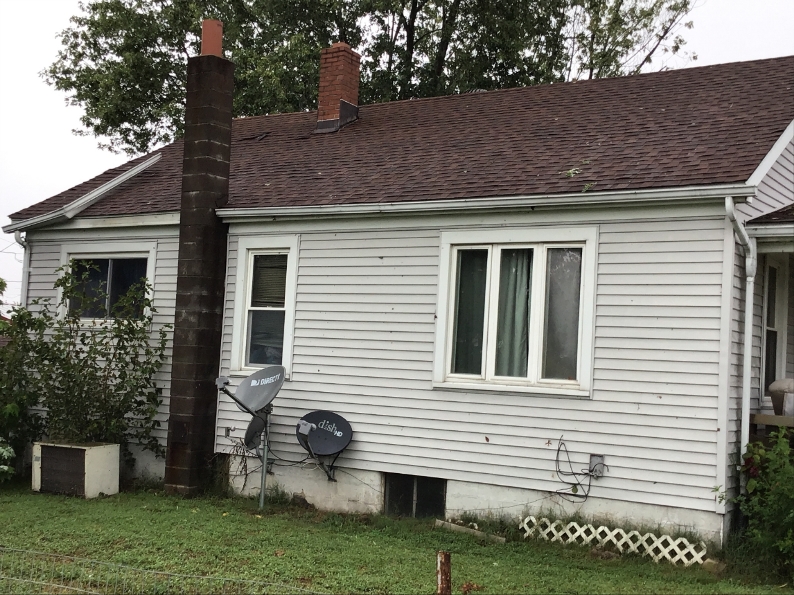
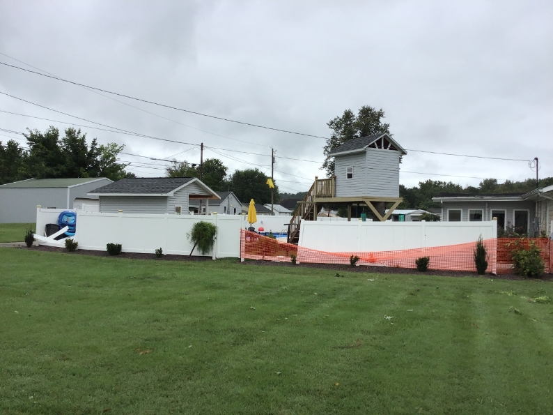
Tornado - Tell City, IN
Track Map  
Downloadable KMZ File |
||||||||||||||||||||||||||||||||
|
||||||||||||||||||||||||||||||||
|
Tornado - 3 miles SSE of Lewisport, KY
Track Map 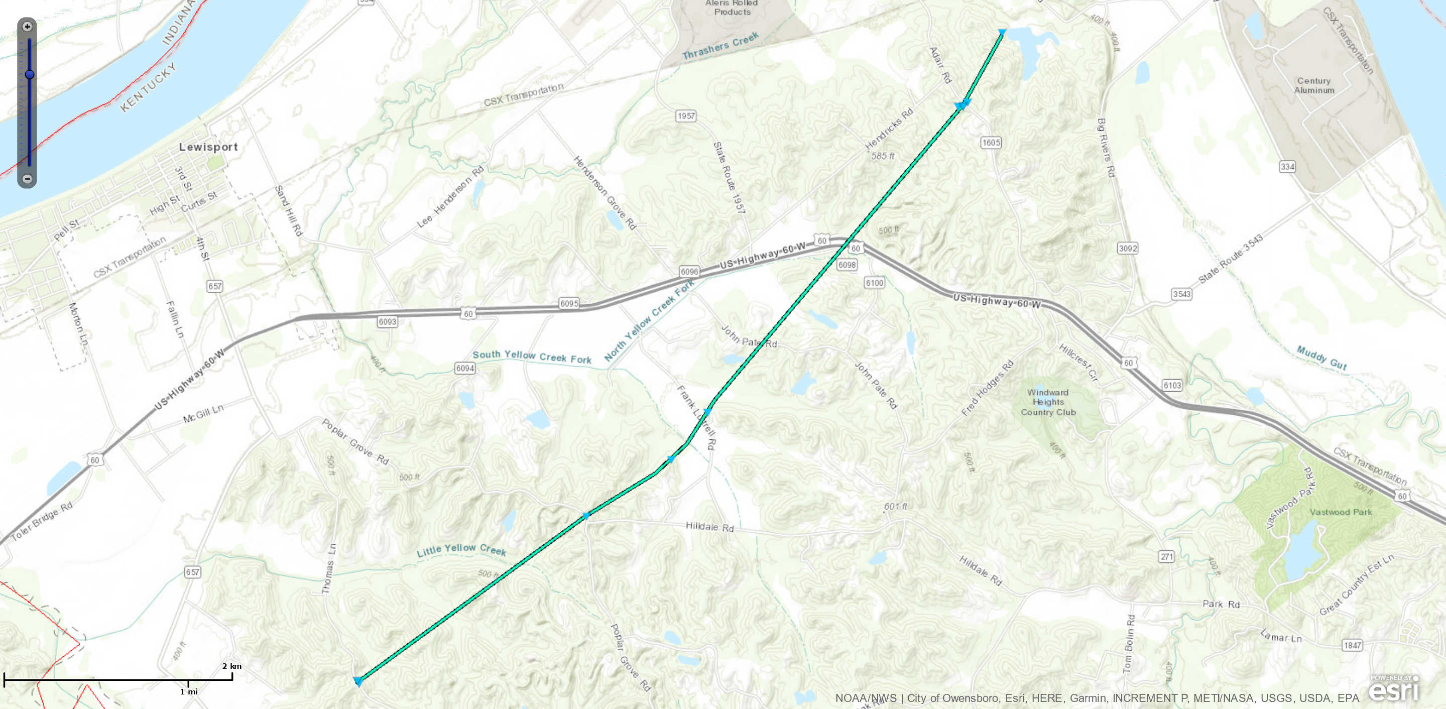
Downloadable KMZ File |
||||||||||||||||
|
||||||||||||||||
The Enhanced Fujita (EF) Scale classifies tornadoes into the following categories:
| EF0 Weak 65-85 mph |
EF1 Moderate 86-110 mph |
EF2 Significant 111-135 mph |
EF3 Severe 136-165 mph |
EF4 Extreme 166-200 mph |
EF5 Catastrophic 200+ mph |
 |
|||||
Flooding
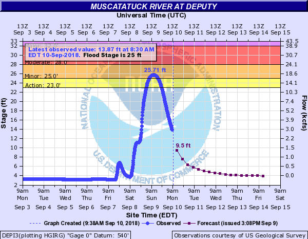
Hydrographs
 |
 |
 |
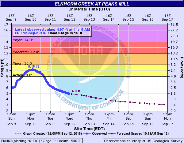 |
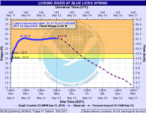
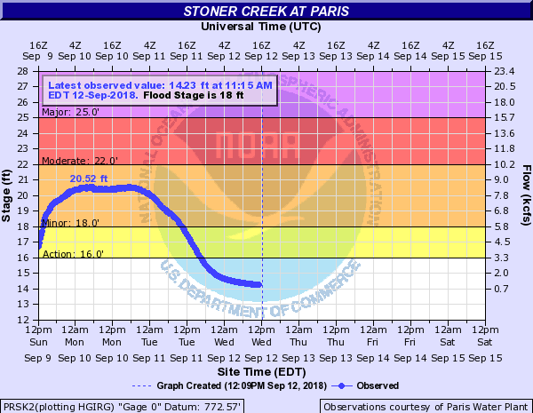
| Muscatatuck River at Deputy, Indiana | Licking River at Blue Licks Spring, Kentucky | Stoner Creek at Paris, Kentucky | Elkhorn Creek at Peaks Mill, Kentucky |
Radar:
Header
 |
 |
 |
 |
| Storm relative velocity data from NWS radar near Evansville. The bright green and pink colors next to each other suggest rotation over Tell City. An EF0 tornado was confirmed in this location. | Velocity data from NWS radar at Fort Knox. The green and red colors next to each other suggest rotation over Tell City. An EF0 tornado was confirmed in this location. | Data from NWS radar near Evansville that depict rotation. The bright green color is a hallmark of significant rotational velocities over northern Hancock County. An EF0 tornado was confirmed in this location. | Velocity data from NWS radar at Fort Knox. The green and red colors next to each other suggest rotation over northern Hancock County. An EF0 tornado was confirmed in this location. |
Storm Reports
Severe Weather reports:
PRELIMINARY LOCAL STORM REPORT...SUMMARY
NATIONAL WEATHER SERVICE LOUISVILLE KY
1156 AM EDT MON SEP 10 2018
..TIME... ...EVENT... ...CITY LOCATION... ...LAT.LON...
..DATE... ....MAG.... ..COUNTY LOCATION..ST.. ...SOURCE....
..REMARKS..
0855 PM TSTM WND DMG 2 NNW HILLVIEW 38.10N 85.70W
09/08/2018 JEFFERSON KY TRAINED SPOTTER
TREES DOWN ON THE 10200 BLOCK OF BLUE LICK
ROAD.
0600 PM TSTM WND DMG 3 NNW TELL CITY 37.99N 86.78W
09/08/2018 PERRY IN LAW ENFORCEMENT
TREES DOWN BETWEEN TELL CITY AND TROY.
0554 PM TSTM WND DMG 1 WNW LEAVENWORTH 38.21N 86.36W
09/08/2018 CRAWFORD IN PUBLIC
CORRECTS PREVIOUS TSTM WND DMG REPORT FROM 1
WNW LEAVENWORTH. TREE DOWN ON HIGHWAY 62.
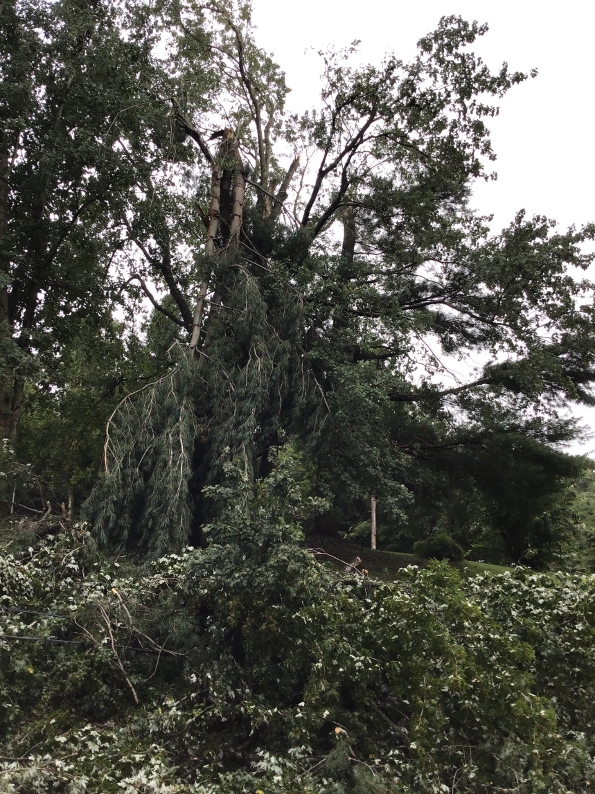
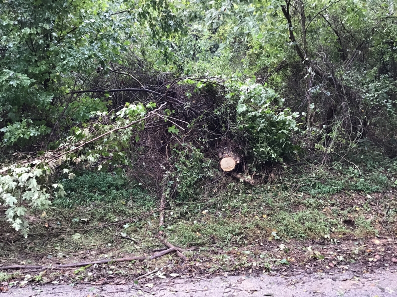
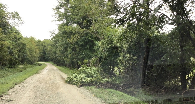
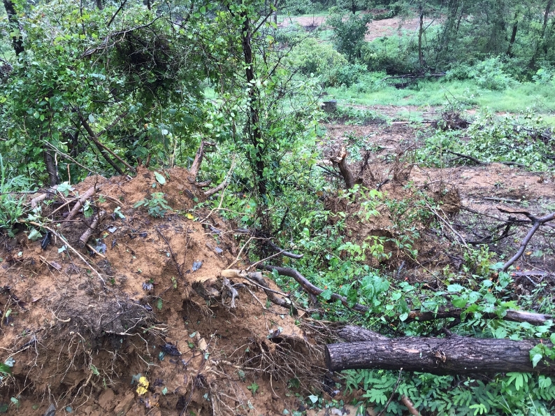
0542 PM TORNADO 3 SSE LEWISPORT 37.90N 86.88W
09/08/2018 HANCOCK KY NWS STORM SURVEY
THIS EF-0 TORNADO WAS ON THE GROUND FOR
APPROXIMATELY 12 MINUTES WITH A PATH LENGTH
OF 5 MILES AND MAXIMUM WIDTH OF 50 YARDS.
PEAK WIND SPEEDS WERE ESTIMATED AT 75-80
MPH. MOST DAMAGE WAS DONE 20-30 FEET ABOVE
GROUND, WHERE IT SNAPPED SEVERAL TREES AND
BRANCHES AND CAUSED MINOR DAMAGE TO THE
METAL ROOF OF A BARN. LATER AS THE TORNADO
TRAVELED NORTHEAST IT UPROOTED AND SNAPPED A
FEW TREES. RESIDENTS OF THE AREA THEN
WITNESSED THE TORNADO DISSIPATING INTO A
WOODED AREA.
0504 PM TSTM WND DMG 1 WNW NEW SALISBURY 38.32N 86.12W
09/08/2018 HARRISON IN DEPT OF HIGHWAYS
TREE DOWN ALONG MAYDEN TRAIL BETWEEN WHISKEY
RUN ROAD AND SR 64.
0456 PM TSTM WND DMG 2 N DOGWOOD 38.13N 86.08W
09/08/2018 HARRISON IN DEPT OF HIGHWAYS
TREE DOWN ACROSS LAKE ROAD.
0445 PM FUNNEL CLOUD 5 N BATTLETOWN 38.14N 86.30W
09/08/2018 MEADE KY TRAINED SPOTTER
0427 PM TSTM WND DMG SULPHUR 38.23N 86.47W
09/08/2018 CRAWFORD IN TRAINED SPOTTER
TREE DOWNED ON A POWER LINE.
0420 PM TSTM WND DMG 2 WNW ANDYVILLE 38.04N 86.40W
09/08/2018 MEADE KY LAW ENFORCEMENT
POWER LINE DOWN NEAR CONCORDIA.
0414 PM TSTM WND DMG 1 E LEOPOLD 38.10N 86.57W
09/08/2018 PERRY IN BROADCAST MEDIA
TREES DOWN.
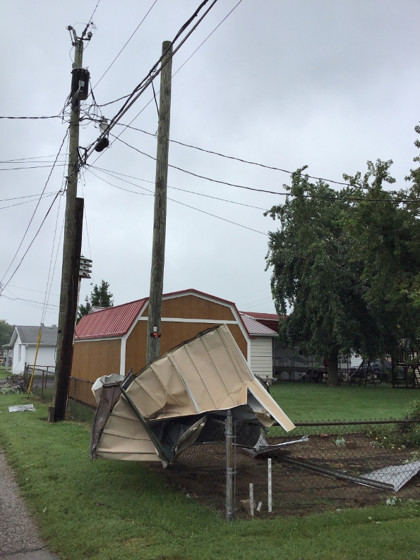
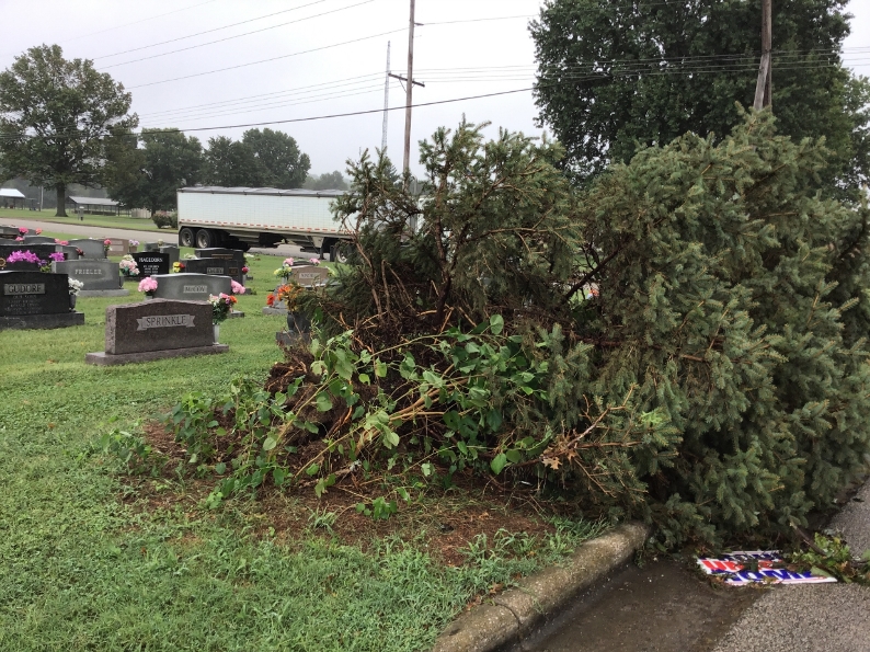
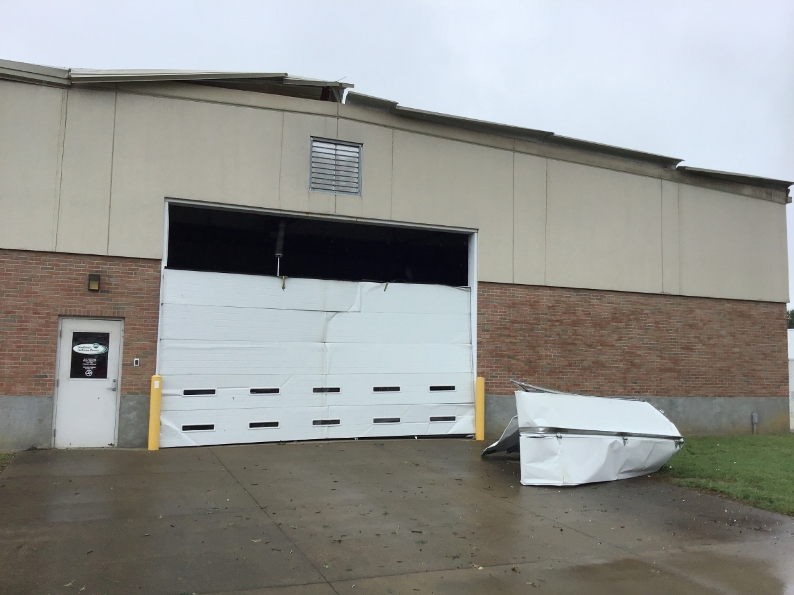
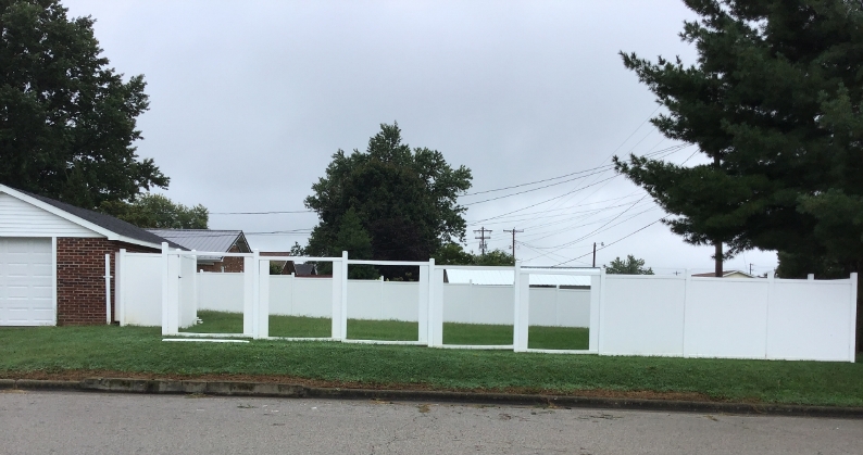
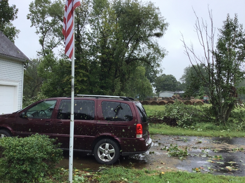
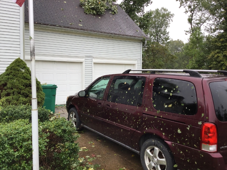
0350 PM TSTM WND DMG 3 NE TELL CITY 37.98N 86.73W
09/08/2018 PERRY IN TRAINED SPOTTER
GARAGE DOOR AND ROOF DAMAGE TO A WAREHOUSE
TYPE BUILDING ON THE NORTH SIDE OF TELL
CITY. SEVERAL FENCES AND LARGE TREES DOWN.
ALSO STREET FLOODING IN TELL CITY.
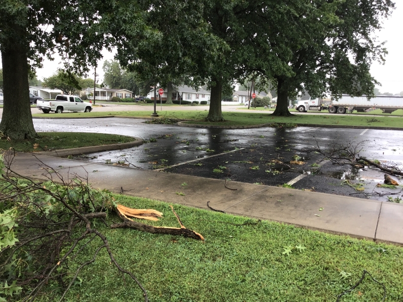
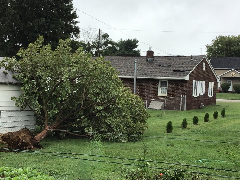
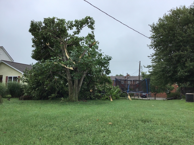
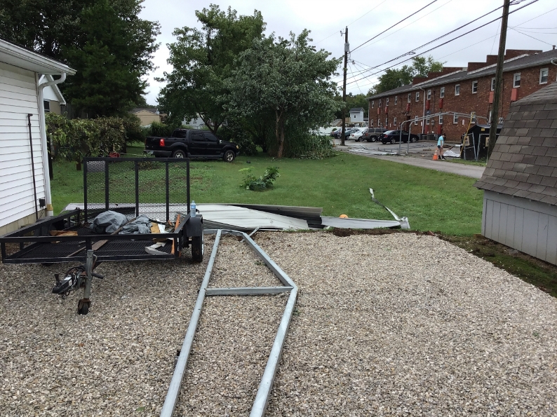
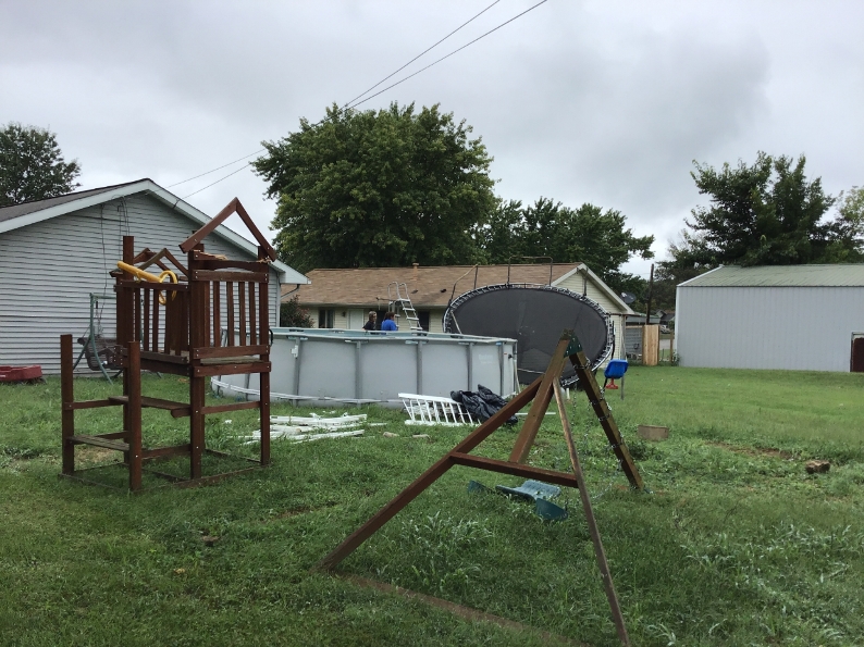
0338 PM TORNADO 1 NNW TELL CITY 37.97N 86.77W
09/08/2018 PERRY IN NWS STORM SURVEY
THIS EF-0 TORNADO WAS ON THE GROUND FOR 6
MINUTES AND TRAVELED NORTHEAST FROM TELL
CITY. THE TORNADO WAS ON THE GROUND FOR 1.75
MILES WITH A MAXIMUM WIDTH OF 80 YARDS AND
PEAK WINDS ESTIMATED AT 70-80 MPH. IT
TOUCHED DOWN ON MAIN STREET, DOING MINOR
ROOF DAMAGE AND BENDING AN AMATEUR RADIO
TOUR. MORE ROOFS WERE DAMAGED ALONG WITH
LARGE TREE LIMBS. ONE ROTTED TROUGH WAS
TOPPLED, FALLING ONTO THE ROOF OF A GARAGE.
IT CONTINUED CAUSING SOME MINOR STRUCTURE
DAMAGE, INCLUDING LIFTING A SHED AND A
CARPORT. AS IT MOVED INTO A MORE RURAL AREA
IT CONTINUED TO CAUSE TREE DAMAGE, SNAPPING
TRUNKS OF THREE LARGE TREES.
0247 PM TSTM WND GST 1 S WACO 37.72N 84.15W
09/08/2018 M50 MPH MADISON KY MESONET
CORRECTION OF TIME OF EVENT.
Flooding reports:
PRELIMINARY LOCAL STORM REPORT...SUMMARY
NATIONAL WEATHER SERVICE LOUISVILLE KY
1207 PM EDT MON SEP 10 2018
..TIME... ...EVENT... ...CITY LOCATION... ...LAT.LON...
..DATE... ....MAG.... ..COUNTY LOCATION..ST.. ...SOURCE....
..REMARKS..
0624 AM HEAVY RAIN 5 S LEXINGTON 37.97N 84.52W
09/10/2018 M5.69 INCH FAYETTE KY COCORAHS
2-DAY RAINFALL TOTAL AT STATION KY-FY-29.
0615 AM HEAVY RAIN 1 E PARIS 38.20N 84.24W
09/10/2018 M3.99 INCH BOURBON KY CO-OP OBSERVER
2 DAYS WORTH OF RAIN REPORTS FROM THE PARIS
WATER TREATMENT PLANT.
0500 AM HEAVY RAIN 5 NE KEENE 37.98N 84.55W
09/10/2018 M4.96 INCH FAYETTE KY COCORAHS
ALMOST 36 HOUR RAINFALL TOTAL BASED ON TWO
DAYS OF REPORTS.
1200 AM HEAVY RAIN 1 ENE HARDYVILLE 37.26N 85.78W
09/10/2018 M2.35 INCH HART KY MESONET
24-HOUR RAINFALL TOTAL AT HART COUNTY
KENTUCKY MESONET STATION.
1200 AM HEAVY RAIN 8 SE LEXINGTON 37.97N 84.38W
09/10/2018 M4.82 INCH FAYETTE KY PUBLIC
24-HOUR RAINFALL TOTAL MEASURED AT PRIVATE
WEATHER STATION.
1200 AM HEAVY RAIN 3 S FRANKLIN 36.68N 86.57W
09/10/2018 M2.56 INCH SIMPSON KY PUBLIC
24-HOUR RAINFALL TOTAL MEASURED AT PRIVATE
WEATHER STATION.
1200 AM HEAVY RAIN 1 SW PARIS 38.19N 84.28W
09/10/2018 M2.65 INCH BOURBON KY PUBLIC
24-HOUR RAINFALL TOTAL MEASURED AT PRIVATE
WEATHER STATION.
1200 AM HEAVY RAIN 2 NNE SCOTTSVILLE 36.77N 86.18W
09/10/2018 M2.04 INCH ALLEN KY PUBLIC
24-HOUR RAINFALL TOTAL MEASURED AT PRIVATE
WEATHER STATION.
1200 AM HEAVY RAIN 3 ESE MILLERSBURG 38.28N 84.10W
09/10/2018 M2.37 INCH NICHOLAS KY MESONET
24-HOUR RAINFALL TOTAL AT NICHOLAS COUNTY
KENTUCKY MESONET STATION.
1200 AM HEAVY RAIN 6 SSW LEXINGTON 37.97N 84.53W
09/10/2018 M2.71 INCH FAYETTE KY MESONET
24-HOUR RAINFALL TOTAL AT FAYETTE COUNTY
KENTUCKY MESONET STATION.
1200 AM HEAVY RAIN RUCKERVILLE 37.94N 84.10W
09/10/2018 M4.28 INCH CLARK KY PUBLIC
24-HOUR RAINFALL TOTAL MEASURED AT PRIVATE
WEATHER STATION.
1200 AM HEAVY RAIN 1 SSW WILMORE 37.85N 84.67W
09/10/2018 M3.07 INCH JESSAMINE KY PUBLIC
24-HOUR RAINFALL TOTAL MEASURED AT PRIVATE
WEATHER STATION.
1200 AM HEAVY RAIN 3 WSW LEBANON 37.55N 85.30W
09/10/2018 M2.04 INCH MARION KY PUBLIC
24-HOUR RAINFALL TOTAL MEASURED AT PRIVATE
WEATHER STATION.
1200 AM HEAVY RAIN 3 E KEENE 37.94N 84.58W
09/10/2018 M3.91 INCH JESSAMINE KY PUBLIC
24-HOUR RAINFALL TOTAL MEASURED AT PRIVATE
WEATHER STATION.
1200 AM HEAVY RAIN 1 WSW HARRODSBURG 37.76N 84.87W
09/10/2018 M2.91 INCH MERCER KY PUBLIC
24-HOUR RAINFALL TOTAL MEASURED AT PRIVATE
WEATHER STATION.
1200 AM HEAVY RAIN 2 ESE SHAKERTOWN 37.81N 84.84W
09/10/2018 M2.72 INCH MERCER KY MESONET
24-HOUR RAINFALL TOTAL AT MERCER COUNTY
KENTUCKY MESONET STATION.
1200 AM HEAVY RAIN 6 NNW SPEARS 37.95N 84.48W
09/10/2018 M4.61 INCH FAYETTE KY PUBLIC
24-HOUR RAINFALL TOTAL MEASURED AT PRIVATE
WEATHER STATION.
1200 AM HEAVY RAIN 3 NNW WINCHESTER 38.03N 84.21W
09/10/2018 M2.89 INCH CLARK KY MESONET
24-HOUR RAINFALL TOTAL AT CLARK COUNTY
KENTUCKY MESONET STATION.
1200 AM HEAVY RAIN 4 WNW REDHOUSE 37.86N 84.33W
09/10/2018 M4.91 INCH MADISON KY PUBLIC
24-HOUR RAINFALL TOTAL MEASURED AT PRIVATE
WEATHER STATION.
1200 AM HEAVY RAIN 2 E PERRYVILLE 37.65N 84.92W
09/10/2018 M2.13 INCH BOYLE KY PUBLIC
24-HOUR RAINFALL TOTAL MEASURED AT PRIVATE
WEATHER STATION.
0740 PM HEAVY RAIN 4 NNW MYERS 38.40N 83.98W
09/09/2018 M6.30 INCH NICHOLAS KY PUBLIC
48-HOUR RAINFALL TOTAL. ALSO REPORT OF LOCAL
FLOODING ON STONEY CREEK.
0341 PM FLASH FLOOD 3 W SPEARS 37.86N 84.51W
09/09/2018 JESSAMINE KY EMERGENCY MNGR
FLOWING WATER OVER BETHANY RD IN THE LOGANA
AREA.
0341 PM FLASH FLOOD 4 NW SPEARS 37.91N 84.50W
09/09/2018 JESSAMINE KY EMERGENCY MNGR
MACKEY PIKE NEAR HICKMAN CREEK HAS A COUPLE
FEET OF WATER FLOWING ACROSS IT IN PLACES.
THE ROAD IS CLOSED.
1048 AM FLOOD 3 NW RUCKERVILLE 37.97N 84.14W
09/09/2018 CLARK KY BROADCAST MEDIA
SOCIAL MEDIA VIDEO FROM BROADCAST MEDIA
SHOWS LARGE AMOUNT OF FLOODING ALONG IRVINE
ROAD SOUTHEAST OF WINCHESTER.
0815 AM FLASH FLOOD 3 NW RUCKERVILLE 37.97N 84.13W
09/09/2018 CLARK KY 911 CALL CENTER
STATE ROAD 89, IRVINE RD, UNDERWATER IN A 1
TO 2 MILE SECTION SOUTHEAST OF WINCHESTER,
KY.
0644 AM HEAVY RAIN LEAVENWORTH 38.20N 86.35W
09/09/2018 M6.88 INCH CRAWFORD IN CO-OP OBSERVER
24-HOUR RAINFALL TOTAL.
0644 AM HEAVY RAIN BEECHWOOD 38.20N 86.42W
09/09/2018 M5.81 INCH CRAWFORD IN CO-OP OBSERVER
24-HOUR RAINFALL TOTAL.
0600 AM HEAVY RAIN 2 W FLOYDS KNOBS 38.32N 85.90W
09/09/2018 M4.07 INCH FLOYD IN COCORAHS
24-HOUR RAINFALL TOTAL.
0600 AM HEAVY RAIN 1 ESE CORYDON 38.21N 86.11W
09/09/2018 M4.48 INCH HARRISON IN COCORAHS
24-HOUR RAINFALL TOTAL.
0530 AM HEAVY RAIN WATSON 38.35N 85.70W
09/09/2018 M5.55 INCH CLARK IN COCORAHS
24-HOUR RAINFALL TOTAL.
0519 AM HEAVY RAIN 1 SW PEWEE VALLEY 38.30N 85.50W
09/09/2018 M3.01 INCH JEFFERSON KY COCORAHS
24-HOUR RAINFALL TOTAL.
0500 AM HEAVY RAIN 2 SSW BUCKNER 38.36N 85.45W
09/09/2018 M3.26 INCH OLDHAM KY COCORAHS
24-HOUR RAINFALL TOTAL.
1245 AM HEAVY RAIN 2 SE LYNDON 38.25N 85.56W
09/09/2018 M3.99 INCH JEFFERSON KY NWS EMPLOYEE
STORM TOTAL RAINFALL. 3.35 INCHES OF RAIN
SINCE 4 PM SATURDAY.
1200 AM HEAVY RAIN 1 S SCHNELLVILLE 38.31N 86.75W
09/09/2018 M5.41 INCH DUBOIS IN PUBLIC
24-HOUR RAINFALL TOTAL ENDING MEASURED AT
PRIVATE WEATHER STATION.
1200 AM HEAVY RAIN CRANDALL 38.29N 86.07W
09/09/2018 M6.43 INCH HARRISON IN PUBLIC
24-HOUR TOTAL MEASURED AT PRIVATE WEATHER
STATION.
1200 AM HEAVY RAIN 4 E LEESBURG 38.29N 84.34W
09/09/2018 M3.47 INCH HARRISON KY PUBLIC
24-HOUR RAINFALL TOTAL MEASURED AT PRIVATE
WEATHER STATION.
1200 AM HEAVY RAIN 1 N SALEM 38.62N 86.10W
09/09/2018 M4.21 INCH WASHINGTON IN PUBLIC
24-HOUR RAINFALL TOTAL MEASURED AT PRIVATE
WEATHER STATION.
1200 AM HEAVY RAIN 2 NNE NEWTOWN 38.24N 84.46W
09/09/2018 M2.06 INCH SCOTT KY PUBLIC
24-HOUR RAINFALL TOTAL MEASURED AT PRIVATE
WEATHER STATION.
1200 AM HEAVY RAIN 3 WSW KENT 38.72N 85.59W
09/09/2018 M3.38 INCH JEFFERSON IN PUBLIC
24-HOUR RAINFALL TOTAL MEASURED AT PRIVATE
WEATHER STATION.
1200 AM HEAVY RAIN GOSHEN 38.41N 85.59W
09/09/2018 M5.56 INCH OLDHAM KY PUBLIC
24-HOUR RAINFALL MEASURED AT PRIVATE WEATHER
STATION.
1200 AM HEAVY RAIN 1 S WACO 37.72N 84.15W
09/09/2018 M2.16 INCH MADISON KY MESONET
24-HOUR RAINFALL TOTAL MEASURED AT THE
MADISON COUNTY KENTUCKY MESONET STATION.
1200 AM HEAVY RAIN 4 NE BEDFORD 38.64N 85.27W
09/09/2018 M4.46 INCH TRIMBLE KY PUBLIC
24-HOUR RAINFALL TOTAL MEASURED AT A PRIVATE
WEATHER STATION.
1200 AM HEAVY RAIN 2 SE BERRY 38.50N 84.35W
09/09/2018 M2.31 INCH HARRISON KY MESONET
24-HOUR RAINFALL TOTAL MEASURED AT THE
HARRISON COUNTY KENTUCKY MESONET STATION.
1200 AM HEAVY RAIN 1 SSW APALONA 38.14N 86.64W
09/09/2018 M5.67 INCH PERRY IN PARK/FOREST SRVC
24-HOUR TOTAL MEASURED AT TIPSAW LAKE RAWS.
1200 AM HEAVY RAIN 1 SSE SHIVELY 38.18N 85.81W
09/09/2018 M6.34 INCH JEFFERSON KY MESONET
24-HOUR RAINFALL MEASURED AT THE WHEELER
BASIN LOUISVILLE MSD RAIN GAUGE.
1200 AM HEAVY RAIN MARENGO 38.38N 86.34W
09/09/2018 M5.94 INCH CRAWFORD IN OTHER FEDERAL
24-HOUR RAINFALL TOTAL MEASURED AT WHISKEY
RUN HADS SITE.
1200 AM HEAVY RAIN 3 E KEENE 37.94N 84.58W
09/09/2018 M2.95 INCH JESSAMINE KY PUBLIC
24-HOUR RAINFALL TOTAL MEASURED AT PRIVATE
WEATHER STATION.
1200 AM HEAVY RAIN 2 S EMINENCE 38.33N 85.17W
09/09/2018 M2.70 INCH SHELBY KY MESONET
24-HOUR RAINFALL TOTAL MEASURED AT THE
NORTHERN SHELBY COUNTY KENTUCKY MESONET
STATION.
1200 AM HEAVY RAIN 2 E SELLERSBURG 38.39N 85.72W
09/09/2018 M7.72 INCH CLARK IN PUBLIC
24-HOUR RAINFALL TOTAL MEASURED AT PRIVATE
WEATHER STATION.
1200 AM HEAVY RAIN 3 SSW ORLEANS 38.62N 86.48W
09/09/2018 M5.13 INCH ORANGE IN PUBLIC
24-HOUR RAINFALL TOTAL MEASURED AT PRIVATE
WEATHER STATION.
1200 AM HEAVY RAIN BETHLEHEM 38.40N 85.06W
09/09/2018 M3.06 INCH HENRY KY PUBLIC
24-HOUR RAINFALL TOTAL MEASURED AT PRIVATE
WEATHER STATION.
1200 AM HEAVY RAIN 2 S WESTPORT 38.46N 85.47W
09/09/2018 M4.02 INCH OLDHAM KY MESONET
MEASURED AT OLDHAM COUNTY KENTUCKY MESONET
STATION LGRN.
1200 AM HEAVY RAIN 2 WSW PROSPECT 38.34N 85.64W
09/09/2018 M6.70 INCH JEFFERSON KY MESONET
24-HOUR RAINFALL TOTAL MEASURED AT THE
TRANSYLVANIA BEACH LOUISVILLE MSD RAIN
GAUGE.
1200 AM HEAVY RAIN 2 E GEORGETOWN 38.30N 85.94W
09/09/2018 M5.40 INCH FLOYD IN PUBLIC
24-HOUR RAINFALL TOTAL MEASURED AT PRIVATE
WEATHER STATION.
1200 AM HEAVY RAIN 3 SSW CHARLESTOWN 38.42N 85.68W
09/09/2018 M6.79 INCH CLARK IN PUBLIC
24-HOUR RAINFALL TOTAL MEASURED AT PRIVATE
WEATHER STATION.
1200 AM HEAVY RAIN 8 SE LEXINGTON 37.97N 84.38W
09/09/2018 M2.64 INCH FAYETTE KY PUBLIC
24-HOUR RAINFALL TOTAL MEASURED AT A PRIVATE
WEATHER STATION.
1200 AM HEAVY RAIN 6 SSW LEXINGTON 37.97N 84.53W
09/09/2018 M2.42 INCH FAYETTE KY MESONET
24-HOUR RAINFALL TOTAL MEASURED AT THE
FAYETTE COUNTY KENTUCKY MESONET STATION.
1200 AM HEAVY RAIN 1 SE LEWISPORT 37.92N 86.89W
09/09/2018 M4.86 INCH HANCOCK KY PUBLIC
24-HOUR TOTAL MEASURED AT PRIVATE WEATHER
STATION.
1200 AM HEAVY RAIN 4 NW TELL CITY 37.99N 86.80W
09/09/2018 M5.76 INCH PERRY IN PUBLIC
24-HOUR RAINFALL TOTAL MEASURED AT PRIVATE
WEATHER STATION.
1200 AM HEAVY RAIN 3 SW VALLEY STATION 38.08N 85.90W
09/09/2018 M6.62 INCH JEFFERSON KY MESONET
24-HR RAINFALL MEASURED AT THE DR GUTHRIE
WQTC LOUISVILLE MSD RAIN GAUGE.
1015 PM HEAVY RAIN 1 N MCKINLEY 38.76N 86.20W
09/08/2018 M3.11 INCH WASHINGTON IN PUBLIC
TOTAL RAINFALL PAST 14 HOURS.
0945 PM HEAVY RAIN 4 E SHIVELY 38.19N 85.75W
09/08/2018 M3.02 INCH JEFFERSON KY ASOS
TOTAL DAILY RAINFALL SO FAR AT ASOS STATION
SDF, LOUISVILLE INTERNATIONAL.
0910 PM FLASH FLOOD 2 WSW LOUISVILLE 38.25N 85.79W
09/08/2018 JEFFERSON KY BROADCAST MEDIA
WATER RESCUE.
0905 PM FLASH FLOOD 2 NNE SHIVELY 38.22N 85.79W
09/08/2018 JEFFERSON KY BROADCAST MEDIA
SEVERAL VEHICLES UNDER WATER DIXIE HIGHWAY
AND ALGONQUIN PARKWAY.
0905 PM HEAVY RAIN 1 SE SHIVELY 38.19N 85.80W
09/08/2018 M4.93 INCH JEFFERSON KY MESONET
TOTAL RAINFALL SINCE MIDNIGHT.
0905 PM FLASH FLOOD 1 SW LOUISVILLE 38.24N 85.78W
09/08/2018 JEFFERSON KY PUBLIC
15TH STREET AND BRECKINRIDGE STREET, A DRIVE
AND TWO CHILDREN STUCK IN A VEHICLE.
0900 PM HEAVY RAIN WATSON 38.35N 85.70W
09/08/2018 M1.00 INCH CLARK IN PUBLIC
ONE INCH FELL BETWEEN 830 AND 9 PM.
0900 PM FLASH FLOOD 3 S LOUISVILLE 38.21N 85.75W
09/08/2018 JEFFERSON KY PUBLIC
CARS TRAPPED IN HIGH WATER ON THE RAMP FROM
CRITTENDEN DRIVE TO INTERSTATE 65 SOUTH.
0900 PM FLASH FLOOD 1 S VALLEY STATION 38.09N 85.86W
09/08/2018 JEFFERSON KY BROADCAST MEDIA
PERSON STUCK IN A VEHICLE ON GRAFTON HALL
ROAD. WATER RESCUE.
0857 PM FLASH FLOOD 2 SW LOUISVILLE 38.24N 85.78W
09/08/2018 JEFFERSON KY BROADCAST MEDIA
PERSON TRAPPED IN A VEHICLE AT 17TH STREET
AND DUMESNIL STREET.
0857 PM FLASH FLOOD 1 SSW LOUISVILLE 38.24N 85.78W
09/08/2018 JEFFERSON KY BROADCAST MEDIA
*** 1 FATAL ***
UPDATED REPORT FROM EARLIER. A MALE DRIVER
OF A YELLOW CAB WAS TRAVELING WESTBOUND
TOWARDS A RAILROAD UNDERPASS AT 13TH AND OAK
STREETS. AFTER ENTERING THE WATER, THE
VEHICLE HE WAS DRIVING, STOPPED MOVING
FORWARD AND THE ENGINE STOPPED. THE DRIVER
WAS UNABLE TO GET OUT OF THE VEHICLE. BY THE
TIME EMERGENCY CREWS ARRIVED, THE VEHICLE
WAS FULLY SUBMERGED. THE MAN WAS REMOVED
FROM THE VEHICLE AND PRONOUNCED DEAD AT THE
SCENE.
0855 PM FLASH FLOOD 2 WNW LOUISVILLE 38.27N 85.80W
09/08/2018 JEFFERSON KY BROADCAST MEDIA
29TH STREET FLOODED BETWEEN ST. XAVIER ST.
AND BANK ST.
0855 PM FLASH FLOOD 2 SW LOUISVILLE 38.24N 85.79W
09/08/2018 JEFFERSON KY BROADCAST MEDIA
PERSON TRAPPED IN A VEHICLE AT DIXIE HIGHWAY
AND OAK STREET. WATER RESCUE ONGOING.
0845 PM FLASH FLOOD 1 E SIBERIA 38.24N 86.71W
09/08/2018 PERRY IN DEPT OF HIGHWAYS
SR 145 IS CLOSED DUE TO HIGH WATER FROM
INTERSTATE 64, NORTH TO IN 64 IN DUBOIS
COUNTY.
0845 PM FLASH FLOOD 2 S BIRDSEYE 38.28N 86.69W
09/08/2018 DUBOIS IN DEPT OF HIGHWAYS
SR 145 IS CLOSED DUE TO HIGH WATER FROM
INTERSTATE 64 IN PERRY COUNTY, NORTH TO IN
64 AROUND BIRDSEYE.
0815 PM FLASH FLOOD CORYDON 38.21N 86.13W
09/08/2018 HARRISON IN TRAINED SPOTTER
MAJOR FLOODING IN CORYDON. WATER IS OVER
ROADS THAT DO NOT NORMALLY FLOOD.
0756 PM HEAVY RAIN 2 N JOHNSBURG 38.25N 86.95W
09/08/2018 M4.62 INCH DUBOIS IN AWOS
AWOS STATION HNB, HUNTINGBURG.
0750 PM FLASH FLOOD 1 NE CAREFREE 38.25N 86.35W
09/08/2018 CRAWFORD IN NWS EMPLOYEE
CREEK IS OUT OF ITS BANKS AND FLOWING
THROUGH A BARN. MUCH OF THE EMPLOYEES
PROPERTY IS UNDER WATER.
0656 PM HEAVY RAIN 4 NNW MYERS 38.40N 83.98W
09/08/2018 E2.80 INCH NICHOLAS KY PUBLIC
24 HOUR RAINFALL TOTAL.
0612 PM HEAVY RAIN 1 NW LEAVENWORTH 38.21N 86.36W
09/08/2018 M3.73 INCH CRAWFORD IN CO-OP OBSERVER
MEASURED SINCE 8 AM SATURDAY MORNING. STILL
RAINING.
0300 PM FLOOD 2 SSE HUNTINGBURG 38.27N 86.94W
09/08/2018 DUBOIS IN 911 CALL CENTER
WATER OVER THE ROAD ON CR 200W SOUTH OF
HUNTINGBURG.
Rain Reports
 |
Media use of NWS Web News Stories is encouraged! Please acknowledge the NWS as the source of any news information accessed from this site. |
|


 Weather Story
 Weather Map
 Local Radar