 |
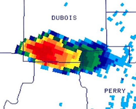
At the start of the event, a severe storm was shown in base reflectivity data (lowest radar elevation) across southern Dubois County in south-central Indiana (northwest of Louisville). The storm was moving east-northeast producing strong winds and hail. The heaviest rain and hail were located in the western quadrant of the storm (red colors) with lighter rain to the east in the storm's downstream anvil. |
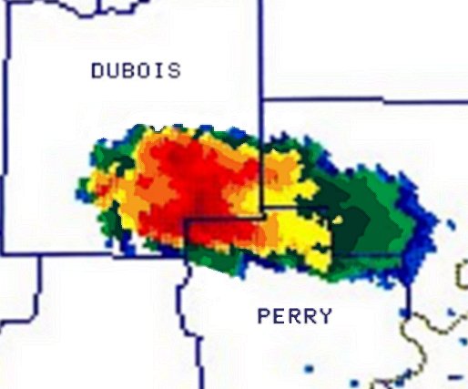 |
A short time later, the storm began to "split" into two cells over southeastern Dubois County as the storm continued to track east-northeast. The image shows two distinct areas of red colors in reflectivity data, suggesting development of two distinct updrafts within the overall storm complex. |
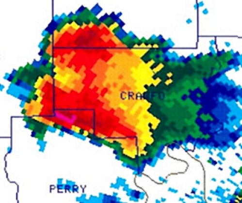 |
The storm complex continued to undergo the splitting process as it moved into neighboring western Crawford County, Indiana. Two distinct cells were now apparent. Note that the tightest reflectivity gradient was on the south side of the southern storm and the north side of the northern storm. This is typical in "mirror-image" splitting storms and represents the most likely location within these type of storms for severe weather phenomena. |
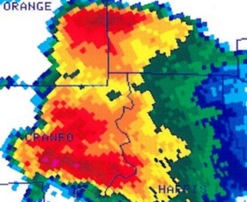 |
About 10 minutes later, the splitting process was nearly complete. Note that the red colored areas were now completely separate with lighter reflectivity returns between the two storms. The area of lower returns was likely a downdraft area that was promoting the split. The main updraft was located on the northern side of the northern storm, and southern side of the southern storm. The southern storm started to take on some curvature on its southern flank indicating an increase in severe weather activity. |
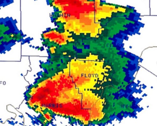 |
A short time later, the storm had completely split with two storms. The "left mover" (northern storm) moved northeast and produced strong winds and hail, then weakened after this time. The southern storm became a "right-mover" and turned east-southeast. It evolved into a classic supercell with a hook echo on its southwest flank, and a "V notch" downwind (note the red colors) indicating a powerful storm producing a blocking flow pattern aloft. The first tornado (F2) touched down around this time in a wooded area of central/southern Harrison County, Indiana. The tornado was coincident with the small area of red color on the southeast edge of the hook. |
.jpg) |
The intense supercell continued to move east- southeast into northeast Bullitt, southeast Jefferson, and Spencer counties in north-central KY. While the first tornado dissipated in Harrison County, golfball size hail fell in southern Jefferson County (near Louisville). Identified is the hook echo over Bullitt County indicative of a strong, cyclonically-rotating updraft (mesocyclone) wrapping precipitation around the circulation. A second strong tornado (maximum strength F3-F4) developed and was on the ground at the edge of the hook. Just north of the tornado, large hail and very heavy rain were occurring (dark red/pink colors). Downwind, a definitive "V notch" was evident. |
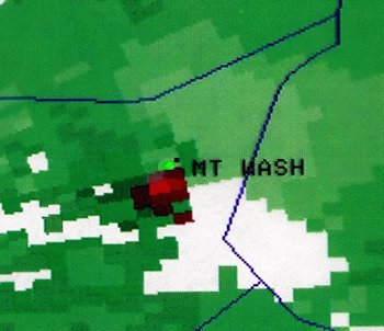 |
This is a low-level storm-relative velocity (SRM) image at the same time as in reflectivity above. Green colors are storm-relative radial winds directed toward the radar (located at Ft. Knox west of the image); red is flow away from the radar. A tight tornado vortex signature (TVS) is evident near the town of Mt. Washington in northeast Bullitt county (20-25 miles east of the radar), which was coincident with the hook echo in the corresponding reflectivity image above. The TVS was associated with a strong tornado on the ground. Just northeast of the TVS, light green colors denoted strong storm-relative flow into the parent mesocyclone of the supercell |
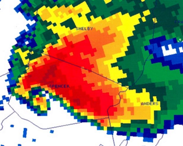 |
The storm continued east into Spencer county, KY where a mature hook echo still was evident on the supercell's southwest quadrant. The tornado was still on the ground at this time at the location of the small area of red color in the southeast quadrant of the hook. The tornado produced significant structural damage to homes and uprooted and debarked numerous trees. Heavy rain and hail continued just north and east of the hook, while the "V notch" was still evident. |
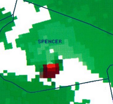 |
Corresponding storm-relative velocity data for the reflectivity image shown above. The radar is located west (left) of the image. A tight circulation again was evident over south-central Spencer County, coincident with the hook in the reflectivity image above. The associated tornado eventually weakened and lifted over eastern Spencer county, although 2 additional, but weaker (F0-F2) tornadoes occurred along the storm's path over east-central KY. The storm then gradually weakened and was overtaken by an approaching squall line (not shown). |
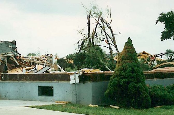 |
Storm damage from the tornado which struck northeastern Bullitt County on May 28, 1996. Note that nothing was left of this house except for its foundation. The house was swept off its foundation by the force of the wind. |


 Weather Story
 Weather Map
 Local Radar