Louisville, KY
Weather Forecast Office
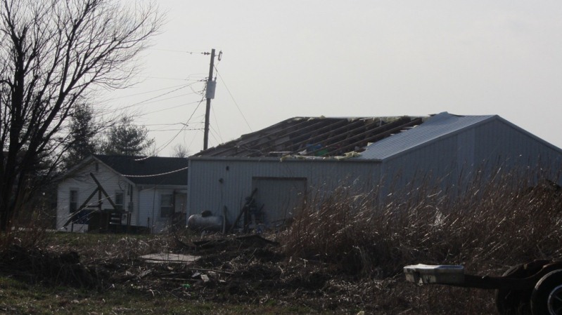
Strength: EF-2
Wind Speed: 120 MPH
Path Length: 0.9 mile
Path Width: 100 yards
Estimated touchdown/ending time: 11:12 AM EST - 11:15 AM EST
A National Weather Service Survey Team in conjunction with LaRue County EMA determined a tornado touched down just south of Miami Court and moved east through a wooded area. Several witnesses saw two different tornadoes near the Miami Court and Wobegona Way area. The second funnel cloud/tornado, described here, was near tree top level. It was only 50 yards wide twisting many trees and was rated EF0. As it crossed Highway 210 the twister increased to 100 yards wide and became stronger. It damaged a large working garage and damaged two homes off of Highway 916 including a new well and almost finished newly constructed home which experienced significant exterior wall damage. Workers working on the home heard a loud roar while seeking shelter and observed the twister striking and uprooting some trees. A dumpster full of old building material was thrown 75 yards and snapped a telephone pole. The twister lifted in a field a couple of hundred yards downwind. The twister was rated EF2 at this location.
Damage in LaRue County from the official NWS storm survey team:
Current Hazards
Hazardous Weather Outlook
Storm Prediction Center
Submit a Storm Report
Advisory/Warning Criteria
Radar
Fort Knox
Evansville
Fort Campbell
Nashville
Jackson
Wilmington
Latest Forecasts
El Nino and La Nina
Climate Prediction
Central U.S. Weather Stories
1-Stop Winter Forecast
Aviation
Spot Request
Air Quality
Fire Weather
Recreation Forecasts
1-Stop Drought
Event Ready
1-Stop Severe Forecast
Past Weather
Climate Graphs
1-Stop Climate
CoCoRaHS
Local Climate Pages
Tornado History
Past Derby/Oaks/Thunder Weather
Football Weather
Local Information
About the NWS
Forecast Discussion
Items of Interest
Spotter Training
Regional Weather Map
Decision Support Page
Text Products
Science and Technology
Outreach
LMK Warning Area
About Our Office
Station History
Hazardous Weather Outlook
Local Climate Page
Tornado Machine Plans
Weather Enterprise Resources
US Dept of Commerce
National Oceanic and Atmospheric Administration
National Weather Service
Louisville, KY
6201 Theiler Lane
Louisville, KY 40229-1476
502-969-8842
Comments? Questions? Please Contact Us.


 Weather Story
 Weather Map
 Local Radar