|
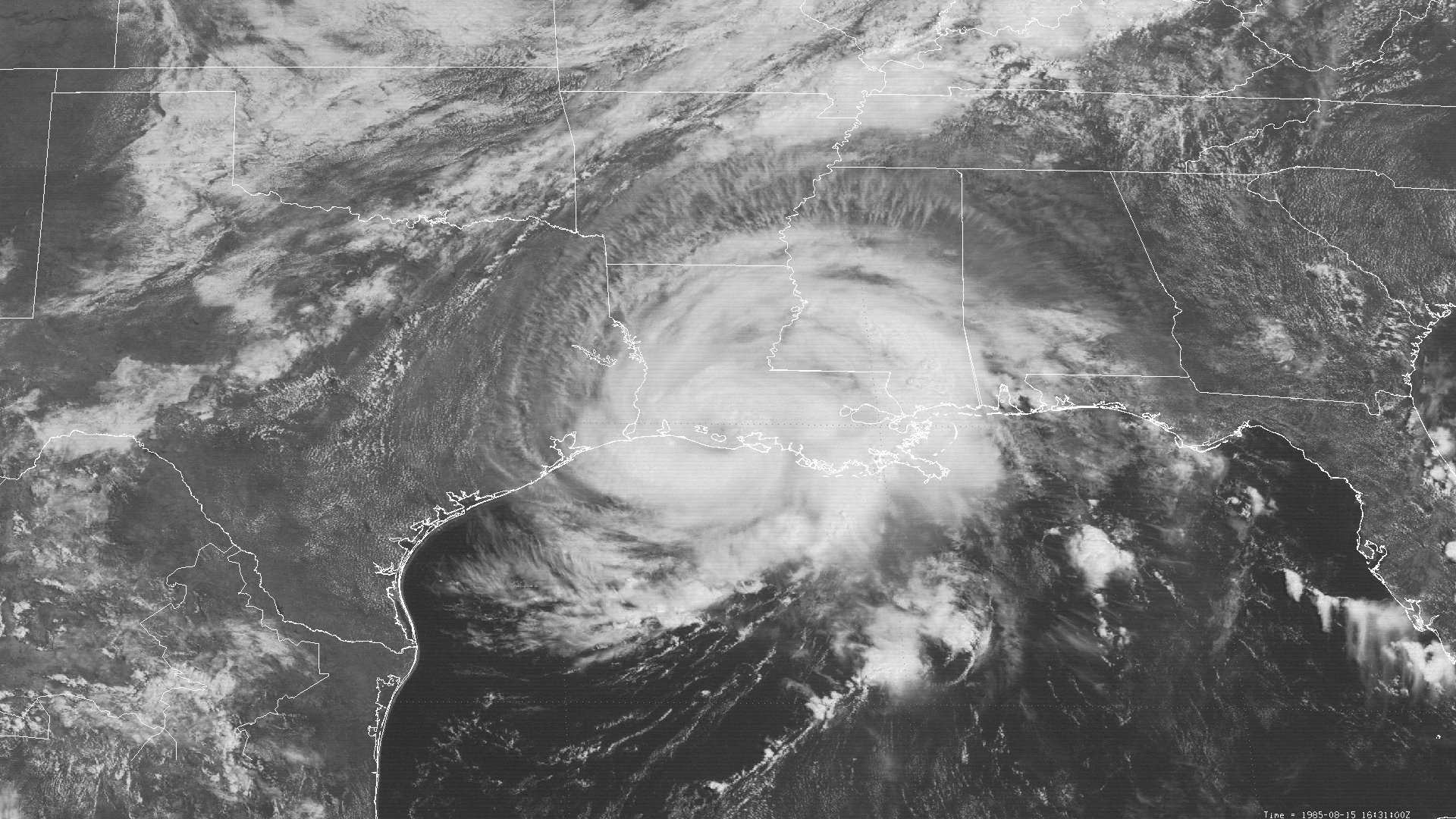
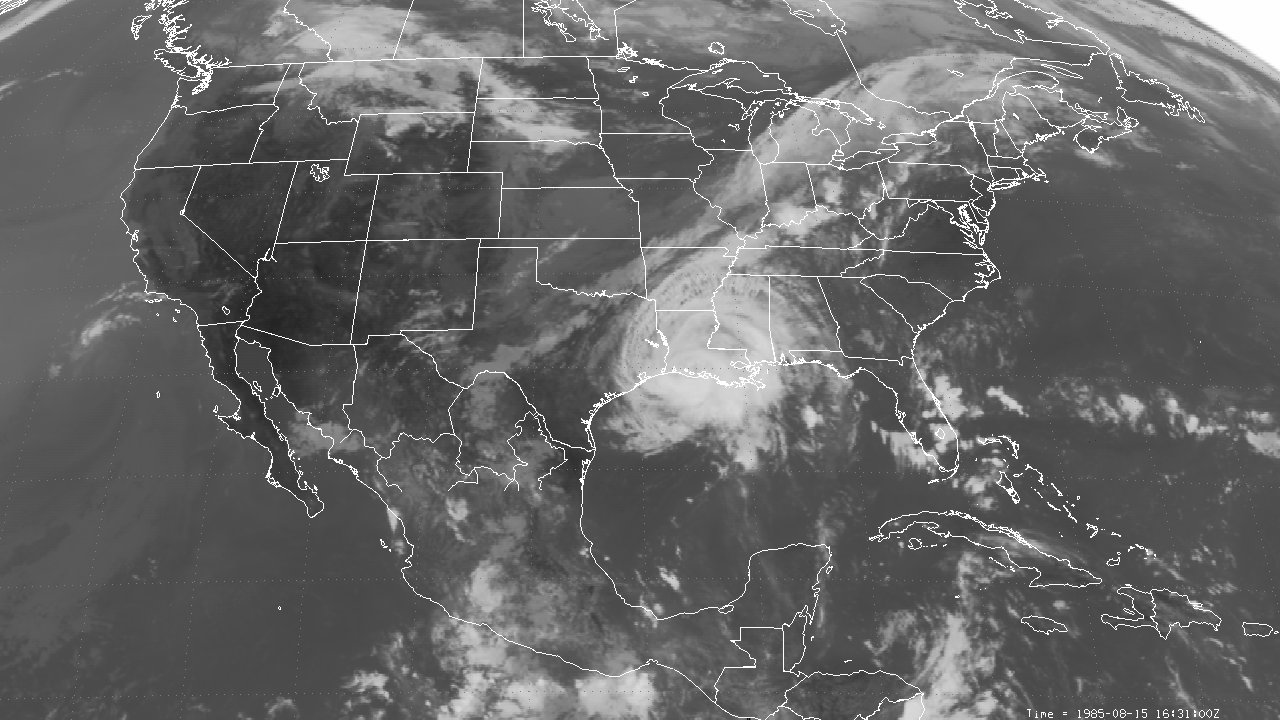
Above: GOES-6 visible satellite image of Hurricane Danny at landfall across South Central Louisiana at 11:31 AM CDT August 15, 1985.
Hurricane Danny originated from a tropical wave that moved off the west coast of Africa on July 30th. The wave tracked westward within the easterly trade winds with little organization, entering the Eastern Caribbean on August 8th. Showers and thunderstorms associated with the tropical wave gradually increased as the wave tracked westward across the Eastern and Central Caribbean. By August 10th, a broad surface low pressure was analyzed across the Central Caribbean Sea south of Dominican Republic & Haiti. During the late evening hours of August 11th, Air Force reconnaissance aircraft found enough organization in the surface low pressure near the Cayman Islands, thus designated Tropical Depression #4.
High pressure at the surface and aloft over the Carolinas steered Tropical Depression #4 on a northwest track around 10 to 15 mph, reaching the western tip of Cuba and entered the Gulf early on August 13th. The depression gradually became better organized upon entering the Gulf, and was named Tropical Storm Danny by 5 PM CDT August 13th. Continuing on a northwest track at 10 to 15 mph, Danny began to intensify more rapidly across the Central and Northern Gulf with low wind shear and warmer sea surface temperatures in the low to mid 80s. Danny was upgraded to a minimum hurricane by 5 PM CDT August 14th located around 200 miles south of Morgan City, Louisiana.
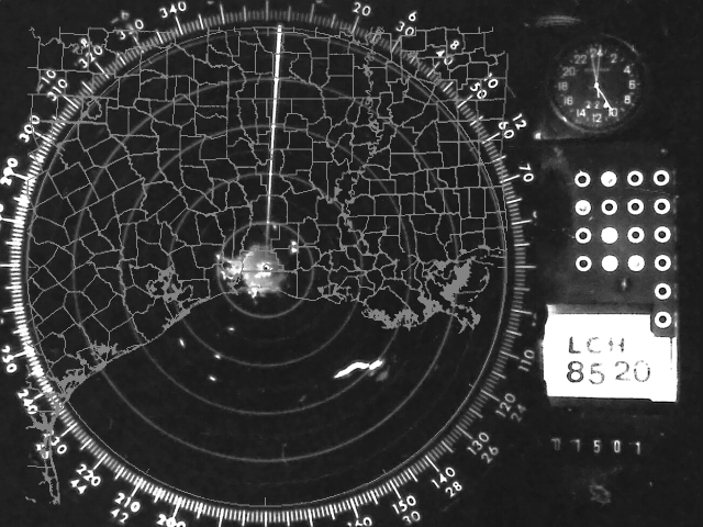
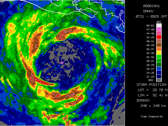
During the evening of August 14th through August 15th, the mid to upper level ridge centered over the Carolinas shifted a little to the east while a mid to upper level trough just east of the Rocky Mountains dug further south across New Mexico and the Texas & Oklahoma Panhandles. This provided a continued favorable mid to upper level environment with low wind shear over the Northern Gulf. This allowed Hurricane Danny to intensify further and move toward the north northwest at 10 to 15 mph towards the Louisiana coast. By the early morning hours of August 15th, NOAA reconnaissance aircraft indicated that Danny continued to strengthen with maximum sustained winds of 70 knots (80 mph) and the development of an eye around 55 miles wide. Pictured here is a NOAA aircraft composite radar between 2:31-4:25 AM CDT (0731Z-0925Z) August 15th when the eye of Danny was centered about 60 miles south of Pecan Island, Louisiana.
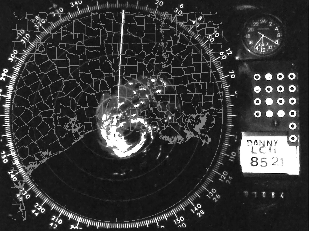
Hurricane Danny strengthened further during the final hours before landfall, with the eye contracting a bit, still remaining fairly large with a diameter of 40 to 45 miles wide, as shown by a WSR-57 radar imagery from the National Weather Service Lake Charles, LA at 9:30 AM CDT August 15th. Danny reached its maximum intensity as it made landfall near the Cameron & Vermilion Parish Line at Rockefeller Wildlife Refuge, Louisiana around 11:30 AM CDT August 15th with maximum sustained winds of 90 mph (80 knots) and a minimum sea level pressure of 987 millibars (29.15 inches). GOES-6 visible & infrared satellite imagery shows Hurricane Danny at landfall.
Now heading north at 10 to 15 mph, Hurricane Danny maintained organization for the next couple of hours while traversing the marshes of Cameron & Vermilion Parishes. Danny weakened further to a tropical storm by 7 PM CDT south of Alexandria, Louisiana and moved northeast over Northeast Louisiana for the remainder of the evening into the early morning hours of August 16th. Danny weakened to a tropical depression by 7 AM CDT near the Louisiana, Arkansas, & Mississippi border. Danny moved east northeast across northern Mississippi & Alabama, Tennessee, and North Carolina the next three days, becoming extratropical as it exited into the Atlantic late on August 19th. Click here for an interactive track of Hurricane Danny.
Hurricane Danny caused moderate wind damage across Southwest, Central and South-Central Louisiana. Numerous trees were uprooted, powerlines and poles were broken or downed with extended power outages, and extensive tree limb breakage. Signs and billboards were toppled, along with damage to roofs, plate glass, mobile homes, barns and lighter structures.
Where the eye of Danny made landfall and points eastward across Eastern Cameron, Vermilion, Iberia, and St. Mary parishes, tides of 5 to 8 feet inundated the immediate coastline, marshes, and low-lying coastal communities of Pecan Island, Intracoastal City, Delcambre, and Cypremort Point, Louisiana. The storm surge and wave action caused some coastal erosion, especially to the barrier islands off of South Central and Southeast Louisiana.
WIND & PRESSURE:
Tropical storm force winds occurred across most of Southwest, Central and South-Central Louisiana. Sustained hurricane force winds were mainly confined to the eyewall across Eastern Cameron and Vermilion Parishes where Danny made landfall as measured from reconnaissance aircraft. Official surface observations were not available across most locations within the eye or eyewall passage. The highest un-official measured gust on land of 75 mph (65 knots) was measured by Terry Nixon, located along Highway 82 between Pecan Island and Rockefeller Wildlife Refuge, Louisiana, with an anemometer height noted at 10 feet. With most surface observing equipment having anemometer heights near 33 feet (10 meters), winds might have been slightly higher at that height. The Lafayette Regional Airport measured a 57 mph (50 knots) wind gust around 2:00 PM CDT August 15th, but observations were incomplete during the time of maximum winds, likely due to power outages. Across the coastal waters off the Louisiana Coast, much higher winds were reported from the oil and gas production platforms, especially within the eyewall. The highest report received across the coastal waters was measured at the oil production platform EC42B with maximum sustained winds of 92 mph (80 knots) and a peak gust of 116 mph (101 knots) at 8:15 AM CDT August 15th. The anemometer height above water at this site was 70 feet with good exposure noted. Most of these platforms have anemometer heights much higher than land-based stations, and vary from site to site. For complete meteorological statistics, see the Wind and Pressure section.
STORM SURGE:
Across Eastern Cameron, Vermilion, Iberia, and St. Mary parishes in Louisiana, tides of 5 to 8 feet NGVD inundated the immediate coastline, marshes, and low-lying coastal communities. The highest water level found was 7.9 feet MSL at Old Vermilion Locks, Louisiana. Other high-water levels include: Lukes Landing just north of Point Chevreuil with 7.7 feet NGVD, Vermilion Lock, East with 7.1 feet NGVD, Freshwater Bayou Lock at 6.7 feet NGVD, and across the Atchafalaya Bay at Eugene Island with 6.7 feet NGVD. Further west from Cameron, Louisiana to Sabine Pass, Texas, tides of 3 to 4 feet NGVD inundated the immediate coastline. For other storm surge and high-water marks, see the Storm Surge section.
RAINFALL:
Rainfall of 3 to 6 inches was recorded across Central and Southern Louisiana with the greatest total of 6.16 inches at Rockefeller Wildlife Refuge, Louisiana. Across Western Louisiana and Southeast Texas, lower rainfall totals of ½ to 2 inches were recorded. For complete rainfall totals reported across our region, see the Rainfall section.
TORNADOES:
An F1 tornado was recorded at Hackberry, Louisiana around 12:45 PM CDT August 15th, damaging a couple of trailers. Two other tornadoes were reported across Southeast Louisiana in Jefferson and St. Bernard Parishes. No injuries or fatalities were reported from these tornadoes. For complete details on all the tornadoes reported across our region, see the Tornadoes section.
Above: NWS Lake Charles, LA WSR-57 radar animation of Hurricane Danny from 5:00 AM CDT August 14, 1985 through 9:30 AM CDT August 16, 1985.
|

