|
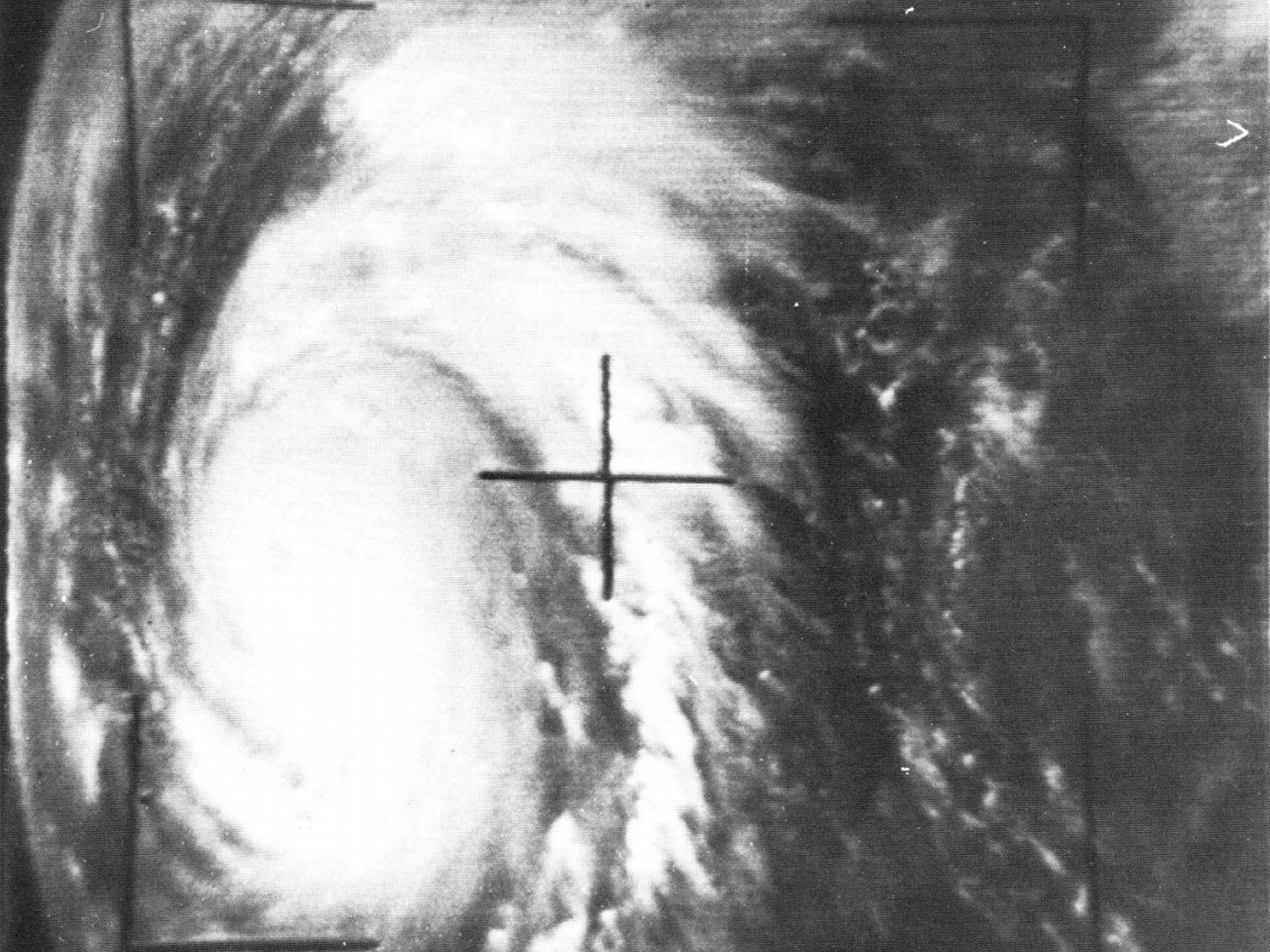
Above: TIROS-8 visible satellite photo of Hurricane Hilda near peak intensity midday on October 1, 1964.
On September 28th, a tropical depression developed south of Trinidad, Cuba. The depression tracked west-northwestward and strengthened into Tropical Storm Hilda while making landfall near Sandino, Cuba just before daybreak on September 29th. Hilda emerged into the southeastern Gulf of America later that morning.
Strong high pressure ridging aloft off the Southeastern United States to the Gulf of America allowed Tropical Storm Hilda to continue west northwest across the Central Gulf and strengthen into a minimal hurricane around daybreak September 30th. For the next 30 hours, Hilda underwent rapid intensification, reaching a peak intensity of 140 mph (120 knots) and a minimal central pressure of 941 millibars (27.79 inches) around Noon CST on October 1st, as pictured in this TIROS-8 visible satellite photo. As high pressure aloft weakened with a digging longwave trough over the Central United States, Hilda began to re-curve northward and gradually weaken October 2nd and 3rd as it headed for the South-Central Louisiana coast.
Hurricane Hilda made landfall just southeast of Burns Point, Louisiana around 5 PM CST on October 3rd as a Category 2 hurricane with winds of 105 mph (90 knots) and a minimal central pressure of 959 millibars (28.32 inches). Hilda steadily weakened after landfall and began to turn northeast, falling just below hurricane strength by daybreak on October 4th. A strong cold front and upper level trough approaching from the northwest steered Hilda eastward across the remainder of Southeast Louisiana and Southern Mississippi, remaining a strong tropical storm. With cooler and drier air entrainment into the system, Hilda became extra-tropical by sunset on October 4th as it merged with the cold front across the Florida Panhandle. Click here for an interactive track of Hurricane Hilda.
Hurricane force winds from October 1st to the time of landfall on the 3rd destroyed or damaged many offshore drilling platforms, which resulted in the costliest hurricane to the Louisiana oil industry at the time.
Damage to homes and businesses across South Central Louisiana, especially in the areas of hurricane force winds, occurred. Damage to agricultural was extensive, particularly to the sugarcane and cotton industry.
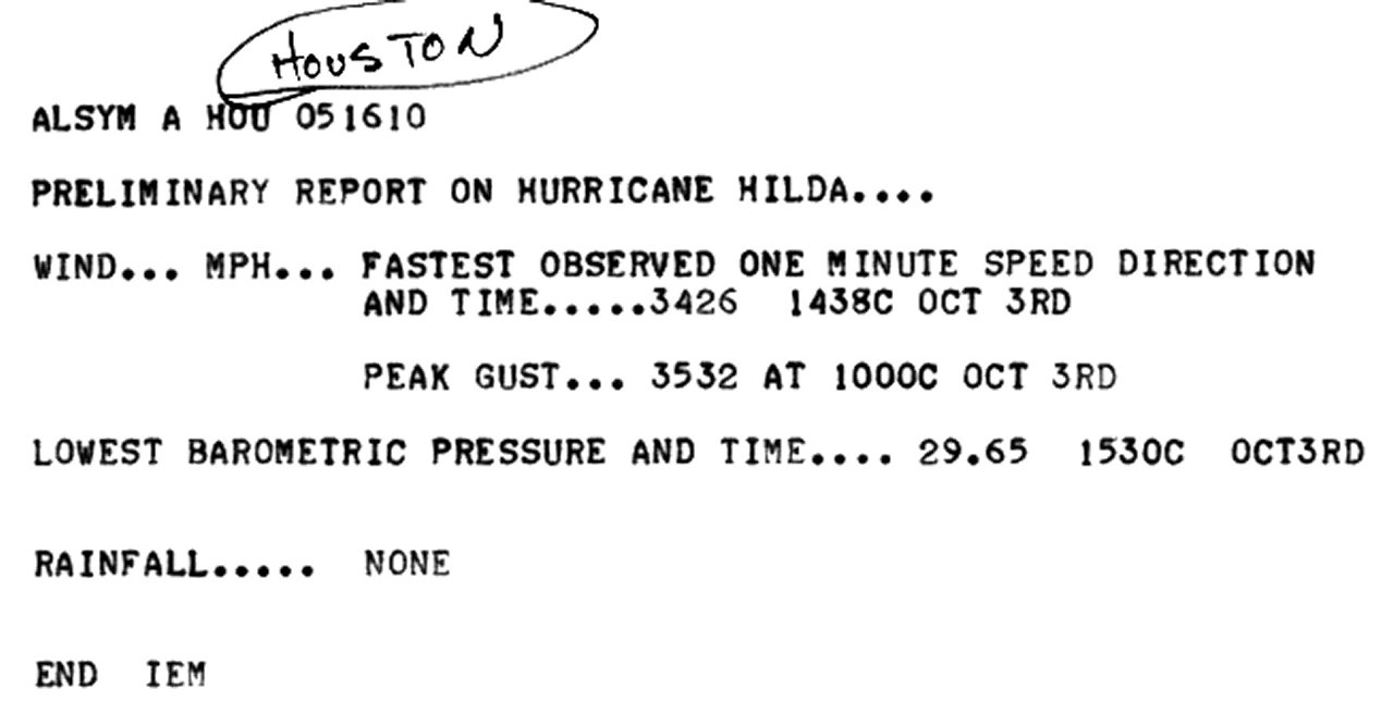
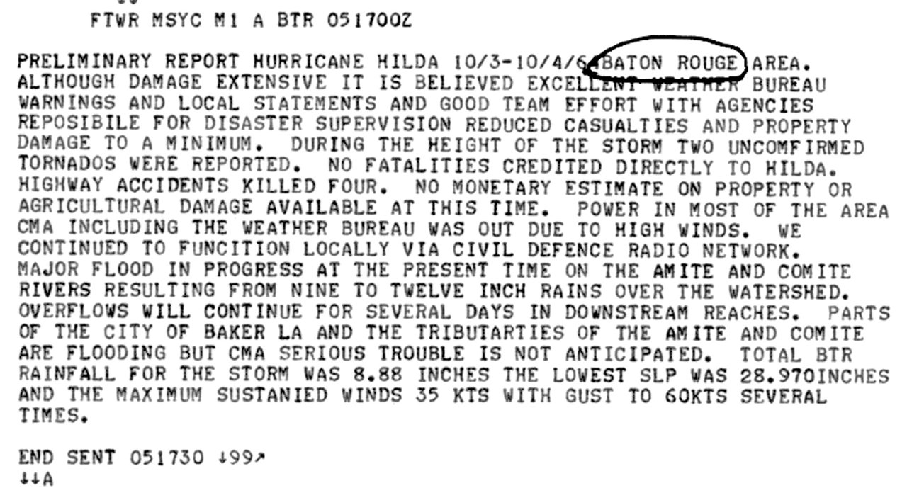
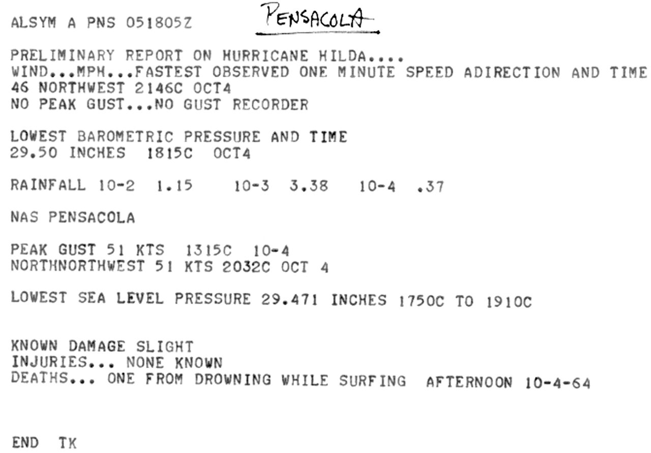
WIND & PRESSURE:
Vermilion, Iberia, St. Mary, and lower St. Martin parishes took the brunt of Hurricane Hilda’s hurricane force winds. The eye of Hilda passed over Franklin, Louisiana around 6:10 PM CST where a central pressure of 961.7 millibars (28.40 inches) was measured and an un-official wind gust of 120 mph. Across Vermilion parish, Abbeville reported an un-official wind gust of 110 mph. In Erath, a 125-foot-tall water tower collapsed onto the Erath City Hall, being used by Civil Defense personnel, killing eight people inside the collapsed building. Hurricane force wind gusts were also felt further north across Lafayette and northern St. Martin parishes. The Lafayette airport reported a peak sustained wind of 69 mph (60 knots) and a peak gust of 92 mph (80 knots) between 6:30-7:00 PM CST on October 3rd, along with a minimal sea level pressure of 985.4 millibars (29.10 inches). For complete meteorological statistics, see the Wind and Pressure section.
STORM SURGE:
Storm surge high water marks across Iberia and St. Mary parishes ranged from 3-6 feet MSL, with higher readings up to 10 feet MSL measured across Terrebonne parish. An un-official report of 10 feet was at Point au Fer Reef Lighthouse near Eugene Island just off the mouth of the Atchafalaya River. For other storm surge and high-water marks across our region, see the Storm Surge section.
RAINFALL:
The heaviest rainfall of 10 to 17 inches occurred across South Central and Southeast Louisiana, with the highest rainfall total of 17.71 inches northwest of Jeanerette. Considerable flooding occurred across South Central and Southeast Louisiana, which also damaged homes and businesses. For complete rainfall totals reported across our region, see the Rainfall section.
TORNADOES:
Early on October 3rd through early on October 4th, several tornadoes occurred across Southeast Louisiana. On October 3rd around 6:00 AM CST, an F1 tornado affected Golden Meadow in Lafourche parish. At 6:30 AM CST, one of the strongest and deadliest tropical cyclone tornadoes ever recorded in the state of Louisiana occurred at Larose in Lafourche parish. This tornado was rated an F4, killed 22 people and injured 165 others. At 9:00 AM CST, an F2 tornado tracked across Orleans and Jefferson parishes affecting areas from Kenner to New Orleans, causing 5 injuries and 2.5 million in damages. An F2 tornado occurred at 11:10 CST in Napoleonville in Assumption parish. On October 4th around 3:25 AM CST, an F2 tornado occurred in Madisonville in St. Tammany parish. For complete details on all the tornadoes reported, see the Tornadoes section.
|

