|
|
2007:
WEATHER OF THE
SOUTH PLAINS
|
|
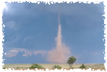
| A landspout tornado in Hale County - 27 September |
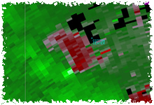
Radar velocity image of a tornadic mesocyclone to the southwest of Cotton center - 17 April |
|
The year of 2007 brought a wide variety of weather to West Texas. Severe weather season kicked-off early in March. April brought a late freeze, affecting some agriculture. April also saw more tornadoes, including the one that hit Tulia. Severe weather quieted down by May, although some heavy rain fell. The spring and summer seasons were also significantly cooler than normal. In mid-August, tropical storm Erin tracked across the Rolling Plains. Fall generally brought drier and mild weather. The year ended on a interesting note, when a storm system brought a few weak tornadoes to the South Plains on December 27th.
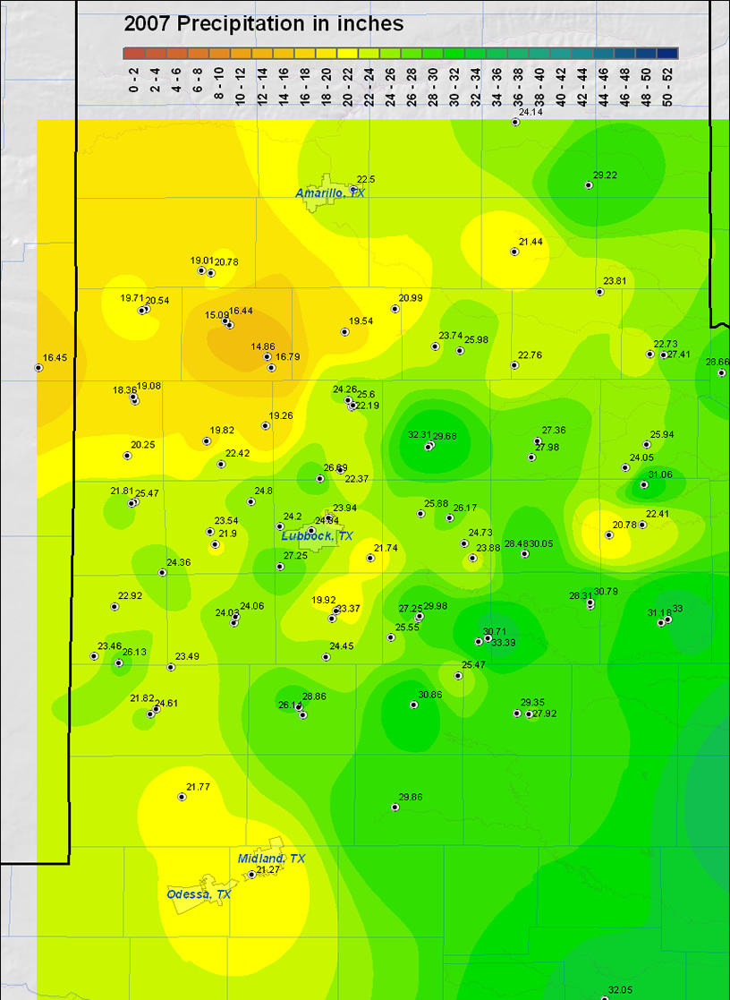
For the year, above average rainfall fell across much of the South Plains and southern and western Rolling Plains. This was aided by a record monthly rainfall of 5.94 inches at the Lubbock International Airport in March. However, there also was a month-long dry spell for much of the area from mid-October to mid-November, and some locations across the southern Texas Panhandle and portions of the central and northern Rolling Plains recorded yearly rainfall totals at or somewhat below normal. The following two maps display the precipitation recorded across the area for the year of 2007 and the departure from normal, respectively.
|
|
|
|
The map above was created from yearly precipitation totals gathered from West Texas Mesonet Stations and NWS Cooperative observation stations. Please click on the map to view a full-sized version.
|
|
|
| This map shows the rainfall departures from the 30 year normals (1971-2000). Please click on the map to view a full-sized version. |
Below are some of the statistics from 2007 for Lubbock and around the region:
The first half of the year showed great variability in the high temperatures, thanks mostly in part to numerous weather systems moving through with above average periods of precipitation and cloud cover. The second half of the year saw high temperatures more near average, with a slight warm bias, as precipitation became less frequent. This cool/wet to dry/mild transition proved to be conducive for an excellent cotton harvest across the region in 2007. Only two temperature records were broken at Lubbock, both high temperatures: 92 degrees on October 20th, and 79 degrees on December 7th. In fact, no 100 degree days were recorded at Lubbock during 2007, only the 5th time since records have been kept that this has occurred. The following chart shows the monthly summary of temperature and precipitation at the Lubbock Airport.
|
LUBBOCK
|
Average High
|
Average Low
|
Precip (inches)
|
|
January
|
46.1
|
26.7
|
1.12
|
|
February
|
58.8
|
28.4
|
0.36
|
|
March
|
68.4
|
42.9
|
5.94 (Record)
|
|
April
|
68.4
|
43.2
|
1.23
|
|
May
|
77.4
|
56.1
|
5.35
|
|
June
|
86.7
|
62.4
|
3.39
|
|
July
|
89.3
|
65.6
|
0.94
|
|
August
|
91.1
|
68.2
|
1.99
|
|
September
|
86.6
|
61.8
|
2.20
|
|
October
|
80.7
|
49.5
|
0.28
|
|
November
|
65.3
|
36.0
|
0.20
|
|
December
|
55.4
|
28.3
|
0.94
|
|
Annual
|
72.8
|
47.4
|
23.94
|
|
Normal
|
73.2
|
46.2
|
18.69
|
|
Departure
|
-0.4
|
+1.2
|
+5.25
|
The two graphs below show the daily temperature distribution throughout the year at the Lubbock Airport. It can be seen on the first graph how the high temperatures were generally variable through Spring, then mainly below the normal curve (black line) from May through July, then climbing above the normal curve through November, and then finally became highly variable again in December. Low temperatures generally followed the same pattern, though with less variability overall.
|
|
| Plot of the maximum (top) and minimum temperatures (bottom) observed at the Lubbock airport in 2007. Click on the images for a larger view. |
|
|
The graph below shows the yearly distribution of precipitation. The wettest period occurred from around mid-March to early June. Also note the dry period beginning in October.
|
|
| Plot of the cumulative and daily precipitation in inches recorded at the Lubbock airport in 2006. Click on the image for a larger view. |
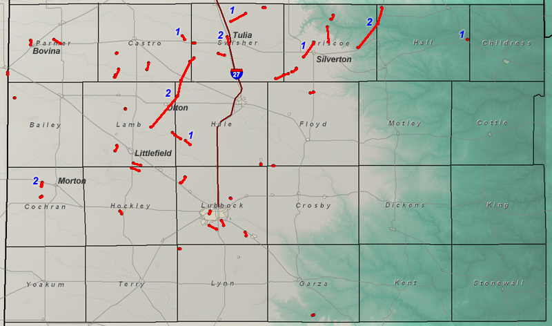
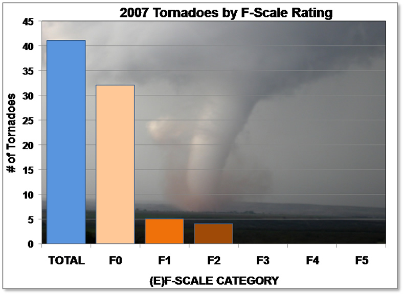
2007 saw a very active year in terms of the number of tornadoes reported. 41 tornadoes were observed through the 26th of December. Reports of several more tornadoes were received on December 27th and thus the final count for 2007 may be slightly higher once these are confirmed. This is a yearly record for the Lubbock forecast area. 2007 was also the year when the National Weather Service implemented a new enhanced Fujita Scale or "EF-Scale" which slightly modifies the wind speed criteria for each category. For more information on this change please visit this webpage from the Storm Prediction Center.
|
|
| Map showing the tornado paths across the Lubbock county warning area in 2007. The EF-scale rating of tornadoes greater than EF-0 is shown on the map. Please click on the map to view a larger version. Note, possible EF-0 tornadoes on December 27th are not shown. |
|
|
|
The distribution of area tornadoes in 2007 by (E)F-scale rating.
(Click on image to view larger version)
|
|
|
|
The distribution of area tornadoes in 2007 by time of year
(Click on image to view larger version)
|
|
|
|
The distribution of area tornadoes in 2007 by time of day
(Click on image to view larger version)
|
| |
| |
12-14th: A cold but shallow arctic air mass combined with an upper level storm system to bring periods of freezing rain and freezing drizzle. Over the entire event several locations across the South Plains received between one half and one inch of ice accumulation, with many other seeing lighter amounts. The ice buildups caused approximately 245 auto-accidents, including two fatalities and nine other serious injuries.
19-20th: For the second weekend in row, another major winter storm impacted the South Plains. This storm produced up to a foot of snow across portions of the southwest Texas Panhandle, with lighter snow amounts combined with a coating of ice farther southeast. For more CLICK HERE.
Mid Jan: Comet McNaught, discovered in August of 2006, became a spectacular view by the middle of January of 2007. In particular, the comet’s tail grew so enormous that it remained visible in the northern hemisphere well after the comet passed out of view. For more information on Comet McNaught CLICK HERE.
23rd: An upper level storm system that stalled over northern Mexico and the Big Bend brought a broad area of wintry precipitation to the Trans Pecos region and the plains of southeast New Mexico late on the 22nd and early on the 23rd. Some of this activity spread northeastward, bringing several hours of light snow across the southwest South Plains. Wellman reported 3 inches of snow, Denver City 2 inches, with Brownfield, O’Donnell, and Wells each receiving an inch.
1-2nd: A nearly stationary cold front was the focus for several narrow by heavy bands of snow that formed over portions of the southern South Plains and Rolling Plains. Aspermont was the big winner, picking up a quick 7 inches, while Lake Alan Henry came in second with 4 inches. Other locations, from Jayton to O’Donnell to Littlefield to Lubbock to Plainview all had 2-3 inches, with lighter amounts over the remainder of the area.
14th: Valentine’s Day brought intermittent light to moderate snow to much of the region, with 1-2 inches of total accumulation at most locations. However, one more persistent area of moderate snow resulted in 4 inches at Farwell, and 3 inches at Dimmitt. The winter weather did cause at least 125 vehicle accidents, with a majority of them in Lubbock.
24th: A powerful storm system brought high winds, dust, and even snow to the region. The strongest winds recorded peaked at 70 mph at the West Texas Mesonet Station at Reese Center. The strong winds damaged many roofs and light weight metal structures, broke windows, and downed utility poles/lines. Also, the strong winds lifted loose top-soil to produce an intense dust storm and cause multiple vehicle pile-ups and one injury. For more on the event CLICK HERE.
28th: A strong storm system brought windy conditions to the South Plains, with wind gusts between 45 and 55 mph common. The West Texas Mesonet near Plains recorded the strongest gust at 58 mph.
10th: An intense thunderstorm produced strong winds and a brief tornado to the Estelline area. The strong winds rolled and destroyed a mobile home, but thankfully the family of four inside escaped with only minor injuries. For more information CLICK HERE.
10-12th: A nearly stationary storm system brought a number of rounds of rain to the region, with many locations see between 2 and 5 inches. Particularly heavy on the 12th did result in some flooding over portions of northwest Lubbock, as well as near Levelland. Read more HERE.
21st: A severe thunderstorm tracked from north of Brownfield to near Meadow, producing up to half dollar size hail.
23th: Scattered severe thunderstorms moved across the northwest South Plains and southwest Texas Panhandle out of eastern New Mexico late in the day. The storms produced widespread wind damage and at least 5 tornadoes. To learn more CLICK HERE.
25th: A weak front, moist atmosphere and moderate instability combined to bring two rounds of landspout tornadoes. The first series of at least 4 tornadoes occurred during the Sunday lunch hour just southeast of Lubbock. Later in the afternoon the boundary moved northwest and help produce at least two more tornadoes, one west of Tulia and another west of Hart. Additionally, the thunderstorms produced flash flooding at various places across the South Plains. For more information on this event CLICK HERE.
28th: A pair of tornadic supercells tracked northeastward across the extreme southeastern Panhandle through the early evening. These two storms produced a total of seven tornadoes in the South Plains region, hitting areas near Silverton and Antelope Flat the hardest. Later that evening, a line of severe storms brought widespread large hail and damaging winds to many locations across the South Plains. To learn more CLICK HERE.
7th: Easter weekend brought cold weather and a late season snowstorm that produced a trace to 4 inches of snow across the region. Aspermont led the way, tallying 4 inches, with a swatch of 2-3 inches from Littlefield and Levelland east through Lubbock and Paducah. For more detailed information CLICK HERE.
10th: An intensifying storm system brought severe wind gusts and blowing dust to portions of the southwest Panhandle. The West Texas Mesonet near Friona recorded a top gust of 63 mph, with Hart, Olton and Dimmitt gusting to 58-60 mph.
12th: Scattered strong to severe thunderstorms brought high winds and large hail to portions of the northern South Plains and southeast Panhandle. The strong winds did down large tree limbs just east of Quitaque and produce quarter size hail near Vigo Park.
13th: A line of thunderstorms brought gusty winds and marginal severe hail to parts of Lubbock, as well to Old Glory early in the day. Later, a strengthen storm system brought severe wind gusts to the south central and southwest South Plains. Denver city recorded a maximum wind gust of 61 mph.
17th: Very cold mid-level temperatures combined with strong heating to produce numerous thunderstorms across the region. Additionally, some of thunderstorm developed over a stalled frontal boundary, and when coupled, the updrafts where able to stretch the low-level circulations upward resulting in landspout tornadoes. All told, 6 weak tornadoes were documented in and Lubbock Counties. Also, the storms were efficient hail producers. To learn more CLICK HERE.
20th: An isolated low precipitation supercell produced between quarter and ping pong ball size hail from southwestern Swisher County to north of Tulia.
21st: An outbreak of severe weather impacted much of the central U.S. from Minnesota to Texas, including a series of significant tornadoes from parts of the South Plains into the Panhandle. Both Olton and Tulia were struck by EF-2 tornadoes, causing 4 injuries and over 3 million dollars in damage. To learn much more, CLICK HERE.
23rd: A cluster of severe storms brought large hail to portions of Garza, Kent and Crosby Counties. Although most of the hail ranged in size from nickel to golf ball, one report of tennis ball size hail was received about 10 miles northeast of Post.
30th: An isolated thunderstorm produced a brief, weak landspout tornado south of Dimmitt.
5th: Scattered thunderstorms produce a couple of isolated severe hail reports, including nickel size hail in Memphis and quarter to golf ball size hail 3 miles north of Tahoka.
8-10th: A persistent upper-level storm system brought a couple of rounds of moderate to heavy rain across the South Plains region. Some of the heavier rain caused flooding, primarily in urban areas and construction zones on the 8th. Also, one storm brought nickel size hail to Childress. To learn more CLICK HERE.
20th: A line of thunderstorms brought damaging winds that destroyed an empty 500 gallon fuel tank, and a number of metal garages and storage units at an oil well west of Plains.
25th: During the early morning hours, an isolated strong thunderstorm produced pea to ping pong ball size hail 10 miles west of Ropesville.
26th: A thunderstorm generated quarter size hail at Opdyke West, with other storms bringing heavy rain and flash flooding to portions of southern Bailey County, including in the community of Needmore and Enochs.
28th: Scattered thunderstorms produced large hail, damaging winds and very heavy rainfall, primarily over portions of the central and southern South Plains. Golf ball size hail was observed between Slide and Woodrow, with a 59 mph wind gust recorded near Post.
30th: A small area of high pressure in the wake of thunderstorm complex generated a wind gust to 60 mph near Silverton.
31st: A cluster of severe storms over southeastern Hale and western Floyd Counties produced very large hail (tennis ball size 13 miles southwest of Floydada, and baseball size 3 miles east of Cotton Center), at least two tornadoes and flash flooding. Both tornadoes, one about 2 mile south of Petersburg and the other around 15 miles southwest of Floydada, were short-lived.
1st: A round of severe thunderstorms brought winds measured up to 74 mph near Levelland and caused structural damage that left four families homeless. Also, wind-blown hail damaged thousands of acres of cotton over portions of Hockley and Terry Counties.
2nd: An active round of severe weather included scattered supercell storms that produced extremely large hail and at least 6 tornadoes (2 southwest of Dimmitt, 1 south-southeast of Earth, 1 west-southwest of Justiceburg, 1 south of Littlefield, and 1 north of Whitharral). However, damage this day was generally a result of large hail that broke windows and dented vehicles in Levelland and Meadow, where tennis ball and softball size hail fell, respectively.
3rd: A complex of strong to severe thunderstorms move eastward out of New Mexico into the western and central South Plains during the evening. One storm produced nickel size hail northeast of Plains, with heavy rains resulting in areas of flooding in northeast Terry County and over southern portions of the city of Lubbock.
6th: A stout storm system brought strong westerly winds and blowing dust to much of the region. The highest wind gust measured was 59 mph at the West Texas Mesonet Site near Friona.
9th: Several clusters of severe storms produced gusty winds and up to penny size hail over portions of the southern and central South Plains. A wind gust to 67 mph was measured near Graham.
15th: One strong storm produced penny size hail 8 mile east of Post, while another brought 60 mph winds to the Jayton area.
19th: A long lived linear thunderstorm complex that produced extreme winds, known as a derecho, raked areas of the eastern Texas Panhandle through southwestern Oklahoma and western North Texas. An extreme wind gust of 89 mph was recorded near Memphis. Thankfully, structural damage was limited and no injuries were reported.
20th: An isolated storm produced penny size hail near Plains, resulting in minor crop damage.
22nd: A strong storm brought penny size hail near Friona, which severely damage cotton, wheat and alfalfa crops just east of town.
24th: A line of thunderstorm produced a measured gust to 58 mph near Floydada.
26th: Another derecho, this time over the western South Plains and Permian Basin, brought strong, especially to Yoakum, Terry and Lynn Counties. A measured gust to 81 mph was recorded near the TX/NM state line in western Yoakum County. The strong winds damaged many utility poles, lines, trees and cotton crops. Though no structural reports of damages were received, total electrical co-op and agricultural losses exceeded $1.5 million.
2nd: A short-lived storm produced nickel to quarter size hail in Brownfield.
9th: Scattered thunderstorms delivered large hail and severe winds to portions of the southern Texas Panhandle and northern South Plains. A wind gust to 64 was recorded near Abernathy, with quarter size hail observed near Happy.
10th: Isolated thunderstorm generated severe wind gusts over 60 mph near Ralls and Graham.
11th: Nickel size hail was observed in Plainview, Flomot, McAdoo and northeast of Floydada.
13th: Very heavy rainfall during the early morning hours produced flash flooding in many parts of Plainview.
2nd: A thunderstorm produced a brief but highly visible landspout tornado west-northwest of New Home during the early afternoon. No damage was reported.
7th: An isolated thunderstorm brought night to quarter size hail just south of Lubbock.
16-19th: Tropical Depression “Erin” dumped heavy amounts of rainfall across portions of West Texas, with the heavier amounts generally east of a Memphis to Lubbock to Tahoka line. The heaviest rains fell over the Southeast Panhandle and most of the Rolling Plains where 2 to 4 inches were common. The West Texas Mesonet near Aspermont recorded 6.10 inches. To read more about Erin CLICK HERE.
24th: A complex of severe storms developed over the southern Texas Panhandle and northwest South Plains. This complex evolved into a bow-shaped linear complex and produced widespread damaging wind, including a gust measured to 66 mph near Floydada. The high winds downed more than 50 utility poles in Hale County and resulted in minor structural damage caused by falling trees in Plainview.
28th: A full lunar eclipse was easily observable during the early morning hours. The eclipse brought one of the more memorable visual lunar eclipses with a very dark blood-red color. To see more about this event CLICK HERE.
SUMMER 2007: The region experienced a cooler than normal spring and summer during 2007. In fact, the temperature at the Lubbock International Airport failed to climb to 100 degrees for the first time since 1991. To read more about this CLICK HERE.
6th: An isolated thunderstorm produced a 60 mph gust at Slaton. Another more substantial complex of storms brought severe wind gusts and hail to 1 inch in diameter to parts of the southeast Texas Panhandle, northern Rolling Plains, and northeast South Plains. Childress recorded a wind gust to 64 mph.
7th: Scattered strong thunderstorms produced wind gusts estimated to 65 mph at Whitharral and 70 mph near Nazarath. The strong winds downed several power poles near Whitharral and destroyed two barns near Nazarath. Additionally, a tornado was observed southwest of Tulia.
25th: A cold front brought an impressive display of roll clouds to the South Plains during the early morning. Read more HERE.
26th: A small but stout thunderstorm complex moved across the central South Plains. The wind gusted to 63 mph at the Preston R. Smith Lubbock International Airport, with nickel size hail reported over portions of Lubbock.
27th: Strong thunderstorms brought large hail and high winds to a number of locations on and off the Caprock. One nearly stationary storm even produced a highly visible landspout tornado west of Cotton Center. Also, golf ball size hail was observed north of Paducah and near Kirkland. For a more extensive recap of the day CLICK HERE.
10th: A particularly intense thunderstorm moved south-southeast from southeast Castro County into eastern Lamb and western Hale Counties. A wind gust to 70 mph was measured by the West Texas Mesonet near Hart and baseball size hail near Halfway.
11th: Isolated severe thunderstorms brought quarter size hail near Tahoka and O’Donnell, with tennis ball sized hail at Maple.
16th: Hail to the size of golf balls was reported in the Happy vicinity.
Late Oct-early Nov: Comet Holmes is plainly visible to the naked eye after evolving from a tremendous explosion that took place on 23 October 2007. After the explosion, the comet increased in brightness a million-fold in less than 24 hours. To read more about this event CLICK HERE.
6th: The combination of high thin clouds and plentiful sunshine produced a rare solar halo to Lubbock. To see more CLICK HERE.
22-25th: Wintry Thanksgiving holiday weekend for the region as a large and potent winter storm brought three rounds of accumulating snowfall to portions of the South Plains. The first round on Thanksgiving brought generally 1-2 inches of the white stuff to the southern half of the South Plains, with 3-4 inches from Denver City to Brownfield to Tahoka. The second round fell from late on the 23rd to early on the 24th and brought a 0.5-2 inches to much of the area. The third and final round of the event primarily impacted the southern South Plains, with 3-4 inches reported from Plains to Tahoka, with very little much north and east of there.
9-11th: A strong storm system combined with shallow cold air and abundant moisture to bring a couple of rounds of cold rain and evening some stout thunderstorms. Although there was some minor ice accumulation over portions of the area, no significant travel problems materialized. To read more about this CLICK HERE.
14-15th: A quick hitting storm system brought accumulating snow to most of the southern Panhandle, northern South Plains and portions of the northern Rolling Plains. Locations in and around Olton led the way with around 6 inches. To read more about this CLICK HERE.
27th: A compact but potent storm system brought a variety of weather to West Texas, including snow, freezing fog, critical fire weather (windy and dry) and even weak tornadoes. To read more about this event CLICK HERE


