Lubbock, TX
Weather Forecast Office
 |
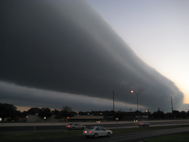
Early Tuesday morning, a cold front moved south out of the Panhandles and into the South Plains and Rolling Plains of West Texas. As the cold front passed by, there was a rather impressive display of roll clouds along the leading edge of the front. This type of horizontally oriented tube-shaped cloud is sometimes formed as warm air is lifted along the cold front. If the air being lifted is moist, as is rises it may condense into clouds. The laminar shape is caused by the stability of the air. That is, if there is a temperature inversion (temperature increases with height) above where the cloud layer is forming, the clouds may become "trapped" and form this particular shape. These can also occur in conjunction with thunderstorm outflows, and are commonly referred to as "shelf" clouds when they are attached to the thunderstorm base. Both roll and shelf clouds are forms of ARCUS clouds.
The following image shows a visible satellite image about the time the roll clouds were passing across the Lubbock area (about 6 to 8 am). You can see about four to five "bands" of roll clouds associated with the front.
 |
|
Satellite image at 6:55 am courtesy of the Texas Commission on Environmental Quality
|
The next image shows how the front looked via the National Weather Service Doppler Radar at Lubbock. Also in the image are surface observations from the West Texas Mesonet stations that indicate where the front was located (at the surface). The wave clouds slightly preceded the front at the surface.
 |
|
Map showing the reflectivity return from the Lubbock Radar along with surface observations and the approximate position of the cold front at 7 am. Click on the image for a larger version.
|
Below are some photographs of the roll clouds taken in Lubbock. The first five were taken from the National Weather Service Office at the Science Spectrum building on the south loop, and the final image was taken from a neighborhood in southwest Lubbock. Please click on each image to see a larger version.
 |
 |
 |
 |
 |
 |
US Dept of Commerce
National Oceanic and Atmospheric Administration
National Weather Service
Lubbock, TX
2579 S. Loop 289
Suite 100
Lubbock, TX 79423-1400
806-745-4260
Comments? Questions? Please Contact Us.

