Funnel Clouds, Tornadoes, and
Plenty of Hail for West Texas
17 April 2007
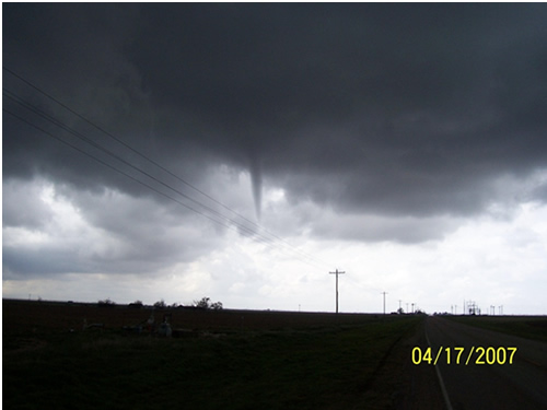
Photo of the Hale County funnel sighted just southwest of Plainview (image courtesy Deputy Baker and the Hale County Sheriff's Office).
For the second time this year the combination of a very cold mid-level low, plentiful moisture, and a surface boundary(s) resulted in numerous thunderstorms, some which produced funnel clouds and brief landspout tornadoes. The first event which produced similar weather occurred back on March 25th.
A brief bout of severe weather brought large hail, flooding, and tornadoes to the South Plains region on Tuesday the 17th. Numerous thunderstorms developed over the area as a closed mid level low approached from the west around midday, and persisted into the afternoon hours. The storms initially developed along and near several low level boundaries, including a weak stationary front that was stretched from northwest to southeast across the area. This front, coupled with very cold temperatures aloft and sufficient moisture, enhanced the potential for tornadoes.
To view a preliminary local storm report that includes details on reports of tornadoes and severe hail received by WFO Lubbock CLICK HERE. Keep in mind that these reports are preliminary and are subject to change. For a more complete explanation of the Preliminary Storm Reports continue on reading.
The first report of severe weather was received by the National Weather Service (NWS) in Lubbock shortly before noon, when a funnel cloud was sighted just southwest of Plainview (Hale County). A photo of the funnel can be seen at the top of this page - courtesy Deputy Baker and the hale County Sheriff's Office.
NWS meteorologists anticipated that additional funnel clouds and perhaps brief tornadoes were likely to occur as the coverage and intensity of thunderstorms increased through the afternoon. A Special Weather Statement was issued to notify the public and local officials over a large portion of the South Plains of this potential at 12:03 pm (you can view the statement HERE).
Intensifying storms over the southwest portions of Lubbock, and over the northwestern portions of Lubbock County near Shallowater, prompted a Severe Thunderstorm Warning at 1:21 pm. This warning was based on the identification of a weak three-body scatter spike (WTBSS) approximately 20,000 feet above southwest Lubbock. The WTBSS can be used as an indicator of hail up to one inch in diameter, or signify copious amounts of smaller non-severe hail. Shortly after the warning was issued, the initial reports of a tornado between Roundup and Shallowater were received at 1:25 pm. Multiple reports indicated that the tornado intermittently touched the ground over open fields northwest of Shallowater between 1:25 and 1:35 pm. Based on these reports, a Tornado Warning was issued for Lubbock County at 1:34 pm, stating that "additional brief tornadoes are likely".
As the severe storms began to impact Lubbock, one inch diameter hail was reported in the southwestern portions of the city at 1:40 pm. Another storm quickly developed over northeastern Lubbock County and resulted in ping pong ball size hail at Idalou by 1:44 pm. hail completely covered the ground in portions of Lubbock, as seen below in a photo by Tasha Coalson courtesy KCBD-TV. In addition to the hail, urban flooding submerged a vehicle along the Loop 289 service road in south Lubbock.
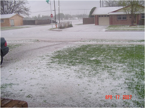 |
| Picture of hail in southwest Lubbock. The photo is by Tasha Coalson; courtesy KCBD-TV. |
Meanwhile a second tornado was photographed by a local broadcast media affiliate just west of Slaton. The tornado developed beneath a newly developed updraft along the previously discussed frontal boundary between 1:40 and 1:50 pm. Doppler radar indicated rotation within the developing storm. The below Doppler radar composite reflectivity image shows the Slaton storm developing. The surface observations are overlaid to show the proximity of the surface boundary and its wind shift.
 |
| Doppler radar composite reflectivity image shows the Slaton storm developing. The surface observations also are overlaid to show the proximity of the surface boundary and its wind shift. |
Brief tornadoes continued to develop beneath the evolving complex of storms over Lubbock County. One such tornado developed near the intersection of Quaker Avenue and U.S. Highway 84. This tornado blew the side panel off of a large metal structure and downed tree limbs. Winds associated with the tornado are estimated between 70 and 80 mph, ranked in the EF0 category on the Enhanced Fujita Scale for tornado intensity. A photo of the visible condensation funnel associated with this tornado can be seen below - courtesy Steve Smith via KCBD-TV.
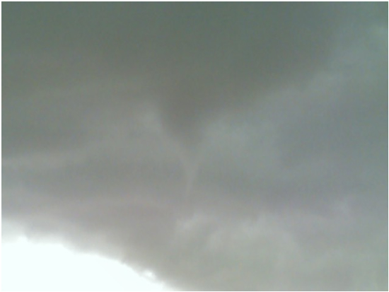 |
| A photo of the visible condensation funnel associated with the tornado that touched down near the intersection of Quaker Avenue and U.S. Highway 84. Photo courtesy Steve Smith via KCBD-TV. |
Another tornado was observed in an open field just southeast of Preston Smith Lubbock International Airport by a Texas Department of Public Safety Officer. The tornado was reported to be about 50 yards in width, and resulted in no damage as it moved south through open fields near the intersection of U.S. Highway 62/82 and Farm to Market Road 1729 between 2:03 and 2:04 pm.
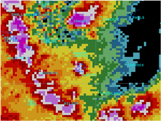
Perhaps the strongest tornado of the day occurred just southwest of Cotton Center (Hale County) between 1:57 and 2:03 pm. The tornado was associated with a small but intense radar signature with 80 knots of gate-to-gate rotation as seen in the below Doppler radar velocity image. A Tornado Warning was issued based on this signature at 2:03 pm. At least two large trees were uprooted and a center pivot irrigation system was blow over. The uprooted trees indicate wind speed estimated between 85 and 95 mph, and a rating of EF1. No structural damage was reported from this tornado.
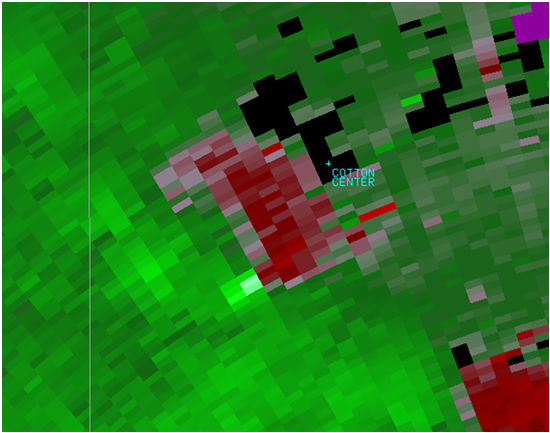 |
| Small but intense radar signature with 80 knots of gate-to-gate rotation seen in this Doppler radar velocity image at the time of a tornado just southwest of Cotton Center. |
The final severe storm to impact the South Plains on the 17th developed over northwestern portions of Garza County. Hail up to the size of nickels covered the ground along U.S. Highway 84 seven miles northwest of Post by 2:20 pm. A Severe Thunderstorm Warning was issued for northern Garza County by 2:21 pm. Snow plows were used to remove the hail from the driving surface. A resident in rural northern Garza County photographed a brief tornado ten miles north of Post at 2:30 pm. Hail also continued to accompany the storm eastward over northern Garza County, with penny size hail reported twelve miles north of Post by 2:42 pm. No damage was reported in Garza County.
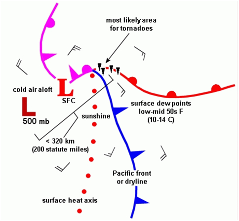
The meteorological situation that lead to Tuesday's severe storms was similar to the conceptual model for tornado cases associated with the cold core of an upper level low as discussed in a Weather and Forecasting manuscript by Jon Davies in 2006.
 |
|
Cold Core Tornado Model
|
 |
|
Tuesday's Weather Map and Funnels/Tornadoes
|
The NWS Storm Prediction Center recognized the potential for tornadoes in this environment by early Tuesday morning, and highlighted the central and southeast portions of the South Plains in a 5% tornado probability area tornado forecast.
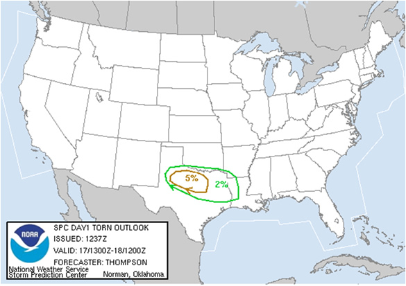 |
| Tornado probabilities issued by the NWS Storm Prediction Center early Tuesday morning. |
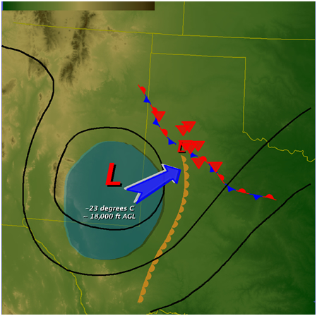
The center of Tuesday’s large scale upper level storm system contained an intense cold pool with temperatures as low as -23 degrees C between 15,000 and 20,000 feet above the ground . This contributed to very steep lapse rates and strong low-level instability, as surface temperatures rose into the 60s. As storms developed and encountered the pre-existing frontal boundary stretched across the area, the strong low-level instability contributed to intense updrafts that stretched ambient circulations across the boundary into brief tornadoes. These tornadoes, referred to as “nonmesocyclonic” tornadoes since they are not associated with the mesocyclonic rotation of a supercell thunderstorm, are usually weak but have been known to produce damage up to EF2 intensity.
The latest research and literature strongly discourages the use of terms such as “low energy funnel/tornado”, “cold air funnel/tornado”, or even “landspout” to describe nonmesocyclonic tornadoes. Regardless of the meteorological formative causes, these events are by definition tornadoes; a violent rotating column of air, in contact with the ground, either pendant from a cumuliform cloud or underneath a cumuliform cloud, and often (but not always) visible as a funnel cloud. Although the threat posed by these events can generally be differentiated from supercellular tornadoes that have the potential to produce violent damage, weak to strong nonmesocyclonic tornadoes can present a threat to life and property.

