NWS Birmingham, Alabama
Weather Forecast Office
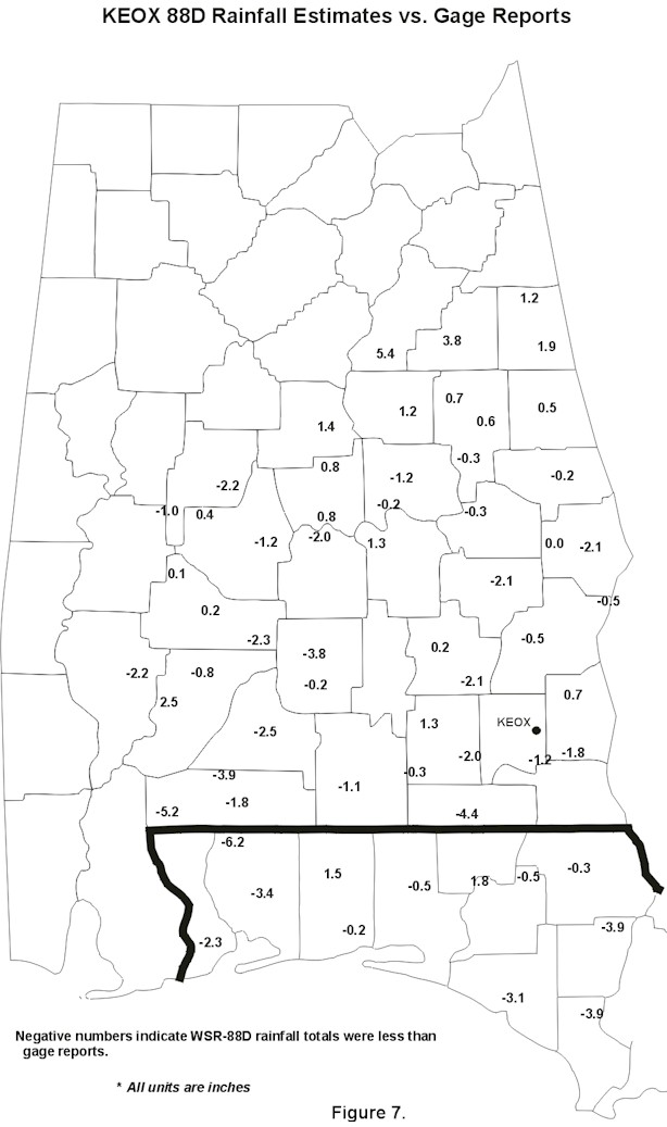
KEOX Rainfall Estimates vs. Gage Reports
| Figure 7: The KEOX radar showed a slightly negative bias, with radar estimated totals lower than gage totals at 61% of the stations. Negative and positive numbers appear to be evenly dispersed throughout the radar umbrella, except for two areas. An area over southwest Alabama, just west of the maximum rainfall, shows mostly negative values. This would likely be caused by the radar beam energy being absorbed by the heavy rainfall. Another area is located north-northwest of the radar near the 125 nmi. range limit. Radar estimates of six inches or more were not supported by gage reports or other radar estimates. |
 |
Current Hazards
National Outlooks
Tropical
Local Storm Reports
Public Information Statement
Graphical Hazardous Weather Outlook
Current Conditions
Regional Weather Roundup
Rivers and Lakes
Drought Monitor
Forecasts
Forecast Discussion
Air Quality
Fire Weather
Aviation Weather
Graphical Forecasts
Climate and Past Weather
Past Events
Storm Data
Tornado Database
Daily Rainfall Plots
Tropical Cyclone Reports
Warnings and Other Products
Tornado Warnings
Severe Thunderstorm Warnings
Flash Flood Warnings
Winter Weather Warnings
Special Weather Statements
Non-Precipitation Warnings
Flood/River Flood Warnings
Productos en Español
Conciencia y Preparación
Previsión de 7 Días
Weather Safety
NOAA Weather Radio
Severe Weather Preparedness
Severe Safety Rules
Tornado Safety Rules
Severe Safety w/ ASL
Awareness Weeks
Severe Weather
Hurricane Preparedness
Summer Safety Campaign
Winter Weather
US Dept of Commerce
National Oceanic and Atmospheric Administration
National Weather Service
NWS Birmingham, Alabama
465 Weathervane Road
Calera, AL 35040
205-664-3010
Comments? Questions? Please Contact Us.

