A hourly weather graph forecast can be generated by going to the Hourly Graph website.
Guide to decoding the forecast below.
311
FNUS81 KBGM 261001
FWMBGM
FCST,301011,241226,13,2,34,70,1,1,S,02,,36,21,96,64,0,0,N
FCST,301011,241227,13,2,39,70,1,1,S,05,,41,20,100,66,0,0,N
FCST,301011,241228,13,2,44,85,1,1,S,06,,45,30,96,65,0,0,N
FCST,301011,241229,13,6,52,85,1,1,S,09,,53,39,100,76,0,8,N
FCST,301011,241230,13,2,47,71,1,1,WSW,06,,55,40,100,68,15,0,N
FCST,301011,241231,13,2,45,68,1,1,SSE,06,,49,31,96,65,0,0,N
FCST,301011,250101,13,2,42,76,1,1,W,08,,47,36,100,63,0,0,N
FCST,300171,241226,13,1,28,71,1,1,SSE,02,,29,4,100,63,0,0,N
FCST,300171,241227,13,2,34,75,1,1,S,04,,35,11,100,66,0,0,N
FCST,300171,241228,13,2,40,88,1,1,S,06,,41,26,96,69,0,0,N
FCST,300171,241229,13,6,48,89,1,1,SSE,10,,49,37,100,82,0,8,N
FCST,300171,241230,13,2,44,81,1,1,W,08,,51,39,100,79,16,7,N
FCST,300171,241231,13,2,42,70,1,1,SSE,05,,46,31,100,67,0,0,N
FCST,300171,250101,13,2,39,82,1,1,W,08,,45,34,100,65,0,0,N
FCST,361802,241226,13,1,33,59,1,1,ENE,01,,35,12,100,55,0,0,N
FCST,361802,241227,13,2,37,65,1,1,SSW,02,,38,13,100,56,0,0,N
FCST,361802,241228,13,2,40,91,1,1,S,02,,41,26,100,62,0,0,N
FCST,361802,241229,13,6,50,92,1,1,SSE,04,,52,35,100,82,0,6,N
FCST,361802,241230,13,2,51,79,1,1,WNW,05,,54,41,100,77,16,3,N
FCST,361802,241231,13,2,47,69,1,1,SE,03,,52,30,100,65,0,0,N
FCST,361802,250101,13,2,45,79,1,1,WNW,05,,49,35,100,65,0,0,N
FCST,360791,241226,13,1,31,70,1,1,WNW,02,,32,6,100,69,0,0,N
FCST,360791,241227,13,2,36,72,1,1,SSW,03,,36,17,100,66,0,0,N
FCST,360791,241228,13,2,40,94,1,1,S,05,,41,27,100,69,0,0,N
FCST,360791,241229,13,6,48,96,1,1,SSE,10,,49,37,100,85,0,6,N
FCST,360791,241230,13,2,46,83,1,1,WNW,09,,51,41,100,82,15,0,N
FCST,360791,241231,13,2,43,74,1,1,SSE,06,,47,31,100,73,0,0,N
FCST,360791,250101,13,2,40,87,1,1,WNW,10,,44,35,100,70,0,0,N
FCST,360792,241226,13,1,34,67,1,1,NNW,01,,35,14,100,64,0,0,N
FCST,360792,241227,13,2,38,71,1,1,SSW,02,,39,18,100,64,0,0,N
FCST,360792,241228,13,2,43,92,1,1,S,04,,45,28,100,64,0,0,N
FCST,360792,241229,13,6,51,94,1,1,S,08,,54,37,100,82,0,6,N
FCST,360792,241230,13,2,49,77,1,1,W,06,,57,42,100,74,15,0,N
FCST,360792,241231,13,2,46,72,1,1,SSE,05,,52,32,96,68,0,0,N
FCST,360792,250101,13,2,43,82,1,1,W,08,,50,36,100,65,0,0,N
FCST,360151,241226,13,2,33,71,1,1,S,01,,34,14,100,65,0,0,N
FCST,360151,241227,13,2,38,73,1,1,S,03,,39,18,100,66,0,0,N
FCST,360151,241228,13,2,45,86,1,1,S,05,,46,29,100,67,0,0,N
FCST,360151,241229,13,6,51,94,1,1,S,08,,52,39,100,79,0,8,N
FCST,360151,241230,13,2,48,77,1,1,W,05,,55,41,100,74,15,0,N
FCST,360151,241231,13,2,46,70,1,1,SSE,05,,50,32,100,68,0,0,N
FCST,360151,250101,13,2,43,81,1,1,W,06,,47,36,100,65,0,0,N
FCST,361031,241226,13,1,33,61,1,1,SE,02,,34,6,100,54,0,0,N
FCST,361031,241227,13,2,36,68,1,1,S,02,,37,13,100,58,0,0,N
FCST,361031,241228,13,2,39,95,1,1,S,02,,41,25,100,64,0,0,N
FCST,361031,241229,13,6,49,95,1,1,SSE,05,,50,35,100,89,0,0,N
FCST,361031,241230,13,2,50,79,1,1,WNW,06,,52,40,100,77,16,3,N
FCST,361031,241231,13,2,46,69,1,1,SE,05,,50,30,100,68,0,0,N
FCST,361031,250101,13,2,44,79,1,1,WNW,08,,47,35,100,65,0,0,N
FCST,300971,241226,13,2,29,81,1,1,S,04,,30,20,92,68,0,0,N
FCST,300971,241227,13,2,35,84,1,1,SSE,08,,35,18,100,78,0,0,N
FCST,300971,241228,13,2,40,95,1,1,S,11,,41,30,100,78,0,0,N
FCST,300971,241229,13,6,47,98,1,1,SSE,13,,48,38,100,92,0,8,N
FCST,300971,241230,13,2,43,85,1,1,WSW,10,,49,40,100,82,15,0,N
FCST,300971,241231,13,2,41,81,1,1,SSE,10,,44,32,100,79,0,0,N
FCST,300971,250101,13,2,38,89,1,1,W,11,,42,35,100,76,0,0,N
995
FNUS51 KBGM 261000
FWFBGM
Fire Weather Planning Forecast for Central NY/Northeast PA
National Weather Service Binghamton NY
500 AM EST Thu Dec 26 2024
.SYNOPSIS...
High pressure will dominate our weather today through Friday with
seasonable temperatures and no precipitation. A storm system
approaching the area may bring a brief period of light freezing
rain to parts of the area early Saturday, before changing to
light rain. A steadier rainfall is expected Sunday into Monday,
which may result in river rises and localized flooding.
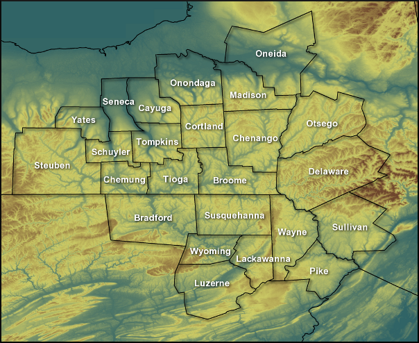
NYZ210-262100-
Leatherstocking-
500 AM EST Thu Dec 26 2024
Today Tonight Fri
Cloud Cover Pcldy Pcldy Pcldy
Precip Type None None None
Chance Precip (%) 0 0 0
Temp (24h trend) 30 (+3) 10 (+2) 37
RH % (24h trend) 51 (+22) 100 (0) 56
20ft Wnd-Val/AM(mph) Lgt/Var Lgt/Var
20ft Wnd-Rdg/PM(mph) Lgt/Var Lgt/Var Lgt/Var
Precip Amount 0.00 0.00 0.00
Precip Duration
Precip Begin
Precip End
Mixing Hgt(ft-agl/msl)1670 1210
Transport Wnd (mph) SW 5 S 6
Vent Rate (kt-ft) 15250 13820
DSI 1 1
Sunshine Hours 5 4
LAL No tstms No tstms No tstms
Haines Index 4 4 3
ADI early 5 Very Poor 3 Very Poor 6 Very Poor
ADI late 8 Poor 3 Very Poor 7 Poor
Max LVORI early 9 9 9
Max LVORI late 5 10 4
Remarks: ADI is Atmospheric Dispersion Index by Lavdas.
LVORI is Low Visibility Occurrence Risk Index.
.FORECAST FOR DAYS 3 THROUGH 7...
.SATURDAY...Mostly cloudy with a 50 percent chance of rain
showers and freezing rain. Lows in the mid 20s. Highs in the
lower 40s. East winds around 5 mph.
.SUNDAY...Rain. Lows in the upper 30s. Highs around 50. Chance of
rain 90 percent. East winds 5 to 10 mph.
.MONDAY...Rain. Lows in the upper 30s. Highs in the upper 40s.
Chance of rain 90 percent. Southeast winds 5 to 10 mph.
.TUESDAY...Mostly cloudy with a 30 percent chance of rain
showers. Lows in the lower 30s. Highs in the mid 40s. Northeast
winds around 5 mph.
.WEDNESDAY...Mostly cloudy with rain and snow showers likely.
Lows in the mid 30s. Highs around 40. Chance of precipitation
70 percent. East winds 5 to 10 mph.
$$
PAZ038-039-043-262100-
Bradford-Susquehanna-Wyoming-
Including the cities of Sayre, Towanda, Hallstead, Montrose,
and Tunkhannock
500 AM EST Thu Dec 26 2024
Today Tonight Fri
Cloud Cover Pcldy Pcldy Pcldy
Precip Type None None None
Chance Precip (%) 0 0 0
Temp (24h trend) 34 (+4) 15 (+2) 38
RH % (24h trend) 64 (+6) 100 (0) 67
20ft Wnd-Val/AM(mph) Lgt/Var Lgt/Var
20ft Wnd-Rdg/PM(mph) Lgt/Var Lgt/Var Lgt/Var
Precip Amount 0.00 0.00 0.00
Precip Duration
Precip Begin
Precip End
Mixing Hgt(ft-agl/msl)1840 1330
Transport Wnd (mph) SW 5 S 7
Vent Rate (kt-ft) 12730 12990
DSI 1 1
Sunshine Hours 4 3
LAL No tstms No tstms No tstms
Haines Index 4 3 3
ADI early 6 Very Poor 3 Very Poor 6 Very Poor
ADI late 9 Poor 3 Very Poor 9 Poor
Max LVORI early 7 10 9
Max LVORI late 5 10 4
Remarks: ADI is Atmospheric Dispersion Index by Lavdas.
LVORI is Low Visibility Occurrence Risk Index.
.FORECAST FOR DAYS 3 THROUGH 7...
.SATURDAY...Mostly cloudy with rain showers likely and a chance
of freezing rain. Lows in the upper 20s. Highs in the mid 40s.
Chance of precipitation 70 percent. Southeast winds around 5 mph.
.SUNDAY...Rain. Lows in the upper 30s. Highs in the lower 50s.
Chance of rain 90 percent. Southeast winds 5 to 10 mph.
.MONDAY...Rain. Lows around 40. Highs in the upper 40s. Chance of
rain 90 percent. South winds 5 to 10 mph.
.TUESDAY...Mostly cloudy. A 30 percent chance of rain showers.
Lows in the lower 30s. Highs in the mid 40s. Southeast winds
around 5 mph.
.WEDNESDAY...Mostly cloudy with rain showers likely and a chance
of snow showers. Lows in the mid 30s. Highs in the lower 40s.
Chance of precipitation 70 percent. Southeast winds around 5 mph.
$$
PAZ044-047-262100-
Lackawanna-Luzerne-
Including the cities of Scranton, Hazleton, and Wilkes-Barre
500 AM EST Thu Dec 26 2024
Today Tonight Fri
Cloud Cover Pcldy Pcldy Pcldy
Precip Type None None None
Chance Precip (%) 0 0 0
Temp (24h trend) 35 (+4) 17 (+5) 39
RH % (24h trend) 61 (+11) 100 (0) 62
20ft Wnd-Val/AM(mph) Lgt/Var Lgt/Var
20ft Wnd-Rdg/PM(mph) Lgt/Var Lgt/Var Lgt/Var
Precip Amount 0.00 0.00 0.00
Precip Duration
Precip Begin
Precip End
Mixing Hgt(ft-agl/msl)2060 1590
Transport Wnd (mph) W 3 SW 6
Vent Rate (kt-ft) 9330 10610
DSI 1 1
Sunshine Hours 6 4
LAL No tstms No tstms No tstms
Haines Index 4 4 3
ADI early 7 Poor 3 Very Poor 7 Poor
ADI late 8 Poor 3 Very Poor 8 Poor
Max LVORI early 9 9 9
Max LVORI late 4 9 4
Remarks: ADI is Atmospheric Dispersion Index by Lavdas.
LVORI is Low Visibility Occurrence Risk Index.
.FORECAST FOR DAYS 3 THROUGH 7...
.SATURDAY...Mostly cloudy with rain showers and freezing rain
likely. Lows in the upper 20s. Highs in the mid 40s. Chance of
precipitation 70 percent. Southeast winds around 5 mph.
.SUNDAY...Rain. Lows in the upper 30s. Highs in the mid 50s.
Chance of rain 90 percent. Southeast winds around 5 mph.
.MONDAY...Rain. Lows in the lower 40s. Highs in the lower 50s.
Chance of rain 90 percent. South winds 5 to 10 mph.
.TUESDAY...Mostly cloudy. A 30 percent chance of rain showers.
Lows in the lower 30s. Highs in the upper 40s. Northeast winds
around 5 mph.
.WEDNESDAY...Mostly cloudy with rain showers likely and a chance
of snow showers. Lows in the mid 30s. Highs in the lower 40s.
Chance of precipitation 70 percent. East winds around 5 mph.
$$
PAZ040-048-072-262100-
Northern Wayne-Pike-Southern Wayne-
Including the cities of Damascus, Equinunk, Milford,
and Honesdale
500 AM EST Thu Dec 26 2024
Today Tonight Fri
Cloud Cover Mclear Mclear Pcldy
Precip Type None None None
Chance Precip (%) 0 0 0
Temp (24h trend) 33 (+3) 12 (+2) 36
RH % (24h trend) 56 (+1) 100 (0) 62
20ft Wnd-Val/AM(mph) Lgt/Var Lgt/Var
20ft Wnd-Rdg/PM(mph) Lgt/Var Lgt/Var Lgt/Var
Precip Amount 0.00 0.00 0.00
Precip Duration
Precip Begin
Precip End
Mixing Hgt(ft-agl/msl)1770 1320
Transport Wnd (mph) NW 5 SW 5
Vent Rate (kt-ft) 8400 9290
DSI 1 1
Sunshine Hours 7 4
LAL No tstms No tstms No tstms
Haines Index 4 4 3
ADI early 6 Very Poor 2 Very Poor 6 Very Poor
ADI late 8 Poor 3 Very Poor 7 Poor
Max LVORI early 9 10 9
Max LVORI late 4 10 4
Remarks: ADI is Atmospheric Dispersion Index by Lavdas.
LVORI is Low Visibility Occurrence Risk Index.
.FORECAST FOR DAYS 3 THROUGH 7...
.SATURDAY...Mostly cloudy with rain showers likely and a chance
of freezing rain. Lows in the mid 20s. Highs in the lower 40s.
Chance of precipitation 70 percent. Southeast winds around 5 mph.
.SUNDAY...Rain. Lows in the mid 30s. Highs in the lower 50s.
Chance of rain 90 percent. Southeast winds around 5 mph.
.MONDAY...Rain. Lows around 40. Highs around 50. Chance of rain
90 percent. South winds 5 to 10 mph.
.TUESDAY...Mostly cloudy. A slight chance of rain showers. Lows
in the lower 30s. Highs in the mid 40s. North winds around 5 mph.
.WEDNESDAY...Mostly cloudy with rain and snow showers likely.
Lows in the mid 30s. Highs in the lower 40s. Chance of
precipitation 70 percent. Northeast winds around 5 mph.
$$