
Showers, along with a few strong to severe thunderstorms, are expected from the Great Lakes, New England and southward into the Ohio and Tennessee Valleys. In the wake of this system, a stronger storm is expected to track from the Pacific Northwest, Plains and through the Eastern U.S. this weekend. Strong winds, showers and a larger drop in temperatures are expected this weekend into Monday. Read More >
|
Isolated Early Morning Activity - Straight Line Wind Damage In the early morning hours on February 28th, 2011 a line of showers and strong thunderstorms were ongoing across northwestern portions of Alabama. This activity developed along a pre-frontal boundary (trough axis) extending southwest from Kentucky ahead of an approaching cold front. Most of these storms produced primarily moderate to heavy rainfall and gusty winds. However, one storm along this boundary prompted a severe thunderstorm warning at 8:23 am. This storm had a pronounced bow shape as it pushed from northwestern Mississippi into northwestern Colbert and western Lauderdale county. Over the next few hours, this boundary pushed further northeast and affected Tennessee counties just northwest of the Huntsville Forecast area (Wayne, Lawrence, Giles, Lewis, Marshall, Bedford, Coffee, etc) with severe thunderstorms, some producing possible tornadoes. |
|
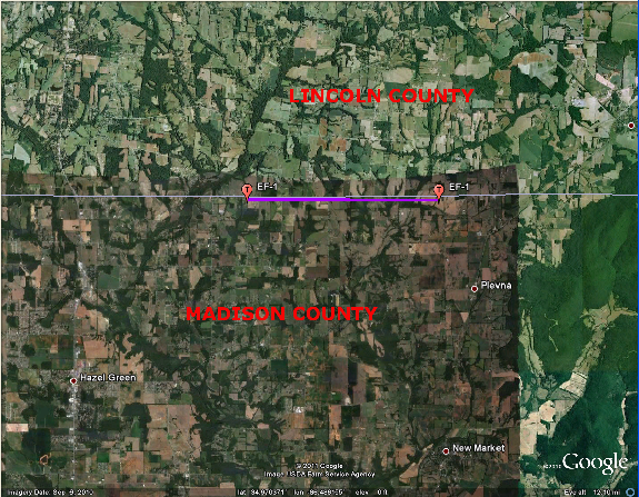
Late Morning and Early Afternoon Hours - Tornadoes Some breaks in the cloud cover ahead of the final squall line of the day and continued strong, moist southerly flow from the Gulf of America increased instability into the early afternoon hours. Some dry air aloft pushing in behind this squall line also helped to increase the damaging wind threat during this time. A line of severe thunderstorms developed along this line as it pushed into northwestern Alabama after 10:30 am. These severe thunderstorms continued east producing wind damage across much of northwestern and north central Alabama. Around noon, increased instability combined with strong wind shear as this line pushed into Madison county in northern Alabama and Moore and Franklin counties in Tennessee to produce two tornadoes. The strongest tornado began at just southeast of Lynchburg, TN and moved east northeast to the edge of Woods Reseviour northeast of the Estill Springs community before lifting. This tornado was rated an EF-2 tornado with maximum wind speeds of 125 mph and had a path length of 11.0 miles. Tragically, one person was killed and 4 were injured by this tornado. A weaker tornado also developed in northern Madison county. This was an EF-1 tornado with maximum wind speeds of 95 mph. Additional damaging wind reports were received in northeastern Alabama as this line continue east and pushed into Georgia through 3 pm. |
|
Confirmed Tornado Paths... |
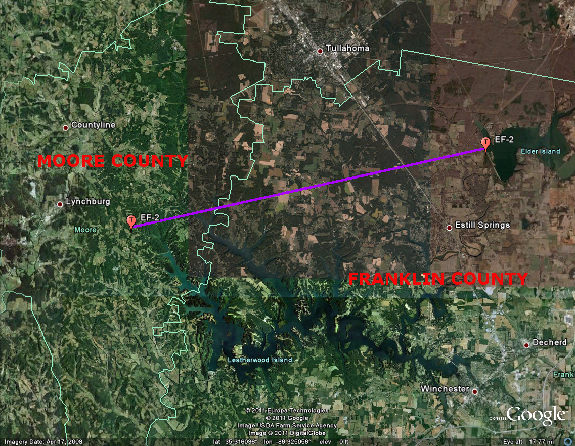
Track in extreme eastern Moore (just southeast of Lynchburg, TN) into the Estill Springs area of Franklin County Tennessee (click on a track for detailed information about the tornado). |
|
Track in northern Madison and northwestern Jackson counties (click on the track for detailed information on each tornado). Click here to see a list of storm reports from this severe weather event. |
 |
 |


 Local Radar
 Weather Map