National Weather Service United States Department of Commerce

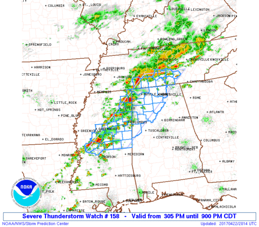
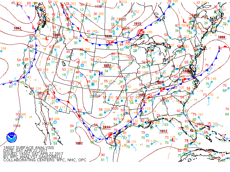
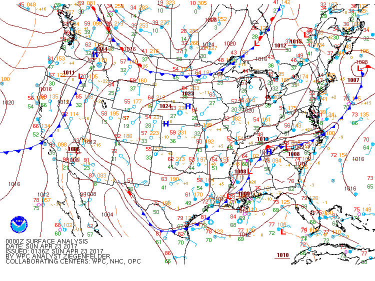
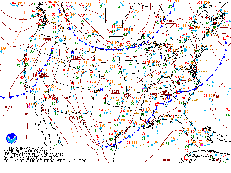
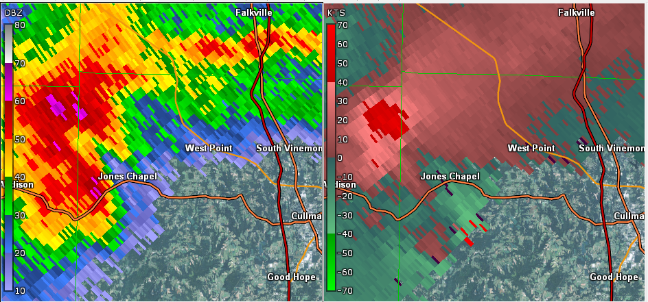
An upper level trough and associated low pressure system tracked eastward across the southern United State during the day on April 22nd. This pushed a strong cold front southeastward and into the Lower Mississippi Valley by that afternoon, with a warm front remained draped across northern Mississippi and through central Tennessee. Ahead of the cold front, southerly flow advected warm and moist air into the TN Valley and helped the atmosphere become unstable. Showers and thunderstorms developed across Mississippi in response to the unstable environment and enhanced by the lift associated with the cold front. As these storms pushed eastward, surface winds across northern Alabama shifted to the southeast and increased the low level wind shear across the area. Given the instability in place and the increased wind shear, isolated thunderstorms developed into supercells and moved east across portions of the area. One supercell produced a tornado in Mississippi, which tracked into Franklin County, AL. While this tornado lifted shortly after entering the state, the same storm produced another tornado in western Cullman County. Another supercell moved across Lincoln County, TN and produced a swath of quarter to golf ball sized hail. As this storm moved into Jackson County, AL, it produced a weak tornado. Elsewhere, thunderstorms produced sporadic wind damage and quarter sized hail.


Storm Reports
Severe Thunderstorms Watch #158 was issued at 3:05 PM. Click the radar loop to view the storm reports.


Tornado - RED BAY AL
Franklin County, AL 

Click here for more details.

Date April 22, 2017
Time (Local) 331 PM CDT
EF Rating EF-0
Est. Peak Winds 75 mph
Path Length 5.6 miles
Max Width 200 yards
Injuries/Deaths 0

Summary:

 An EF-0 tornado touched down just west of the 
 MS/AL state line. It tracked eastward  crossing 
 into Franklin County, AL before  lifting  near 
 Franklin County Road 23. Damage  associated 
 with  this tornado was mainly  small to 
 medium sized  trees snapped and a  couple of 
 trees uprooted. 


Tornado - JONES CHAPEL AL
Cullman County, AL

Click here for more details.

Date April 22, 2017
Time (Local) 5:40 PM CDT
EF Rating EF-1
Est. Peak Winds 100 mph
Path Length 4.39 miles
Max Width 200 yards
Injuries/Deaths 0

Summary:

 An EF-1 tornado touched down near the 
 intersection of CR 1043 and CR 1047, where
 roof damage to a farm hours was noted. The 
 tornado continued in a generally SSE direction, 
 uprooting several trees and damaging a farm 
 structure. Several chicken houses were several 
 damaged as the tornado continued its path, 
 before lifting near the intersection of CR 991
 and 992. 


Tornado - SKYLINE AL
Jackson County AL

Click here for more details.

Date April 22, 2017
Time (Local) 5:40 PM CDT
EF Rating EF-0
Est. Peak Winds 85 mph
Path Length 2.19 miles
Max Width 200 yards
Injuries/Deaths 0

Summary:

 An EF-0 tornado touched down in approx. 2 
 miles SW of Skyline Alabama.  The tornado 
 continued in an eastward direction and snapped 
 or uprooted several trees as it crossed Manning 
 Drive. A few more trees were uprooted just east
 of CR 79 before the tornado lifted in the
 vicinity of Gizzard Point Drive. 

 
Back to the Top of the Page

Upper Air Charts

250mb Chart at 7am April 22nd

500mb Chart at 7am April 22nd

850mb Chart at 7am April 22nd

250mb Chart at 7pm April 22nd

500mb Chart at 7pm April 22

850mb Chart at 7pm April 22nd

Back to the Top of the Page

Surface/Mesoscale Anaylsis

7am April 22nd

10am April 22nd

1pm April 22nd

4pm April 22nd 7pm April 22nd 10pm April 22nd
Back to the Top of the Page

SPC Outlooks

Day 3 Outlook 
Issued  230am April 20th


Day 2 Outlook 
Issued 11:30 am April 21st

Day 1 Outlook
Issued  1030 am April 22nd

Day 1 Tornado Probability
Issued 1030 am April 22nd

Day 1 Wind Probability
Issued 1030 am April 22nd

Day 1 Hail Probability
Issued 1030 am April 22nd

Back to the Top of the Page

Radar

tr>
KGWX radar at 3:29 PM; approximately 1 minute after the Red Bay tornado crossed into Alabama from Mississippi. KOHX radar at 5:39 PM; approximately 1 minute after the Jones Chapel tornado touched down.
KOHX radar at 5:41 PM; approximately 1 minute after the Skyline tornado touched down.
Back to the Top of the Page

Event Images


Trees were snapped or uprooted in Phil Campbell. The damage was the result of a microburst. (NWS Storm Survey)

Several trees were snapped along the damage path caused by the Franklin County EF-0 tornado. (NWS Storm Survey)

A chicken house sustained damage from the Cullman County EF-1 tornado. (NWS Storm Survey)

A large metal building also sustained damage from the Cullman County EF-1 tornado. (NWS Storm Survey)

Several trees were uprooted along the Skyline EF-0 tornado path in Jackson County, AL (NWS Storm Survey)
 
Back to the Top of the Page