
Gusty winds and dry conditions will promote elevated to critical fire weather conditions across the southern Plains and southern Rockies. A cold front will linger over Florida through Tuesday, bringing widespread showers and thunderstorms, and potential flash flooding concerns. Showers and thunderstorms will be most widespread across eastern and central Florida. Read More >
Houston/Galveston, TX
Weather Forecast Office
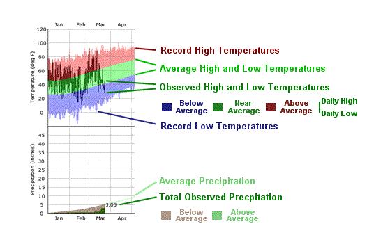
You are at NWS Houston/Galveston » SE TX Climate » Houston Climate» Climate Graphs - IAH
CURRENT HAZARDS
-National Hurricane Center
-Storm Prediction Center
-Weather Prediction Center
-River Forecast Centers
-Aviation Weather Center
-Center Weather Service Units
-Spaceflight Meteorology Group
-Space Weather Prediction Center
CURRENT WEATHER
-Tides and Currents
-Observations
-Satellite
-Rainfall Reports
-Public Information Statement
-Galveston Beach Patrol (Flag Warning System)
FORECASTS
-Activity Planner
-Forecast Discussion
-Marine
-Tropical
-Aviation
-Fire
-Beach
-Models
-Drought
History
-Our Office
-National Weather Service
-NOAA
-Major Events
RADAR
-Houston/Galveston
-National
-Corpus Christi
-Lake Charles
-Austin/San Antonio
-Granger (Central Texas)
-Worldwide
-Education
Rivers/Lakes/Bayous
-Lower Colorado River Authority
-Harris County Flood Warning System
-Local
-National
-Jefferson County Drainage District 6
-Brazos River Authority
CLIMATE
-Houston Intercontinental
-Houston Hobby
-Galveston
-College Station
-Palacios
-Graphs
-Climate Summaries
-Local Data/Records
-Old Climate Page
-NCEI
-Storm Data
-Weather History
-Wind Roses
Education/Careers
-National Weather Service
-Careers
-Web Weather for Kids
-HGX Teacher Resources
-more
PREPAREDNESS/SAFETY
-Evacuation Planning
-Publications/Brochures
-StormReady
-2025 Hurricane Guide
-2025 Hurricane Guide (Spanish)
-SKYWARN Schedule
-FloodAware
-Weather Radio
-Evacuation ZipZone
-Evacuation Routes
-more
ADDITIONAL INFO
-Weather Ready Nation
-Weather Safety
-Severe Stats
-Air Now
-CoCoRaHS
-Miscellaneous Info
-Astronomical Info
-Frequent Products
-Find It Quick
-Watch, Warning, and Advisory Criteria
Tropical
-Preparedness Meetings
-Historical Tracks
-Education
-Climatology for SE TX
-Hurricane Harvey
-Hurricane Alicia
-Tropical Storm Imelda
-Local Page
US Dept of Commerce
National Oceanic and Atmospheric Administration
National Weather Service
Houston/Galveston, TX
1353 FM 646 Suite 202
Dickinson, TX 77539
281-337-5074
Comments? Questions? Please Contact Us.

