Tropical Depression Two is currently drifting north-northwestward in the eastern Gulf, and is expected to become a tropical storm in the northeastern Gulf by tomorrow or Tuesday.
A westward motion is expected by Wednesday, bringing the system towards SE Texas by Thursday-Friday.
Highly uncertain track / intensity forecast beyond Wednesday. Hurricane Hunter reconnaissance aircraft flew into this system earlier today and aided in determining the current central pressure and maximum sustained winds.
Tropical Storm force winds could arrive in our coastal waters as early as Wednesday night with increasing chances for rain and thunderstorms Thursday-Friday across SE Texas.
Confidence on expected impacts and timing will increase over the next couple of days as additional data become available.


 Local Radar
 Weather Map
 TX Satellite Imagery
 Monthly Hydrologic Reports
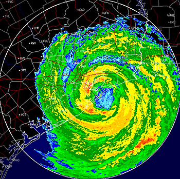 Hurricane Preparedness
 CONUS Satellite Imagery
 Climate Graphs
 Climate Summaries