
Dry fuels, strong winds and dry weather will continue to bring elevated to critical fire weather conditions to the areas of the Plains, Midwest and Southeast today. A Pacific storm system will bring low elevation rain and heavy high elevation mountain snow to California through early week, expanding into the Pacific Northwest, Great Basin, and southern California on Tuesday. Read More >

Fig. 1. A “shelf cloud,” representing the leading edge of air spreading horizontally away from a thunderstorm downdraft. Wind gusts of 60 mph or more would likely be experienced along the leading edge and just to the rear of this cloud formation.
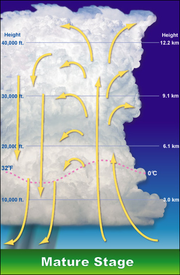
Fig. 2. Schematic of a mature thunderstorm, depicting the updraft (yellow arrows pointing toward top of the page) and the downdraft
A thunderstorm may eventually grow to a height of 50,000 feet or more before it stops developing. Generally speaking, the “taller” the storm, the more likely it is to produce violent weather.
Thunderstorms are characterized in two ways: general and severe. A Severe thunderstorm is one that produces large hail (i.e., one-inch diameter or larger), damaging wind gusts, and/or tornadoes.


 Hourly Weather