
Strong to severe thunderstorms may produce heavy to excessive rainfall over portions of the Central/Southern Plains and Mississippi Valley today. There is a Slight Risk (Level 2 of 4) for Excessive Rainfall and a Slight Risk (Level 2 of 5) for severe thunderstorms today. Elevated fire weather conditions are possible over parts of western Florida today. Read More >
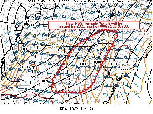
MESOSCALE DISCUSSION 0637
NWS STORM PREDICTION CENTER NORMAN OK
0541 PM CDT WED APR 27 2011

AREAS AFFECTED...PARTS OF ERN AL...NRN/CENTRAL GA...AND WRN NC/SC

CONCERNING...SEVERE POTENTIAL...TORNADO WATCH LIKELY

VALID 272241Z - 272315Z

A NEW TORNADO WATCH IS BEING COORDINATED TO THE EAST OF WW/S 235 AND
238.  THIS NEW WATCH WILL LIKELY BE A PDS WATCH.

STRENGTHENING SLY LOW LEVEL WINDS /50-60 KT/ THIS EVENING ACROSS ERN
AL INTO CENTRAL/NRN GA TO WRN PARTS OF SC/NC WILL MAINTAIN A MOIST
AIR MASS /SURFACE DEWPOINTS RISING INTO THE MID 60S/ AND SUPPORTING
MLCAPE 1000-2000 J/KG.  THIS COMBINED WITH INCREASING SWLY MIDLEVEL
WINDS ATOP THE LOW LEVEL WINDS WILL SUPPORT STRONG EFFECTIVE BULK
SHEAR /50-70 KT/ FOR DISCRETE SUPERCELLS AS ACTIVITY NOW LOCATED
OVER AL AND ERN TN DEVELOPS DOWNSTREAM.

..PETERS.. 04/27/2011


ATTN...WFO...RNK...CAE...GSP...MRX...FFC...TAE...BMX...MOB...

LAT...LON   32358642 35008451 36218196 35998051 33778216 32098310
            31598390 31608645 32358642
|


 Current Conditions Map