
Unseasonably warm temperatures continue through the weekend across the Southwest and southern U.S., with more than 100 record or near record maximum temperatures forecast through the rest of the week and over the weekend. Elevated to critical fire weather conditions will persist across the Plains and Southeast U.S. this weekend. Read More >
|
The Greenville, South Carolina, Flash Flood of 29 July 2004
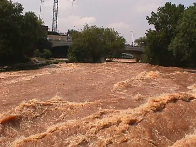
Flooding along the Reedy River through the west end section of downtown Greenville, South Carolina, on 29 July 2004. Author's Note: The following report has not been subjected to the scientific peer review process. 1. Introduction A record-setting flash flood developed over part of the Greenville, South Carolina, metro area during the morning of Thursday, July 29, 2004. When the event ended, 6 to 8 inches of rain had fallen just east of Berea, a northwestern suburb, and the Reedy River through downtown Greenville crested 9 ft above flood stage, its highest level since 1908. 2. Meteorological Setting Scattered rain showers began developing across upstate South Carolina in the pre-dawn hours of July 29, 2004. The western Carolinas had been in a persistent upslope flow regime for 24 hours, characterized by low- level easterly and southeast flow off the Atlantic Ocean. This pattern typically results in development of showers across the northern tier of upstate South Carolina and parts of western North Carolina with an east or southeast aspect, and in that regard, this meteorological event was fairly common. It is not unusual in such a synoptic setup to have showers and thunderstorms remain stationary. However, recent history had shown a tendency for cells to anchor along the Blue Ridge Escarpment (the northeast-to-southwest oriented rapid rise in elevation marking the transition from the Piedmont to the Blue Ridge Mountains), especially when upper level flow is weak as it was July 29th. Aside from upslope flow, a number of other factors contributed to this extreme rainfall event. At the surface, a frontal boundary was lifting slowly northward. This boundary, which had passed over the region earlier in the week, was retreating ahead of an upper level trough that was digging to the southeast from the northern plains. This boundary contributed in at least two ways to the potential for extreme rainfall; it served as a convergence mechanism, and it gave an upslope orientation to the low level flow. The surface front separated very moist air, with surface dewpoints in the lower to middle 70s, from relatively drier air across our northern zones, where dewpoints were in the lower to middle 60s. The flow aloft was weak, but upper air analysis and water vapor imagery showed a short wave approaching from the west. The 850 mb analysis at 1200 UTC (8:00 a.m. EDT)Thursday indicated 850 mb dewpoints of 14 OC to 16 OC over all of the southeast states, with trajectories pointing to a continued influx of very moist air into the forecast area. Soundings at 1200 UTC showed precipitable waters ranging from 1.52 inches at Peachtree City, Georgia (FFC), to 0.96 inches at Blacksburg, Virginia (RNK), and the LAPS sounding for Greenville at 1200 UTC indicated precipitable water of 1.63 inches. 3. Chronology of the Flood By 1240 UTC, showers around Greenville had merged to form a small convective cluster centered near Berea. Looping of the KGSP radar reflectivity imagery shows the cells merging into a stationary cluster about 6 miles wide (Fig. 1). Low level inflow into the system was also evident. The NWS LARC gage on the Reedy River off Westfield Street in downtown Greenville is programmed to call WFO GSP whenever the stage at that location reaches 6.0 feet, which it did at 1236 UTC. It rose rapidly to 7.5 ft. at 1243 UTC. Click to launch a 13-frame loop of radar imagery with controls. Radar rainfall estimates at that time were around two inches per hour just east of Berea, on the northwest side of Greenville. A Flood Statement was issued for Greenville and eastern Pickens counties at 1253 UTC, indicating that flood warnings may be required. The Reedy River gage in Greenville reached flood stage of 8 ft just before 1300 UTC. At this level flooding begins in Cleveland Park, which is a common occurrence and does not, in itself, warrant a flood warning. However, the Reedy River had risen more than 5 ft between 1200 UTC and 1300 UTC and the rise was expected to continue as the convective cluster remained stationary over the headwaters. A Flash Flood Warning was issued at 1304 UTC indicating that the river would crest well above flood stage. A call was made to Greenville County Emergency Management at 1310 UTC to advise them of the situation and to solicit information. At that time, no flooding had yet been reported. The first report of actual flooding away from flood-prone Cleveland Park was received by WFO GSP at 1353 UTC. The Parker District Fire Department reported Lewis Road and Old Cedar Lane Road closed, with evacuations underway for homes off Lily Street in Berea, where the Long Branch had left its banks. Water completely covered yards of homes closest to the creek. A shelter had been opened at a local church for the evacuees. An Amateur Radio operator reported an old fishing lake, off Lily Street near Lions Club Drive and Lora Lane, had overtopped its rim and he feared the dam might break with the flow of water coming out of the lake. In addition, urban flooding was becoming severe on some streets, with road closures on Cedar Lane Road, Pettis Road, and much-traveled White Horse Road. This information was included in the follow-up Flash Flood Statement, issued at 1437 UTC. Calls continued to be made to the downtown Reedy River gage. At 1439 UTC, the river level was 11.36 feet; at 1506 UTC, the stage had climbed to 12.21 feet. New flooding reports arrived, including stalled vehicles in flood waters at Cherrydale Point, a major commerce hub, and water on Lily Street was up to the roofs of some homes along Long Branch. Evacuations continued and Greenville County Emergency Management reported several swift water rescues. Flooding was reported in buildings on the campus of Furman University. The Flash Flood Warning for Greenville County was extended from 1600 UTC until 1900 UTC. In the meantime, the convective cluster that had been nearly stationary over the headwaters of the Reedy River for three hours finally began to weaken on its westward edge as the system expanded north and east. This shift resulted in the heavy rain axis moving to the headwaters of one of Greenville County's other flood-prone creeks, Brushy Creek. Up to this point, heavy rain had been concentrated over west central Greenville County, along with a brief but heavy downpour over downtown Greenville around mid morning. As heavy rain moved over the headwaters of Brushy Creek, on Greenville's east side, the NWS gage at Del Norte rose from 0.8 ft at 1500 UTC to 5.8 ft at 1700 UTC. The Reedy River, meanwhile, continued its rapid rise toward a crest of historical proportions, reaching 13.0 ft at 1530 UTC and 16.1 ft. at 1626 UTC. By 1730 UTC, rain had ended over the Reedy River basin. Radar estimates indicated storm total rainfall of 6 to 8 inches over the headwaters; an automated gage to the west of the radar-estimated maximum, measured 3.91 inches of rain. Reports collected after the storm confirmed that the maximum rainfall was about 8 inches. The Reedy River rose to its second highest level ever recorded by 1700 UTC, 16.84 feet, nearly 9 feet above flood stage. At that point the gage reached its maximum recording level and communications were lost. A post storm survey revealed that the water continued to rise and reached a depth of 19 ft 2 in, which completely submerged the gage. Heavy rain continued into early afternoon over headwaters of Brushy Creek. NWS personnel checked the Del Norte gage and observed the flooding there. Brushy Creek at Del Norte crested at 8.55 feet shortly before 1900 UTC. By this time, however, an outflow boundary emerged from the thunderstorm complex and the system finally weakened as it drifted to the east. Rain ended over Greenville County by 1930 UTC. However, radar showed that additional showers and thunderstorms had developed southeast of Greenville County, and they were heading toward the northwest. The location and movement of these storms indicated they might affect locations still experiencing flooding by early evening. A Flood Warning was issued for Greenville County at 1900 UTC with the anticipation that flood waters in Berea and west Greenville might not recede significantly by early evening, and also taking into account the slowing rise on Brushy Creek at Del Norte. By 2045 UTC, when a Flash Flood Statement for Greenville County was issued, flood waters had receded at Del Norte; the creek stage was down to 7.36 ft. Emergency Management confirmed that numerous flooded roads still existed in and around Berea. Another gage on the Reedy River, 6 miles downstream from downtown Greenville and adjacent to Interstate 85 mile marker 46, showed a rise to over 11 feet in less than 2 hours' time. This confirmed that the flood crest was progressing down the Reedy, with the expectation that flood conditions may reach Fork Shoals in the evening. The upslope-induced convection that developed southeast of Greenville County was showing no signs of weakening as evening approached, and it was drifting toward Greenville County. A Flood Watch was posted for many upstate South Carolina and western North Carolina counties at 2150 UTC. As the Flood Warning expiration time approached, no rain showers were occurring in Greenville County, but there was concern about the precipitation approaching from the southeast. Calls to Emergency Management confirmed that despite the fact that several hours had passed since rainfall ended in the vicinity of Berea, many roads were still closed. The decision was made to issue a Flood Warning at 2200 UTC, valid until 0400 UTC on 30 July. Additional Flood Statements were issued at 0015 UTC, 0225 UTC, and 0033 UTC on 30 July, each indicating improving road conditions and receding water levels. By midnight, the flood event was over. The expected redevelopment of heavy rain as convection moved up from the southeast, which was the basis for the Flood Watch, did not occur. Cells weakened as they entered the more stable air from the earlier convection over Greenville County. Moderate to heavy rain did occur to the east in Spartanburg County, and in the southern mountains of North Carolina. A post storm survey indicated unofficial totals of about 8 inches over the headwaters of the Reedy River (Fig. 2). 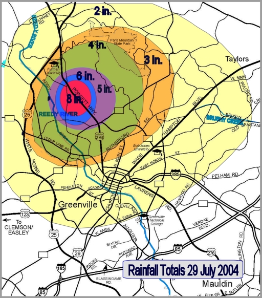 
Figure 2. Estimated total rain accumulation (top) and observed rainfall (bottom) across Greenville, South Carolina, on 29 July 2004.
4. Summary
No deaths or serious injuries resulted from the flood. At least 75 people were rescued from flooded vehicles, homes, and businesses. Damage to roads and bridges was estimated at $5.8 million. Approximately 30 homes were destroyed and another 100 homes and several businesses sustained significant flood damage.
|


 Hourly Weather