A strong storm will move across the Intermountain West into the Northern Great Plains bringing widespread high winds with increasing snow. An intense and fast-moving line of severe storms is expected across the Mississippi Valley into the Ohio Valley beginning Friday afternoon. A wildfire outbreak is possible across parts of the southern and central Plains due to strong winds and dry conditions. Read More >
Greenville-Spartanburg, SC
Weather Forecast Office
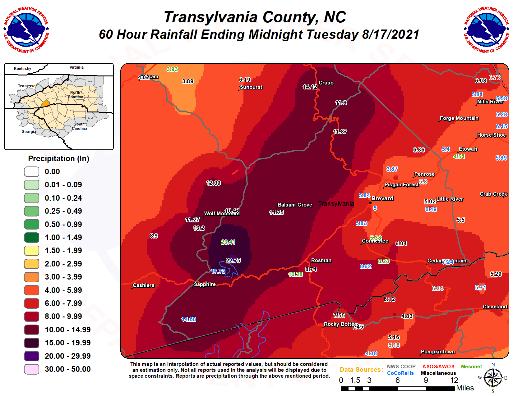
Tropical Storm Fred made landfall in the central Florida Panhandle during the afternoon of 16 August 2021 and moved north/northeast through western and northern Georgia before crossing the southern Appalachians on the 17th. Tropical moisture combined with prolonged southeast upslope flow into the Blue Ridge escarpment resulted in enhanced rainfall rates across the southeast-slopes of the Carolina and northeast Georgia mountains throughout the 17th, with storm total rainfall of 5-10" reported across mph of this area. This heavy rain fell on the heels of a smaller scale heavy rainfall event that occurred across the southern mountains of North Carolina, where up to 10 inches of rain fell over a localized area near the Transylvania and Jackson County border on the morning of the 16th. This resulted in significant flash flooding near the headwaters of the French Broad River in Transylvania County, where an automated gauge at Rosman reported its highest level in almost 30 years and fourth highest level in the gauge's history (continuous observations at that site date back to 1935).
As bands of heavy rain surrounding the remnant circulation of Fred developed over the region on the 17th, additional heavy rainfall within the upper French Broad basin caused a new round of flash flooding during the late afternoon and evening. This time, the Rosman gauge exceeded its 16 August reading, reaching major flood stage and the second highest level on record (4 October 1964). Two-day rainfall totals of up to two feet occurred in western Transylvania County near Lake Toxaway. Unfortunately, rainfall data from the National Weather Service co-op station at Lake Toxaway is not available for these two days, but the highest three day rainfall total reported at that site is 18.65" (September 2009) since records began in 1950. It was also around this time that very heavy rainfall in the high elevations of the Balsam Range resulted in major flash flooding in the headwaters of the Pigeon River in southern Haywood County. A stream gauge on the East Fork of the Pigeon River in the Cruso community exceeded its record by more than 3 feet (previous record was in association with Tropical Cyclone Ivan, September 2004). At one point, the river rose more than 2.5 feet in only 30 minutes. Catastrophic flash flooding, possibly in conjunction with major landslides developed along the East Fork in Cruso, sweeping multiple recreational vehicles downstream and damaging or destroying multiple homes. Six confirmed fatalities were reported in this area. This water worked its way downstream to the stream gauge At Canton, where major flooding developed on the Pigeon River for the first time in almost 20 years (Tropical Cyclone Ivan) and reached its fourth highest level on record (continuous observations at this site date to 1928.)
In addition to the heavy rain and flooding, enhanced low level wind shear resulting from the circulation passing along the western periphery of the forecast area combined with instability to produce embedded rotating cells within tropical rain bands. Several short-lived, weak tornadoes occurred, mainly across upstate South Carolina.

Forecast
Hourly Forecast Graph
Weather Activity Planner
Text Forecasts and Hazards
Graphical Forecasts
Aviation
Fire Weather
Lake Forecasts
Mountain Forecasts
Weather Prediction Center
Model Data
Hazards
Hazardous Weather Outlook
Severe Thunderstorms
Heavy Rainfall and Flooding
Tropical Weather
Reporting Severe Wx
Storm Prediction Center
National Hurricane Center
Space Weather
Office Programs
Local Research
Newsletter
NOAA Weather Radio
Skywarn
Cooperative Observers
CoCoRaHS
StormReady
WRN Ambassadors
Office Staff
US Dept of Commerce
National Oceanic and Atmospheric Administration
National Weather Service
Greenville-Spartanburg, SC
GSP International Airport
1549 GSP Drive
Greer, SC 29651
(864) 848-3859
Comments? Questions? Please Contact Us.


