Thunderstorms, some severe, may produce heavy to excessive rainfall and isolated flooding over portions of the Southern Plains today and Saturday. Dry conditions, combined with gusty winds and low relative humidities will continue to support an elevated to critical fire weather threat in the Desert Southwest into to early next week. Read More >

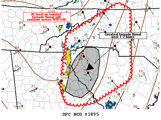
   MESOSCALE DISCUSSION 1895
   NWS STORM PREDICTION CENTER NORMAN OK
   0529 PM CDT TUE OCT 14 2014

   AREAS AFFECTED...PORTIONS OF E-CENTRAL GA ...WRN AND CENTRAL SC AND
   WRN NC

   CONCERNING...TORNADO WATCH 548...

   VALID 142229Z - 150000Z

   THE SEVERE WEATHER THREAT FOR TORNADO WATCH 548 CONTINUES.

   SUMMARY...TORNADO THREAT MAY BE HIGHEST ACROSS PARTS OF FAR
   E-CENTRAL GA INTO WRN/CENTRAL SC THE NEXT 1-2 HOURS. THE THREAT
   SHOULD THEN SLOWLY DIMINISH INTO THE EVENING TOWARD WRN NC.

   DISCUSSION...AT LEAST AN ISOLATED TORNADO THREAT WILL CONTINUE A FEW
   MORE HOURS ACROSS THE REMAINDER OF THE WATCH AREA. LOW LEVEL WIND
   PROFILES CONTINUE TO BE FAVORABLE FOR BRIEF TORNADOES WITH 0-1 KM
   SRH NEAR 350 M2/S2 PER REGIONAL VAD WIND PROFILES. ADDITIONALLY...A
   CORRIDOR EXISTS NEAR FAR E-CENTRAL GA INTO WRN SC WHERE SOME AIRMASS
   RECOVERY HAS LIKELY OCCURRED AND SFC DEWPOINTS ARE IN THE LOW 70S.
   THE TORNADO THREAT MAY BE MAXIMIZED IN THIS AREA WHERE BETTER SFC
   CONVERGENCE ALONG THE FRONT IS JUXTAPOSED WITH FAVORABLE LOW LEVEL
   SHEAR AND THERMODYNAMICS. OVER THE LAST 30 MINUTES OR SO RADAR
   REFLECTIVITY HAS INCREASED IN THE EWD ADVANCING LINE SEGMENTS AND
   EVEN SOME WEAK MID TO LOW LEVEL ROTATION WAS NOTED IN RECENT BASE
   VELOCITY DATA FROM THE KGSP RADAR. IN ADDITION TO BRIEF
   TORNADOES...A FEW STRONG/DAMAGING WIND GUSTS ALSO WILL BE POSSIBLE.
   AS THE LINE CONTINUES TO LIFT THE ENE INTO WRN NC...THE SEVERE
   THREAT WILL LIKELY DIMINISH GIVEN A COOLER AIRMASS AND LOWER
   DEWPOINT ENVIRONMENT WHERE WIDESPREAD RAINFALL HAS BEEN OCCURRING.

   ..LEITMAN.. 10/14/2014


   ATTN...WFO...RAH...RNK...CAE...GSP...MRX...FFC...

   LAT...LON   35638309 36778078 36578023 34028031 33178199 33098270
               33178311 33758334 35638309
|