Thunderstorms, some severe, may produce heavy to excessive rainfall and isolated flooding over portions of the Southern Plains today and Saturday. Dry conditions, combined with gusty winds and low relative humidities will continue to support an elevated to critical fire weather threat in the Desert Southwest into to early next week. Read More >

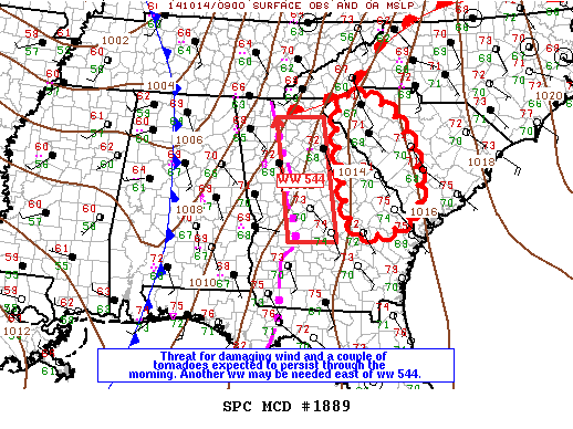
MESOSCALE DISCUSSION 1889 NWS STORM PREDICTION CENTER NORMAN OK 0522 AM CDT TUE OCT 14 2014 AREAS AFFECTED...ERN GA THROUGH WRN SC CONCERNING...SEVERE POTENTIAL...WATCH LIKELY VALID 141022Z - 141145Z PROBABILITY OF WATCH ISSUANCE...80 PERCENT SUMMARY...LINE OF STORMS CAPABLE OF SPORADIC INSTANCES OF DAMAGING WIND AND A COUPLE OF TORNADOES IS EXPECTED TO CONTINUE THROUGH THE REMAINDER OF ERN GA AND EVENTUALLY INTO SC THIS MORNING. STORMS WILL APPROACH THE ERN BORDER OF WW 543 BY 11Z...AND EXISTING WW CAN BE EXTENDED FARTHER EAST. HOWEVER...ANOTHER WW WILL LIKELY BE NEEDED DOWNSTREAM TO INCLUDE EXTREME ERN GA INTO SC. DISCUSSION...LINE OF STORMS FROM NCNTRL GA SWWD THROUGH SWRN GA CONTINUES EAST AT 25-35 KT WHILE INDIVIDUAL ELEMENTS WITHIN THE LINE MOVE RAPIDLY NEWD. A VERY MOIST BOUNDARY LAYER WITH 70F DEWPOINTS HAS ADVECTED THROUGH THE WARM SECTOR DOWNSTREAM FROM THIS ACTIVITY RESULTING IN 500-800 J/KG MUCAPE WELL INTO SC. LLJ HAS BEEN STRENGTHENING INTO THE EARLY MORNING AS IT DEVELOPS EWD AND NEWD THROUGH THE TN AND OH VALLEY IN RESPONSE TO A SHORTWAVE TROUGH LIFTING NEWD THROUGH MS AND WRN TN. VWP DATA FROM WARNER ROBINS SAMPLED THE SRN EXTENSION OF THE LLJ WITH 50 KT INDICATED JUST BELOW 1 KM. STORMS WITHIN THE LINE INTERACTING WITH STRONG LOWER-MID TROPOSPHERIC WINDS AND THE MOIST BOUNDARY LAYER SHOULD CONTINUE TO EXHIBIT OCCASIONAL ORGANIZATION INCLUDING LEWP AND EMBEDDED SUPERCELLS AS ACTIVITY DEVELOPS EWD THIS MORNING. ..DIAL/EDWARDS.. 10/14/2014 |