Thunderstorms later in the day Sunday could produce locally strong or damaging wind gusts, isolated large hail, and a brief tornado or two within the southern half of Lower Michigan. Read More >
Overview
Additional Snow Accumulations Late Tonight
.png)
.png)
The map above reflects reported observations. Due to the lack of reports received in some locations the map may not be entirely representative of local values. This is especially true of areas that see high variability in short distances, such as locations affected by narrow, heavy snow bands -or- lake effect snow.
Snowfall Reports
PUBLIC INFORMATION STATEMENT
NATIONAL WEATHER SERVICE GRAND RAPIDS MI
952 AM EDT SAT APR 9 2016

...SNOWFALL REPORTS PAST 24 HOURS...

LOCATION                     AMOUNT    TIME/DATE       LAT/LON

...ALLEGAN COUNTY...
4 SE GLENN                   1.3 IN    0740 AM 04/09   42.48N/86.17W
HOPKINS 1 N                  1.1 IN    0700 AM 04/09   42.64N/85.76W
WAYLAND 2.0 W                1.0 IN    0700 AM 04/09   42.67N/85.68W

...BARRY COUNTY...
HASTINGS                     4.0 IN    0700 AM 04/09   42.65N/85.30W
DELTON                       4.0 IN    0723 AM 04/09   42.50N/85.41W
HASTINGS 4.3 SSW             3.0 IN    0700 AM 04/09   42.59N/85.32W

...CLARE COUNTY...
HARRISON 5.2 ESE             0.2 IN    0800 AM 04/09   43.99N/84.70W

...CLINTON COUNTY...
CAPITAL CITY AIRPORT         4.8 IN    0753 AM 04/09   42.78N/84.59W

...EATON COUNTY...
BELLEVUE                     4.8 IN    0700 AM 04/09   42.44N/85.02W
LANSING 3.9 WNW              4.7 IN    0640 AM 04/09   42.72N/84.63W
1 W WAVERLY                  4.4 IN    1030 AM 04/09   42.74N/84.65W
SUNFIELD                     3.0 IN    0800 AM 04/09   42.76N/84.99W

...INGHAM COUNTY...
OKEMOS                       5.2 IN    0845 AM 04/09   42.71N/84.41W
4 NNW DANSVILLE              5.0 IN    0800 AM 04/09   42.61N/84.34W
1 WSW LANSING                4.5 IN    0700 AM 04/09   42.70N/84.59W
2 SE LESLIE                  4.2 IN    0700 AM 04/09   42.42N/84.40W

...IONIA COUNTY...
SARANAC 2.6 NE               3.7 IN    0630 AM 04/09   42.96N/85.17W

...JACKSON COUNTY...
3 WSW PARMA                  7.5 IN    1028 AM 04/09   42.23N/84.65W
4 NNE SANDSTONE              7.0 IN    0650 AM 04/09   42.31N/84.48W

...KALAMAZOO COUNTY...
KALAMAZOO                    2.8 IN    0445 AM 04/09   42.27N/85.59W
KALAMAZOO 6.0 SW             2.7 IN    0810 AM 04/09   42.21N/85.66W

...KENT COUNTY...
NWS FORECAST OFFICE GRAND RA 5.6 IN    0800 AM 04/09   42.89N/85.54W
EAST GRAND RAPIDS 0.7 SSW    4.7 IN    0700 AM 04/09   42.94N/85.61W
ADA 1.8 W                    3.2 IN    0530 AM 04/09   42.95N/85.53W
2 W ADA                      3.2 IN    0535 AM 04/09   42.95N/85.53W
GRAND RAPIDS 3.1 NNE         1.2 IN    0500 AM 04/09   43.01N/85.64W

...MASON COUNTY...
SCOTTVILLE 2 SE              0.1 IN    0700 AM 04/09   43.93N/86.25W

...MECOSTA COUNTY...
3 NNW STANWOOD               0.1 IN    0700 AM 04/09   43.63N/85.48W
2 NW SYLVESTER               0.1 IN    0800 AM 04/09   43.56N/85.28W

...NEWAYGO COUNTY...
WHITE CLOUD 7.5 ENE          0.6 IN    0700 AM 04/09   43.61N/85.64W

...OTTAWA COUNTY...
1 WSW JENISON                1.3 IN    0748 AM 04/09   42.90N/85.84W
2 E MACATAWA                 0.2 IN    0800 AM 04/09   42.77N/86.16W

...VAN BUREN COUNTY...
BLOOMINGDALE                 1.5 IN    0800 AM 04/09   42.38N/85.97W
PAW PAW 3.6 NNE              1.0 IN    0715 AM 04/09   42.27N/85.86W

OBSERVATIONS ARE COLLECTED FROM A VARIETY OF SOURCES WITH VARYING
EQUIPMENT AND EXPOSURE. NOT ALL DATA LISTED ARE CONSIDERED OFFICIAL.
SPORADIC REPORTS MAY BE MANUALLY ADDED TO THIS LIST IF RECEIVED AFTER
THE TIMESTAMP AT THE TOP OF THE REPORT REPORT.

$$

NWS GRAND RAPIDS MI
IRIS SYSTEM
Snowfall Records
RECORD EVENT REPORT
NATIONAL WEATHER SERVICE GRAND RAPIDS, MI
0127 AM EDT SAT APR 09 2016

...RECORD DAILY MAXIMUM SNOWFALL SET AT GRAND RAPIDS MI...

A RECORD SNOWFALL OF 5.4 INCHES WAS SET AT GRAND RAPIDS MI
YESTERDAY. THIS BREAKS THE OLD RECORD OF 4.3 SET IN 1938.
RECORD EVENT REPORT
NATIONAL WEATHER SERVICE GRAND RAPIDS, MI
813 AM EDT SAT APR 09 2016

...RECORD DAILY SNOW DEPTH SET AT GRAND RAPIDS MI...

A RECORD SNOW DEPTH OF 5 INCHES WAS SET AT GRAND RAPIDS MI
TODAY. THIS BREAKS THE OLD RECORD OF 4 INCHES SET IN 1982.
RECORD EVENT REPORT
NATIONAL WEATHER SERVICE GRAND RAPIDS, MI
815 AM EST SAT APR 9 2016

...RECORD DAILY SNOW DEPTH TIED AT LANSING MI...

A RECORD SNOW DEPTH OF 4 INCHES WAS TIED AT LANSING MI
TODAY. THIS TIES THE OLD RECORD OF 4 INCHES IN 1982
Flooding:
Click here for the most recent flood warning product.
Click here for the most recent flood advisory product.
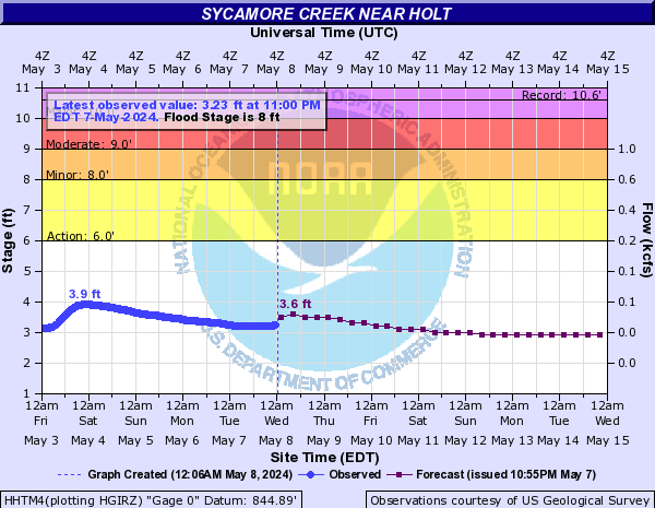
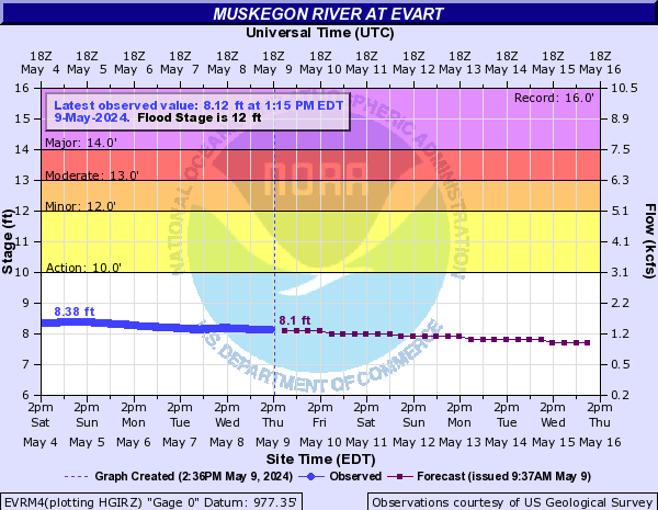
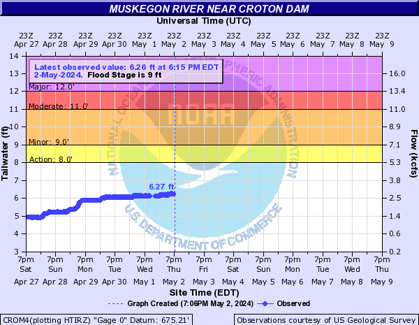
River Levels
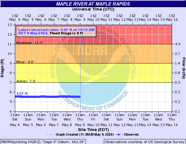
The blue curve on the left half of the chart is the measured river level over the past several days. The purple curve on the right half of the chart is the forecast river level over the next week. Click on a chart for additional information. Click here for current information about all river levels around the area.
 |
 |
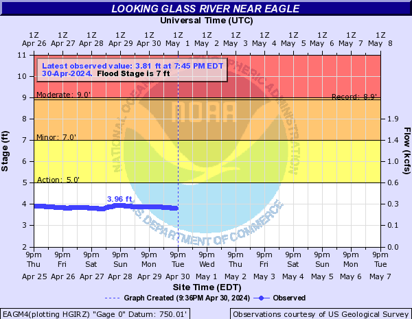 |
| Muskegon River at Evart | Muskegon River at Croton | Looking Glass River at Eagle |
 |
 |
|
| Grand River at Ionia | Maple River at Maple Rapids | Sycamore Creek at Holt |
Spotter Training Schedule:
Spotter Classes start promptly at the time listed below. Classes are free and open to the public. Classes that require registration due to limited space are listed below. If ‘Registration Required’ is not listed below, there is no registration for the class offering.
Any questions, please email us at: w-grr.webmaster@noaa.gov
|
Date |
Time |
Location |
Sponsor |
|
Saturday, April 16, 2016 |
2:00pm - 4:00pm |
2424 Washington Road Lansing, MI 48911 |
Ingham County |
|
Saturday, April 23, 2016 |
10:00am - 12:00pm |
Clare County Transportation Cabinet 1473 Transportation Drive Harrison, MI 48625 |
Clare County |
|
Saturday, April 23, 2016 |
2:00pm - 4:00pm |
Central Michigan University Brooks Hall - Room 176 |
Isabella County and Central Michigan University |
|
Saturday, April 30, 2016 |
10:00am - 12:00pm |
Alma College Swanson Academic Center 614 Superior Street Alma, MI |
Gratiot County |
 |
Media use of NWS Web News Stories is encouraged! |
|