A heat wave over the Southwest will intensify late week, peaking and expanding into the Intermountain West and northern High Plains this weekend. Severe thunderstorms and heavy rain are expected over portions of the Plains and Mississippi Valley tonight, which will shift to parts of the Upper Midwest and mid-Mississippi Valley Friday. Monsoonal showers and flooding persist in the Desert Southwest. Read More >
Event Overview
A line of severe thunderstorms impacted lower Michigan during the evening hours of August 28th, 2018. Strong winds of 50 to 60 mph were common along the line with pockets of intense damaging winds of 75 to 90 mph. There were also two tornadoes embedded within the strongest winds near Baldwin and Idlewild. The most extensive damage was along US-10 from Ludington to Reed City, with separate areas of intense damage near Big Rapids and Le Roy. In all, the line of storms was responsible for 25 tornadoes across Wisconsin and Michigan (19 in Wisconsin, 6 in Michigan).
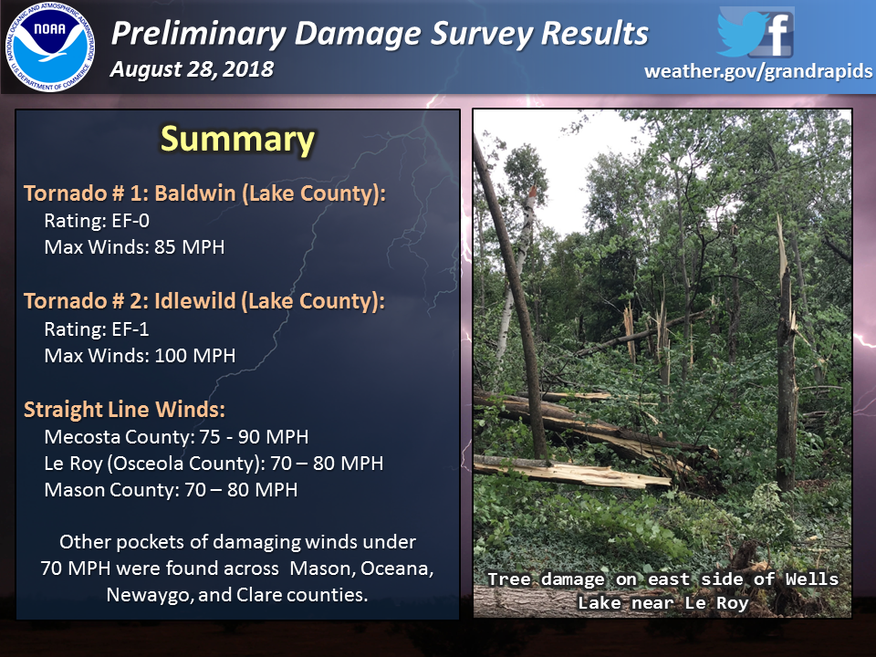 |
| Summary of the damage surveys conducted after the event. |
Note that it can be difficult to ascertain whether tornadoes occur in a broader region of straight line winds. Tornadoes that develop in lines of thunderstorms are often weak and transient, leading to short (and at times discontinuous) damage paths. Yet, the region of damaging winds in which tornadoes may be embedded often has wind speeds similar (if not stronger) in magnitude compared to the weak tornadoes. While we try our best to determine if tornadoes indeed occurred using both radar data and in-person damage surveys, sometimes determinations can not be made. Keep in mind that winds do not have to rotate to be dangerous as the majority of damage surveyed from this event was not produced by tornadoes.
This storm system impacted a large portion of the Great Lakes. Check out other storm summaries, including information on additional tornadoes, below:
Northern Michigan (NWS Gaylord)
Central Wisconsin 1 (NWS Milwaukee)
Central Wisconsin 2 (NWS Green Bay)
Note: The information in this storm summary is considered preliminary and may change in the coming weeks as additional information is examined. Moreover, this summary does not represent the full scale of damage across the area. Swaths of damage from severe winds also occurred in Oceana, Newaygo, and Clare Counties.
Tornadoes:
|
Tornado: Baldwin
Track Map  |
||||||||||||||||
 |
 |
 |
 |
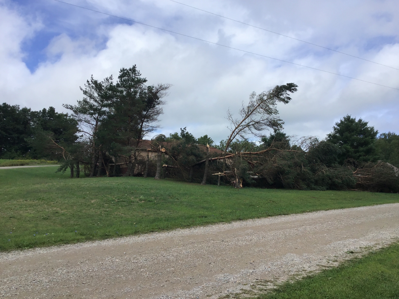
| Damage to trees along Michigan Ave near Cedar street in Baldwin | Uprooted trees near Eight and Norway streets in Baldwin | Damage to a building along Eighth street near Michigan Ave near downtown Baldwin. | Downed trees near the intersection of Oak and 9th streets in Baldwin |
|
Tornado: Idlewild
Track Map 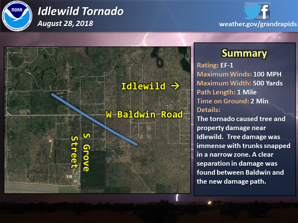
|
||||||||||||||||
.jpg) |
 |
||
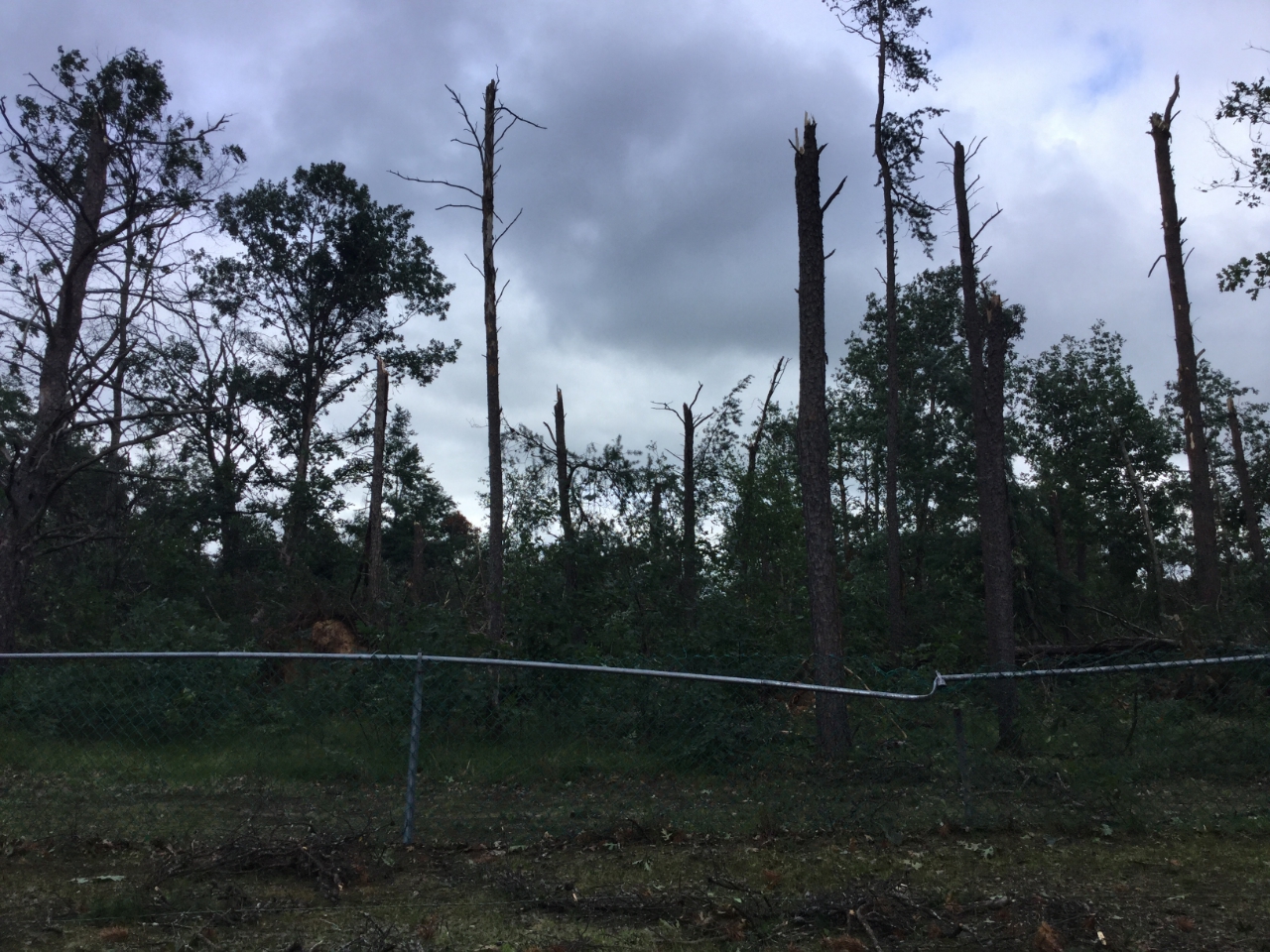
| Extensive tree damage along Indianapolis Ave west of Idlewild | Snapped trees along Jenkins Street west of Idlewild | . |
 |
| The Baldwin and Idlewild tornadoes were produced by the same storm but there was a clear separation in damage between the two paths. |
The Enhanced Fujita (EF) Scale classifies tornadoes into the following categories:
| EF0 Weak 65-85 mph |
EF1 Moderate 86-110 mph |
EF2 Significant 111-135 mph |
EF3 Severe 136-165 mph |
EF4 Extreme 166-200 mph |
EF5 Catastrophic 200+ mph |
 |
|||||
Damaging Winds:
|
Le Roy / Wells Lake
Track Map
|
||||||||||||||||||
|
Mecosta County
Track Map
|
||||||||||||||||||
|
Mason County
Track Map  |
||||||||||
Radar:
A line of severe thunderstorms quickly advanced from Wisconsin into lower Michigan prompting an array of Severe Thunderstorm Warnings. A separate cluster of storms developed over Allegan and Kent counties with generally 40-50 mph (isolated 60 mph) wind gusts locally downing trees.
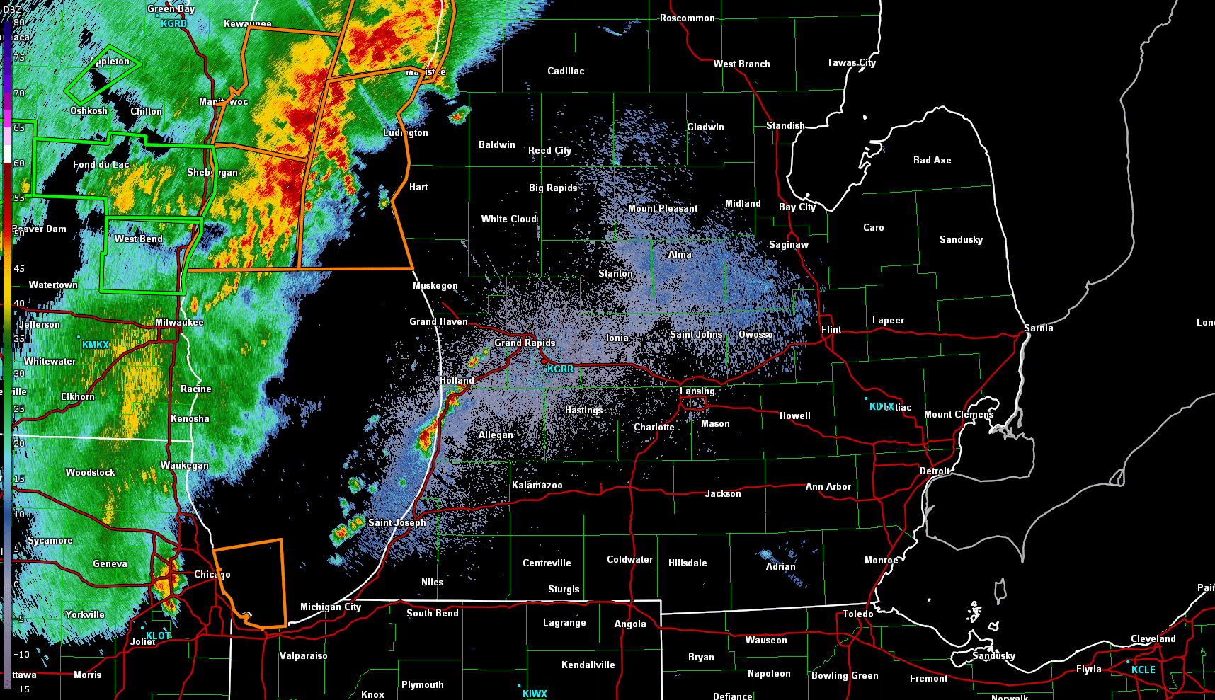 |
| Base reflectivity from KGRR (Grand Rapids) between approximately 6:30 to 9:00 PM ET. The orange (green) polygons are Severe Thunderstorm or Special Marine (Flash Flood) warnings. |
3-Day Rainfall Total:
Multiple rounds of thunderstorms impacted lower Michigan from 8/26 to 8/29, leading to fairly widespread rainfall totals greater than 2" north of I-96. The hardest hit areas in Muskegon county saw nearly 8-10" by the time the rain stopped.
 |
 |
Media use of NWS Web News Stories is encouraged! Please acknowledge the NWS as the source of any news information accessed from this site. |
|
/* Styling for images that are designed to be enlarged via jquery script */ img.magnify { background-color:#ffffff; border-width: 1px; border-style: solid; border-color: #000000; padding: 4px; -webkit-box-shadow: 0 0 6px rgba(132, 132, 132, .75); -moz-box-shadow: 0 0 6px rgba(132, 132, 132, .75); box-shadow: 0 0 6px rgba(132, 132, 132, .75); -webkit-border-radius: 4px; -moz-border-radius: 4px; border-radius: 4px; cursor: pointer; } img.magnify:hover { -webkit-box-shadow: 0 0 0px rgba(132, 132, 132, .75); -moz-box-shadow: 0 0 0px rgba(132, 132, 132, .75); box-shadow: 0 0 0px rgba(132, 132, 132, .75); }