
Strong to severe thunderstorms will continue this evening from eastern Texas into the lower Mississippi and Tennessee Valleys/southern Appalachians. The strongest storms could produce a few strong tornadoes (EF2+), damaging wind gusts, large hail, and locally heavy to excessive rainfall which may results in flash and urban flooding. Read More >
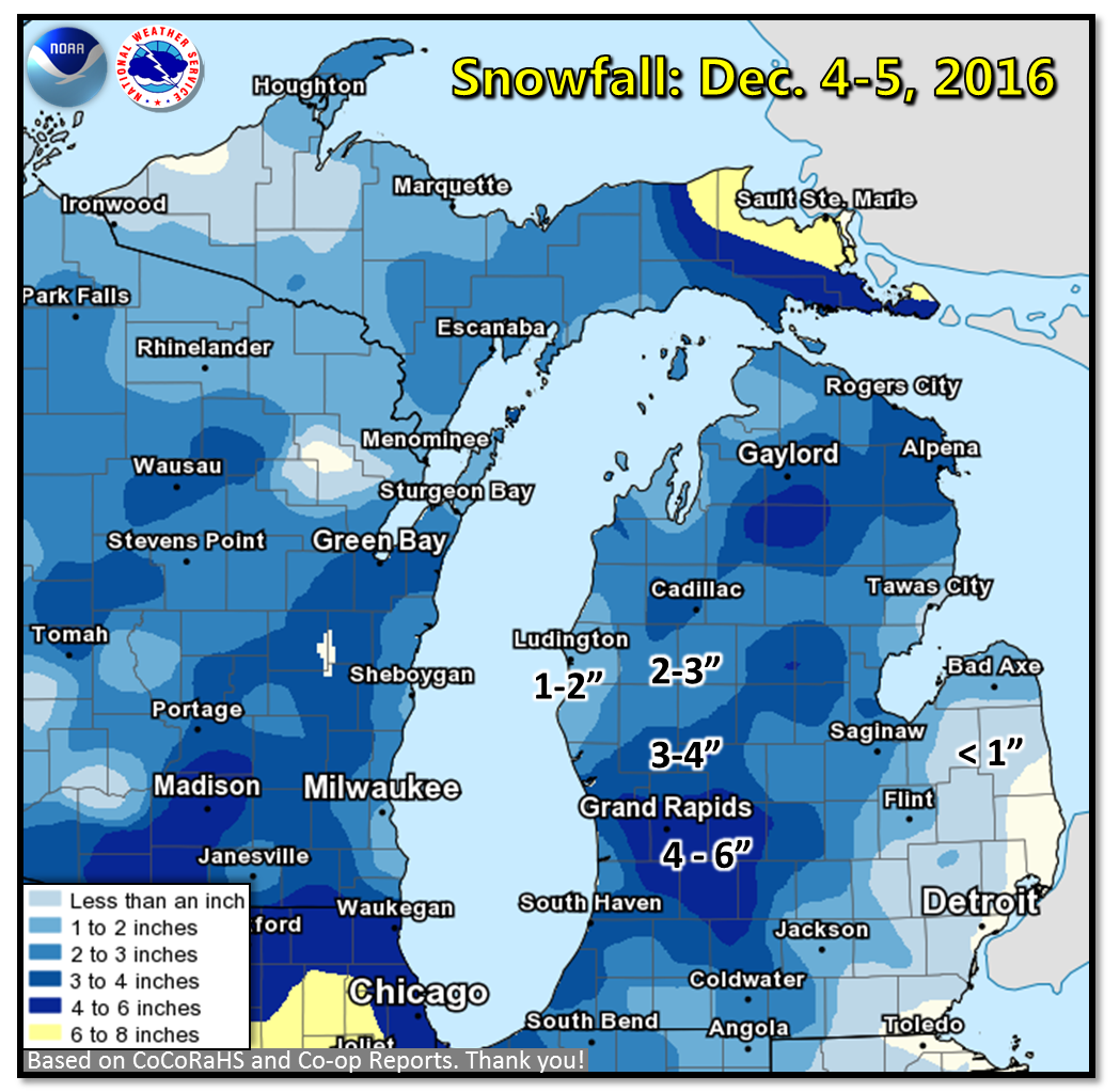
Snow began to overspread Lower Michigan late Sunday morning and early Sunday afternoon of December 4th. Temperatures hovered in the low to mid-30s, causing most of the onset of snowfall to melt upon contact. However, snow quickly became moderate to heavy through the evening hours over Grand Rapids, which resulted in slushy roadways. Several areas became slick through late evening, when temperatures dropped near and below freezing. The heavy, wet nature of the snow also led to power outages for some residents, but was quickly restored for most locations by early Monday morning.
The greatest snowfall totals were found in Barry and Kent Counties, where amounts of 5-6 inches were reported. A band of 3-4 inch snowfall totals stretched from Muskegon, northeast through the Harrison area. Amounts tapered off to the south and east with less than 1 inch near Detroit.
Public Information Statement
National Weather Service Grand Rapids MI
341 PM EST Mon Dec 5 2016

...Snowfall Reports. Ending Times from Last Night and This
Morning...

Location                     Amount    Time/Date       Lat/Lon

...Michigan...

...Allegan County...
1 S Ganges                   5.0 in    0810 PM 12/04   42.57N/86.21W
1 N Hopkins                  4.5 in    0800 AM 12/05   42.65N/85.76W
Saugatuck                    4.5 in    0725 PM 12/04   42.66N/86.21W
1 W Wayland                  4.2 in    0700 AM 12/05   42.67N/85.68W
3 W Martin                   3.5 in    0705 PM 12/04   42.54N/85.70W
Allegan                      3.0 in    0700 PM 12/04   42.53N/85.85W
Fennville                    3.0 in    0655 PM 12/04   42.60N/86.11W

...Barry County...
Hastings                     6.0 in    0515 AM 12/05   42.65N/85.29W
Hastings                     6.0 in    0700 AM 12/05   42.65N/85.30W
4 SSW Hastings               5.0 in    0600 AM 12/05   42.59N/85.32W
Delton                       4.7 in    0800 PM 12/04   42.50N/85.40W
2 ESE Assyria                4.5 in    0700 AM 12/05   42.45N/85.10W
Plainwell 5.4 E              2.8 in    0800 AM 12/05   42.45N/85.54W

...Calhoun County...
Springfield                  4.0 in    0700 PM 12/04   42.33N/85.24W
Bedford                      2.3 in    0646 PM 12/04   42.40N/85.23W

...Clare County...
Leota                        4.0 in    0602 AM 12/05   44.14N/84.89W
8 SW Skeels                  3.6 in    0800 AM 12/05   43.99N/84.70W
Lake George                  1.5 in    0730 PM 12/04   43.96N/84.95W

...Clinton County...
1 NW Dewitt                  4.0 in    0700 AM 12/05   42.85N/84.58W
Laingsburg 5.0 SW            4.0 in    0700 AM 12/05   42.84N/84.42W
Capital City Airport         3.0 in    0653 AM 12/05   42.78N/84.59W

...Eaton County...
Grand Ledge                  4.0 in    0800 AM 12/05   42.76N/84.75W
1 SSW Waverly                3.0 in    0700 AM 12/05   42.72N/84.63W
1 SSW Waverly                2.5 in    0700 AM 12/05   42.72N/84.63W
Eaton Rapids                 2.0 in    0800 AM 12/05   42.52N/84.65W
Charlotte                    1.5 in    0630 PM 12/04   42.57N/84.83W
1 SSW Waverly                0.8 in    0700 PM 12/04   42.72N/84.63W

...Gratiot County...
Saint Louis                  2.7 in    1159 PM 12/04   43.40N/84.61W
Alma                         2.0 in    0700 AM 12/05   43.38N/84.67W
4 NNE Saint Louis            0.5 in    0725 PM 12/04   43.46N/84.58W

...Ingham County...
4 NNW Dansville              2.3 in    0800 AM 12/05   42.61N/84.34W

...Ionia County...
2 NE Saranac                 5.4 in    0625 AM 12/05   42.96N/85.17W
Portland                     3.0 in    0847 PM 12/04   42.87N/84.90W

...Isabella County...
4 SSE Shepherd               2.3 in    0600 AM 12/05   43.47N/84.67W
Mount Pleasant               1.0 in    0625 AM 12/05   43.60N/84.78W

...Jackson County...
1 ESE Pulaski                3.0 in    0735 AM 12/05   42.11N/84.63W
2 NNE Topkins                0.9 in    0815 AM 12/05   42.41N/84.53W

...Kalamazoo County...
3 W Portage                  3.5 in    0810 AM 12/05   42.21N/85.66W
1 SSW Eastwood               3.0 in    0730 PM 12/04   42.29N/85.56W
1 S Portage                  2.5 in    0700 PM 12/04   42.18N/85.59W
3 W Portage                  2.5 in    0636 PM 12/04   42.21N/85.65W
2 SE Kalamazoo               2.0 in    0730 PM 12/04   42.26N/85.56W
1 SW Westwood                2.0 in    0630 PM 12/04   42.30N/85.64W
1 SW Eastwood                2.0 in    0535 PM 12/04   42.29N/85.56W
Kalamazoo                    1.0 in    0444 PM 12/04   42.27N/85.59W

...Kent County...
East Grand Rapids            5.9 in    0700 AM 12/05   42.94N/85.61W
Nws Forecast Office Grand Ra 5.6 in    0700 AM 12/05   42.89N/85.54W
Gerald R Ford Intl           5.6 in    0653 AM 12/05   42.89N/85.54W
1 WSW Grandville             5.1 in    0700 AM 12/05   42.90N/85.78W
Grandville                   5.1 in    0700 AM 12/05   42.90N/85.77W
3 WSW Cannonsburg            4.6 in    0810 PM 12/04   43.04N/85.52W
1 ESE Lowell                 4.5 in    0700 AM 12/05   42.92N/85.32W
1 SSW Dutton                 4.5 in    0640 AM 12/05   42.83N/85.59W
Grattan                      4.5 in    0745 PM 12/04   43.08N/85.38W
3 N Cannonsburg              4.3 in    0800 PM 12/04   43.10N/85.47W
2 N Cannonsburg              4.1 in    0715 AM 12/05   43.09N/85.47W
Rockford                     4.0 in    0700 AM 12/05   43.12N/85.56W
2 WNW Belmont                4.0 in    0545 AM 12/05   43.09N/85.64W
1 SSW East Grand Rapids      3.4 in    0700 PM 12/04   42.94N/85.61W
1 ESE East Grand Rapids      3.1 in    0730 AM 12/05   42.93N/85.58W
2 ENE Kentwood               3.1 in    0700 PM 12/04   42.89N/85.55W
Dutton                       3.0 in    0700 PM 12/04   42.84N/85.59W
Belmont                      3.0 in    0700 AM 12/05   43.08N/85.63W
1 WSW Grandville             2.8 in    0700 PM 12/04   42.90N/85.78W
3 E Rockford                 2.5 in    0700 PM 12/04   43.13N/85.50W
2 W Ada                      2.0 in    0548 PM 12/04   42.95N/85.53W
1 WNW Grandville             1.2 in    0400 PM 12/04   42.91N/85.77W

...Mecosta County...
Morley                       4.0 in    0458 AM 12/05   43.49N/85.45W
2 NW Sylvester               4.0 in    0800 AM 12/05   43.56N/85.28W
3 NNW Stanwood               3.8 in    0700 AM 12/05   43.63N/85.48W
2 NNW Sylvester              1.8 in    0645 PM 12/04   43.56N/85.27W
Big Rapids Water Works       1.6 in    0700 AM 12/05   43.70N/85.48W

...Montcalm County...
Greenville                   3.0 in    0645 PM 12/04   43.18N/85.25W
3 ESE Mcbride                3.0 in    0700 AM 12/05   43.31N/84.99W

...Muskegon County...
Muskegon County Airport      3.6 in    0655 AM 12/05   43.17N/86.24W
2 W Cloverville              2.6 in    0700 PM 12/04   43.19N/86.20W
Muskegon 4 SE                1.0 in    0100 AM 12/05   43.18N/86.20W

...Newaygo County...
4 SE Woodville               3.2 in    0700 AM 12/05   43.61N/85.64W
4 WSW Fremont                3.0 in    0700 AM 12/05   43.45N/86.03W

...Oceana County...
4 SSE Stony Lake             1.6 in    0700 AM 12/05   43.50N/86.47W

...Osceola County...
Reed City Wwtp               2.3 in    0700 AM 12/05   43.87N/85.50W

...Ottawa County...
2 SE Marne                   5.0 in    0800 PM 12/04   43.02N/85.80W
1 SSW Allendale              4.8 in    0800 AM 12/05   42.97N/85.96W
Holland                      4.0 in    0755 PM 12/04   42.77N/86.10W
1 S Allendale                3.5 in    0715 PM 12/04   42.97N/85.95W
2 NW Beechwood               2.5 in    0730 AM 12/05   42.82N/86.15W
1 S Allendale                2.3 in    0442 PM 12/04   42.97N/85.95W
3 NE Beechwood               2.0 in    0437 PM 12/04   42.83N/86.09W
Holland                      2.0 in    0700 AM 12/05   42.80N/86.12W

...Van Buren County...
Bloomingdale                 4.0 in    0700 AM 12/05   42.38N/85.97W
Keeler                       3.0 in    0710 PM 12/04   42.12N/86.17W
1 NE Grand Junction          3.0 in    0615 PM 12/04   42.41N/86.06W
Mattawan                     2.5 in    0655 PM 12/04   42.22N/85.79W
Bangor                       2.0 in    0725 PM 12/04   42.31N/86.11W
Lawton                       2.0 in    0700 PM 12/04   42.17N/85.85W
3 NNE Paw Paw                2.0 in    0700 AM 12/05   42.27N/85.86W
Paw Paw                      1.6 in    0430 PM 12/04   42.22N/85.89W

Observations are collected from a variety of sources with varying
equipment and exposures. Not all data listed are considered official.

$$

NWS Grand Rapids MI
IRIS System
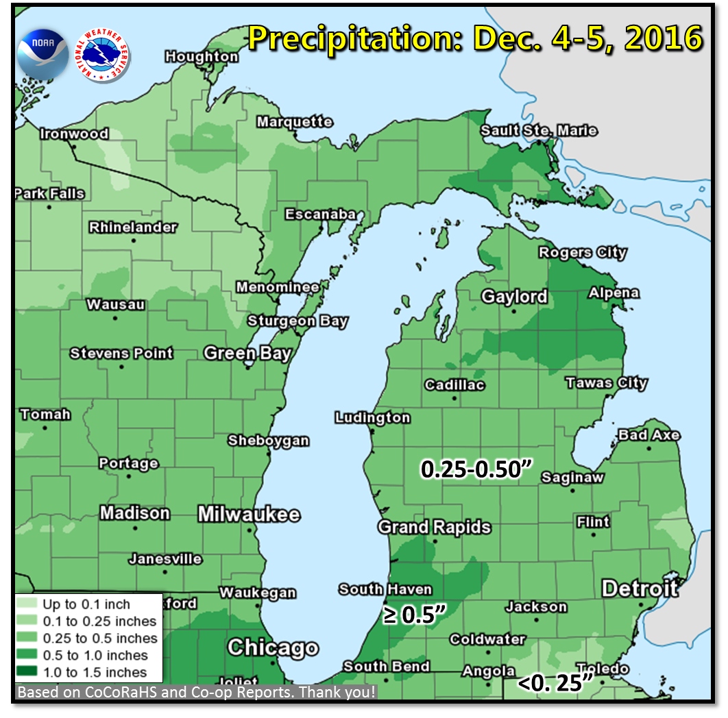
Precipitation is the liquid equivalent of all rain and snow, given the snow is melted. Amounts generally ranged from 0.25" across central Lower Michigan to around 0.5" over far southwest Lower Michigan.
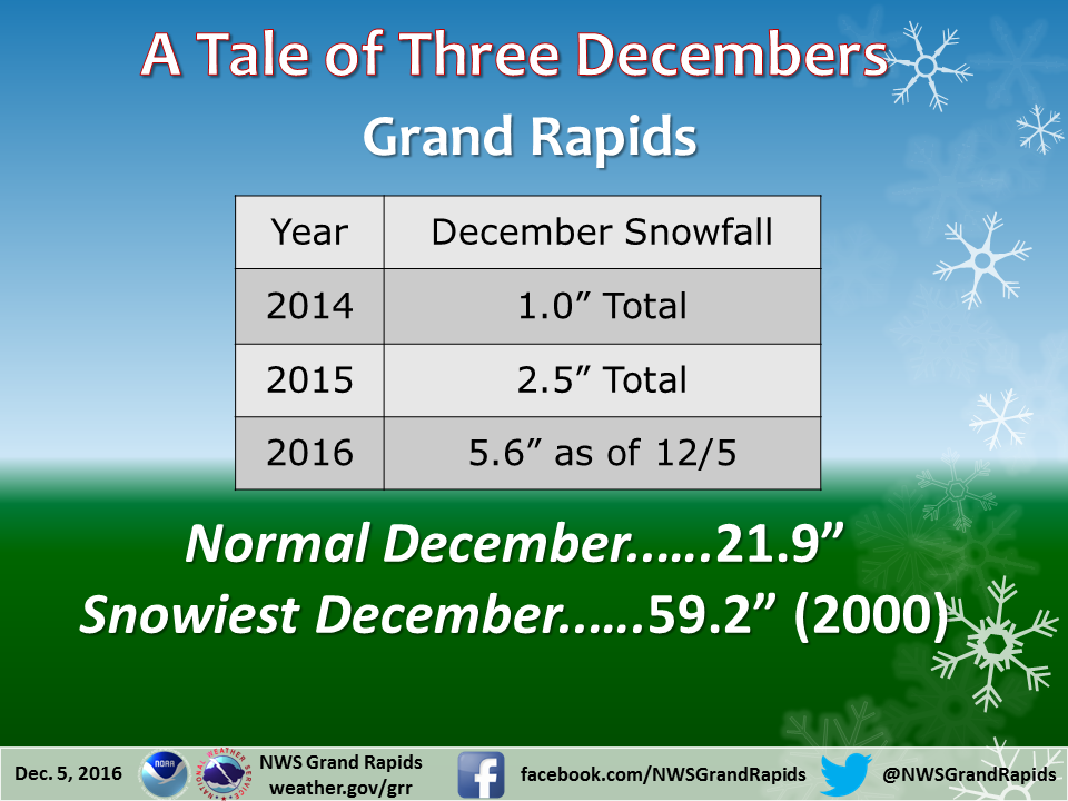
Snowfall amounts in December 2016 have already eclipsed the last two Decembers - combined!
 |
Media use of NWS Web News Stories is encouraged! |
|

