
Thunderstorms later in the day Sunday could produce locally strong or damaging wind gusts, isolated large hail, and a brief tornado or two within the southern half of Lower Michigan. Read More >
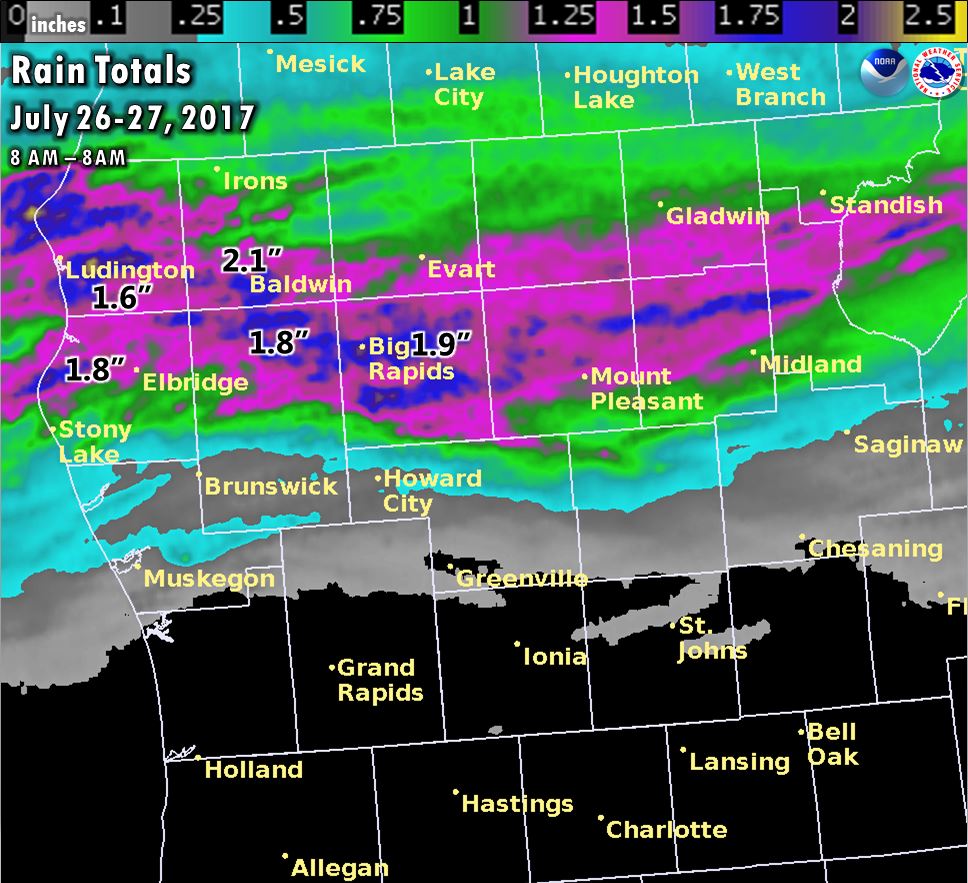
Public Information Statement
National Weather Service Grand Rapids MI
855 AM EDT Thu Jul 27 2017

...24 Hour Total Rainfall Reports...

Location                     Amount    Time/Date       Lat/Lon

...Michigan...

...Clare County...
8 SW Skeels                  0.54 in   0800 AM 07/27   43.99N/84.70W
2 SW Leota                   0.52 in   0812 AM 07/27   44.12N/84.92W

...Gratiot County...
Wheeler                      0.29 in   0838 AM 07/27   43.41N/84.46W
Breckenridge                 0.17 in   0700 AM 07/27   43.41N/84.47W

...Isabella County...
Mt Pleasant Muni Arpt        0.92 in   0754 AM 07/27   43.62N/84.74W
Mount Pleasant               0.82 in   0840 AM 07/27   43.59N/84.77W
4 SSE Shepherd               0.72 in   0835 AM 07/27   43.47N/84.67W
1 SSE Mount Pleasant         0.65 in   0835 AM 07/27   43.58N/84.77W
4 SSE Shepherd               0.24 in   0600 AM 07/27   43.47N/84.67W

...Kent County...
2 SE Cedar Springs           0.02 in   0831 AM 07/27   43.19N/85.51W
2 W Sparta                   0.02 in   0730 AM 07/27   43.16N/85.76W

...Lake County...
1 S Baldwin                  2.12 in   0738 AM 07/27   43.88N/85.85W

...Mason County...
6 NW Scottville              1.55 in   0500 AM 07/27   44.04N/86.34W
5 NNE Ludington              1.32 in   0837 AM 07/27   44.03N/86.41W
Ludington                    1.20 in   0839 AM 07/27   43.96N/86.43W
3 SSE Ludington              1.08 in   0836 AM 07/27   43.91N/86.42W
Mason Co Apt                 0.89 in   0755 AM 07/27   43.97N/86.42W

...Mecosta County...
Big Rapids Water Works       1.86 in   0700 AM 07/27   43.70N/85.48W
3 ESE Big Rapids             1.77 in   0700 AM 07/27   43.68N/85.44W
3 NNW Stanwood               1.73 in   0700 AM 07/27   43.63N/85.48W
2 NW Sylvester               1.62 in   0530 AM 07/27   43.56N/85.28W
Big Rapids Roben-hood Arpt   1.11 in   0755 AM 07/27   43.72N/85.50W

...Muskegon County...
3 SW Dalton                  0.29 in   0700 AM 07/27   43.28N/86.30W
Lakewood Club                0.23 in   0837 AM 07/27   43.37N/86.24W
1 ENE Norton Shores          0.14 in   0840 AM 07/27   43.17N/86.22W
Whitehall Lighthouse         0.12 in   0825 AM 07/27   43.37N/86.42W
Muskegon County Airport      0.09 in   0755 AM 07/27   43.17N/86.24W
1 WSW Norton Shores          0.08 in   0829 AM 07/27   43.16N/86.27W
Norton Shores                0.05 in   0840 AM 07/27   43.17N/86.26W

...Newaygo County...
4 SE Woodville               1.77 in   0700 AM 07/27   43.61N/85.64W
Croton                       0.18 in   0830 AM 07/27   43.43N/85.67W
1 S Newaygo                  0.16 in   0838 AM 07/27   43.40N/85.80W
4 WSW Fremont                0.13 in   0700 AM 07/27   43.45N/86.03W
3 ENE Bridgeton              0.12 in   0700 AM 07/27   43.38N/85.88W

...Oceana County...
Hart                         1.76 in   0700 AM 07/27   43.70N/86.37W
Pentwater                    1.13 in   0827 AM 07/27   43.78N/86.43W
3 ENE Pentwater              0.53 in   0832 AM 07/27   43.81N/86.38W
4 SSE Stony Lake             0.37 in   0700 AM 07/27   43.50N/86.47W

...Osceola County...
Reed City Wwtp               1.44 in   0700 AM 07/27   43.87N/85.50W
2 SE Hersey                  0.82 in   0839 AM 07/27   43.82N/85.41W

Observations are collected from a variety of sources with varying
equipment and exposures. We thank all volunteer weather observers
for their dedication. Not all data listed are considered official.
 |
Media use of NWS Web News Stories is encouraged! |
|

