
Tropical system in the Gulf expected to gradually strengthen the next couple of days off the Florida Panhandle and Alabama coasts. Instances of flash flooding will be possible through Thursday along the eastern and central Gulf Coast. Severe thunderstorms will develop and move along a cold front crossing the Upper Midwest, and through the Ohio Valley/Mid-Atlantic on Tuesday. Read More >
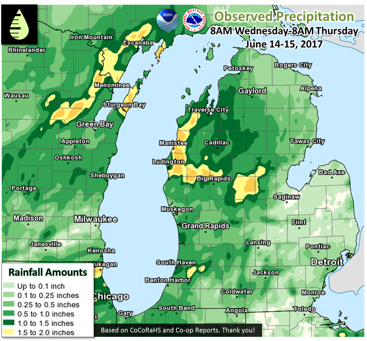
Public Information Statement
National Weather Service Grand Rapids MI
906 AM EDT Thu Jun 15 2017

...Thunderstorm Wind Gusts of 40 mph or Greater...

Location                     Speed     Time/Date       Lat/Lon

...Michigan...

...Allegan County...
2 ESE North Dorr             43 MPH    0813 PM 06/14   42.76N/85.73W
1 ESE North Dorr             43 MPH    0813 PM 06/14   42.76N/85.73W
2 S Holland                  40 MPH    0755 PM 06/14   42.74N/86.11W
W Mich Regional Arpt         40 MPH    0755 PM 06/14   42.74N/86.11W

...Mason County...
7 NNW Ludington              44 MPH    0800 PM 06/14   44.05N/86.51W
Big Sable Point              44 MPH    0800 PM 06/14   44.05N/86.51W

...Ottawa County...
2 SSW Jamestown              47 MPH    0815 PM 06/14   42.80N/85.86W
Holland Harbor               43 MPH    0736 PM 06/14   42.77N/86.21W

...Van Buren County...
2 WSW Gobles                 49 MPH    0840 PM 06/14   42.35N/85.92W

...Maritime Stations...
1 W Grand Haven              55 MPH    0752 PM 06/14   43.06N/86.26W
Ludington Buoy               43 MPH    0750 PM 06/14   44.00N/86.60W

...24 Hour Rainfall Reports of 1.00 inch or Greater...

Location                     Amount    Time/Date       Lat/Lon

...Michigan...

...Allegan County...
Plainwell                    1.51 in   0700 AM 06/15   42.44N/85.65W
Wayland                      1.37 in   0810 AM 06/15   42.66N/85.65W
W Mich Regional Arpt         1.11 in   0753 AM 06/15   42.74N/86.11W

...Eaton County...
Charlotte Fitch Beach Arpt   1.02 in   0754 AM 06/15   42.57N/84.81W

...Isabella County...
Mt Pleasant Muni Arpt        1.79 in   0754 AM 06/15   43.62N/84.74W
Mount Pleasant               1.11 in   0855 AM 06/15   43.59N/84.77W

...Kalamazoo County...
2 NNW Westwood               1.10 in   0920 PM 06/14   42.33N/85.65W
2 E Cooper                   1.05 in   0850 AM 06/15   42.38N/85.55W

...Lake County...
1 S Baldwin                  1.79 in   0838 AM 06/15   43.88N/85.85W

...Mason County...
Scottville 2 SE              2.48 in   0700 AM 06/15   43.93N/86.25W

...Newaygo County...
4 SE Woodville               1.34 in   0700 AM 06/15   43.61N/85.64W

...Osceola County...
Reed City Wwtp               1.96 in   0700 AM 06/15   43.87N/85.50W

...Ottawa County...
1 NNE Beechwood              1.66 in   0854 AM 06/15   42.82N/86.12W
2 NW Beechwood               1.35 in   0730 AM 06/15   42.82N/86.15W

...Van Buren County...
2 WSW Gobles                 2.59 in   0850 AM 06/15   42.35N/85.92W
Bloomingdale                 2.10 in   0425 AM 06/15   42.38N/85.97W
1 ENE Grand Junction         1.40 in   1115 PM 06/14   42.41N/86.05W

Observations are collected from a variety of sources with varying
equipment and exposures. We thank all volunteer weather observers
for their dedication. Not all data listed are considered official.
 |
Media use of NWS Web News Stories is encouraged! |
|

