
Excessive rainfall may produce locally considerable flash flooding over parts of South Texas, the western Gulf Coast, and Lower Mississippi River Valley through Thursday. Hot temperatures will persist over central and northern California and the Pacific Northwest through today. Read More >
Rainfall totals are from the last 72 hours, ending Monday morning.
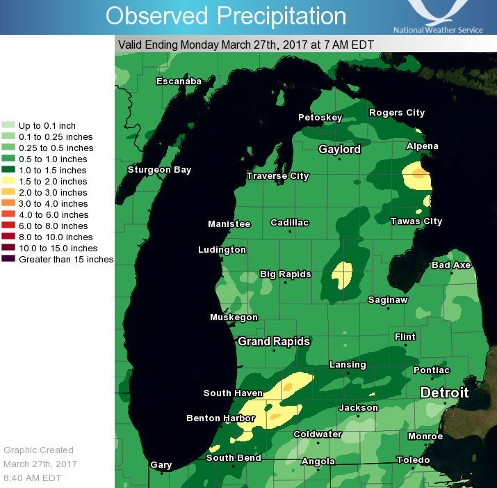
Public Information Statement
National Weather Service Grand Rapids MI
845 AM EDT Mon Mar 27 2017

...Storm Total 72 Hour Rainfall Reports...

Location                     Amount    Time/Date       Lat/Lon

...Michigan...

...Allegan County...
Wayland                      1.95 in   0710 AM 03/27   42.66N/85.65W
3 E Allegan                  1.56 in   0827 AM 03/27   42.52N/85.77W
Allegan                      1.26 in   0833 AM 03/27   42.53N/85.83W
1 W Wayland                  1.04 in   0730 AM 03/27   42.67N/85.68W
Hopkins 1 N                  0.97 in   0700 AM 03/27   42.64N/85.76W
W Mich Regional Arpt         0.83 in   0753 AM 03/27   42.74N/86.11W
1 ESE North Dorr             0.63 in   0833 AM 03/27   42.76N/85.73W
Douglas                      0.36 in   0829 AM 03/27   42.65N/86.23W

...Barry County...
Hastings                     2.22 in   0700 AM 03/27   42.65N/85.30W
1 ENE Irving                 1.44 in   0832 AM 03/27   42.70N/85.40W

...Calhoun County...
1 E Brownlee Park            1.28 in   0830 AM 03/27   42.32N/85.11W
W K Kellogg Airport          1.17 in   0753 AM 03/27   42.31N/85.25W
Marshall Brooks Field        0.47 in   0753 AM 03/27   42.26N/84.96W

...Clare County...
2 SW Leota                   0.70 in   0812 AM 03/27   44.12N/84.92W

...Clinton County...
Capital City Airport         1.30 in   0753 AM 03/27   42.78N/84.59W
1 N Haslett                  1.04 in   0831 AM 03/27   42.77N/84.41W

...Eaton County...
1 SSW Waverly                1.28 in   0700 AM 03/27   42.72N/84.63W
Grand Ledge                  1.25 in   0700 AM 03/27   42.77N/84.77W
Eaton Rapids                 1.00 in   0800 AM 03/27   42.52N/84.65W
Charlotte Fitch Beach Arpt   0.73 in   0755 AM 03/27   42.57N/84.81W

...Gratiot County...
Saint Louis                  0.71 in   1159 PM 03/26   43.40N/84.61W
Wheeler                      0.57 in   0833 AM 03/27   43.41N/84.46W
Alma                         0.55 in   0700 AM 03/27   43.38N/84.67W

...Ingham County...
4 SW Williamston             0.93 in   0800 AM 03/27   42.64N/84.33W
1 ENE Haslett                0.91 in   0833 AM 03/27   42.76N/84.39W
2 SW Okemos                  0.82 in   0832 AM 03/27   42.68N/84.44W
East Lansing                 0.77 in   0837 AM 03/27   42.75N/84.50W
2 SSW East Lansing           0.31 in   0826 AM 03/27   42.70N/84.50W

...Ionia County...
2 NE Saranac                 1.34 in   0630 AM 03/27   42.96N/85.17W
1 SW Ionia                   1.00 in   0745 AM 03/27   42.97N/85.07W
1 SW Portland                0.74 in   0800 AM 03/27   42.86N/84.91W

...Isabella County...
Mount Pleasant               1.26 in   0835 AM 03/27   43.59N/84.77W
Mt Pleasant Muni Arpt        1.13 in   0755 AM 03/27   43.62N/84.74W
1 SSE Mount Pleasant         1.04 in   1155 PM 03/26   43.58N/84.77W
4 SSE Shepherd               0.99 in   0834 AM 03/27   43.47N/84.67W

...Jackson County...
1 ENE Jackson                0.45 in   0700 AM 03/27   42.25N/84.38W
Jackson County-Reynolds Fiel 0.40 in   0756 AM 03/27   42.26N/84.46W
2 WNW Jackson                0.35 in   0828 AM 03/27   42.26N/84.44W
1 ESE Sandstone              0.29 in   0824 AM 03/27   42.24N/84.50W
Leoni                        0.23 in   0830 AM 03/27   42.24N/84.25W

...Kalamazoo County...
Kzoo/battle Creek Intl Airpo 1.48 in   0753 AM 03/27   42.23N/85.55W

...Kent County...
Nws Forecast Office Grand Ra 1.01 in   0800 AM 03/27   42.89N/85.54W
2 NE Caledonia               0.97 in   0730 AM 03/27   42.82N/85.48W
Gerald R Ford Intl           0.97 in   0753 AM 03/27   42.89N/85.54W
1 SSW Comstock Park          0.96 in   0825 AM 03/27   43.03N/85.68W
1 WSW Kentwood               0.85 in   0600 AM 03/27   42.87N/85.62W
Grandville                   0.83 in   0700 AM 03/27   42.90N/85.77W
1 WSW Grandville             0.81 in   0700 AM 03/27   42.90N/85.78W
2 N Cannonsburg              0.78 in   0832 AM 03/27   43.09N/85.47W
Rockford                     0.78 in   0700 AM 03/27   43.12N/85.56W
Grandville                   0.77 in   0824 AM 03/27   42.91N/85.76W
1 SSW Ada                    0.75 in   0834 AM 03/27   42.94N/85.50W
Cutlerville                  0.75 in   0833 AM 03/27   42.84N/85.66W
Walker                       0.67 in   0826 AM 03/27   42.98N/85.74W
2 SE Cedar Springs           0.67 in   0135 AM 03/27   43.19N/85.51W
2 ENE Belmont                0.60 in   0832 AM 03/27   43.09N/85.57W
2 S Grand Rapids             0.59 in   0834 AM 03/27   42.93N/85.65W
2 SW East Grand Rapids       0.44 in   1244 AM 03/27   42.92N/85.64W

...Lake County...
1 S Baldwin                  0.32 in   0838 AM 03/27   43.88N/85.85W

...Mason County...
5 NNE Ludington              0.84 in   0832 AM 03/27   44.03N/86.41W
3 SSE Ludington              0.61 in   0821 AM 03/27   43.91N/86.42W
Mason Co Apt                 0.51 in   0755 AM 03/27   43.97N/86.42W

...Mecosta County...
3 NNW Stanwood               0.57 in   0700 AM 03/27   43.63N/85.48W
Big Rapids Water Works       0.48 in   0700 AM 03/27   43.70N/85.48W

...Montcalm County...
3 ESE Mcbride                1.07 in   0700 AM 03/27   43.31N/84.99W

...Muskegon County...
Lakewood Club                0.58 in   0835 AM 03/27   43.37N/86.24W
Muskegon County Airport      0.40 in   0755 AM 03/27   43.17N/86.24W
1 WSW Norton Shores          0.32 in   0406 AM 03/27   43.16N/86.27W
Norton Shores                0.30 in   0835 AM 03/27   43.17N/86.26W
1 WSW Norton Shores          0.26 in   1242 AM 03/27   43.15N/86.29W
Whitehall Lighthouse         0.22 in   0833 AM 03/27   43.37N/86.42W
1 WSW Norton Shores          0.13 in   0408 AM 03/27   43.15N/86.28W

...Newaygo County...
Croton                       0.62 in   0830 AM 03/27   43.43N/85.67W
1 S Newaygo                  0.54 in   0833 AM 03/27   43.40N/85.80W
4 WSW Fremont                0.48 in   0700 AM 03/27   43.45N/86.03W

...Oceana County...
Hart                         0.39 in   0700 AM 03/27   43.70N/86.37W
Pentwater                    0.35 in   0833 AM 03/27   43.78N/86.43W
3 ENE Pentwater              0.35 in   0822 AM 03/27   43.81N/86.38W

...Osceola County...
2 SE Hersey                  0.40 in   0839 AM 03/27   43.82N/85.41W

...Ottawa County...
1 NNE Holland                0.81 in   0825 AM 03/27   42.79N/86.10W
1 NNE Beechwood              0.77 in   0834 AM 03/27   42.82N/86.12W
Hudsonville                  0.65 in   0835 AM 03/27   42.87N/85.87W
Grand Haven Wwtp             0.48 in   0700 AM 03/27   43.07N/86.20W
1 ESE Spring Lake            0.47 in   0835 AM 03/27   43.06N/86.17W
2 W Nunica                   0.39 in   0835 AM 03/27   43.08N/86.13W
1 NW Grand Haven             0.34 in   0820 AM 03/27   43.08N/86.25W

...Van Buren County...
Bloomingdale                 2.06 in   0600 AM 03/27   42.38N/85.97W
2 WSW Gobles                 1.88 in   0830 AM 03/27   42.35N/85.92W
3 NNE Paw Paw                1.79 in   0700 AM 03/27   42.27N/85.86W
1 ENE Grand Junction         1.49 in   0827 AM 03/27   42.41N/86.05W
1 E Lawton                   1.25 in   0830 AM 03/27   42.17N/85.82W

Observations are collected from a variety of sources with varying
equipment and exposures. Not all data listed are considered official.
From lake-effect snow to summer thunderstorms, precipitation in Michigan certainly does not fall the same on all! It's your reports that help us paint a clearer picture of how much has fallen in different locations.
The Community Collaborative Rain, Hail & Snow Network (CoCoRaHS) is one way to send your rain, snow, and hail measurements to the National Weather Service and many other interested organizations. Using similar rain gauges and reporting in roughly the same time frame each morning, thousands of CoCoRaHS volunteers across the country help create a consistent and reliable understanding of the previous 24-hour's precipitation amounts.
Your daily CoCoRaHS reports are automatically delivered to your local National Weather Service office, where detailed rain & snowfall maps can be created, and river level & flood forecasts can be improved. You might even see your report being used in an on-air broadcast!

 |
Media use of NWS Web News Stories is encouraged! |
|

