
Thunderstorms later in the day Sunday could produce locally strong or damaging wind gusts, isolated large hail, and a brief tornado or two within the southern half of Lower Michigan. Read More >
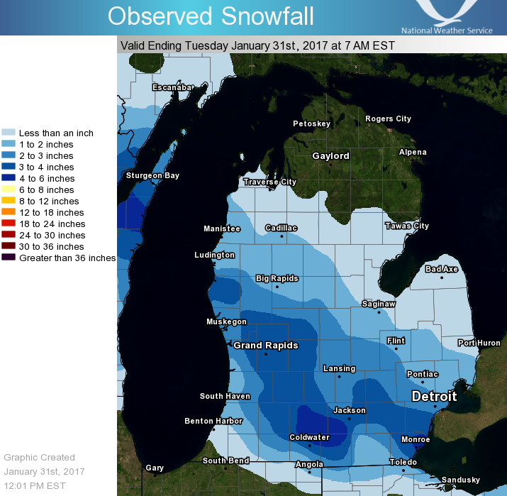
Just about everyone received measurable snow from an Alberta Clipper that moved through the Great Lakes region. This led to some slick roads, especially overnight Monday into Tuesday morning. The graphic below is based on reports received as of 7am Tuesday. It does not capture every local report, and so it may be slightly different than what you received in your area. However, generally most areas received 2"-5" of new snow from this system.
Below are some selected reports we received from the public, media, and trained spotters. Thank you also to those who sent us reports on Facebook and Twitter!
Public Information Statement
National Weather Service Grand Rapids MI
1146 AM EST Tue Jan 31 2017

...Snowfall Reports...

Location                     Amount    Time/Date       Lat/Lon

...Michigan...

...Allegan County...
Plainwell                    3.9 in    0730 AM 01/31   42.44N/85.65W
1 W Wayland                  3.1 in    0730 AM 01/31   42.67N/85.68W
Hopkins 1 N                  2.2 in    0700 AM 01/31   42.64N/85.76W

...Barry County...
2 ESE Assyria                4.1 in    0700 AM 01/31   42.45N/85.10W
Hastings                     3.5 in    0700 AM 01/31   42.65N/85.30W
Plainwell 5.4 E              3.3 in    0800 AM 01/31   42.45N/85.54W

...Clare County...
8 SW Skeels                  1.3 in    0800 AM 01/31   43.99N/84.70W

...Clinton County...
1 W Dewitt                   3.5 in    0700 AM 01/31   42.83N/84.60W
1 N Haslett                  2.9 in    0700 AM 01/31   42.77N/84.40W
Saint Johns                  2.3 in    0750 AM 01/31   43.02N/84.55W
Capital City Airport         2.1 in    0653 AM 01/31   42.78N/84.59W

...Eaton County...
Eaton Rapids                 3.0 in    0800 AM 01/31   42.52N/84.65W
Grand Ledge                  3.0 in    0700 AM 01/31   42.77N/84.77W
1 SSW Waverly                2.1 in    0700 AM 01/31   42.73N/84.63W

...Gratiot County...
Alma                         1.9 in    0700 AM 01/31   43.38N/84.67W
Saint Louis                  1.8 in    1159 PM 01/30   43.40N/84.61W

...Ingham County...
1 WSW Lansing                3.5 in    0700 AM 01/31   42.70N/84.59W
1 ENE Edgemont Park          3.5 in    0800 AM 01/31   42.76N/84.56W
1 NNW Okemos                 3.2 in    0930 AM 01/31   42.72N/84.42W
4 NNW Dansville              3.2 in    0700 AM 01/31   42.61N/84.34W

...Ionia County...
2 NE Saranac                 3.4 in    0630 AM 01/31   42.96N/85.17W

...Isabella County...
4 SSE Shepherd               2.2 in    0600 AM 01/31   43.47N/84.67W

...Jackson County...
1 ESE Pulaski                5.2 in    0732 AM 01/31   42.11N/84.63W
3 SE Sandstone               3.5 in    0745 AM 01/31   42.22N/84.47W
2 NNE Topkins                2.2 in    0900 AM 01/31   42.41N/84.53W

...Kalamazoo County...
Oshtemo                      3.5 in    1121 AM 01/31   42.26N/85.68W

...Kent County...
1 W Ada                      5.2 in    0800 AM 01/31   42.95N/85.53W
Rockford                     4.5 in    1100 AM 01/31   43.14N/85.55W
2 WNW Belmont                4.3 in    0600 AM 01/31   43.09N/85.64W
1 W Grattan                  4.0 in    0745 AM 01/31   43.08N/85.40W
2 E Walker                   4.0 in    0900 AM 01/31   42.99N/85.69W
2 N Cannonsburg              4.0 in    0700 AM 01/31   43.09N/85.47W
NWS Grand Rapids             3.9 in    0700 AM 01/31   42.89N/85.54W
Grandville                   3.5 in    0615 AM 01/31   42.90N/85.77W
1 ESE East Grand Rapids      3.5 in    0700 AM 01/31   42.93N/85.58W
Lowell Wwtp                  3.4 in    0800 AM 01/31   42.93N/85.33W
East Grand Rapids            3.4 in    0700 AM 01/31   42.94N/85.61W
1 SSW Dutton                 3.1 in    0620 AM 01/31   42.83N/85.59W
2 WSW Kentwood               3.0 in    0730 AM 01/31   42.87N/85.62W

...Mason County...
Scottville 2 SE              2.1 in    0700 AM 01/31   43.93N/86.25W
6 NW Scottville              1.1 in    0500 AM 01/31   44.04N/86.34W

...Mecosta County...
3 NNW Stanwood               2.3 in    0700 AM 01/31   43.63N/85.48W
2 NW Sylvester               2.0 in    0800 AM 01/31   43.56N/85.28W
Big Rapids Water Works       1.6 in    0700 AM 01/31   43.70N/85.48W

...Montcalm County...
3 ESE Mcbride                3.0 in    0700 AM 01/31   43.31N/84.99W

...Muskegon County...
Muskegon County Airport      2.5 in    0655 AM 01/31   43.17N/86.24W

...Newaygo County...
4 WSW Fremont                3.0 in    0700 AM 01/31   43.45N/86.03W
4 SE Woodville               2.4 in    0700 AM 01/31   43.61N/85.64W

...Oceana County...
Hart                         3.9 in    0700 AM 01/31   43.70N/86.37W
Mears                        3.9 in    0700 AM 01/31   43.67N/86.42W
4 SSE Stony Lake             1.5 in    0700 AM 01/31   43.50N/86.47W

...Osceola County...
Reed City Wwtp               1.3 in    0700 AM 01/31   43.87N/85.50W

...Ottawa County...
1 SSW Allendale              3.0 in    0800 AM 01/31   42.97N/85.96W
2 NW Beechwood               2.1 in    0730 AM 01/31   42.82N/86.15W
Holland                      1.0 in    0630 AM 01/31   42.80N/86.12W

...Van Buren County...
3 NNE Paw Paw                2.5 in    0700 AM 01/31   42.27N/85.86W
Bloomingdale                 2.0 in    0500 AM 01/31   42.38N/85.97W

Observations are collected from a variety of sources with varying
equipment and exposures. Not all data listed are considered official.
 |
Media use of NWS Web News Stories is encouraged! |
|

