
Clouds will increase on Thursday, with a chance of storms developing Thursday night. Temperatures will then warm into the 70s on Friday with strong to severe storms possible. Read More >
Grand Rapids, MI
Weather Forecast Office
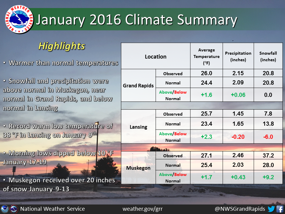
January 2016 temperatures in the southwest quarter of Lower Michigan averaged 1-2 degrees above normal. Snowfall and precipitation were above normal in Muskegon, near normal in Grand Rapids, and below normal in Lansing.
There were several temperature swings between cold and mild during the month, but overall there were very few extremes. Lansing set a record warm low temperature on the 9th. A few days featured temperatures dipping below 10 degrees and highs remaining in the teens. The end of the month was quite mild with temperatures in the 40s to around 50.
Following a record warm December, Lake Michigan water temperatures in the low 40s in early to mid January afforded the atmosphere opportunities to produce significant lake-effect snow when polar air masses moved in from the northwest. Heavy lake-effect snow did indeed occur on a couple occasions and mainly favored the northwest and southwest wind snow belts. Muskegon received over 20 inches of snow between the 9th and 13th from both lake-effect and lake-enhanced low pressure systems. An additional foot of snow fell between the 17th and 20th. Various low pressure systems produced rain and occasional accumulations of snow for all areas, though no memorable winter storm occurred.
US Dept of Commerce
National Oceanic and Atmospheric Administration
National Weather Service
Grand Rapids, MI
4899 Tim Dougherty Drive SE
Grand Rapids, MI 49512-4034
616-949-0643
Comments? Questions? Please Contact Us.

