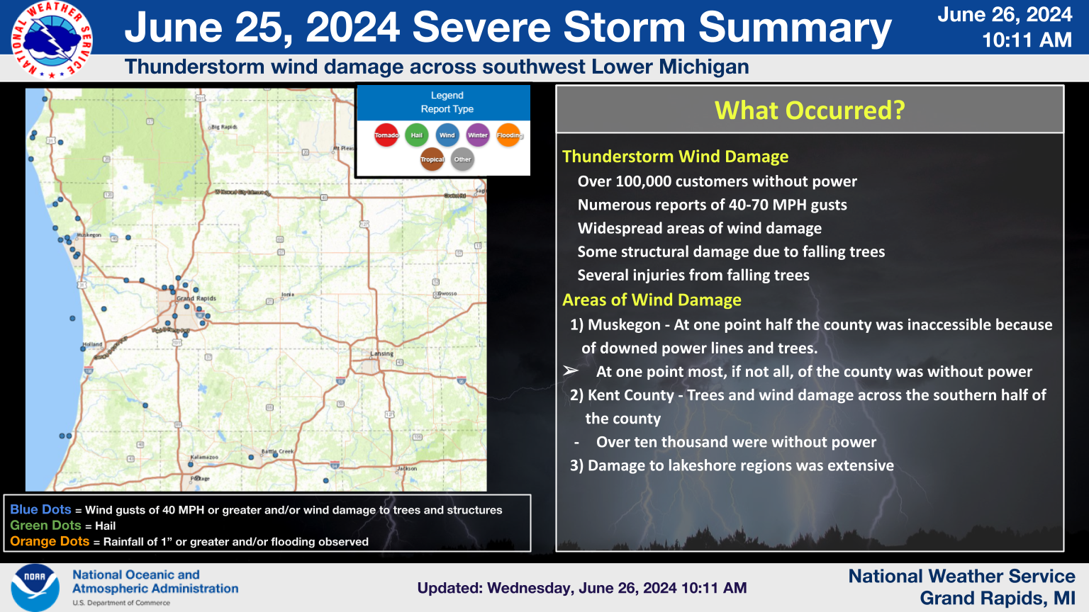
Overview
A line of severe thunderstorms moved through Western Lower Michigan during the early morning hours of June 25, 2024. Extensive wind damage occurred along the Lake Michigan lakeshore, starting near Pentwater and Silver Lake in Oceana County, and spreading south-southeast through Muskegon County, where Whitehall and Muskegon were particularly hard-hit by winds measured between 60 and 70 mph, estimated in some spots to be over 80 mph. Some hail ranging from dime to quarter size was reported as well, but the main impacts came from wind damage to trees and powerlines that then resulted in power outages affecting many thousands.
After storms passed, winds remained strong and erratic in direction thanks to a "wake low" phenomenon that occurred behind (or in the wake of) the exiting storms. Large and rapid pressure changes associated with the wake low produced fluctuations in the height of water levels along the southeastern and southern Lake Michigan shoreline.
Radar
NWS Grand Rapids Radar Loop from 3 AM to 11 AM EDT June 25, 2024
NWS Grand Rapids Radar Velocity Loop from 5 AM to 8 AM EDT June 25, 2024
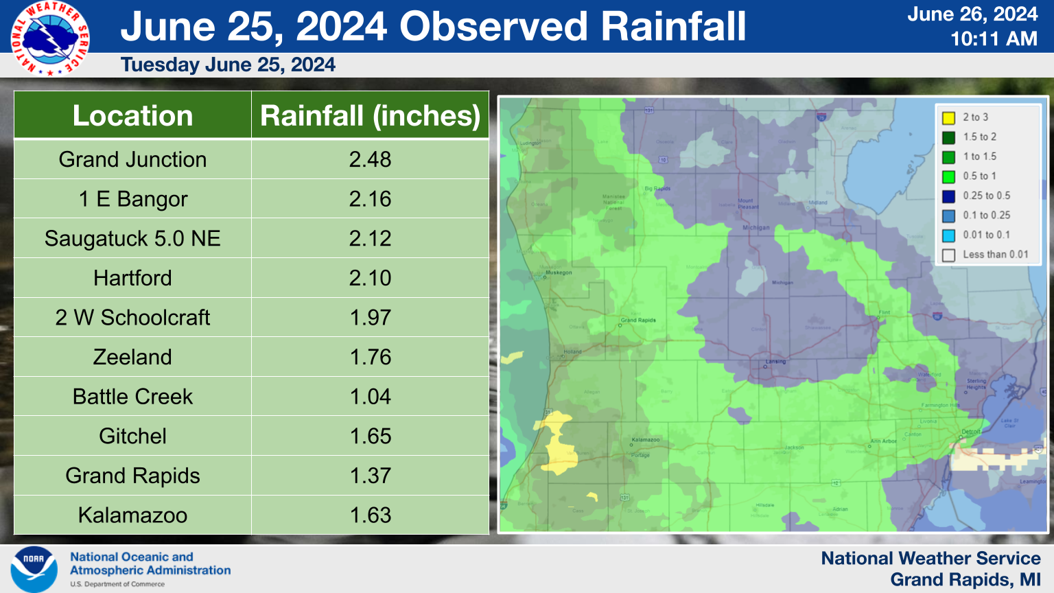
Damage and Rainfall maps
 |
 |
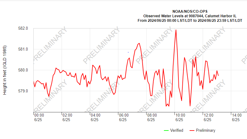
Fluctuating Lake Michigan Water Levels
Strong winds and rapidly changing air pressure caused water levels along the lakeshore to fluctuate rapidly. The greatest effects were observed at Calumet Harbor by Chicago. The accumulating effects of the squall line along the Lake Michigan coast wrapped around the Lake. Between approximately 10 AM CDT and 10:30 AM CDT, the water level dropped well over 3 feet! This presents a dangerous setup for rip currents since a large amount of water is already retreating from the lakeshore.
You can check Lake Michigan water levels yourself by visiting the NOAA Tides and Currents website.
 |
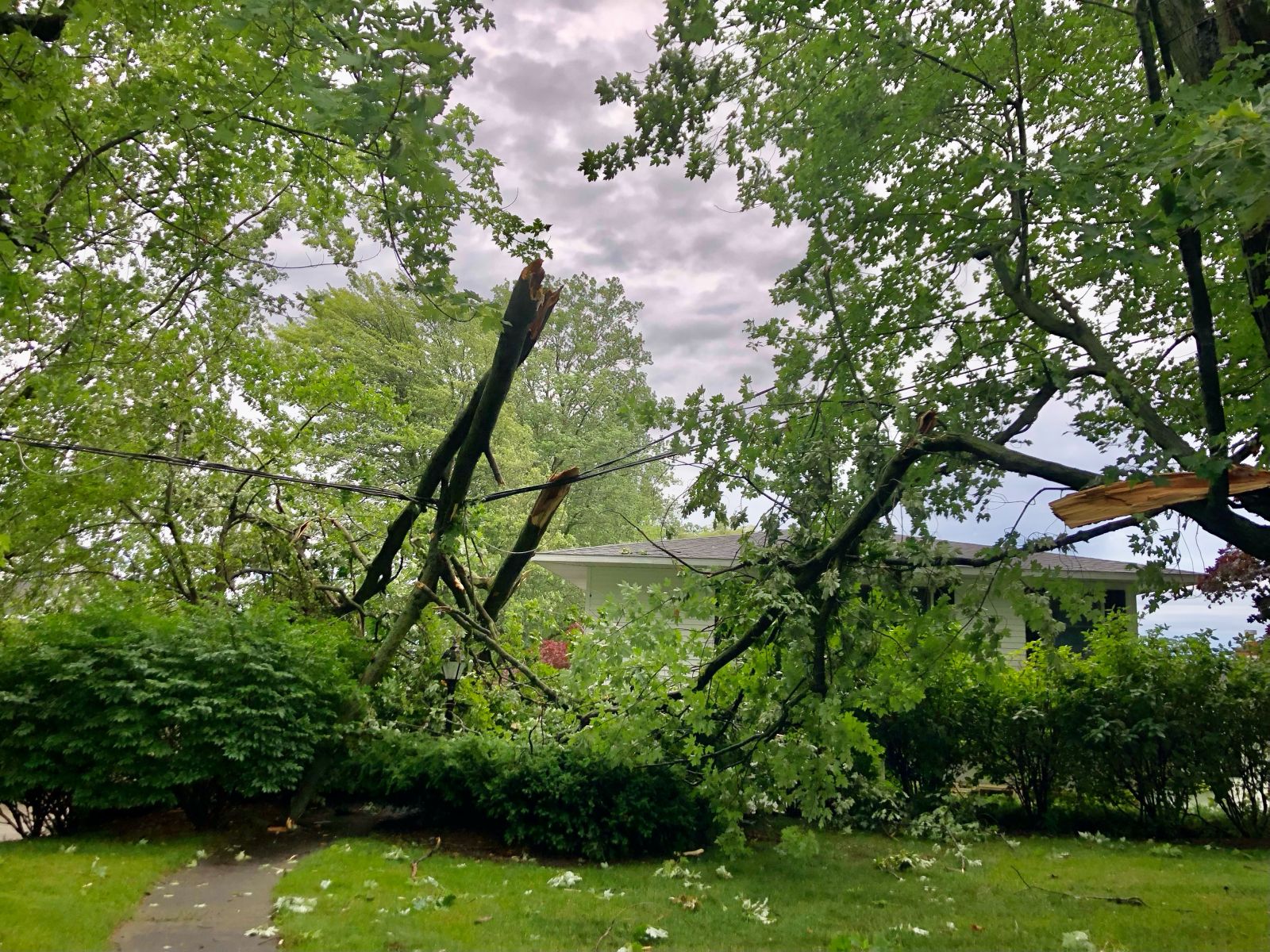
Photos & Video
Muskegon Area
 |
 |
.jpeg) |
 |
|
Pointe Marine Storage Building, North Muskegon (Traci Jones) |
Pointe Marine (Traci Jones) | Pointe Marine (Traci Jones) |
Lake Ave, North Muskegon (Traci Jones) |
.JPEG) |
.jpeg) |
||
|
Muskegon Nims Neighborhood (Sandy Coyne) |
Muskegon Nims Neighborhood (Bob Delong) |
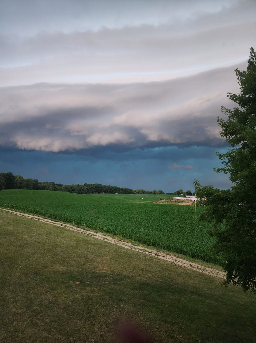
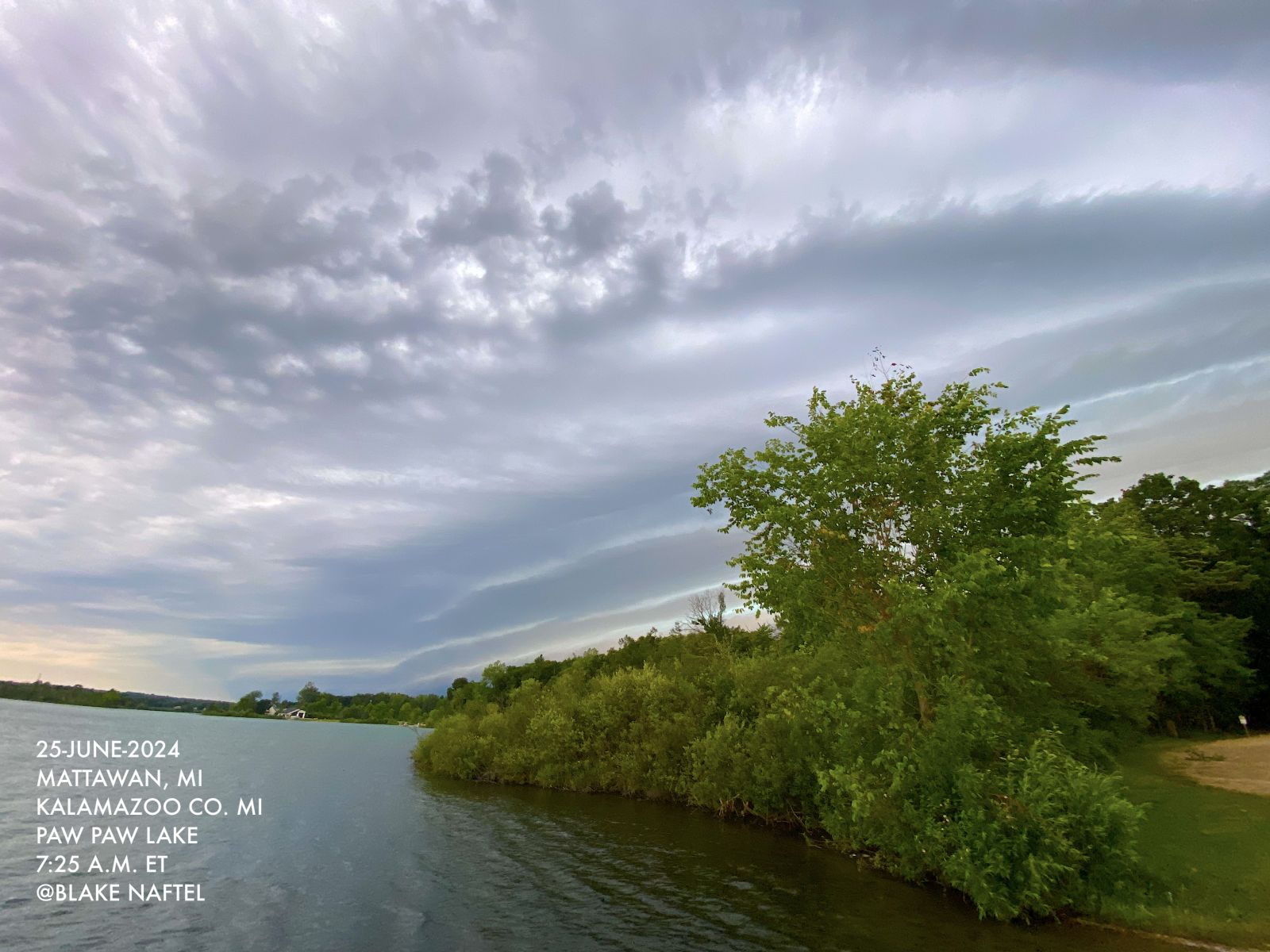
Shelf Cloud Pictures
 |
 |
 |
|
| Allegan, MI (RoxAnne Briles-Heasley) |
Mattawan, MI (Blake Naftel) |
Mattawan, MI (Blake Naftel) |
Storm Reports
Public Information Statement
National Weather Service Grand Rapids MI
203 PM EDT Tue Jun 25 2024

...HIGHEST WIND REPORTS...

Location                     Speed     Time/Date       Lat/Lon

...Michigan...

...Calhoun County...
1 SSW Springfield            60 MPH    0735 AM 06/25   42.31N/85.24W

...Kalamazoo County...
2 ENE Portage                54 MPH    1019 AM 06/25   42.22N/85.55W

...Kent County...
3 SSW Comstock Park          68 MPH    0635 AM 06/25   43.01N/85.69W
East Grand Rapids            52 MPH    0636 AM 06/25   42.95N/85.61W
2 SSW Cascade                51 MPH    0643 AM 06/25   42.88N/85.52W

...Muskegon County...
1 NE Norton Shores           71 MPH    0604 AM 06/25   43.17N/86.24W
Norton Shores                70 MPH    0600 AM 06/25   43.16N/86.25W
4 WNW Roosevelt Park         68 MPH    0558 AM 06/25   43.23N/86.34W
2 SW Whitehall               58 MPH    0554 AM 06/25   43.38N/86.37W

...Oceana County...
1 NW Stony Lake              68 MPH    0539 AM 06/25   43.57N/86.51W
2 N Pentwater                49 MPH    0459 AM 06/25   43.82N/86.43W

...Ottawa County...
1 WSW Coopersville           54 MPH    0624 AM 06/25   43.06N/85.96W

...Maritime Stations...
Macatawa                     65 MPH    0636 AM 06/25   42.77N/86.21W
South Haven                  54 MPH    0724 AM 06/25   42.40N/86.29W
4 W Port Sheldon             44 MPH    0630 AM 06/25   42.90N/86.27W
3 W South Haven              44 MPH    0730 AM 06/25   42.40N/86.33W
South Haven                  41 MPH    0948 AM 06/25   42.40N/86.29W
Southern Lake Michigan Buoy  40 MPH    0900 AM 06/25   42.67N/87.03W
8 NNW Ludington              40 MPH    0530 AM 06/25   44.06N/86.51W
----------------------------------------------------------------------

0500 AM     Tstm Wnd Dmg     2 NE Shelby             43.64N 86.34W
06/25/2024                   Oceana             MI   Public

            Large tree partially fell on house.

0535 AM     Tstm Wnd Dmg     2 NE Little Point Sable 43.66N 86.50W
06/25/2024                   Oceana             MI   Public

            Tree trunk fell through a premanufactured
            home. Snapped tree limb fell partially
            through a shed.

0535 AM     Tstm Wnd Dmg     4 W Mears               43.68N 86.49W
06/25/2024                   Oceana             MI   Public

            Tree limbs fallen and damaged camper trailer
            and vehicle. Other trees uprooted. Power
            outages in the area.

0550 AM     Tstm Wnd Dmg     Whitehall               43.40N 86.34W
06/25/2024                   Muskegon           MI   Public

            Trees uprooted with damage to a parked
            school bus. Tree limb snapped and fell on a
            pickup truck.

0554 AM     Tstm Wnd Dmg     6 WSW Dalton            43.28N 86.37W
06/25/2024                   Muskegon           MI   Broadcast Media

            Limbs snapped and trees down at Pioneer
            County Park. Trees damaged tents and camper
            trailers.

0555 AM     Tstm Wnd Dmg     1 ENE Dalton            43.32N 86.24W
06/25/2024                   Muskegon           MI   Law Enforcement

            About half of local roads in northern and
            central Muskegon County impassable due to
            fallen trees and power lines.

0559 AM     Tstm Wnd Dmg     North Muskegon          43.24N 86.30W
06/25/2024                   Muskegon           MI   Broadcast Media

            Boat storage building roof lifted and walls
            collapsed.

0600 AM     Tstm Wnd Dmg     2 NNW Roosevelt Park    43.22N 86.29W
06/25/2024                   Muskegon           MI   Public

            Large tree crushing a car. Damage to power
            pole and lines down.

0601 AM     Tstm Wnd Dmg     Roosevelt Park          43.19N 86.27W
06/25/2024                   Muskegon           MI   Public

            Trees uprooted.

0608 AM     Tstm Wnd Dmg     3 N Ravenna             43.24N 85.95W
06/25/2024                   Muskegon           MI   Trained Spotter

            Multiple trees down.

0620 AM     Tstm Wnd Dmg     3 NW Marne              43.06N 85.87W
06/25/2024                   Ottawa             MI   Public

            Wood sided barn shifted with sections of
            exterior walls structurally failed and parts
            of metal roofing peeled.

0627 AM     Tstm Wnd Dmg     3 N Walker              43.03N 85.74W
06/25/2024                   Kent               MI   Trained Spotter

            4 mile road and Peach Ridge Avenue two 20
            inch diameter trees down.

0628 AM     Tstm Wnd Dmg     3 N Walker              43.03N 85.74W
06/25/2024                   Kent               MI   Trained Spotter

            Six 10 inch diameter trees blocking West
            bound 4 mile lane.

0630 AM     Tstm Wnd Dmg     2 N Olive Center        42.94N 86.09W
06/25/2024                   Ottawa             MI   Trained Spotter

            Street light knocked over by wind.

0635 AM     Tstm Wnd Dmg     5 SE Belmont            43.02N 85.56W
06/25/2024                   Kent               MI   Trained Spotter

            Tree landed on a shed.

0635 AM     Tstm Wnd Dmg     1 WSW Wyoming           42.88N 85.72W
06/25/2024                   Kent               MI   Trained Spotter

            12 inch Diameter tree down on house.

0637 AM     Tstm Wnd Dmg     1 NE Wyoming            42.91N 85.68W
06/25/2024                   Kent               MI   Trained Spotter

            20 inch diameter tree down on road.

0640 AM     Tstm Wnd Dmg     3 WSW Ada               42.94N 85.54W
06/25/2024                   Kent               MI   Public

            Tree on a house.

0640 AM     Tstm Wnd Dmg     2 NNE Comstock Park     43.07N 85.66W
06/25/2024                   Kent               MI   Trained Spotter

            Large tree limbs down.

0642 AM     Tstm Wnd Dmg     1 NE Wyoming            42.91N 85.68W
06/25/2024                   Kent               MI   Trained Spotter

            20 inch diameter tree on home. Time
            estimated from radar.

0644 AM     Tstm Wnd Dmg     2 ESE Cutlerville       42.83N 85.62W
06/25/2024                   Kent               MI   Trained Spotter

            10 to 12 inch diameter tree down in road.

0649 AM     Tstm Wnd Dmg     2 WSW Comstock Park     43.03N 85.70W
06/25/2024                   Kent               MI   Trained Spotter

            Numerous reports of large limbs down and
            entire trees down along 4 Mile Rd in Alpine
            Township.

0656 AM     Tstm Wnd Dmg     1 WSW Wyoming           42.88N 85.72W
06/25/2024                   Kent               MI   Trained Spotter

            1 foot diameter tree down on house.

0658 AM     Tstm Wnd Dmg     2 ESE Cutlerville       42.83N 85.62W
06/25/2024                   Kent               MI   Trained Spotter

            1 foot diameter tree and power lines down.

0700 AM     Tstm Wnd Dmg     1 SE Cascade            42.91N 85.49W
06/25/2024                   Kent               MI   Public

            Two roofs damaged by large limbs.

0728 AM     Tstm Wnd Dmg     Allegan                 42.53N 85.85W
06/25/2024                   Allegan            MI   Emergency Mngr

            Trees and wires down across Allegan County.

0754 AM     Tstm Wnd Dmg     Kalamazoo               42.28N 85.59W
06/25/2024                   Kalamazoo          MI   Emergency Mngr

            Scattered trees and power lines down across
            Kalamazoo County.

0824 AM     Tstm Wnd Dmg     4 SW Albion             42.21N 84.81W
06/25/2024                   Calhoun            MI   Trained Spotter

            1 foot diameter tree covering road.

0842 AM     Tstm Wnd Dmg     2 ESE Brownlee Park     42.32N 85.10W
06/25/2024                   Calhoun            MI   Emergency Mngr

            Tree down on power lines.
0525 AM     Hail             1 NNW Roosevelt Park    43.21N 86.28W
06/25/2024  E1.00 Inch       Muskegon           MI   Public

            report via mping.

0532 AM     Hail             2 WSW Cloverville       43.18N 86.20W
06/25/2024  E0.50 Inch       Muskegon           MI   Public

            report via mping.

0618 AM     Hail             2 SSW Grandville        42.88N 85.78W
06/25/2024  E0.70 Inch       Kent               MI   Public

            report via mping. time estimated by radar.

0626 AM     Hail             1 N Cutlerville         42.85N 85.66W
06/25/2024  E0.70 Inch       Kent               MI   Public

            report via mping. time estimated by radar.

0633 AM     Hail             1 NNE Dutton            42.86N 85.58W
06/25/2024  E0.70 Inch       Kent               MI   Public

            report via mping. time estimated by radar.

0750 AM     Hail             2 WSW Kalamazoo         42.27N 85.63W
06/25/2024  E0.50 Inch       Kalamazoo          MI   Public

            report via mping. time estimated by radar.

0750 AM     Hail             2 SSW Springfield       42.30N 85.25W
06/25/2024  E0.50 Inch       Calhoun            MI   Public

            report via mping. time estimated by radar.
0549 AM Tstm Wnd Dmg 1 SW Whitehall 43.39N 86.35W
06/25/2024 Muskegon MI Public
Numerous large trees uprooted or limbs
snapped in Country Club Rd neighborhood.
Trees pulled down wires, snapped power
poles, damaged vehicles and houses.
0549 AM Tstm Wnd Dmg 1 SW Whitehall 43.39N 86.36W
06/25/2024 Muskegon MI Public
Tree fell through second floor of house.
Many hardwood trees uprooted. Roads blocked
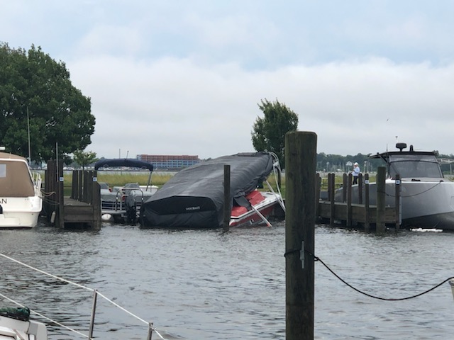
by trees. Pontoon boat flipped at the dock.
Near South Shore Drive and White Lake Drive.
0528 AM     Tstm Wnd Dmg     Pentwater               43.78N 86.43W
06/25/2024                   Oceana             MI   Public

            Trees and power lines down at 9 different
            intersections in the village of Pentwater.
            Reported by Chamber of Commerce.

0558 AM     Tstm Wnd Dmg     3 E Hesperia            43.57N 85.98W
06/25/2024                   Newaygo            MI   Public

            Tree across road on Green Ave north of M-20.
0548 AM     Tstm Wnd Dmg     1 SSW Montague          43.40N 86.37W
06/25/2024                   Muskegon           MI   Local Official

            Trees and wires blocking roads in southern
            part of city of Montague.

0608 AM     Tstm Wnd Dmg     Fruitport               43.13N 86.16W
06/25/2024                   Muskegon           MI   Public

            Tree on a house. Roof punctured. Other trees
            and power lines down around Fruitport.

0611 AM     Tstm Wnd Dmg     1 NE Spring Lake        43.08N 86.17W
06/25/2024                   Ottawa             MI   Public

            Several trees down at Spring Lake Country
            Club.

0613 AM     Tstm Wnd Dmg     Grand Haven             43.06N 86.23W
06/25/2024                   Ottawa             MI   Newspaper

            Trees fell on power lines and snapped at
            least one power pole.
 |
Media use of NWS Web News Stories is encouraged! Please acknowledge the NWS as the source of any news information accessed from this site. |
|

