Overview
March 1, 2016 Storm Summary
A winter storm strengthened as its low pressure center tracked east-northeastward just south of Lower Michigan on Tuesday, March 1, 2016. A swath of 8-12 inches of snow, with localized amounts over a foot, fell from Southwest Lower Michigan into the Thumb region. The winter storm featured two main rounds of heavier snow, separated by a 2-3 hour period of light freezing rain and sleet mainly south of Interstate 96. The freezing rain was enough to coat vehicles in a thin layer of ice. No significant power outages were noted. The freezing rain and sleet occurred from late morning into early afternoon as the low pressure center tracked closest to Michigan. A thin layer of warm air well above the ground was able to melt snowflakes, but surface temperatures in the lower 20s resulted in freezing rain and sleet rather than just plain rain. The atmosphere sufficiently cooled by mid-afternoon and changed the precipitation back to all snow. A significant burst of heavy snow during the afternoon hours brought traffic to a crawl.
Storm Impacts
48-Hour Observed Snowfall Map
.png)
Note: this map is a general interpolation of actual snowfall reports from multiple sources. The map shows the best approximation of observed snowfall but should not be considered exact. This map shows snowfall that accumulated in a 48-hour period leading up to 7 AM EST on March 2, 2016. The March 1, 2016 Winter Storm did not produce all of the higher snow totals in Northern Lower Michigan. Much of these higher totals are due to lake-effect snow off Lake Huron on February 29, 2016.
Radar Loop of the Event: 9:00 PM Monday 02/29 through 1:30 AM Wednesday 03/02
.gif)
List of Winter Storm Reports
PUBLIC INFORMATION STATEMENT
NATIONAL WEATHER SERVICE GRAND RAPIDS MI
1119 AM EST WED MAR 2 2016

...MARCH 1 WINTER STORM REPORTS...

...FREEZING RAIN REPORTS...

LOCATION                     AMOUNT    TIME/DATE       LAT/LON

...KALAMAZOO COUNTY...
KALAMAZOO                    0.10 IN   0200 PM 03/01   42.27N/85.59W

...OTTAWA COUNTY...
1 NW HUDSONVILLE             0.05 IN   0230 PM 03/01   42.88N/85.88W

...STORM TOTAL SNOWFALL REPORTS...

LOCATION                     AMOUNT    TIME/DATE       LAT/LON

...ALLEGAN COUNTY...
PLAINWELL                    12.0 IN   0700 PM 03/01   42.45N/85.64W
HOPKINS                      8.0 IN    0700 PM 03/01   42.63N/85.76W

...BARRY COUNTY...
3 NW DELTON                  14.0 IN   0900 PM 03/01   42.53N/85.45W
4 SSW HASTINGS               14.0 IN   0700 AM 03/02   42.59N/85.32W
HASTINGS                     13.1 IN   0700 AM 03/02   42.65N/85.30W

...CALHOUN COUNTY...
2 SW BEDFORD                 8.7 IN    0700 PM 03/01   42.37N/85.26W
1 SE BROWNLEE PARK           5.0 IN    0500 PM 03/01   42.31N/85.11W

...CLINTON COUNTY...
SAINT JOHNS                  10.0 IN   0600 PM 03/01   43.00N/84.56W
2 S BATH                     9.3 IN    1115 PM 03/01   42.79N/84.45W

...EATON COUNTY...
GRAND LEDGE                  9.0 IN    0800 PM 03/01   42.75N/84.75W
SUNFIELD                     9.0 IN    1000 PM 03/01   42.76N/84.99W
1 SSW WAVERLY                8.8 IN    0634 AM 03/02   42.73N/84.62W
LANSING 3.8 WNW              7.5 IN    0700 AM 03/02   42.72N/84.63W
LANSING 4WSW SNOW PAID       7.2 IN    0100 AM 03/02   42.72N/84.63W
BELLEVUE                     7.0 IN    0738 AM 03/02   42.44N/85.02W

...GRATIOT COUNTY...
ALMA                         8.8 IN    0700 AM 03/02   43.38N/84.65W
BRECKENRIDGE                 8.8 IN    0700 AM 03/02   43.41N/84.47W

...INGHAM COUNTY...
4 NNW DANSVILLE              9.1 IN    1000 PM 03/01   42.61N/84.34W
4 SSW OKEMOS                 9.0 IN    0915 PM 03/01   42.65N/84.44W
OKEMOS                       8.3 IN    1005 PM 03/01   42.71N/84.41W
1 WNW EAST LANSING           8.1 IN    0815 PM 03/01   42.74N/84.51W

...IONIA COUNTY...
3 NE SARANAC                 10.3 IN   0630 AM 03/02   42.96N/85.17W

...ISABELLA COUNTY...
3 NNE FOREST HILL            6.9 IN    0600 AM 03/02   43.48N/84.67W
2 SE MOUNT PLEASANT          6.0 IN    0430 PM 03/01   43.58N/84.75W

...JACKSON COUNTY...
RIVES JUNCTION               7.5 IN    1031 AM 03/02   42.39N/84.46W
RIVES JUNCTION 4.0 NW        6.9 IN    0900 AM 03/02   42.41N/84.53W
4 NNE SANDSTONE              5.0 IN    1030 PM 03/01   42.31N/84.48W

...KALAMAZOO COUNTY...
COOPER                       10.5 IN   0525 PM 03/01   42.38N/85.61W
WESTERN MICHIGAN UNIVERSITY  9.6 IN    1159 PM 03/01   42.28N/85.61W
2 S ALAMO                    9.3 IN    0530 PM 03/01   42.35N/85.71W
2 SSE KALAMAZOO              8.5 IN    1000 PM 03/01   42.25N/85.57W
PORTAGE                      8.3 IN    0600 PM 03/01   42.20N/85.59W
4 S OSHTEMO                  7.8 IN    0715 PM 03/01   42.20N/85.69W

...KENT COUNTY...
2 SSW DUTTON                 7.9 IN    0630 AM 03/02   42.82N/85.59W
LOWELL                       7.9 IN    0755 AM 03/02   42.93N/85.35W
GRANDVILLE                   7.8 IN    0945 PM 03/01   42.90N/85.76W
2 W ADA                      7.6 IN    0800 AM 03/02   42.95N/85.52W
2 NNE ADA                    7.5 IN    1100 PM 03/01   42.98N/85.48W
EAST GRAND RAPIDS            7.4 IN    0700 AM 03/02   42.94N/85.61W
1 ESE CASCADE                7.1 IN    0630 PM 03/01   42.91N/85.48W
3 SSE COMSTOCK PARK          6.8 IN    0500 PM 03/01   43.01N/85.64W
ROCKFORD                     6.7 IN    0900 AM 03/02   43.14N/85.55W
3 WSW CANNONSBURG            5.8 IN    0800 PM 03/01   43.04N/85.53W
2 SSW COMSTOCK PARK          5.2 IN    0615 PM 03/01   43.01N/85.68W
1 W GRATTAN                  5.0 IN    0840 PM 03/01   43.08N/85.40W

...MASON COUNTY...
7 NNW SCOTTVILLE             4.1 IN    0500 AM 03/02   44.04N/86.33W

...MECOSTA COUNTY...
3 NNW STANWOOD               4.6 IN    0700 AM 03/02   43.63N/85.48W

...MONTCALM COUNTY...
4 SE MCBRIDE                 6.1 IN    0700 AM 03/02   43.32N/84.99W
STANTON 5.0 ENE              6.1 IN    0700 AM 03/02   43.31N/84.99W
3 W HOWARD CITY              3.5 IN    0800 PM 03/01   43.40N/85.53W

...MUSKEGON COUNTY...
MUSKEGON 4SE SNOW PAID       3.8 IN    0100 AM 03/02   43.18N/86.20W

...OSCEOLA COUNTY...
REED CITY                    3.3 IN    0740 AM 03/02   43.87N/85.51W

...OTTAWA COUNTY...
2 NNW BEECHWOOD              7.1 IN    0600 AM 03/02   42.83N/86.13W
HOLLAND                      6.5 IN    0700 AM 03/02   42.77N/86.10W
1 NE HOLLAND                 5.9 IN    0845 PM 03/01   42.78N/86.09W
1 NW HUDSONVILLE             6.0 IN    0700 AM 03/02   42.88N/85.88W
JENISON                      5.2 IN    0630 PM 03/01   42.91N/85.83W

...VAN BUREN COUNTY...
PAW PAW 3.6 NNE              9.0 IN    0700 AM 03/02   42.27N/85.86W
MATTAWAN                     8.1 IN    1015 PM 03/01   42.21N/85.79W
GOBLES                       8.0 IN    0520 PM 03/01   42.36N/85.88W
BLOOMINGDALE                 7.0 IN    0500 AM 03/02   42.38N/85.96W
PAW PAW                      7.0 IN    0645 PM 03/01   42.22N/85.89W

OBSERVATIONS ARE COLLECTED FROM A VARIETY OF SOURCES WITH VARYING
EQUIPMENT AND EXPOSURE. NOT ALL DATA LISTED ARE CONSIDERED OFFICIAL.
Flooding:
A few rivers are running around bankfull but will slowly subside over the next few days. With melting snow and periods of rain forecast next week, river levels will rise back up above bankfull.
Click here for the most recent flood warning product. (If page is blank, none are in effect.)
Click here for the most recent flood advisory product.
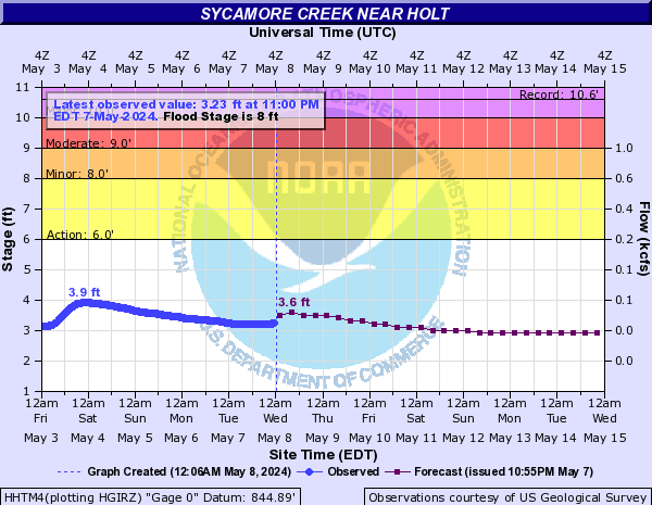
River Levels
The blue curve on the left half of the chart is the measured river level over the past several days. The purple curve on the right half of the chart is the forecast river level over the next week. Click on a chart for additional information. Click here for current information about river levels around the area.
 |
 |
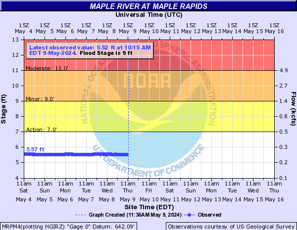 |
| Sycamore Creek near Holt. Trend: Falling. | Grand River at Ionia. Trend: Falling. | Maple River at Maple Rapids. Trend: Cresting. |
Spotter Training Schedule:
Spotter Classes start promptly at the time listed below. Classes are free and open to the public. Classes that require registration due to limited space are listed below. If ‘Registration Required’ is not listed below, there is no registration for the class offering.
Any questions, please email us at: w-grr.webmaster@noaa.gov
|
Date |
Time |
Location |
Sponsor |
|
Saturday, March 5, 2016 |
10:00am - 12:00pm |
Lakeview Middle School 300 South 28th Street Battle Creek, MI |
Calhoun County and the City of Battle Creek |
|
Saturday, March 5, 2016 |
2:00pm - 4:00pm |
Jackson County Jail 1995 Chanter Road Jackson, MI |
Jackson County |
|
Saturday, March 12, 2016 |
10:00am - 12:00pm |
Luella Collins Community Center 419 126th Street Shelbyville, MI 49344 |
Barry County and Allegan County |
|
Saturday, March 12, 2016 |
2:00pm - 4:00pm |
Van Buren Technology Center North/South Dining Room 250 South Street Lawrence, MI 49064 |
Van Buren County |
|
Saturday, March 19, 2016 |
10:00am-12:00pm |
Oceana County Medical Care Facility Upstairs Conference Room 701 East Main Street Hart, MI 49420 |
Oceana County and Mason County |
|
Saturday, March 19, 2016 |
2:00pm - 4:00pm |
Muskegon Community College Stevenson Center 221 South Quarterline Road Muskegon, MI 49442 |
Muskegon County |
|
Wednesday, March 23, 2016 |
6:00pm - 8:00pm |
Regional Center for Agri-Science and Career Advancement - Room 118 5479 West 72nd Street Fremont, MI |
Newaygo County |
|
Saturday, April 16, 2016 |
2:00pm - 4:00pm |
2424 Washington Road Lansing, MI 48911 |
Ingham County |
|
Saturday, April 23, 2016 |
10:00am - 12:00pm |
Clare County Transportation Cabinet 1473 Transportation Drive Harrison, MI 48625 |
Clare County |
|
Saturday, April 23, 2016 |
2:00pm - 4:00pm |
Central Michigan University Brooks Hall - Room 176 |
Isabella County and Central Michigan University |
|
Saturday, April 30, 2016 |
10:00am - 12:00pm |
Alma College Swanson Academic Center 614 Superior Street Alma, MI |
Gratiot County |
 |
Media use of NWS Web News Stories is encouraged! |
|


