Republican River Flood of May 30, 1935
This website is dedicated to preserving the history of the Republican River Flood of 1935.
 |
 |
|
The National Weather Service in Goodland, Kansas has located several of the high water marks that were made and placed in 1936 by Cambridge monument maker, D. F. Neiswanger. Mr. Neiswanger wanted future generations to remember and have proof of how high the water got during the 1935 flood.
 |
 |
|
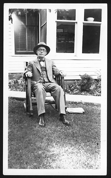
D. F. Neiswanger
Photo courtesy of the Nebraska State Historical Society
|
Photo of a marker created by Mr. Neiswanger.
Photo courtesy of the Nebraska State Historical Society
|
An article was featured in the local newspapers about the trip the National Weather Service staff took to locate most of these markers. The article can be found here. Below are photos and locations where his markers were found, as well as other high water marks from the 1935 flood.
|
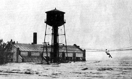
St Francis, Kansas - Power Plant
Latitude: 39.771 ; Longitude: -101.81031
|

|
To the left are recent images of the Power Plant in St. Francis. The white paint and disk mark where the water level was during the 1935 flood. Below are photos during the flood shown during the peak of flooding and then when the water was receding.
|
|

|

|
|

|

|
Haigler, Nebraska
Latitude: 40.01853 ; Longitude: -101.93951
|

|
"Only six of the markers placed by Mr. Neiswanger have been found, whether there are others is uncertain. The first of most westerly is north of Haigler and was point out by Mr. Francis Neville. Go north on the town's main street cross the railroad and continuing to the river bridge. The marker is 200 yards south from the bridge on the east side of the road immediately adjacent to the northwest corner of an old brick building." from High Water Mark by Raymond Borchers.
|
|

|
.jpg)
|
Trenton, Nebraska - Private Property
Latitude: 40.16151 ; Longitude: -101.0129
|

|
"The second is south of the river at Trenton and was pointed out by Mr. Art Carmondy. Go directly south following the town's main street to the dead of the "T" in the road. Walk south about 100 feet beyond the fence continuing in line with Trenton's main street. The marker is flush with the surface and surrounded by four small steel stakes." from High Water Mark by Raymond Borchers.
|
|

|

|
Indianola, Nebraska
Latitude: 40.2327 ; Longitude: -100.4172
|
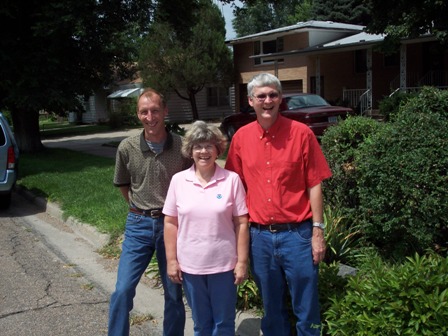
Bill Baumbach is pictured at right with the marker he replaced in its original location in Indianola.
|
One day, when Bill Baumbach was working for the City of Indianola, the local farmer’s cooperative called and said they had removed a granite marker from their property. They suggested it be donated to the museum in McCook, Nebraska. Bill immediately replied that the marker was the property of the City of Indianola, and drove over and picked up the marker which was encased in a large amount of concrete. After carefully removing the concrete, the marker was put on display at the City of Indianola offices. A few weeks later Bill heard about the effort to document the 1935 flood markers placed by D. F. Neiswanger all along the Republican River. Bill, who has since retired, went to the local historical society with his plan to restore the marker to its original location along with a sign presented to the city by the National Weather Service. On September 21, Bill reached his goal. With the help of the City of Indianola the marker, pictured on the left, was restored to its original location! |
Bartley, Nebraska
Latitude: 40.24972 ; Longitude: -100.30621
|

|

|
|
.jpg)
|
"The third is in Bartley at the corner of Commercial (main north-south street) and Cedar (one block south of Highway 6-34) on the northwest corner of the intersection mounted on a small pedestal. Its location was described by Mrs. Betty Arrington." from High Water Mark by Raymond Borchers.
|
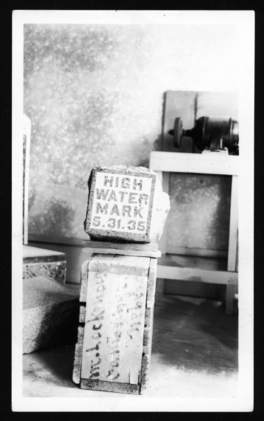
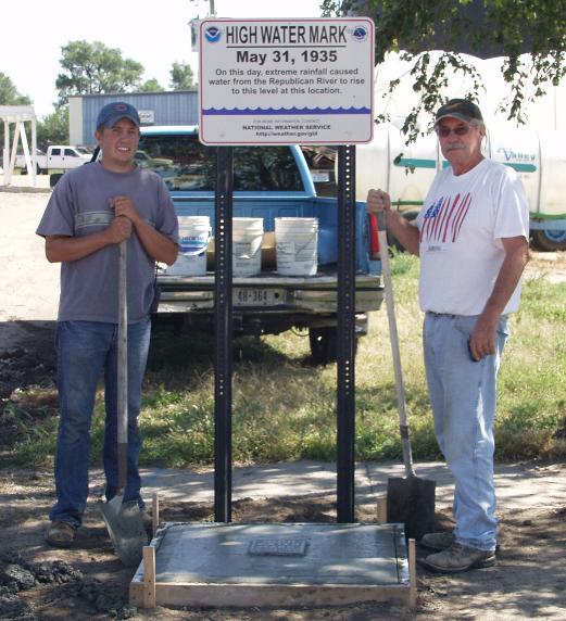
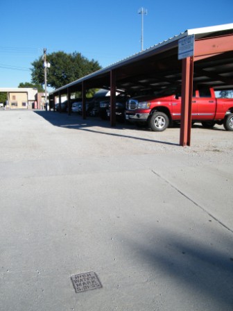
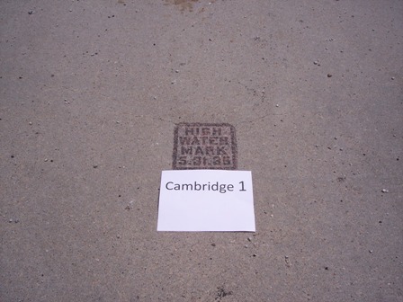
Cambridge, Nebraska #1
Latitude: 40.28175 ; Longitude: -100.16599
|
|
"There are two markers in Cambridge both pointed out by Mr. R.L. Bible. The forth, the first placed, is west of the now razed Cambridge Lumber Company at the corner of Nasby (Highway 6-34) and Patterson (Highway 47 or main street). The marker is 20 feet south of the southeast corner of in the section, flush with the surface and adjacent to the curb." from High Water Mark by Raymond Borchers.
|
|
|
|
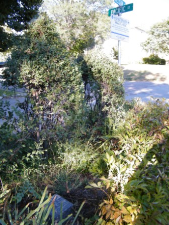
Cambridge, Nebraska #2 - Private Property
Latitude: 40.28308 ; Longitude: -100.17060
|

|

|
|
|
"The first of at the corner of Pacific (three blocks west of Patterson) and Nelson (one block north of Highway 6-34). It is mounted flush on the northwest corner of the intersection." from High Water Mark by Raymond Borchers.
|
Edison, Nebraska
Latitude: 40.27742 ; Longitude: -99.7763
|

|
"The sixth is in a small city park in Edison mounted on a pedestal three feet high. The marker is 100 feet north from the northeast corner of the intersection of the main north-south street and old Highway 6 (east-west). Present Highway 136 makes a right angle turn at this intersection." from High Water Mark by Raymond Borchers.
|
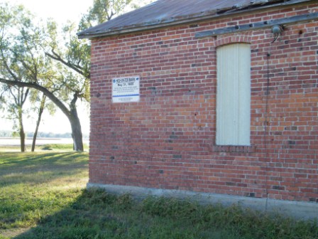
Mill Farm at Arapahoe, Nebraska
Latitude: 40.2889 ; Longitude: -99.8978
|
|
A portion of the city light plant still stands on the property of Doug and Cheryl Schutz.
The building is located south of Arapahoe on Highway 283, and while on private property, is easily visible from the road.
|
|

|
There are obvious water marks on the bricks, and a mark on the door showing the height of the water during the 1935 Republican River flood. |
Nebraska Historical Marker - Oxford, NE Click here for text
The marker is located on U.S. 136, 1.2 miles west of Oxford

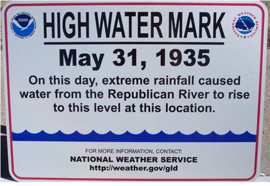
Alma, Nebraska
Location: Latitude 40.09566 Longitude 99.36348
|
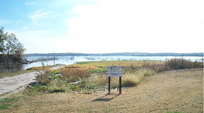
The High Water Mark sign was placed near the boat dock at Harlan County Lake which was built after the flood of 1935.
|
If any other high water markers are around that we do not have listed here, we would like to know about them. Please visit the Contact Us tab.
|


