A number of severe weather events hit Siouxland in 2001, mainly from three severe thunderstorms and several winter storms. At the Sioux Gateway airport, where official observations are taken for Sioux City, a total of 30.53 inches precipitation was recorded for 2001, or 4.67 inches above normal. The average temperature for 2001 was 48.8 degrees, or near the normal of 48.5 degrees.
The winter season from 2000-2001 was colder and snowier than normal with several icy winter storms in the area. Average temperature for the meteorological winter months of December, January, and February was 16.3 degrees, or the 9th coldest such winter period on record. Total snowfall for the season from November through April was 48.0 inches, compared to an average of 31.8 inches. Significant snowfalls reported for 2001 at the airport were 4.7 inches on January 13th, 4.7 inches on January 29th, 3.0 inches on February 7-8th, and 3.8 inches on February 14th. Winter storms that had both freezing rain and snow were reported on January 29th, February 24-25th , and March 11-12th. All of these storms caused treacherous or difficult travel in the area. The lowest temperature of 2001 was recorded on February 2nd with 16 degrees below zero.
April to June was overall stormy and wet with near normal temperatures. The following were significant spring and summer weather events in the Sioux City area...
April 7th...Strong southwest winds gusted as high as 64 mph at Sioux City in the early morning hours, first due to thunderstorm gusts from 210-225 AM, and then due to a strong wind gradient from 430-830 AM. These winds caused roof damage to numerous businesses and homes, along with sign and tree damage in the area.
April 10-11th...1.90 inches rain occurred at the airport within 24 hours.
April 20th...Heavy rain caused urban and basement flooding late in the evening in Sioux City, but only .43 inch precipitation occurred at the airport south of the city.
April 30th...Hail up to the size of half-dollars was associated with thunderstorms in the late afternoon.
May 4-5th...1.44 inches of rain occurred within 24 hours. A total of 3.72 inches rainfall was registered at the airport in the first 6 days of May.
May 14-15th...A record high temperature of 97 degrees occurred on the 14th. On the 15th the high temperature was 101 degrees which was the warmest temperature of 2001, and also the warmest on record for so early in the season. The old record for the 15th was 94 degrees set back in 1894.
June 13th...Big thunderstorms in the early evening brought wind gusts to 67 mph and nickel size hail to Sioux City along with 1.20 inches rain at the airport.
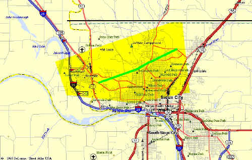 August 2nd...Between 740 and 800 AM in the morning, thunderstorm downburst winds caused extensive tree damage in Sioux City. Large trees were uprooted, snapped, and stripped. A few vehicles were completely destroyed by the falling trees. Houses and other buildings, including a nursing home, were also damaged by trees and debris. Many streets were blocked. Power lines and poles were also blown down, resulting in power outages affecting at least 40,000 people. Traffic lights were blown down. Roofs were damaged, including the roof blown off a medical office building, and sheet metal ducting off a road. A 95 foot radio tower was also blown down, damaging a car and small building. This image shows the approximate damage location in Sioux City. Click the image to enlarge.
August 14-15th...1.93 inches rain was measured for the greatest 24 hour precipitation amount in 2001.
August 17th...In Jackson, Nebraska west of Sioux City in the late afternoon, a tornado completely destroyed at least 10 houses and heavily damaged several others. The tornado heavily damaged the town school, including taking most of the roof off the school. The only church in town and a telephone company building were also heavily damaged. Power lines, poles, and trees were blown down, and electricity and water service were knocked out. Three empty box cars on the southeast side of Jackson were toppled. Three injuries included a woman with a broken leg and cuts rescued from the rubble of a house, and two children with minor injuries.
September 13-14th...1.63 inches rain occurred within 24 hours.
The rest of the year was rather uneventful in Sioux City. A record low of 30 degrees was tied on September 24th. November was interesting as it was the warmest November on record, and 1.83 inches rain fell during the 23rd-24th. Record highs were set on November 12th, 15th, and 16th with 69, 75, and 75 degrees, respectively. December also averaged well above normal in temperature for the month, but temperatures finally dipped to seasonal levels in the last week of the year.
THE FOLLOWING TABLES GIVE A MONTH BY MONTH BREAKDOWN OF WEATHER IN 2001 AT THE SIOUX CITY AIRPORT...
AVERAGE             DEPARTURE  EXTREMES    MONTHLY
 MONTH          MAX   MIN   MONTHLY  FROM NORM  HIGH LOW    RECORDS

JANUARY        31.0  12.7     21.9    PLUS 4.2   48  11B
FEBRUARY       24.7   6.4     15.6   MINUS 8.0   39  16B
MARCH          38.7  22.8     30.8   MINUS 5.0   60  10
APRIL          65.1  38.1     51.6    PLUS 1.4   87  23
MAY            72.9  50.3     61.6        ZERO  101  42
JUNE           82.5  58.3     70.4   MINUS 0.4   97  47
JULY           85.9  65.7     75.8    PLUS 0.1   95  54
AUGUST         83.3  59.9     71.6   MINUS 1.2   94  48
SEPTEMBER      73.4  49.2     61.3   MINUS 2.1   86  30
OCTOBER        63.8  37.1     50.5   MINUS 1.3   90  16
NOVEMBER       59.9  33.0     46.5   PLUS 10.1   77  18  1ST WARMEST
DECEMBER       39.3  17.8     28.6    PLUS 6.8   62   3B

 2001          60.0  37.6     48.8    PLUS 0.3  101  16B

NORMAL YEAR    59.2  37.7     48.5
DEPARTURE             DEPARTURE    MAX WIND GUSTS...
   MONTH           FROM NORM   SNOWFALL  FROM NORM   DIRECTION/MPH/DATE

JANUARY    1.72    PLUS 1.17     12.2     PLUS 5.8      NW 46 ON 26TH
FEBRUARY    .61   MINUS  .10      7.3     PLUS 1.6      NW 45 ON 25TH
MARCH       .87   MINUS 1.09      2.2    MINUS 5.3      NW 43 ON 13TH
APRIL      5.21    PLUS 2.87      0.2    MINUS 1.1      SW 64 ON 7TH
MAY        5.87    PLUS 2.20       0                    NW 41 ON 23RD
JUNE       2.57   MINUS 1.14       0                     W 67 ON 13TH
JULY       2.18   MINUS 1.09       0                    NW 46 ON 21ST
AUGUST     3.40    PLUS  .43       0                    NW 63 ON 2ND
SEPTEMBER  3.39    PLUS  .51       0                    NW 33 ON 7TH
OCTOBER    1.21   MINUS  .73       0     MINUS 0.9      NW 51 ON 25TH
NOVEMBER   3.05    PLUS 1.97       T     MINUS 3.3      NW 44 ON 7TH
DECEMBER    .45   MINUS  .33      3.5    MINUS 3.2      NW 46 ON 23RD

 2001     30.53    PLUS 4.67     25.4    MINUS 6.4       W 67 ON JUN 13TH


RICHARD S. RYRHOLM...CLIMATIC FOCAL POINT


 Weather Story
 Weather Map
 Local Radar