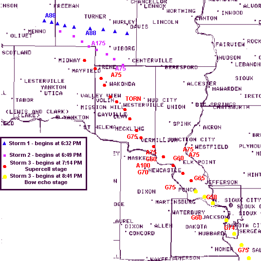
The total precipitation at Sioux City Airport in 2000 was 23.81 inches which was 2.05 inches below normal. There were the usual variations in the precipitation over the area...mainly due to the localized nature of summertime thunderstorms. The temperature for the year averaged out to 48.7 degrees...only 0.2 degree above normal.
 The first part of the year 2000 generally continued the warm and dry weather pattern that started in September 1999. Temperatures averaged about 7 degrees above normal from November 1999 through March of 2000...with a total seasonal snowfall of 17.1 inches compared to a normal of 31.8 inches. There were a number of mild windy days with low humidity helping cause grass and vegetation fires in the area in the first four months. The worst of the conditions was on April 5th when northwest winds gusted to 54 mph at the Sioux City airport.
The weather pattern fortunately changed to wetter and cooler compared to normal from April through July. A number of heavy or severe storms moved through the area during the period...including the following:
May 18th...Just after midnight thunderstorms caused 1.27 inches rainfall and winds as high as 48 mph.
May 25-26th...Rain brought 1.40 inches precipitation.
 June 3rd...The strongest wind of the year of 74 mph occurred at the Sioux City airport at 910 pm associated with a severe thunderstorm that caused damage from Salix to 3 miles northeast of Sloan.
June 13th...Thunderstorms rolled through Sioux City between 245 and 300 pm with wind gusts up to 60 mph causing some tree damage...and very heavy rain causing street flooding.
June 25th...Thunderstorms around midday brought the biggest rain event of the year with 2.33 inches registering at the airport.
July 24th...Around 11 pm thunderstorms dropped .80 inch of rain at the airport and caused wind gusts up to 60 mph in the area.
August to October returned to a relatively dry and warm spell overall. The temperature reached 101 degrees on August 30th tying a record high for the date. On September 2nd the mercury soared to 103 degrees...a new record for that date...and the warmest temperature since 1995. However...there was a record cold spell from October 6th to the 10th when a unusually cold polar high pressure system moved slowly southeast over the area and put an end to the growing season. Record low temperatures were broken or tied for 5 days in a row from the 6th through the 10th at the airport...reaching a low for the month of 17 on October 8th. Also on October 8th a record high barometric pressure for October was set with 30.83 inches of mercury.
A more substantial return to a wetter and colder pattern started with a welcome 1.19 inches of rain on October 29th. Then the bottom fell out on the temperatures in November and December. November 2000 was the 3rd coldest November on record...averaging 9.2 degrees below normal. December 2000 was the 2nd coldest December on record...averaging 10.3 degrees below normal for the month. The biggest snowfall of the year of 6.4 inches snowfall occurred from December 10-11th. There were a couple of blizzards in December with the worst on December 16th when the northwest winds gusted to 58 mph and wind chills dropped to 55 below zero.
THE FOLLOWING TABLES GIVE A MONTH BY MONTH BREAKDOWN OF WEATHER IN 2000 AT THE SIOUX CITY AIRPORT...
AVERAGE             DEPARTURE  EXTREMES    MONTHLY
 MONTH          MAX   MIN   MONTHLY  FROM NORM  HIGH LOW    RECORDS

JANUARY        33.1  11.1     22.1    PLUS 4.4   54   4B
FEBRUARY       44.9  22.1     33.5    PLUS 9.9   71   5
MARCH          55.7  29.0     42.4    PLUS 6.6   77  14
APRIL          64.4  37.2     50.8    PLUS 0.6   83  19
MAY            77.7  51.0     64.4    PLUS 2.8   92  38
JUNE           80.6  55.8     68.2   MINUS 2.6   99  45
JULY           83.3  63.9     73.6   MINUS 2.1   92  48
AUGUST         85.0  62.7     73.9    PLUS 1.1  101  53
SEPTEMBER      80.3  48.5     64.4    PLUS 1.0  103  30
OCTOBER        65.7  40.4     53.1    PLUS 1.3   89  17
NOVEMBER       34.9  19.4     27.2   MINUS 9.2   69   1    3RD COLDEST
DECEMBER       19.7   3.2     11.5  MINUS 10.3   43  16B   2ND COLDEST

 2000          60.4  37.0     48.7    PLUS 0.2  103  16B

NORMAL YEAR    59.2  37.7     48.5
DEPARTURE             DEPARTURE     MAX WIND GUSTS...
   MONTH           FROM NORM   SNOWFALL  FROM NORM    DIRECTION/MPH/DATE

JANUARY     .40   MINUS  .15      4.1    MINUS 2.3      NW 53 ON 10TH
FEBRUARY    .76    PLUS  .05      4.0    MINUS 1.7       S 49 ON 25TH
MARCH       .71   MINUS 1.25      1.0    MINUS 6.5      NW 49 ON 26TH
APRIL      1.87   MINUS  .47      1.9     PLUS 0.6      NW 54 ON 5TH
MAY        3.91    PLUS  .24       0                    SW 55 ON 30TH
JUNE       5.66    PLUS 1.95       0                    NW 74 ON 3RD
JULY       3.14   MINUS  .13       0                    SW 48 ON 24TH
AUGUST     1.78   MINUS 1.19       0                     W 43 ON 5TH
SEPTEMBER  1.06   MINUS 1.82       0                    NW 40 ON 20TH
OCTOBER    2.23    PLUS  .29       0     MINUS 0.9       S 38 ON 19TH
NOVEMBER   1.55    PLUS  .47      8.3     PLUS 5.0      NW 45 ON 29TH
DECEMBER    .69   MINUS  .09     18.0    PLUS 11.3      NW 58 ON 16TH

 2000     23.81   MINUS 2.05     37.3     PLUS 5.5      NW 74 JUNE 3RD

RICHARD S. RYRHOLM...CLIMATIC FOCAL POINT