On the evening of August 27, a large thunderstorm complex moved across the Sioux Falls area causing significant flooding on the south side of Sioux Falls. As is typical with thunderstorms, rainfall across the city varied significantly depending upon where one was located. On the southwest side of Sioux Falls 6 to 8 inches of rain was reported. On the southeast side of Sioux Falls, rainfall was generally 3 to 5 inches. And as one move north of the city rainfall decreased rapidly with 2.61 inches at the aiport and only 0.62 inches of rain 4 miles north of Renne. The storm also weakened as it moved east of Sioux Falls and as a result around 2 inches of rain fell around Brandon and Garretson.
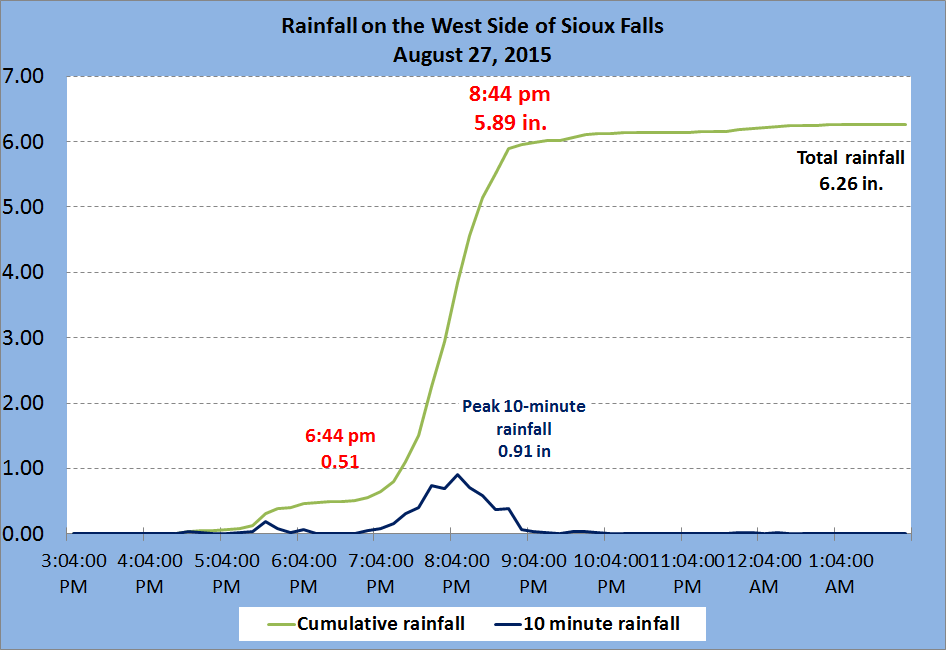
Below is a map showing how rainfall varied across the city followed by a table showing the approximate location of each report. Lastly, we have a graph which shows how quickly the rainfall fell during the evening for August 27 on the west side of Sioux Falls. In a ten minute period, 0.91 inches of rain fell and 5.38 inches of rain accumulated in 2 hours! It both the amount of rain and the intensity of the rain that caused the significant flooding over the south side of Sioux Falls.

| Location | 24-h Rainfall (in.) |
| Siou xFalls 3.9 SW | 7.52 |
| Sioux Falls 3.4 WSW | 7.26 |
| Tea 4 NNE | 6.93 |
| Sioux Falls 3.7 WSW | 6.83 |
| Sioux Falls 4.2 WSW | 6.70 |
| Sioux Falls 1.9 SSW | 6.34 |
| Sioux Falls 4 W | 6.31 |
| Sioux Falls 4.5 S | 6.16 |
| Sioux Falls 4.1 SSE | 5.30 |
| Sioux Falls 3 W | 4.81 |
| Sioux Falls 3 SSW | 4.71 |
| Sioux Falls 5.2 SE | 4.71 |
| Sioux Falls 4.5 SSW | 4.20 |
| Sioux Falls 4 S | 4.15 |
| Sioux Falls 3.4 ESE | 3.84 |
| Sioux Falls 5.0 SE | 3.82 |
| Harrisburg 2.5 NW | 3.81 |
| Sioux Falls 3.6 ESE | 3.45 |
| Sioux Falls Airport | 2.61 |
| Sioux Falls 5.2 E | 2.55 |
| Brandon 4.0 SE | 2.38 |
| Brandon 1 NNE | 2.30 |
| Hartford 6.4 S | 2.27 |
| Garretson 4.2 SSE | 1.90 |
| Lennox 3.3 NE | 1.73 |
| Garretson 6.9 W | 0.64 |
| Renner 4.1 NW | 0.62 |
| Hartford 2 ENE | 0.34 |


 Weather Story
 Weather Map
 Local Radar