Overview
|
A potent spring storm system moved through the Central Plains on Wednesday March 19th, 2025. After initial light rain showers, a heavy band of snow developed across eastern Nebraska and western Iowa with 7-10+ inches of snow or more near Ida Grove, Storm Lake, and locations southeastward. On the northwest side of the band, there was a sharp cutoff in snowfall with Spirit Lake, Orange City, and Newcastle receiving an inch or less of snow. This heavy snowfall, coupled with widespread northwest winds gusting 40 to 65 mph, resulted in blizzard conditions for much of Wednesday across northwest Iowa while snow was falling. Travel was not advised in the blizzard area with numerous power outages and school closures. I-29 was closed from the South Dakota border (North Sioux City) to Missouri Valley, IA, and it took through the following day for roads to be opened and power to be restored. |
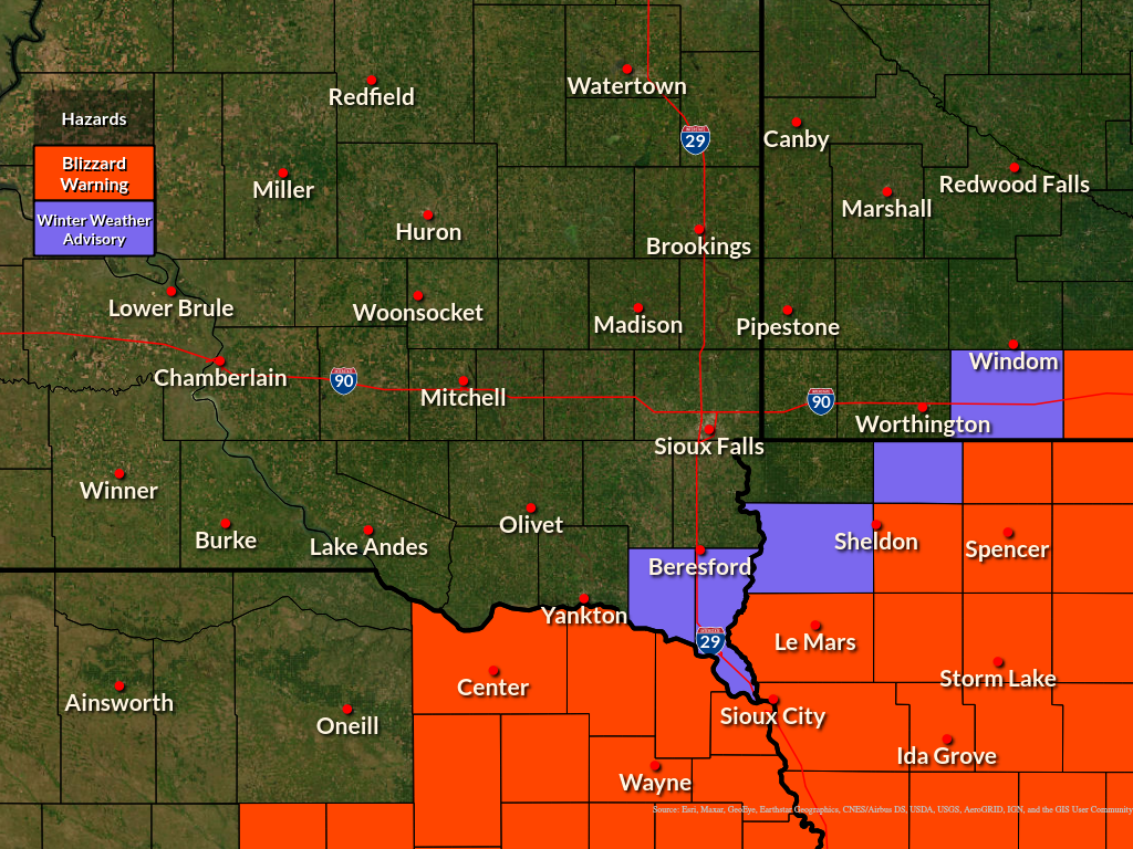 Winter Weather Headlines on March 19th, 2025 |
Wind
Northwest winds increased Tuesday night with gusts exceeding 40 mph common on Wednesday. Peak gusts were 45 to 65 mph, causing whiteout conditions while snow was falling.
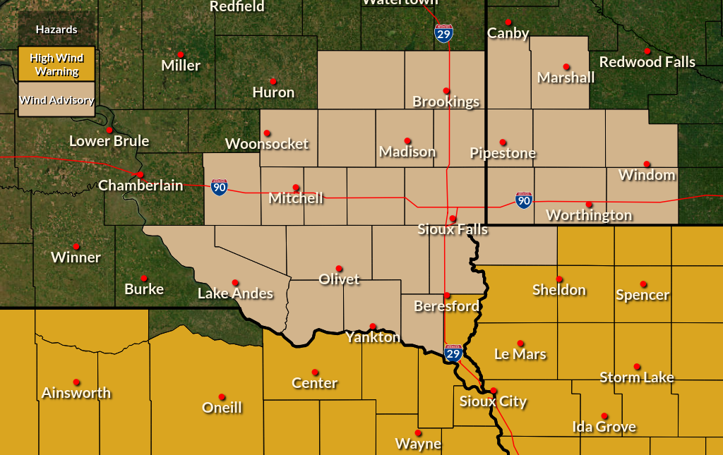 |
| Wind Advisory and High Wind Warning for Wednesday 03/19/2025 |
...HIGHEST WIND REPORTS FROM MARCH 19 2025 ...

Location                     Speed     Time/Date       Provider

...Iowa...

...Buena Vista County...
Storm Lake Airport           63 MPH    0115 PM 03/19   AWOS
Storm Lake                   46 MPH    1110 AM 03/19   MESOWEST

...Clay County...
Webb                         61 MPH    1115 AM 03/19   Mesonet
Spencer Municipal Airport    56 MPH    1144 AM 03/19   ASOS

...Dickinson County...
Lake Park                    59 MPH    0235 PM 03/19   Mesonet
1 NNE Wahpeton               58 MPH    0854 AM 03/19   Mesonet

...OBrien County...
Sheldon Airport              49 MPH    0915 AM 03/19   AWOS

...Osceola County...
MAY CITY                     49 MPH    0850 AM 03/19   CWOP
Sibley                       48 MPH    0755 AM 03/19   MESOWEST

...Plymouth County...
Le Mars Airport              47 MPH    0835 AM 03/19   AWOS
Loess Hills Tnc Broken       45 MPH    0411 AM 03/19   RAWS

...Sioux County...
1 NE Maurice                 52 MPH    0915 AM 03/19   AWOS
Alton                        49 MPH    0245 PM 03/19   MESOWEST
Hawarden                     46 MPH    0930 AM 03/19   CWOP

...Woodbury County...
Sioux Gateway Airport        55 MPH    1113 AM 03/19   ASOS
Sioux City                   47 MPH    0225 AM 03/19   CWOP

...Minnesota...

...Cottonwood County...
T.h.60 - Mountain Lake - Mp  47 MPH    0140 PM 03/19   MESOWEST

...Jackson County...
I-90 - Lakefield - Mp 67     46 MPH    1255 PM 03/19   MESOWEST
Jackson Airport              45 MPH    0335 PM 03/19   AWOS

...Lincoln County...
U.s.14 - Lake Benton - Mp 7  50 MPH    0845 AM 03/19   MESOWEST
T.h.19 - Hendricks - Mp 2    48 MPH    0810 AM 03/19   MESOWEST

...Lyon County...
U.s.14 - Florence - Mp 21.2  56 MPH    1110 AM 03/19   MESOWEST

...Murray County...
T.h.30 - Dovray - Mp 49      48 MPH    0405 PM 03/19   MESOWEST

...Nobles County...
I-90 - Rushmore - Mp 35      54 MPH    1040 AM 03/19   MESOWEST
Worthington Airport          46 MPH    1108 AM 03/19   AWOS

...Pipestone County...
U.s.75 - Trosky - Mp 30.3    54 MPH    1000 AM 03/19   MESOWEST

...Rock County...
I-90 - Beaver Creek Mp 4     57 MPH    0940 AM 03/19   MESOWEST
I-90 - Magnolia - Mp 21.6    50 MPH    0945 AM 03/19   MESOWEST

...Nebraska...

...Dixon County...
2 WNW Ponca                  59 MPH    0235 PM 03/19   Trained Spotter
Concord 2E                   45 MPH    1205 PM 03/19   NE-MESO

...South Dakota...

...Aurora County...
SD RWIS Plankinton           54 MPH    0929 AM 03/19   SDDOT

...Beadle County...
Huron Regional Airport       48 MPH    1255 PM 03/19   ASOS

...Bon Homme County...
SD RWIS Tyndall              50 MPH    1100 AM 03/19   SDDOT

...Brule County...
SD RWIS Kimball              46 MPH    1214 PM 03/19   SDDOT

...Charles Mix County...
SD RWIS WAGNER               50 MPH    0844 AM 03/19   SDDOT
SD RWIS Platte-Winner Bridge 50 MPH    1150 AM 03/19   SDDOT
Lake Andes RAWS              49 MPH    0241 AM 03/19   RAWS

...Clay County...
Beresford 7 WSW (SD Mesonet) 52 MPH    0700 AM 03/19   SDSMESO

...Davison County...
Mount Vernon                 50 MPH    0815 AM 03/19   SDSMESO
Mitchell Municipal Airport   48 MPH    1050 AM 03/19   ASOS

...Douglas County...
SD RWIS Corsica              53 MPH    0829 AM 03/19   SDDOT

...Gregory County...
SD RWIS Ft. Randall Dam      53 MPH    0900 AM 03/19   SDDOT
Gregory 16N                  49 MPH    1250 PM 03/19   SDSMESO
SD RWIS Dixon                47 MPH    0130 PM 03/19   SDDOT
SD RWIS Dallas               46 MPH    0333 PM 03/19   SDDOT

...Hanson County...
SD RWIS Alexandria           51 MPH    1209 PM 03/19   SDDOT

...Hutchinson County...
SD RWIS Tripp                52 MPH    1119 AM 03/19   SDDOT
Menno 7ESE                   50 MPH    0210 PM 03/19   SDSMESO
SD RWIS Freeman              47 MPH    0615 AM 03/19   SDDOT

...Jerauld County...
SD RWIS Lane                 47 MPH    0734 AM 03/19   SDDOT

...Lincoln County...
SD RWIS Davis                53 MPH    0634 AM 03/19   SDDOT

...McCook County...
SD RWIS Montrose             50 MPH    0924 AM 03/19   SDDOT
SD RWIS STANLEY CORNER       48 MPH    0424 PM 03/19   SDDOT

...Minnehaha County...
Sioux Falls Airport          47 MPH    0638 AM 03/19   ASOS

...Moody County...
Flandreau 3 NNE (SD Mesonet) 52 MPH    0800 AM 03/19   SDSMESO
SD RWIS Ward                 49 MPH    0358 PM 03/19   SDDOT

...Sanborn County...
SD RWIS Forestburg           46 MPH    0915 AM 03/19   SDDOT
Woonsocket 4NNW              45 MPH    0645 AM 03/19   SDSMESO

...Turner County...
SD RWIS IRENE                49 MPH    0603 AM 03/19   SDDOT
SD RWIS Parker               49 MPH    1222 PM 03/19   SDDOT
Parker 7NNE                  46 MPH    0755 AM 03/19   SDSMESO

...Union County...
SD RWIS North Sioux City     57 MPH    0539 AM 03/19   SDDOT
SD RWIS Beresford            50 MPH    0726 AM 03/19   SDDOT

...Yankton County...
SD RWIS Gayville             53 MPH    0559 AM 03/19   SDDOT
Yankton Municipal Airport    45 MPH    1244 PM 03/19   AWOS

Observations are collected from a variety of sources with varying
equipment and exposures. We thank all volunteer weather observers
for their dedication. Not all data listed are considered official.
Snow/Ice
Wet, heavy snow fell in a band across portions of eastern Nebraska and western Iowa on Wednesday with a sharp cutoff on the north side.
 |
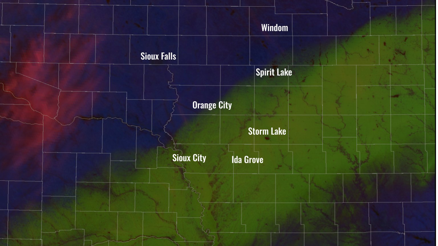 |
| Map of storm total snowfall reports from March 19th, 2025 shows a sharp cutoff on the north side of the snow band. | GOES East satellite image from March 20th, 2025 shows a swath of heavy snow (green) near and south of a Sioux City to Spirit Lake line, with bare ground (blue) further north. |
...SNOWFALL REPORTS FOR MARCH 19TH, 2025...

Location                     Amount    Time/Date       Provider

...Iowa...

...Buena Vista County...
Sioux Rapids                 8.0 in    0700 AM 03/20   CO-OP Observer

...Cherokee County...
0.9 NE Cherokee              6.0 in    0800 AM 03/20   COOP
Cherokee 4.5 NNW             5.2 in    0700 AM 03/20   COCORAHS

...Clay County...
1 N Spencer                  2.0 in    0200 PM 03/19   CO-OP Observer

...Dickinson County...
4 NW Okoboji                 1.0 in    1200 AM 03/20   CO-OP Observer
1 W Spirit Lake              1.0 in    0700 AM 03/20   CO-OP Observer
3 SSE Lake Park              0.3 in    0800 AM 03/20   CO-OP Observer

...Ida County...
Holstein 6.8 SSW             8.5 in    0700 AM 03/20   COCORAHS
Battle Creek                 8.0 in    0415 PM 03/19   Public
1 WSW Ida Grove              8.0 in    0415 PM 03/19   Trained Spotter
Holstein                     7.0 in    0100 PM 03/19   Broadcast Media
Arthur 3.7 SSW               7.0 in    0649 AM 03/20   COCORAHS

...OBrien County...
Primghar                     0.5 in    0400 PM 03/19   COOP
Sheldon                       T in     0800 AM 03/20   CO-OP Observer

...Osceola County...
Sibley                        T in     0800 AM 03/20   CO-OP Observer

...Plymouth County...
Le Mars                      3.3 in    0800 AM 03/20   COOP
Remsen                       3.2 in    0330 PM 03/19   COOP

...Sioux County...
Orange City                  0.4 in    0700 AM 03/20   COOP

...Woodbury County...
3.4 N Hornick                6.7 in    0700 AM 03/20   COOP
Sergeant Bluff               5.0 in    0100 PM 03/19   Official NWS Obs

...Minnesota...

...Jackson County...
Jackson                      0.4 in    0613 PM 03/19   Public

...Nobles County...
2 NE Worthington             0.0 in    0800 AM 03/20   CO-OP Observer

...Nebraska...

...Dixon County...
Concord                      1.2 in    0500 PM 03/19   COOP
Newcastle                    0.0 in    0800 AM 03/20   CO-OP Observer

Observations are collected from a variety of sources with varying
equipment and exposures. We thank all volunteer weather observers
for their dedication. Not all data listed are considered official.
Radar
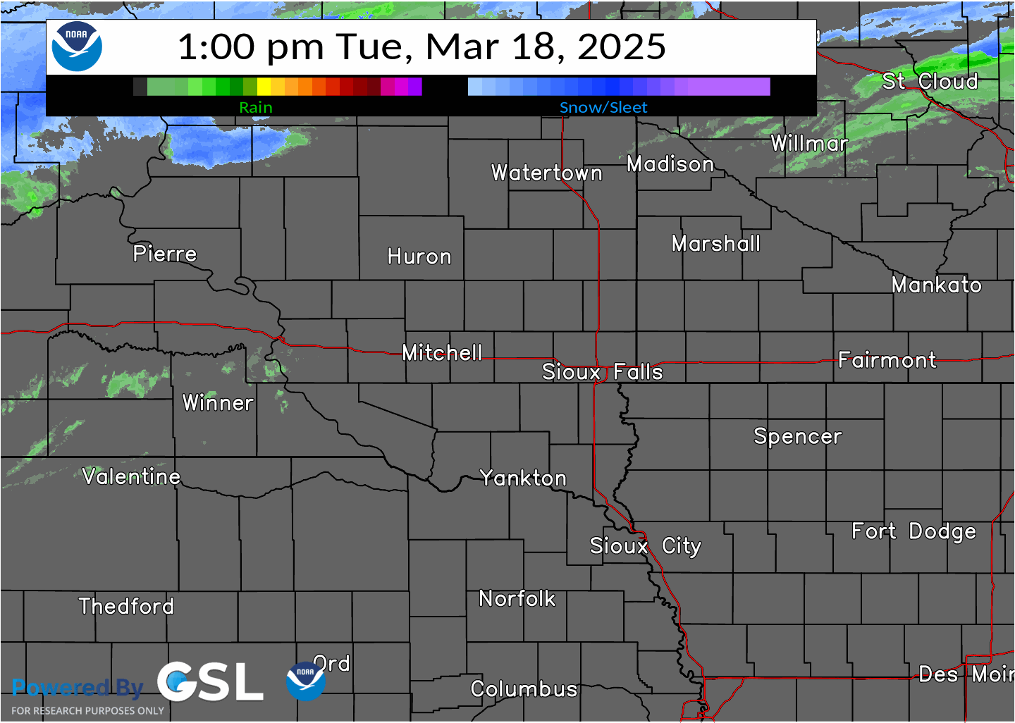
Scattered rain showers transitioned to snow Tuesday evening with a band of wet, heavy snow developing across portions of northeast Nebraska, northwest Iowa, and southern Minnesota Wednesday morning.
 |
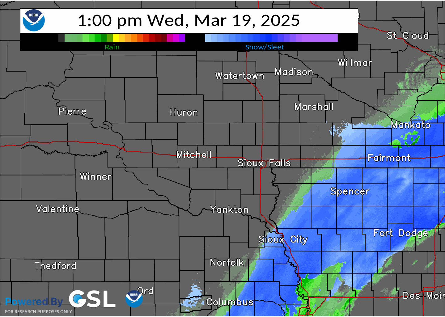 |
| Radar Precipitation Type from 1 PM Tue March 18th to 1 PM Wed March 19th, 2025 | Radar Precipitation Type from 1 PM to 9 PM Wed March 19th, 2025 |
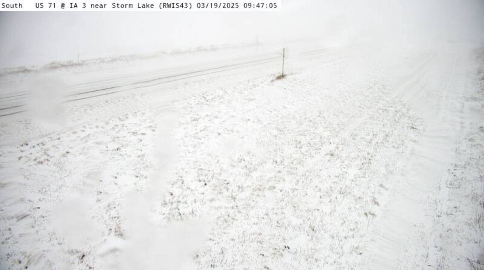
Photos & Video
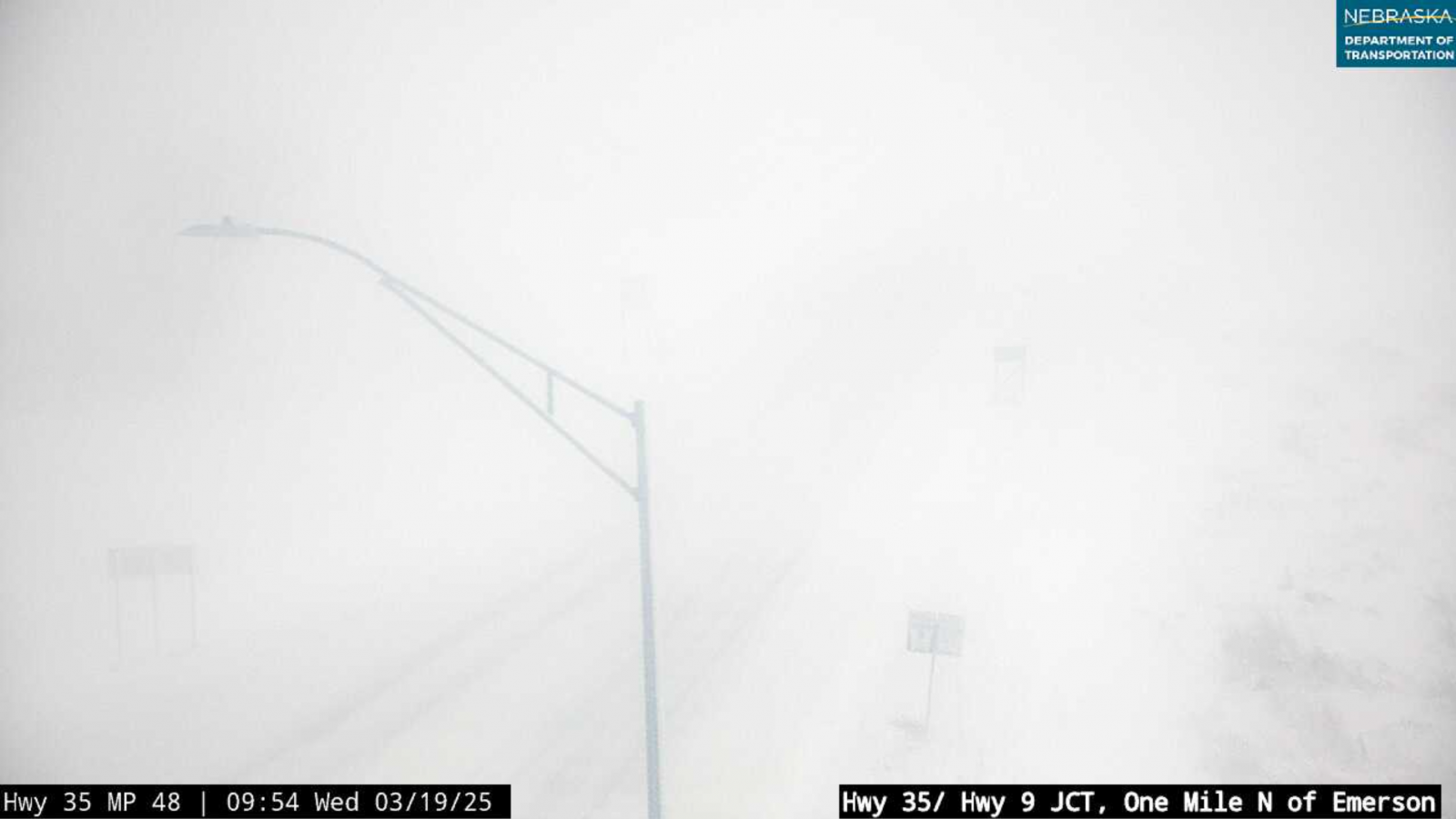
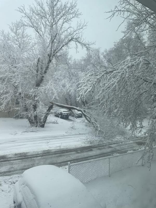
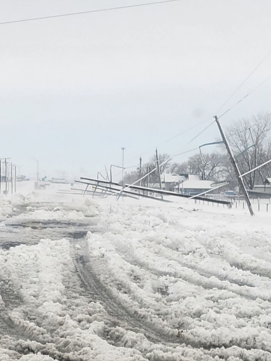
Heavy, wet snow combined with high winds caused whiteout conditions, tree damage, and power outages across much of northwest Iowa on Wednesday March 19th, 2025. Travel was unadvised for much of the area, and many schools and businesses closed.
 |
 |
 |
 |
| Near Whiteout Conditions near Emerson, NE (NE DOT) |
Tree damage in Sioux City, IA (Bethany Jones) |
Power lines down south of Sioux City, IA (Salmen Nelson) |
Near Whiteout Conditions near Storm Lake, IA (IA DOT) |
 |
Media use of NWS Web News Stories is encouraged! Please acknowledge the NWS as the source of any news information accessed from this site. |
|


 Weather Story
 Weather Map
 Local Radar