Overview
|
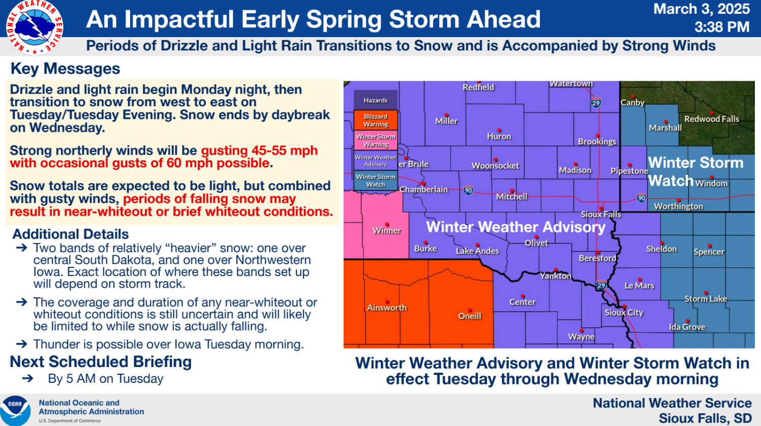
A major winter storm resulted in moderate to major impacts much of the region from the morning of Tuesday March 4th to the afternoon of Wednesday March 5th, 2025. Light rain or drizzle, as well as isolated thunderstorms, transitioned to light to moderate snow during day through early evening of Tuesday March 4th 2025. Snow coupled with very strong winds gusting 40 to 65 mph, producing blizzard conditions along and east of a Minneota, MN to Orange City, IA to Elk Point, SD line on Tuesday night March 4th through Wednesday afternoon March 5th. The greatest impacts occurred where the heaviest snow and strongest winds coincided across northwest Iowa, northeast Nebraska, and portions of southwest Minnesota. Interstate 90 was closed east of Luverne, MN and most roads in southwest Minnesota, northeast Nebraska, and northwest Iowa were either closed, impassable, or with travel not advised by the morning of Wednesday March 5th. |
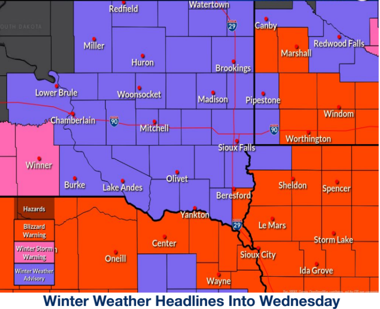 Strong wind gusts and blowing snow brought difficult (Winter Weather Advisory) to impossible (Blizzard Warning) travel to the region |
Wind:
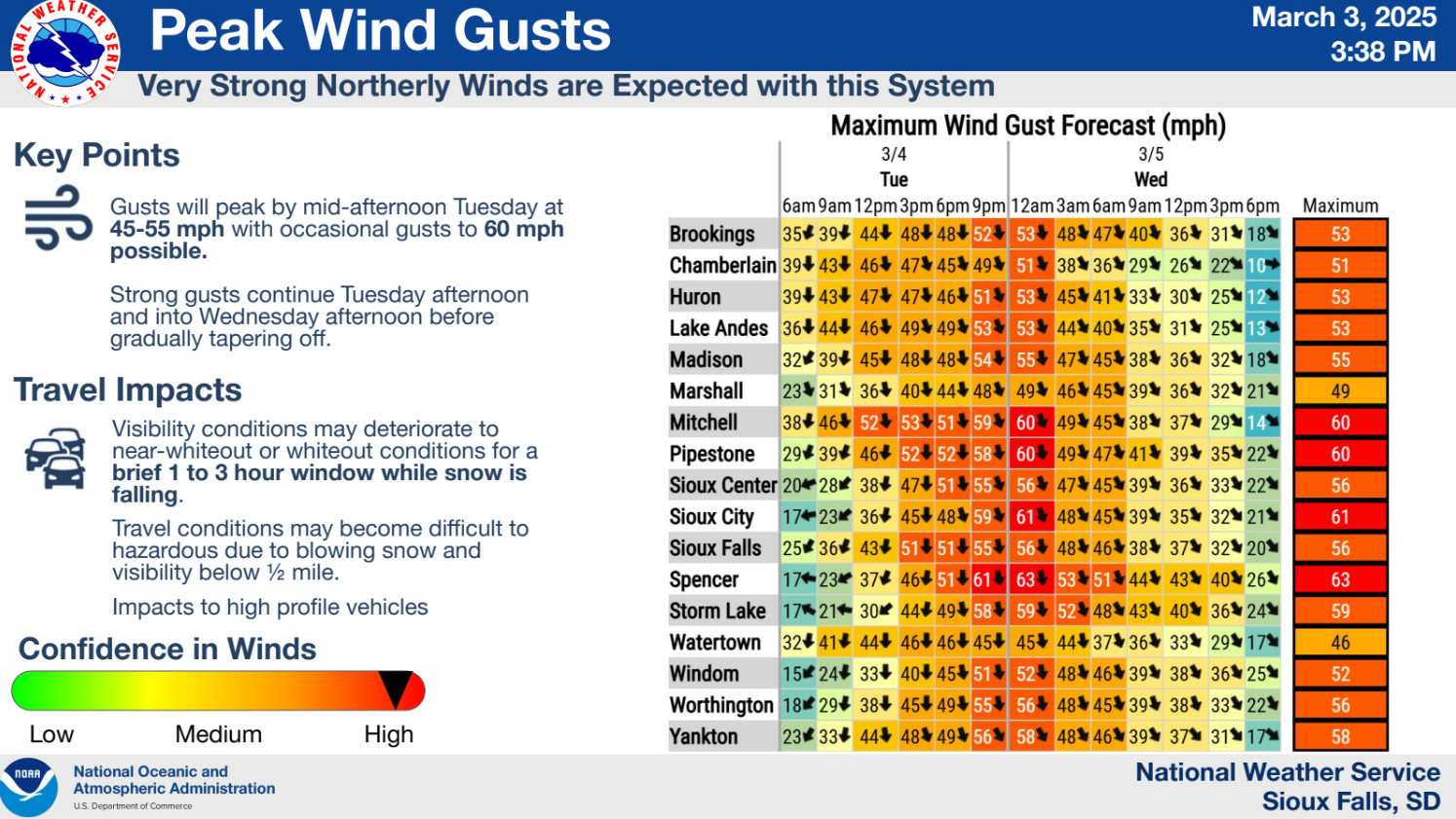
Wind gusts of 40-60 mph were common during the evening on March 4th, continuing overnight, and gradually weakening west to east on March 5th.
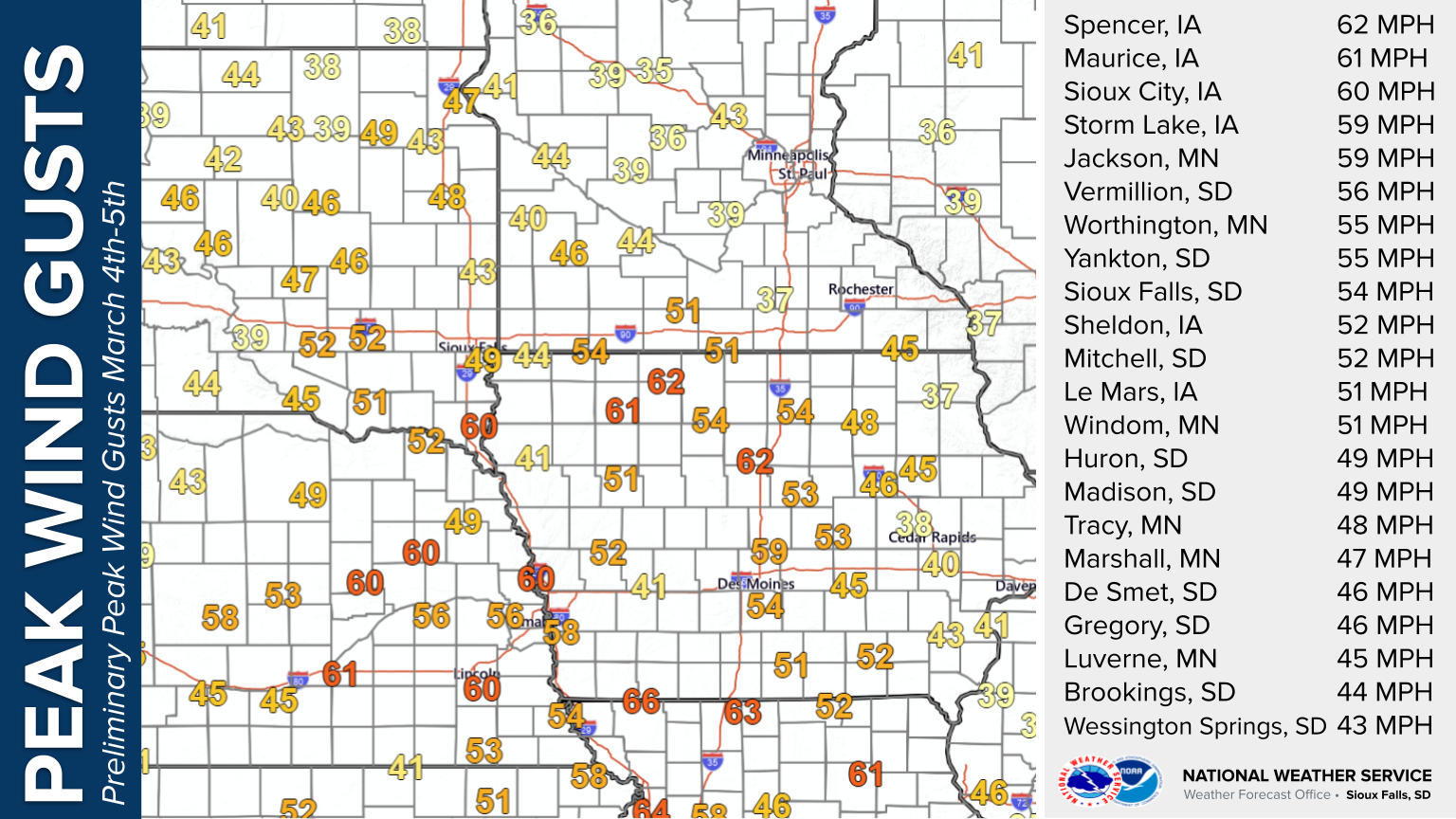 |
| Map of Peak Wind Gusts from 7 AM Tue March 4th to 7AM Wed March 5th, 2025 |
...PRELIMINARY HIGHEST WIND REPORTS THROUGH 7AM WEDNESDAY MARCH 5TH...

Location                     Speed     Time/Date       Provider

...Iowa...

...Buena Vista County...
Storm Lake Airport           59 MPH    0855 PM 03/04   AWOS
Storm Lake                   59 MPH    0120 AM 03/05   MESOWEST

...Cherokee County...
Cherokee Municipal Airport   46 MPH    0344 AM 03/05   AWOS
Marcus                       45 MPH    0830 PM 03/04   DAVIS

...Clay County...
Spencer Municipal Airport    62 MPH    0120 AM 03/05   ASOS

...Dickinson County...
TERRIL                       56 MPH    1219 AM 03/05   CWOP
Lake Park                    49 MPH    1210 AM 03/05   CWOP
Spirit Lake                  49 MPH    0326 AM 03/05   CWOP
Milford                      49 MPH    0200 AM 03/05   CWOP

...Ida County...
Battle Creek                 59 MPH    0115 AM 03/05   DAVIS

...OBrien County...
Sheldon Airport              52 MPH    0355 AM 03/05   AWOS

...Osceola County...
MAY CITY                     51 MPH    0240 PM 03/04   CWOP
Sibley                       47 MPH    0135 PM 03/04   MESOWEST

...Plymouth County...
Le Mars Airport              51 MPH    0855 PM 03/04   AWOS
Remsen                       45 MPH    1245 AM 03/05   DAVIS

...Sioux County...
1 NE Maurice                 61 MPH    0255 AM 03/05   AWOS
Alton                        53 MPH    1235 AM 03/05   MESOWEST
Hawarden                     48 MPH    0205 AM 03/05   CWOP

...Woodbury County...
Sioux Gateway Airport        60 MPH    0315 AM 03/05   ASOS
Sioux City                   53 MPH    0405 AM 03/05   MESOWEST
Sioux City                   51 MPH    0141 AM 03/05   CWOP
Moville                      49 MPH    0855 PM 03/04   MESOWEST

...Minnesota...

...Cottonwood County...
T.h.60 - Mountain Lake - Mp  56 MPH    1230 AM 03/05   MESOWEST
Windom Municipal Airport     51 MPH    0215 AM 03/05   AWOS
T.h.71 - Jeffers - Mp 43     47 MPH    1155 PM 03/04   MESOWEST

...Jackson County...
Jackson Airport              59 MPH    0215 AM 03/05   AWOS
I-90 - Lakefield - Mp 67     56 MPH    0135 AM 03/05   MESOWEST

...Lincoln County...
T.h.19 - Hendricks - Mp 2    48 MPH    0200 AM 03/05   MESOWEST

...Lyon County...
U.s.14 - Florence - Mp 21.2  64 MPH    1240 AM 03/05   MESOWEST
T.h.68 - Taunton - Mp 22.9   53 MPH    0135 AM 03/05   MESOWEST
Tracy Airport                48 MPH    1155 PM 03/04   AWOS
Marshall Municipal Airport   47 MPH    0313 AM 03/05   AWOS

...Murray County...
T.h.30 - Dovray - Mp 49      49 MPH    0340 AM 03/05   MESOWEST
Slayton Municipal Airport    44 MPH    0933 PM 03/04   AWOS

...Nobles County...
Worthington Airport          55 MPH    1158 PM 03/04   AWOS
I-90 - Rushmore - Mp 35      49 MPH    0110 PM 03/04   MESOWEST

...Pipestone County...
U.s.75 - Trosky - Mp 30.3    59 MPH    0430 AM 03/05   MESOWEST
Redstone RAWS                51 MPH    0921 PM 03/04   RAWS

...Rock County...
I-90 - Beaver Creek Mp 4     59 MPH    0915 PM 03/04   MESOWEST
I-90 - Magnolia - Mp 21.6    54 MPH    0225 AM 03/05   MESOWEST
Luverne                      49 MPH    1230 AM 03/05   CWOP
Hardwick                     47 MPH    0745 PM 03/04   DAVIS
Luverne Airport              45 MPH    1035 PM 03/04   AWOS

...Nebraska...

...Dixon County...
Concord 2E                   47 MPH    0250 AM 03/05   NE-MESO

...South Dakota...

...Aurora County...
SD RWIS Plankinton           53 MPH    0335 PM 03/04   SDDOT
White Lake (SD Mesonet)      48 MPH    1115 PM 03/04   SDSMESO

...Beadle County...
Huron Regional Airport       49 MPH    0305 PM 03/04   ASOS
SD RWIS Cavour               48 MPH    0340 PM 03/04   SDDOT

...Bon Homme County...
SD RWIS Tyndall              56 MPH    0810 PM 03/04   SDDOT
Scotland                     42 MPH    0525 AM 03/05   DAVIS

...Brookings County...
Volga (SD Mesonet)           46 MPH    1250 AM 03/05   SDSMESO
Brookings 2NE                45 MPH    0550 PM 03/04   SDSMESO
Brookings Municipal Airport  44 MPH    1209 AM 03/05   AWOS
Astoria 4 SSE (SD Mesonet)   42 MPH    1105 PM 03/04   SDSMESO
White                        40 MPH    1130 PM 03/04   DAVIS
Elkton                       40 MPH    0335 PM 03/04   CWOP

...Brule County...
SD RWIS Kimball              52 MPH    1114 AM 03/04   SDDOT

...Charles Mix County...
SD RWIS WAGNER               59 MPH    0102 AM 03/05   SDDOT
SD RWIS Platte-Winner Bridge 58 MPH    1135 AM 03/04   SDDOT
Lake Andes RAWS              48 MPH    0341 PM 03/04   RAWS
Wagner                       44 MPH    0225 PM 03/04   DAVIS
Wagner                       43 MPH    0955 PM 03/04   AWOS

...Clay County...
Vermillion                   56 MPH    0215 AM 03/05   AWOS
Beresford 7 WSW (SD Mesonet) 54 MPH    0350 AM 03/05   SDSMESO
Wakonda                      50 MPH    0835 PM 03/04   DAVIS

...Davison County...
Mitchell Municipal Airport   52 MPH    0306 AM 03/05   ASOS
Mount Vernon                 49 MPH    0940 PM 03/04   SDSMESO

...Douglas County...
SD RWIS Corsica              58 MPH    0200 AM 03/05   SDDOT
Armour                       43 MPH    1155 PM 03/04   DAVIS

...Gregory County...
SD RWIS Dallas               60 MPH    0904 AM 03/04   SDDOT
SD RWIS Ft. Randall Dam      55 MPH    0333 AM 03/05   SDDOT
SD RWIS Dixon                55 MPH    1044 AM 03/04   SDDOT
Gregory 16N                  48 MPH    0405 AM 03/05   SDSMESO
Butte 8NNW                   47 MPH    0200 PM 03/04   CWOP
Gregory 7SSW                 46 MPH    0340 PM 03/04   SDSMESO

...Hanson County...
SD RWIS Alexandria           61 MPH    1020 PM 03/04   SDDOT

...Hutchinson County...
Menno 7ESE                   59 MPH    0810 PM 03/04   SDSMESO
SD RWIS Freeman              56 MPH    1156 PM 03/04   SDDOT
SD RWIS Tripp                55 MPH    0855 PM 03/04   SDDOT
Parkston (SD Mesonet)        45 MPH    0200 PM 03/04   SDSMESO

...Jerauld County...
SD RWIS Lane                 53 MPH    1109 AM 03/04   SDDOT
2 ESE Wessington Springs     43 MPH    0755 PM 03/04   AWOS

...Kingsbury County...
SD RWIS Arlington            53 MPH    1111 PM 03/04   SDDOT
De Smet 7N                   47 MPH    1250 AM 03/05   SDSMESO
3 NNW De Smet                46 MPH    0215 AM 03/05   AWOS

...Lake County...
Madison 6S                   51 MPH    1250 AM 03/05   SDSMESO
Madison Airport              49 MPH    0415 PM 03/04   AWOS

...Lincoln County...
SD RWIS Davis                57 MPH    1035 PM 03/04   SDDOT
Tea                          47 MPH    1235 AM 03/05   AWOS

...McCook County...
SD RWIS STANLEY CORNER       58 MPH    0202 AM 03/05   SDDOT
SD RWIS Montrose             55 MPH    1231 AM 03/05   SDDOT
Canova                       46 MPH    0115 AM 03/05   CWOP

...Miner County...
SD RWIS Howard               48 MPH    0336 PM 03/04   SDDOT

...Minnehaha County...
Sioux Falls Airport          53 MPH    0655 PM 03/04   ASOS
Sioux Falls (SD Mesonet)     44 MPH    0625 PM 03/04   SDSMESO
Sioux Falls 10 WSW (SD Meson 44 MPH    0340 AM 03/05   SDSMESO

...Moody County...
SD RWIS Ward                 55 MPH    0315 PM 03/04   SDDOT
Flandreau 3 NNE (SD Mesonet) 49 MPH    1155 PM 03/04   SDSMESO
Colman                       45 MPH    0205 AM 03/05   DAVIS

...Sanborn County...
SD RWIS Forestburg           53 MPH    0105 PM 03/04   SDDOT
Woonsocket 4NNW              51 MPH    0205 AM 03/05   SDSMESO
Letcher 2ENE                 47 MPH    0915 PM 03/04   SDSMESO

...Turner County...
SD RWIS Parker               58 MPH    0147 AM 03/05   SDDOT
SD RWIS IRENE                56 MPH    0413 AM 03/05   SDDOT
Parker 7NNE                  53 MPH    1250 AM 03/05   SDSMESO

...Union County...
SD RWIS Beresford            60 MPH    0156 AM 03/05   SDDOT
SD RWIS North Sioux City     48 MPH    1209 AM 03/05   SDDOT

...Yankton County...
SD RWIS Gayville             58 MPH    1115 PM 03/04   SDDOT
Yankton Municipal Airport    55 MPH    0246 AM 03/05   AWOS

Observations are collected from a variety of sources with varying
equipment and exposures. We thank all volunteer weather observers
for their dedication. Not all data listed are considered official.
Snow/Ice
Snow totals ranged from a half inch or less in eastern SD to 4+ inches near Huron, SD and Windom, MN.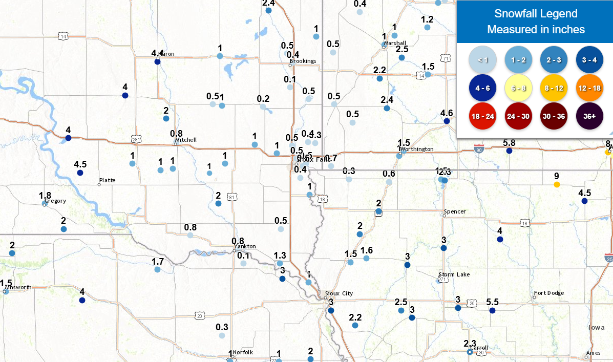 |
| Map of snowfall totals for March 4-5, 2025 ranges from a tenth inch of snow in far southeast South Dakota to as much as 4+ inches near Huron, SD and Windom, MN. Snowfall reports are compiled from spotters and CoCoRaHs and cooperative weather observers. |
...SNOWFALL REPORTS FOR MARCH 4TH and 5TH...
Location                     Amount    Time/Date       Provider

...Iowa...

...Cherokee County...
0.9 NE Cherokee              3.0 in    0800 AM 03/05   COOP

...Dickinson County...
1 W Spirit Lake              2.3 in    0700 AM 03/05   CO-OP Observer

...Ida County...
1 WSW Ida Grove              3.0 in    0700 AM 03/05   Trained Spotter
Holstein 6.8 SSW             2.5 in    0700 AM 03/05   COCORAHS

...Lyon County...
Rock Rapids                  0.3 in    0800 AM 03/05   CO-OP Observer

...OBrien County...
Sheldon                      2.0 in    0700 AM 03/05   CO-OP Observer

...Osceola County...
Sibley                       0.6 in    0730 AM 03/05   CO-OP Observer

...Plymouth County...
Remsen                       1.6 in    1000 AM 03/05   COOP
Le Mars                      1.5 in    0800 AM 03/05   COOP

...Sioux County...
Orange City                  2.0 in    0700 AM 03/05   COOP

...Woodbury County...
Sergeant Bluff               3.0 in    0600 AM 03/05   Official NWS Obs
3.4 N Hornick                2.2 in    0700 AM 03/05   COOP

...Minnesota...

...Cottonwood County...
1 NNE Windom                 4.6 in    0800 AM 03/05   CO-OP Observer

...Lincoln County...
Hendricks 8.0 SE             0.5 in    0700 AM 03/05   COCORAHS

...Lyon County...
Milroy 4.1 SSW               2.5 in    0700 AM 03/05   COCORAHS
Balaton 2.1 SE               2.2 in    0700 AM 03/05   COCORAHS
4 S Cottonwood               1.0 in    0900 AM 03/05   COCORAHS
Marshall                     1.0 in    0800 AM 03/05   COOP

...Murray County...
Slayton 0.8 SSW              2.4 in    0700 AM 03/05   COCORAHS

...Nobles County...
Worthington 1.9 SW           1.0 in    0700 AM 03/05   COCORAHS

...Pipestone County...
1 NNW Pipestone              0.5 in    0800 AM 03/05   CO-OP Observer
Edgerton 0.2 WSW             0.5 in    0600 AM 03/05   COCORAHS

...Rock County...
Hills 0.2 NW                 0.7 in    0700 AM 03/05   COCORAHS

...Nebraska...

...Dixon County...
Newcastle                    3.0 in    0600 AM 03/05   COOP

...South Dakota...

...Aurora County...
Stickney 3.8 SW              1.0 in    0700 AM 03/05   COCORAHS

...Beadle County...
2 S Huron                    4.4 in    0600 AM 03/05   Official NWS Obs

...Bon Homme County...
Tyndall                      0.8 in    0700 AM 03/05   CO-OP Observer

...Brookings County...
Astoria 2.2 SSE              1.0 in    0700 AM 03/05   COCORAHS
Brookings 6.5 NNW            0.5 in    0700 AM 03/05   COCORAHS
2 NE Brookings               0.4 in    0800 AM 03/05   CO-OP Observer

...Brule County...
Pukwana 1.9 S                4.0 in    0700 AM 03/05   COCORAHS

...Clay County...
Vermillion 1.4 SE            1.3 in    0600 AM 03/05   COCORAHS
5.9 SE Centerville           0.5 in    0800 AM 03/05   COOP

...Davison County...
Ethan 4.5 WSW                1.0 in    0600 AM 03/05   COCORAHS
1 SE Mitchell                0.8 in    0600 AM 03/05   Official NWS Obs

...Douglas County...
Dimock 10.2 W                1.0 in    0700 AM 03/05   COCORAHS

...Gregory County...
Burke 10.5 SSE               2.0 in    0700 AM 03/05   COCORAHS
Gregory                      1.8 in    0700 AM 03/05   COOP
1 WNW Gregory                1.8 in    0700 AM 03/05   CO-OP Observer

...Hutchinson County...
Emery 10.8 S                 0.1 in    0600 AM 03/05   COCORAHS

...Jerauld County...
Wessington Springs           4.0 in    0700 AM 03/05   COOP

...Kingsbury County...
De Smet 0.2 SSE              1.0 in    0700 AM 03/05   COCORAHS

...Lake County...
Madison 2SE                  0.2 in    0900 AM 03/05   COOP

...Lincoln County...
Canton                       1.0 in    0610 AM 03/05   COOP
Harrisburg 0.8 NNE           0.4 in    0700 AM 03/05   COCORAHS

...McCook County...
Montrose                     1.0 in    0900 AM 03/05   COOP
Bridgewater                  1.0 in    0800 AM 03/05   CO-OP Observer

...Miner County...
1 SSW Howard                 1.0 in    0930 AM 03/05   CO-OP Observer
Howard 5.3 W                 0.5 in    0700 AM 03/05   COCORAHS

...Minnehaha County...
Hartford 0.5 N               1.0 in    0600 AM 03/05   COCORAHS
4 ESE Sioux Falls            0.5 in    0800 AM 03/05   NWS Employee
Renner 4.1 NW                0.5 in    0700 AM 03/05   COCORAHS
Sioux Falls 5.2 E            0.5 in    0700 AM 03/05   COCORAHS
3 N Sioux Falls              0.5 in    0600 AM 03/05   Official NWS Obs
5 W Garretson                0.4 in    0700 AM 03/05   COCORAHS
Garretson 1.7 WSW            0.3 in    0700 AM 03/05   COCORAHS

...Moody County...
Flandreau                    0.5 in    0630 AM 03/05   CO-OP Observer
Colman 10.6 N                0.1 in    0700 AM 03/05   COCORAHS

...Sanborn County...
Letcher 0.5 E                2.0 in    0700 AM 03/05   COCORAHS

...Union County...
Jefferson 2.1 WNW            1.0 in    0700 AM 03/05   COCORAHS

...Yankton County...
2 ESE Yankton                0.8 in    0900 AM 03/05   CO-OP Observer

Observations are collected from a variety of sources with varying
equipment and exposures. We thank all volunteer weather observers
for their dedication. Not all data listed are considered official.
Photos & Video
Impacts across the region were greatest Tuesday night March 4th through Wednesday morning March 5th, 2025
 |
 |
 |
 |
| Small graupel was reported with a weak thunderstorm tracking through Yankton, SD at 7:30 AM March 4th (Paul Scherschligt) |
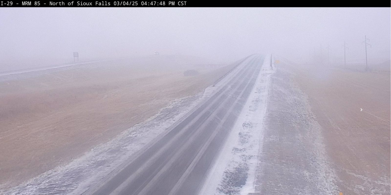
Low visibility was reported due to blowing snow and strong wind gusts north of Sioux Falls at 4:47 PM March 4th. (SDDOT) |
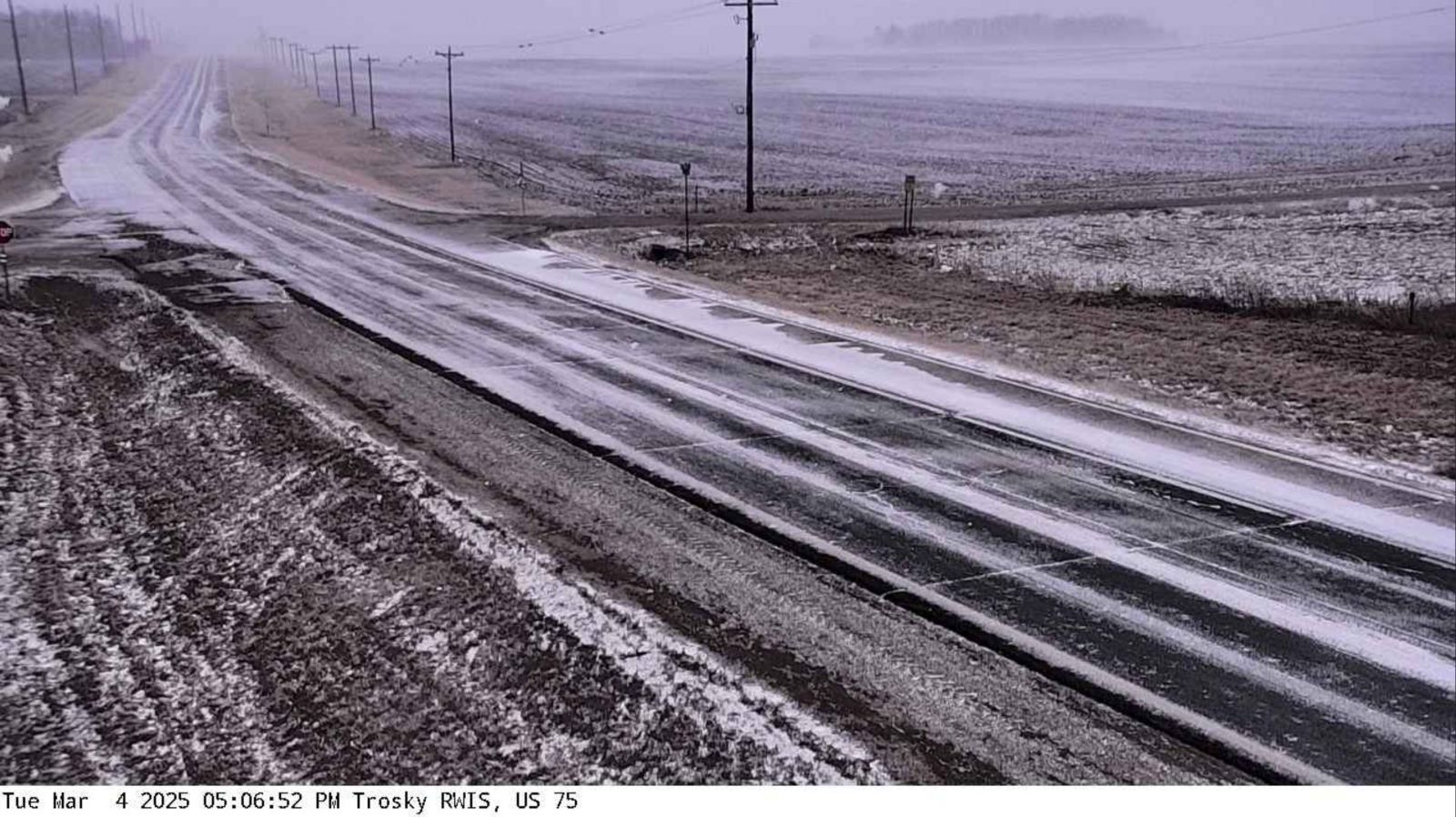
Low visibility was reported due to blowing snow and strong wind gusts near Trotsky, MN at 5:06 PM March 4th. (MNDOT) |
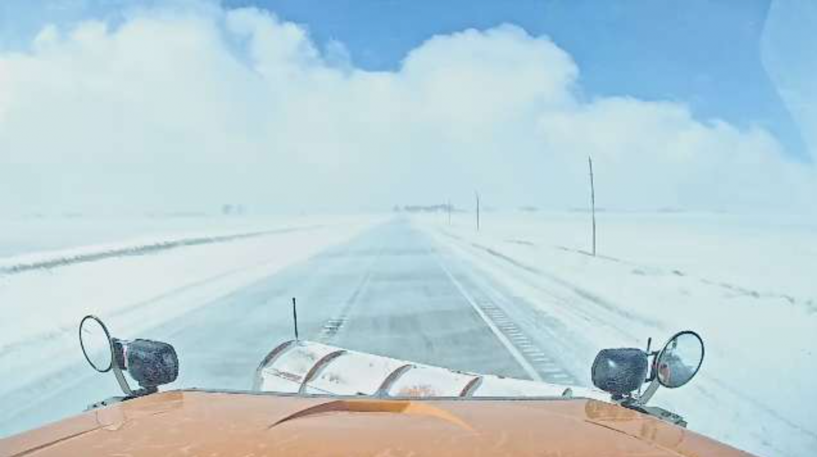
A snow plow camera just east of Adrian, MN shows near whiteout conditions at 5:51 PM March 4th. (MNDOT) |
 |
 |
 |
 |
| A snow plow camera shows low visibility due to blowing snow east of Cleghorn, IA at 11:30 AM March 5th. (IADOT) |
Light icing on trees and elevated surfaces was reported in Marshall, MN Tuesday evening March 4th as rain transitioned to snow. (Alex Peterson) |
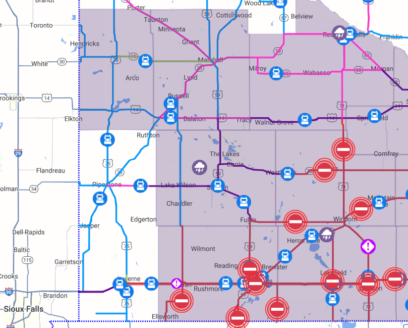
Most roads, including I-90, were closed or travel was not advised across southwest Minnesota on Wednesday morning March 5th, 2025. (MNDOT) |
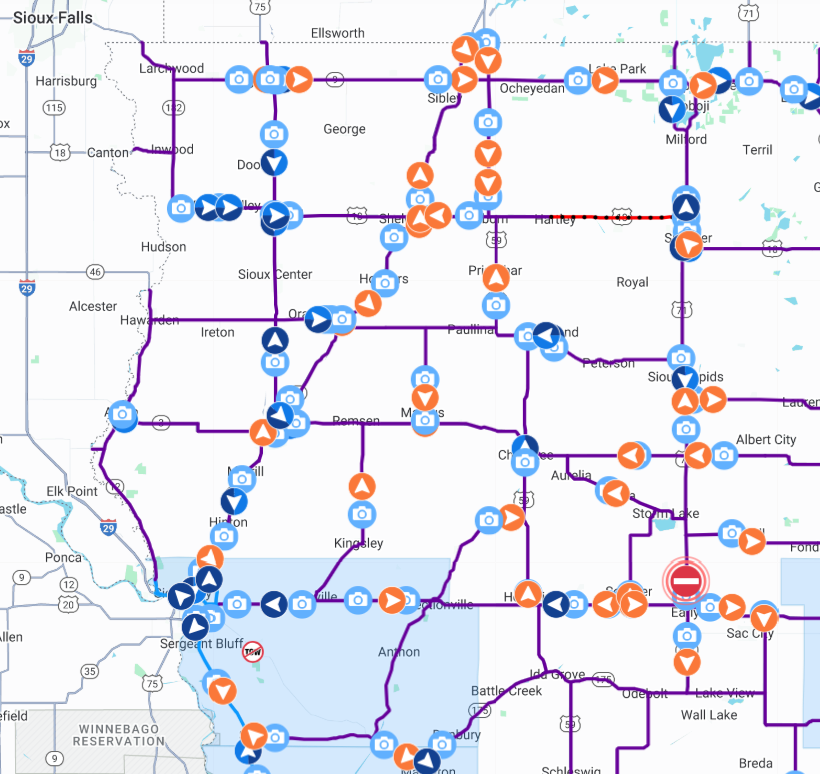
Most roads were closed or travel was not advised across northwest Iowa and far northeast Nebraska on Wednesday morning March 5th, 2025. (IADOT) |
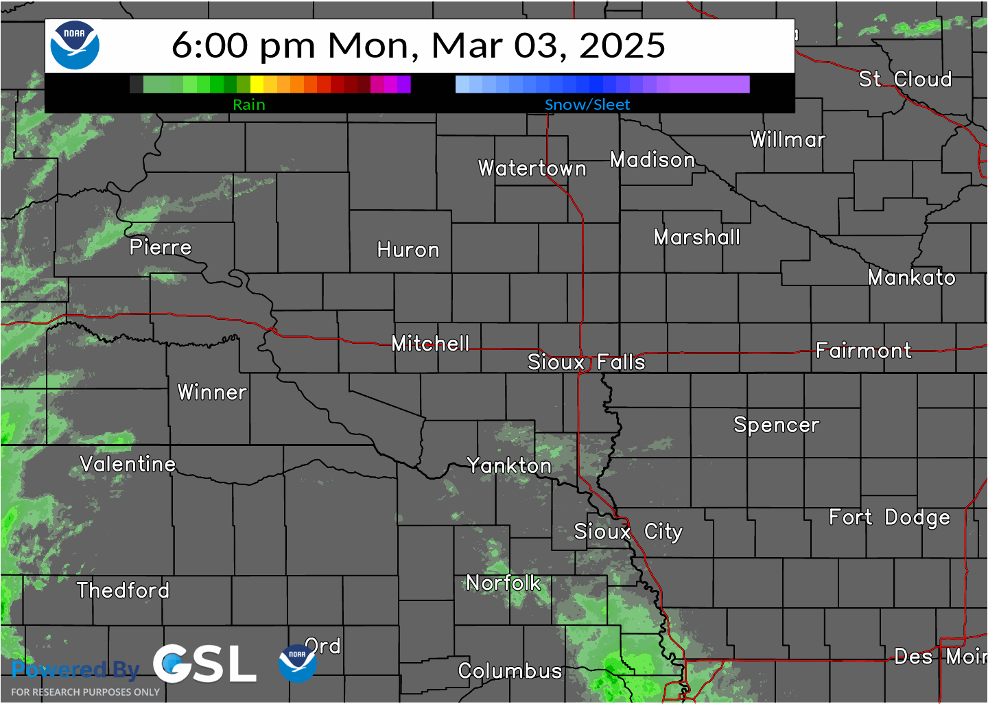
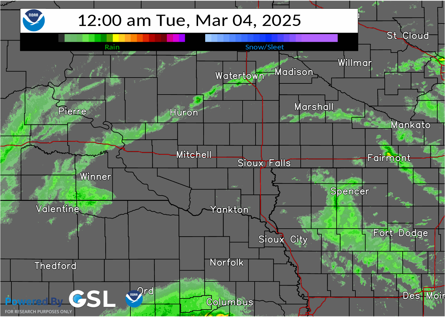
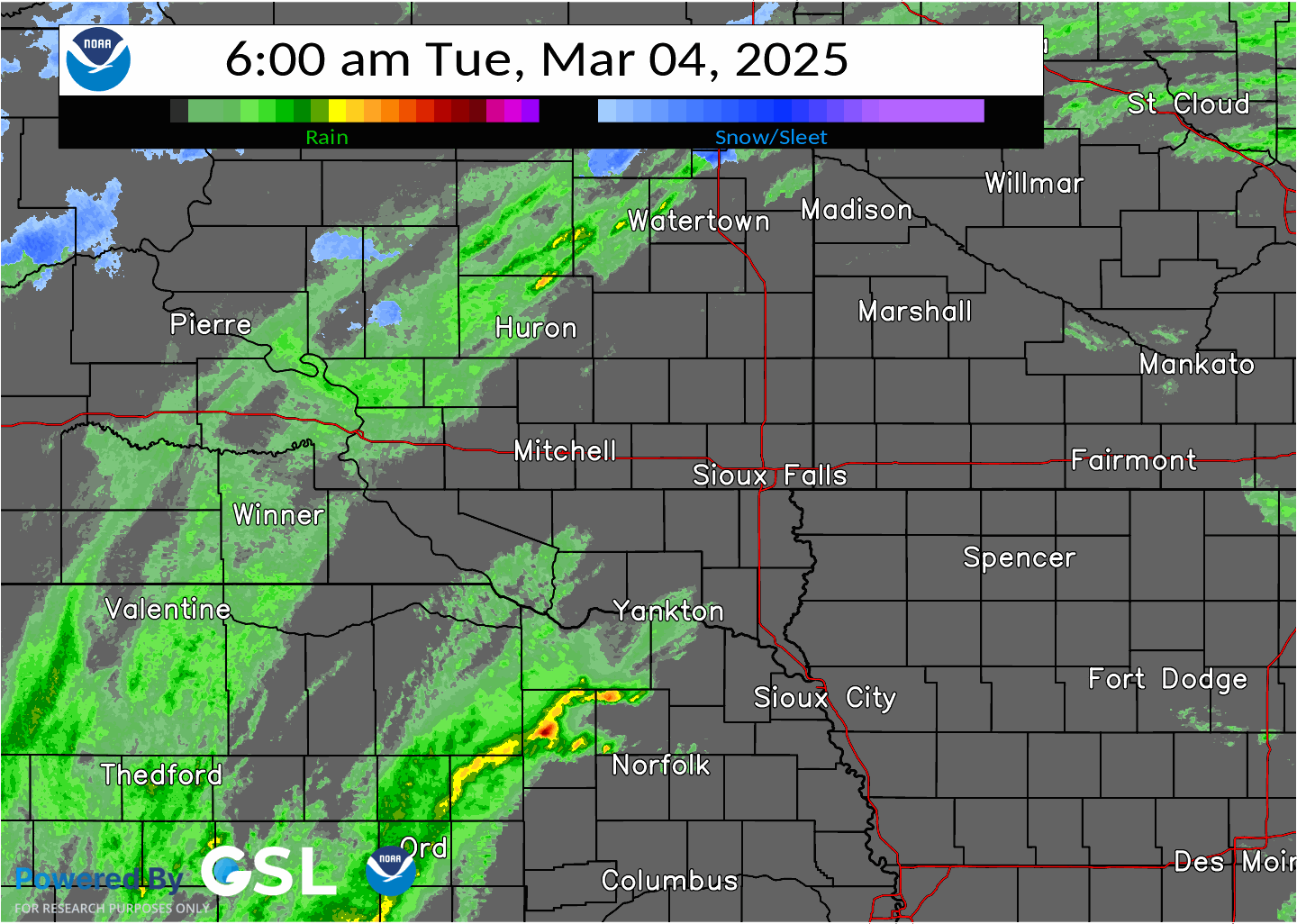
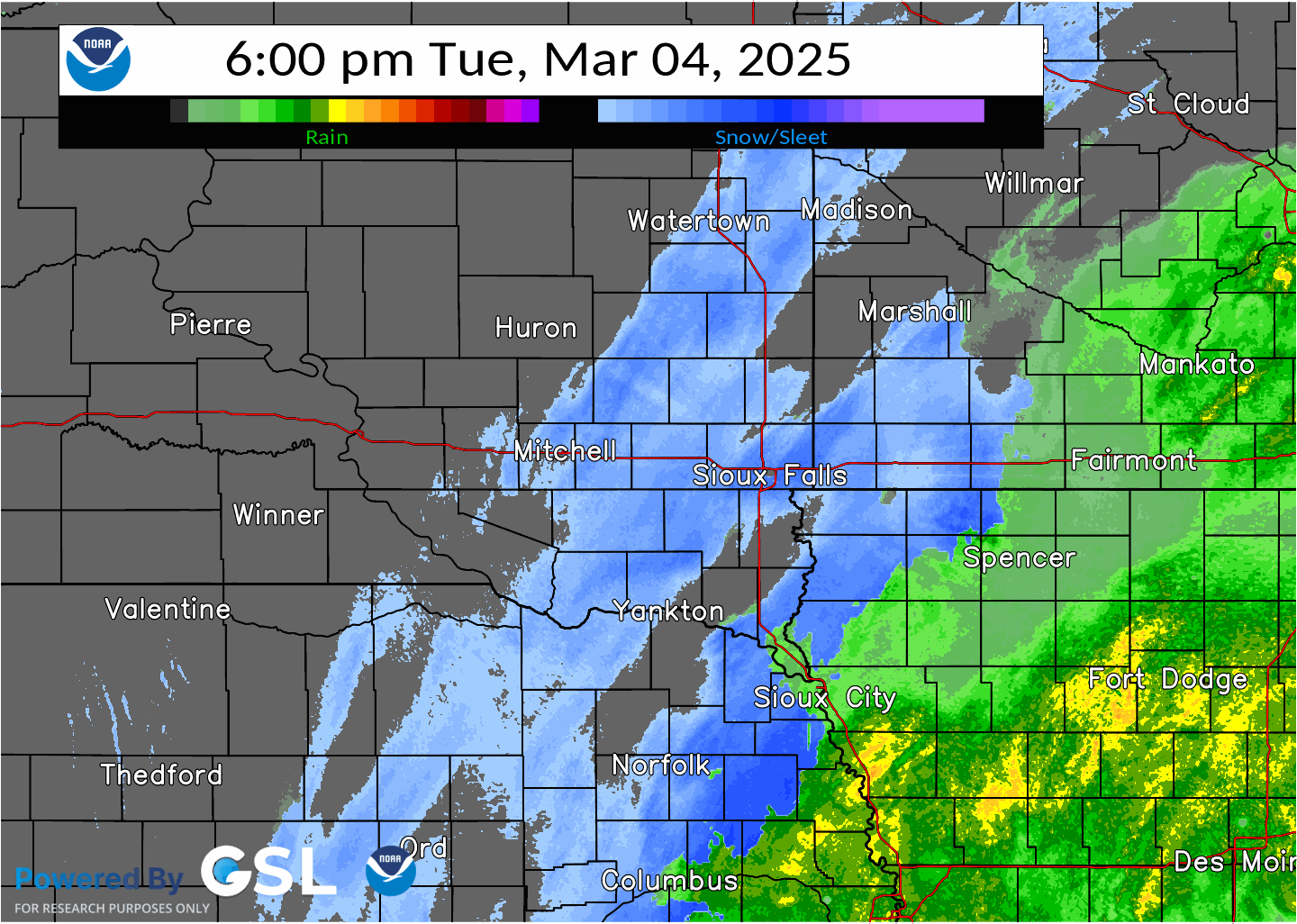
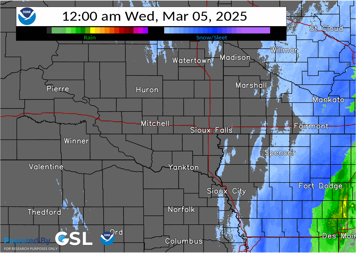
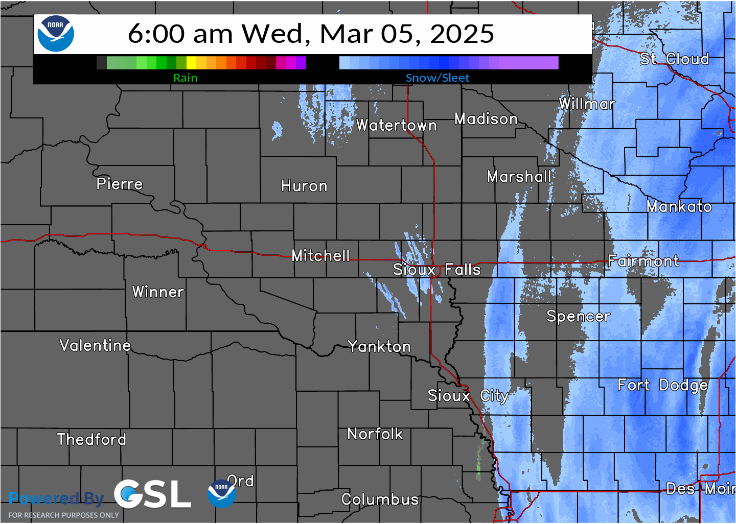
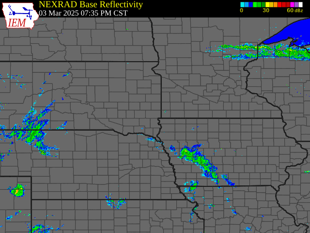
Radar
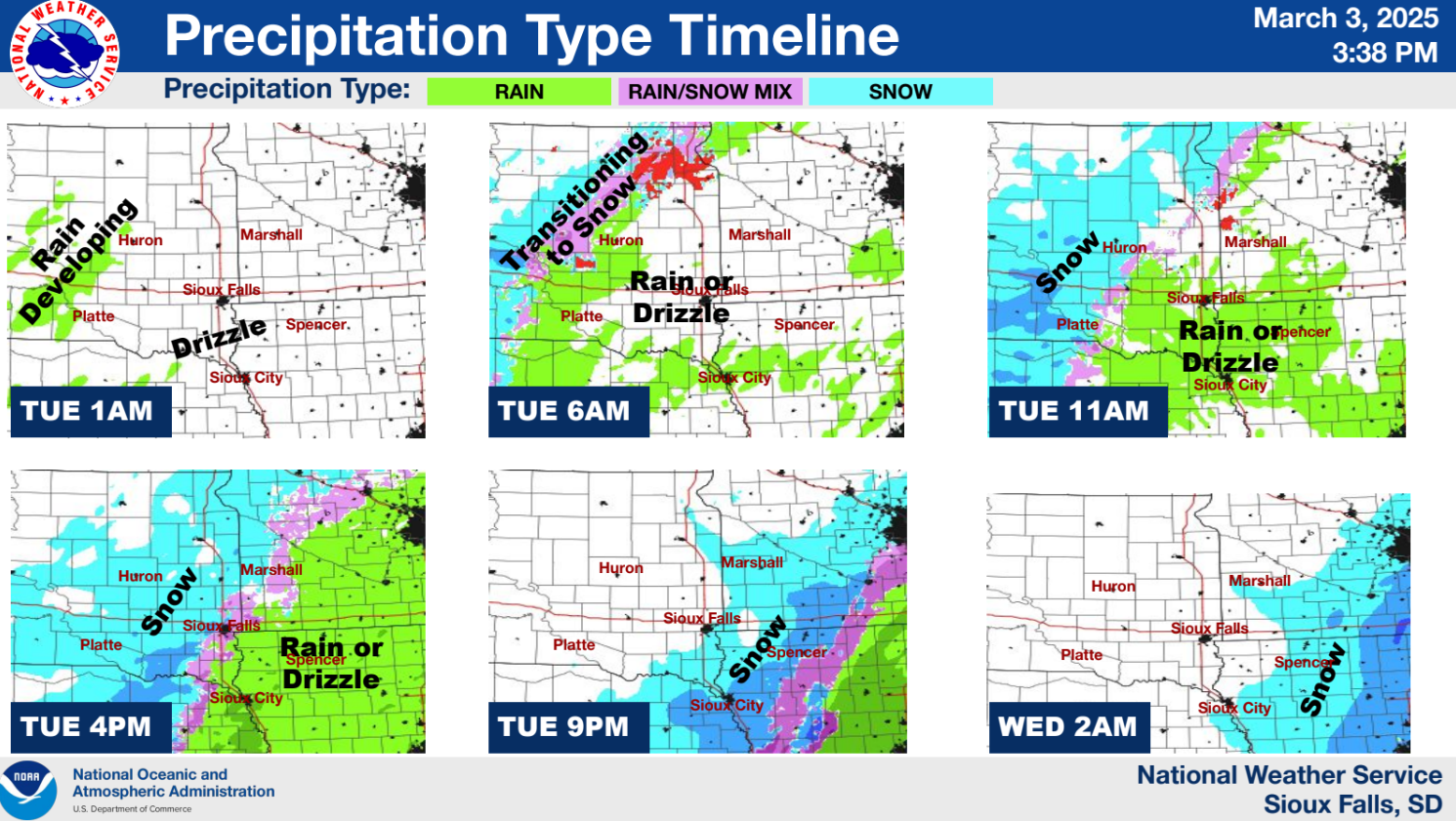
During this event, drizzle, light rain, and isolated thunderstorms quickly transitioned to light to moderate snow through the day and evening March 4th, 2025.
 |
 |
 |
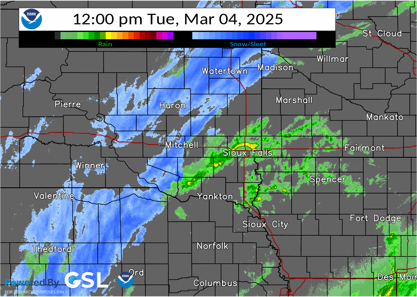 |
| Scattered rain showers spread north 6 PM March 3 to 12 AM March 4, 2025 | Scattered rain showers spread north 12 AM to 6 AM March 4, 2025 | Scattered rain showers and storms spread north, along with rain to snow transition west of James River Valley 6 AM to 12 PM March 4, 2025 | Scattered rain showers transition to snow from west to east 12 PM to 6 PM March 4, 2025 |
 |
 |
 |
 |
| Remaining rain showers transition to snow 6 PM March 4 to 12 AM March 5, 2025 | Light to moderate snow continues east of I-29 12 AM to 6 AM March 5, 2025 | Isolated snow tapers off west to east 6 AM to 12 PM March 5, 2025 | Regional mosaic radar reflectivity loop for the entire event from March 3rd through March 5th, 2025 |
Additional Information
The Forecast issued Monday afternoon March 3, 2025
 |
 |
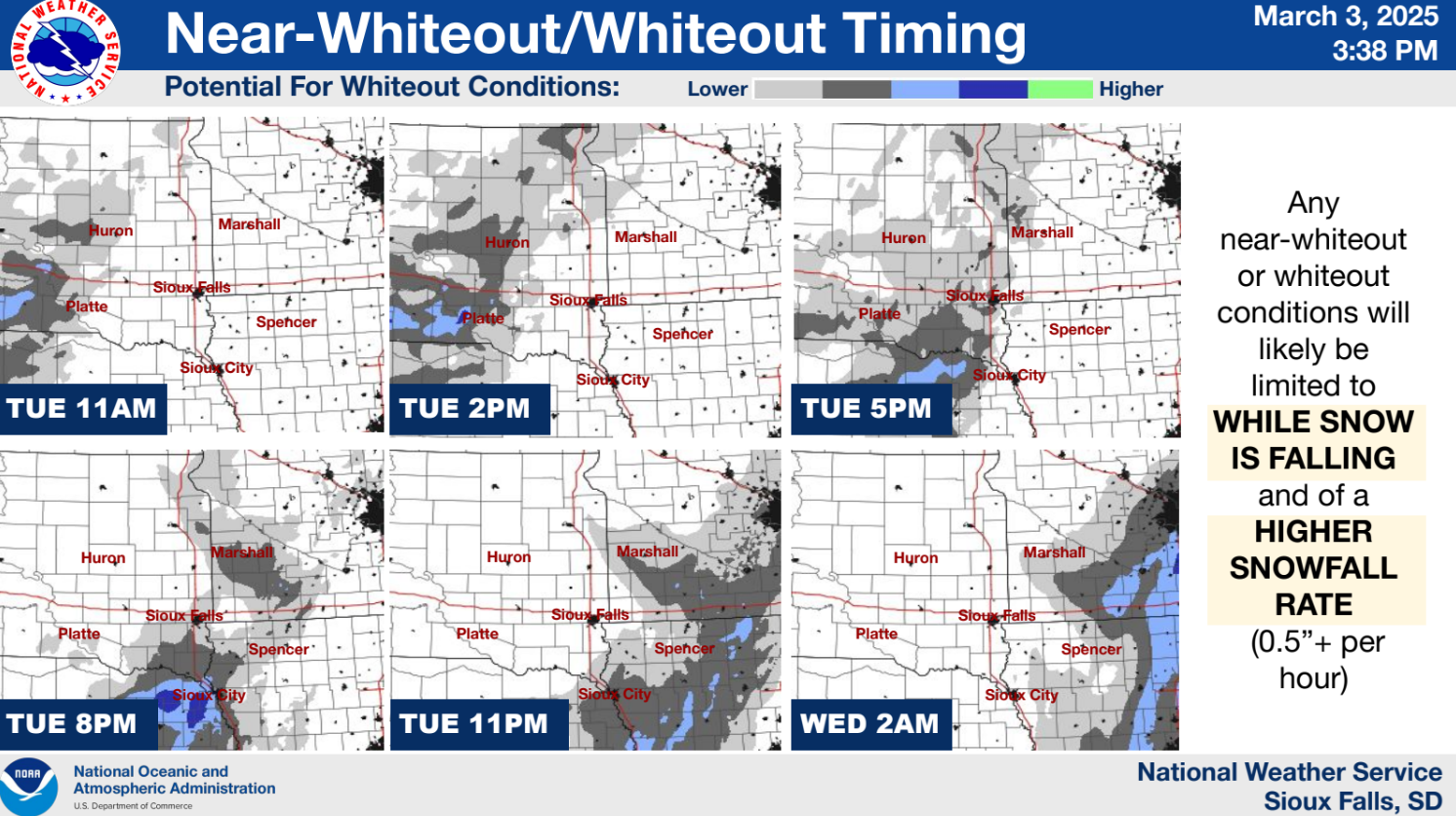 |
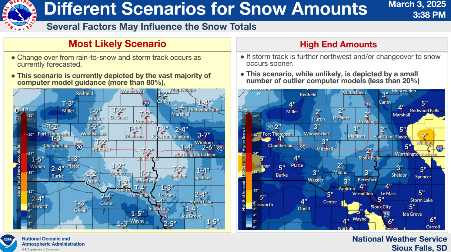
| Winter Weather Advisory and Winter Storm Watch | Precipitation Timing/Type Forecast | Timing of Near-Whiteout Conditions based on heavier snowfall rates |
 |
 |
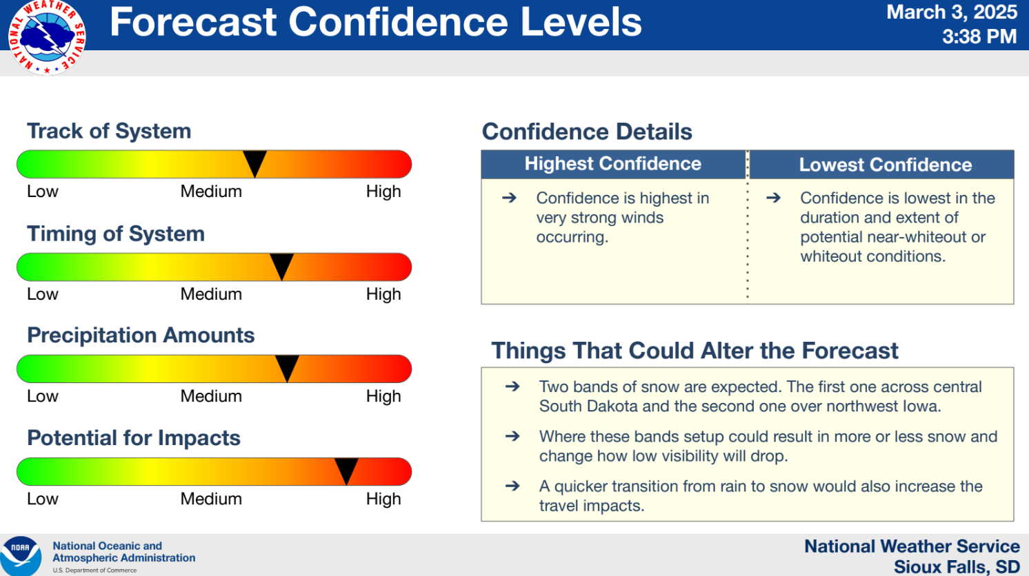 |
| Most likely and high end snowfall amounts | Timeline of peak wind gusts | Medium to high confidence in the track, timing, and precipitation amounts |
Summaries from other NWS Offices
 |
Media use of NWS Web News Stories is encouraged! Please acknowledge the NWS as the source of any news information accessed from this site. |
|


 Weather Story
 Weather Map
 Local Radar