Overview
|
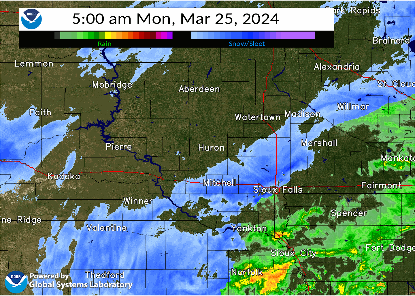
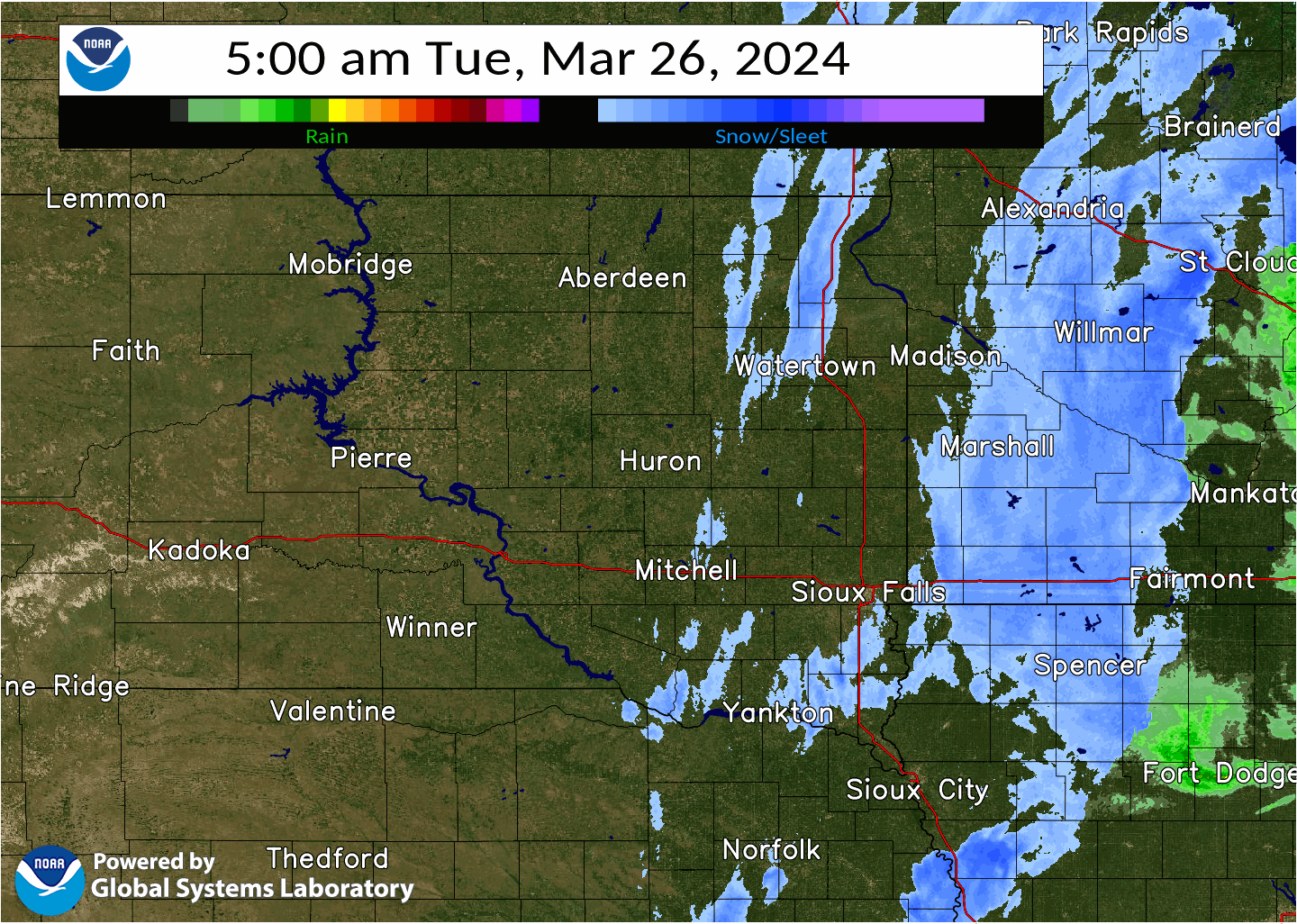
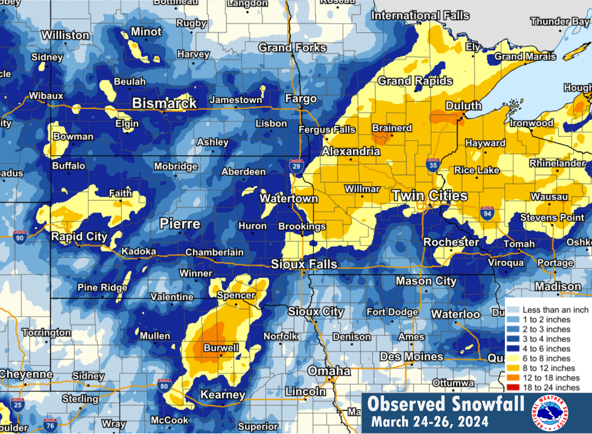
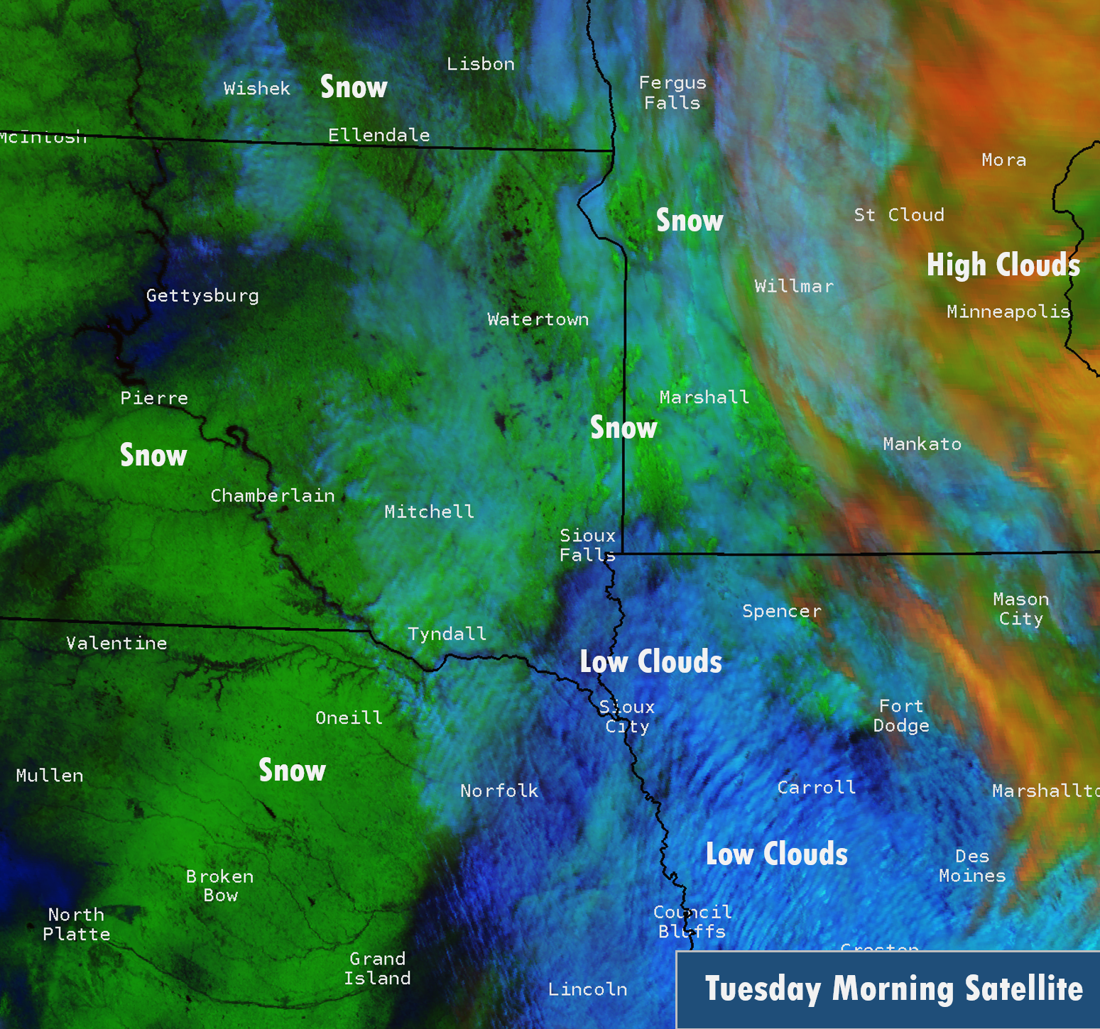
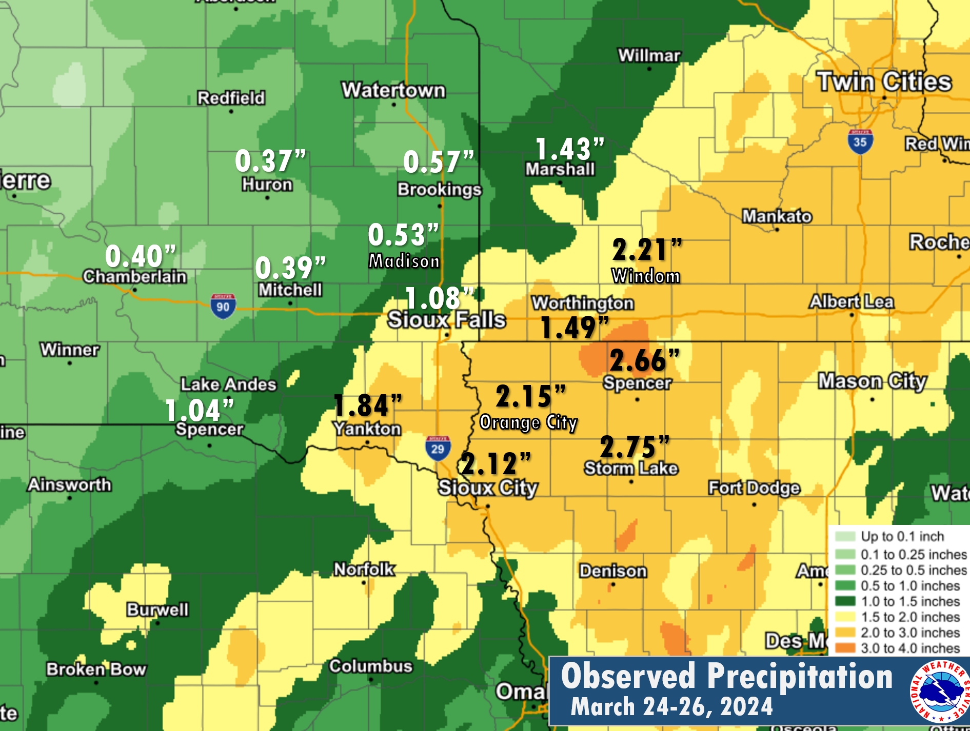
A prolonged winter storm impacted the broader region from March 24-26, 2024. This system not only produced rain, freezing rain, snow, and gusty winds - but also resulted in travel impacts mostly due to drifting and slippery road conditions across the region. Initially, this system would start off producing areas of light snowfall across central and eastern SD spreading the accumulations into portions of northwestern IA and southwestern MN during the day on March 24th. While only light snowfall accumulations were reported, slightly warmer temperatures during the afternoon hours would help most of the developing precipitation transition to rain especially south of I-90. However, light rain would gradually transitions to light snow overnight as temperatures cooled. By March 25th, mostly snow would continue into the early afternoon as a lull in activity develops through the evening hours. Lastly, another round of rain/snow would lift northwards during the late evening hours through portions of northwestern IA and southwestern MN. The wintery precipitation would continue through the morning hours of the March 26th before gradually dissipating. Overall, this prolonged event would produce over 10 inches of snowfall accumulations across the area along with up to 2.50 inches of rain over a three day period. Breezy northwesterly winds behind the system would lead to a few areas of drifting snow along with some minor travel impacts. |
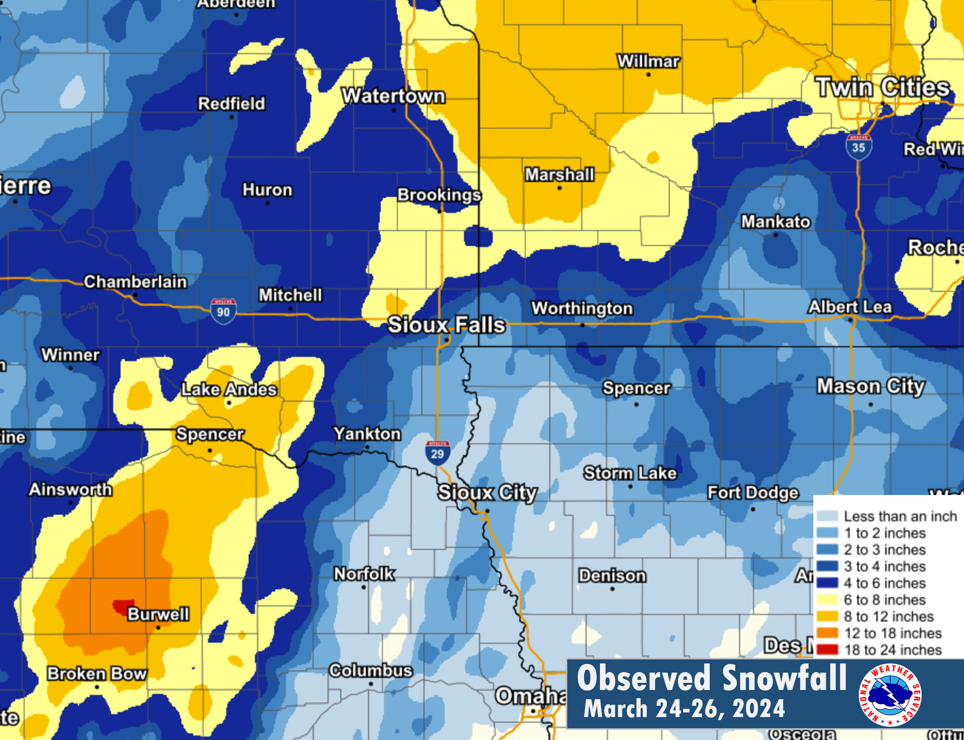 Storm Total Snowfall: March 24th - March 26th |
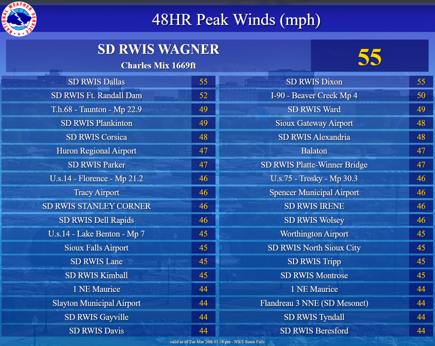
Wind:
As the system pushed off to the northeast on March 26th, strong northwesterly winds were left in its wake. Sustained wind speed between 20-30 mph along with wind gusts between 35-45 mph were recorded. A few isolated gusts up to 50+ mph were also recorded in more open and higher elevation areas.
 |
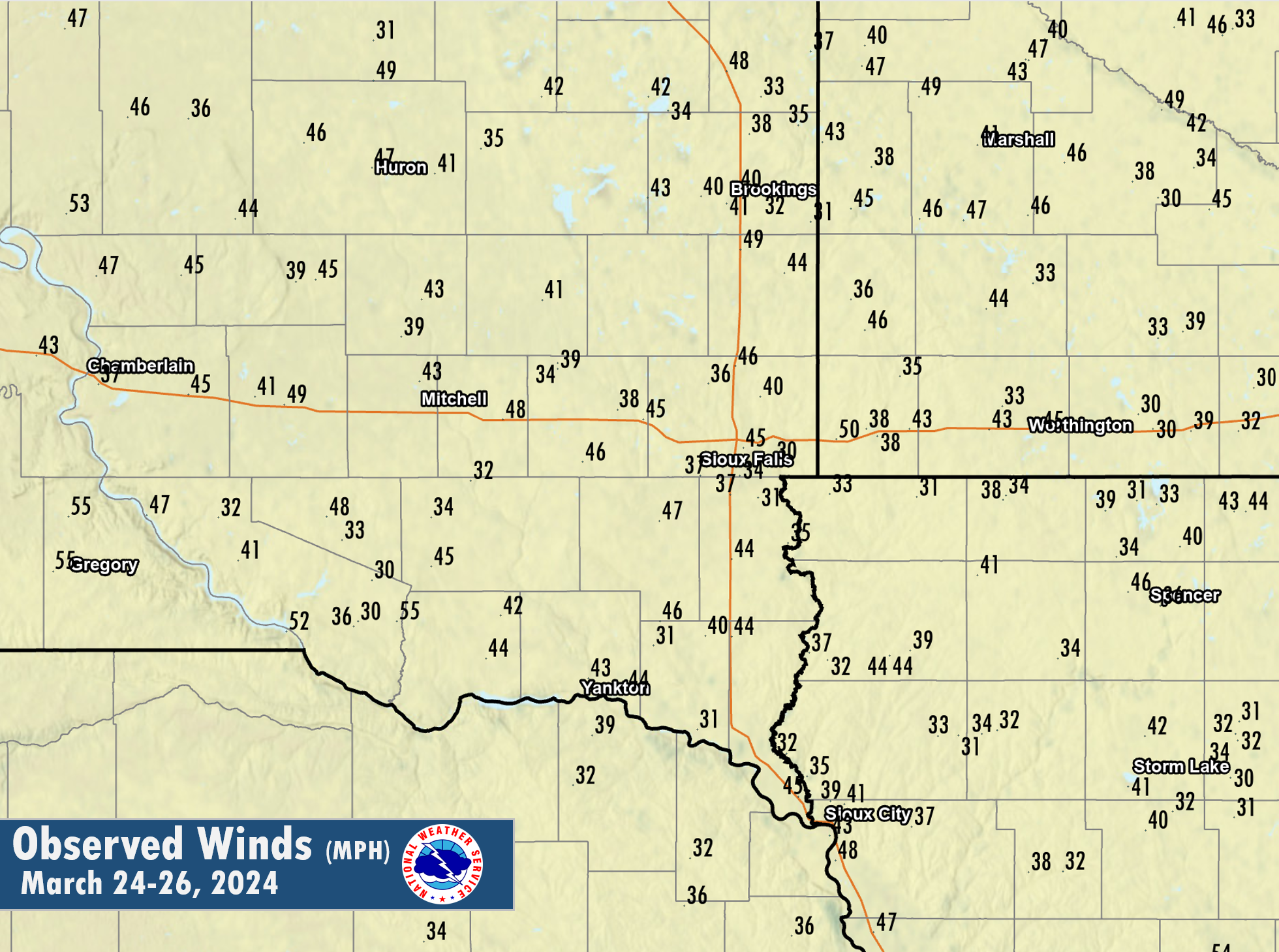 |
| 48 Hour Peak Gusts (MPH) | Regional Wind Gust Map (MPH) |
Photos & Video
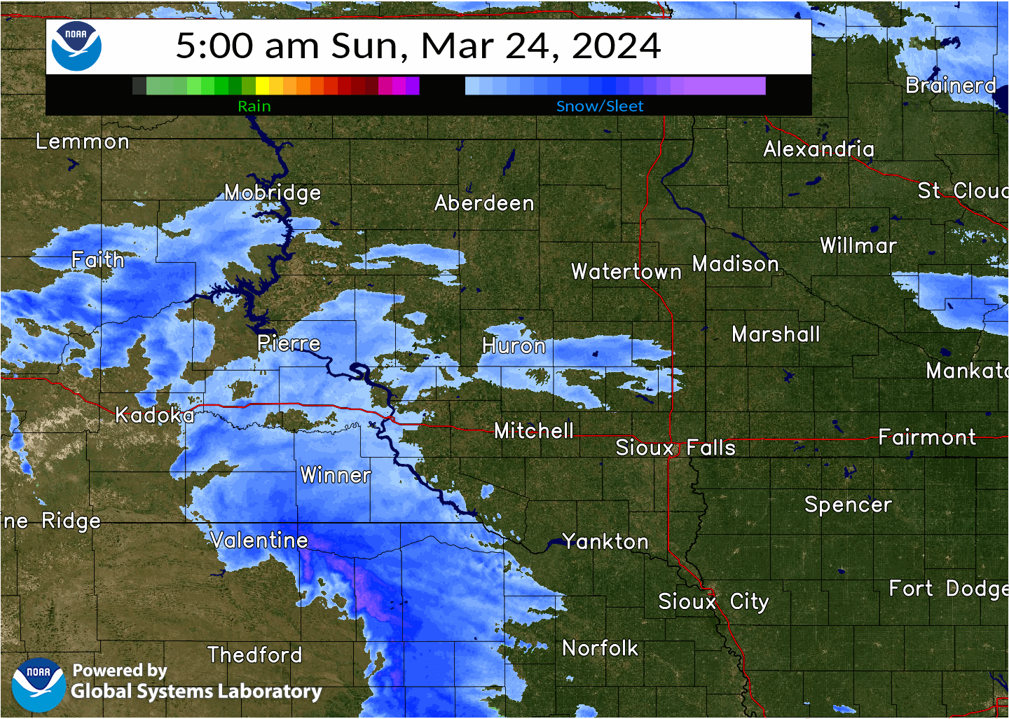
Radar
 |
 |
 |
|
MRMS Radar Loop 5 AM March 24th - 5 AM March 25th |
MRMS Radar Loop 5 AM March 25th - 5 AM March 26th |
MRMS Radar Loop 5 AM March 26th - 9 AM March 26th |
Snow & Rain
 |
 |
 |
|
Snowfall Totals Across the Region |
Satellite Imagery of the Fresh Accumulations |
Rainfall Accumulations Across the Area. |
Storm Reports
Preliminary Local Storm Report...Summary
National Weather Service Sioux Falls SD
1221 PM CDT Tue Mar 26 2024

..TIME...   ...EVENT...      ...CITY LOCATION...     ...LAT.LON...
..DATE...   ....MAG....      ..COUNTY LOCATION..ST.. ...SOURCE....
            ..REMARKS..

1217 PM     Snow             2 S Huron               44.34N 98.22W
03/26/2024  M2.8 Inch        Beadle             SD   CO-OP Observer

            Three day storm total snow.

1215 PM     Snow             Wessington Springs      44.08N 98.57W
03/26/2024  M8.0 Inch        Jerauld            SD   CO-OP Observer

            Three day storm total snow.

1210 PM     Snow             Menno                   43.24N 97.57W
03/26/2024  M5.2 Inch        Hutchinson         SD   CO-OP Observer

            Three day storm total snowfall.

1158 AM     Snow             Flandreau               44.05N 96.60W
03/26/2024  M6.8 Inch        Moody              SD   CO-OP Observer

            Three day storm total snow.

1154 AM     Snow             3 N Mitchell            43.77N 98.03W
03/26/2024  M4.3 Inch        Davison            SD   CO-OP Observer

            Three day storm total snow.

1152 AM     Snow             Colton                  43.79N 96.93W
03/26/2024  M10.5 Inch       Minnehaha          SD   CO-OP Observer

            Three day storm total snow.

1151 AM     Snow             5 W Bruce               44.43N 97.00W
03/26/2024  M3.7 Inch        Brookings          SD   Cocorahs

            Three day storm total snow.

1149 AM     Snow             1 SE Vermillion         42.77N 96.91W
03/26/2024  M0.6 Inch        Clay               SD   Public

            Three day storm total snow.

1148 AM     Snow             Sibley                  43.41N 95.75W
03/26/2024  M1.0 Inch        Osceola            IA   CO-OP Observer

            Three day storm total snow.

1147 AM     Snow             12 WNW Platte           43.48N 99.05W
03/26/2024  M6.3 Inch        Charles Mix        SD   CO-OP Observer

            Three day storm total snow.

1146 AM     Snow             1 NNW Pipestone         44.01N 96.33W
03/26/2024  M5.0 Inch        Pipestone          MN   CO-OP Observer

            Three day storm total snow.

1133 AM     Snow             2 ESE Yankton           42.88N 97.36W
03/26/2024  M3.5 Inch        Yankton            SD   CO-OP Observer

            Three day storm total snow.

1103 AM     Snow             Bridgewater             43.55N 97.50W
03/26/2024  M10.0 Inch       McCook             SD   CO-OP Observer

            Three day storm total snow.

1041 AM     Snow             3 N Sioux Falls         43.58N 96.73W
03/26/2024  M2.8 Inch        Minnehaha          SD   Official NWS Obs

            Three day storm total snow.

1035 AM     Snow             1 W Spirit Lake         43.42N 95.14W
03/26/2024  M3.2 Inch        Dickinson          IA   CO-OP Observer

            Three day storm total snow.

1034 AM     Snow             1 SSE Madison           43.99N 97.09W
03/26/2024  M4.1 Inch        Lake               SD   CO-OP Observer

            Three day storm total snow.

1033 AM     Snow             Sheldon                 43.18N 95.85W
03/26/2024  M1.5 Inch        O`Brien            IA   CO-OP Observer

            Three day storm total snow.

1033 AM     Snow             Orange City             43.01N 96.06W
03/26/2024  M0.9 Inch        Sioux              IA   CO-OP Observer

            Three day storm total snow.

1032 AM     Snow             2 NE Worthington        43.65N 95.58W
03/26/2024  M3.5 Inch        Nobles             MN   CO-OP Observer

            Three day storm total snow.

1032 AM     Snow             Windom                  43.87N 95.12W
03/26/2024  M4.4 Inch        Cottonwood         MN   CO-OP Observer

            Three day storm total snow.

1031 AM     Snow             1 N Marshall            44.47N 95.79W
03/26/2024  M8.5 Inch        Lyon               MN   CO-OP Observer

            Three day storm total snow.

1030 AM     Snow             Tyndall                 42.99N 97.87W
03/26/2024  M6.7 Inch        Bon Homme          SD   CO-OP Observer

            Three day storm total snow.

1029 AM     Snow             4 SSW Pickstown         43.02N 98.56W
03/26/2024  M9.5 Inch        Gregory            SD   CO-OP Observer

            Three day storm total snow.

1028 AM     Snow             Montrose                43.71N 97.19W
03/26/2024  M7.5 Inch        McCook             SD   CO-OP Observer

            Three day storm total snow.

1017 AM     Snow             4 SW Stickney           43.55N 98.49W
03/26/2024  M5.0 Inch        Aurora             SD   Cocorahs

            Three day storm total snow.

1017 AM     Snow             1 SSE Milford           43.31N 95.14W
03/26/2024  M1.7 Inch        Dickinson          IA   Cocorahs

            Three day storm total snow.

1016 AM     Snow             Hurley                  43.28N 97.09W
03/26/2024  E3.8 Inch        Turner             SD   Cocorahs

            Three day storm total snow.

1015 AM     Snow             6 NW Montrose           43.76N 97.27W
03/26/2024  E7.0 Inch        McCook             SD   Cocorahs

            Three day storm total snow.

1014 AM     Snow             Hills                   43.53N 96.36W
03/26/2024  M1.2 Inch        Rock               MN   Cocorahs

            Three day storm total snow.

1014 AM     Snow             4 NE Colton             43.83N 96.87W
03/26/2024  M10.0 Inch       Minnehaha          SD   Cocorahs

            Three day storm total snow.

1013 AM     Snow             3 ESE Sioux Falls       43.53N 96.67W
03/26/2024  M3.0 Inch        Minnehaha          SD   Cocorahs

            Three day storm total snow.

1013 AM     Snow             6 W Garretson           43.72N 96.61W
03/26/2024  M2.5 Inch        Minnehaha          SD   Cocorahs

            Three day storm total snow.

1012 AM     Snow             9 S Dallas              43.11N 99.52W
03/26/2024  M6.0 Inch        Gregory            SD   Cocorahs

            Three day storm total snow.

1011 AM     Snow             2 S Pukwana             43.75N 99.18W
03/26/2024  M4.5 Inch        Brule              SD   Cocorahs

            Three day storm total snow.

1011 AM     Snow             8 SSW Chamberlain       43.71N 99.38W
03/26/2024  M4.4 Inch        Brule              SD   Cocorahs

            Three day storm total snow.

1010 AM     Snow             Edgerton                43.87N 96.13W
03/26/2024  M2.5 Inch        Pipestone          MN   Cocorahs

            Three day storm total snow.

1009 AM     Snow             8 N Tracy               44.36N 95.60W
03/26/2024  M8.0 Inch        Lyon               MN   Cocorahs

            Three day storm total snow.

1008 AM     Snow             2 SE Balaton            44.21N 95.84W
03/26/2024  M9.8 Inch        Lyon               MN   Cocorahs

            Corrects previous snow report from 2 SE
            Balaton. Three day storm total snow.

1007 AM     Snow             6 ESE Nunda             44.13N 96.90W
03/26/2024  M7.5 Inch        Lake               SD   Cocorahs

            Three day storm total snow.

1007 AM     Snow             1 SW Brookings          44.29N 96.81W
03/26/2024  M7.5 Inch        Brookings          SD   Cocorahs

            Three day storm total snow.

1006 AM     Snow             5 SW Ivanhoe            44.41N 96.34W
03/26/2024  M8.5 Inch        Lincoln            MN   Cocorahs

            Three day storm total snow.

1005 AM     Snow             9 NE White              44.53N 96.52W
03/26/2024  M7.0 Inch        Brookings          SD   Cocorahs

            Three day storm total snow.

1004 AM     Snow             4 SE Bruce              44.39N 96.83W
03/26/2024  M5.3 Inch        Brookings          SD   Cocorahs

            Three day storm total snow.

0958 AM     Snow             1 NE Wall Lake          43.54N 96.95W
03/26/2024  M2.6 Inch        Minnehaha          SD   Cocorahs

            Three day storm total snow.

0958 AM     Snow             De Smet                 44.39N 97.55W
03/26/2024  M4.0 Inch        Kingsbury          SD   Cocorahs

            Three day storm total snow.

0957 AM     Snow             2 ENE Clayton           43.46N 97.62W
03/26/2024  M4.0 Inch        Hutchinson         SD   Cocorahs

            Three day storm total snow.

0955 AM     Snow             4 SW Stickney           43.55N 98.49W
03/26/2024  E5.0 Inch        Aurora             SD   Cocorahs

            Three day storm total snow.

0952 AM     Snow             1 WSW Woonsocket        44.05N 98.29W
03/26/2024  M6.9 Inch        Sanborn            SD   Cocorahs

            Three day storm total snowfall.
 |
Media use of NWS Web News Stories is encouraged! Please acknowledge the NWS as the source of any news information accessed from this site. |
|


 Weather Story
 Weather Map
 Local Radar