Overview
|
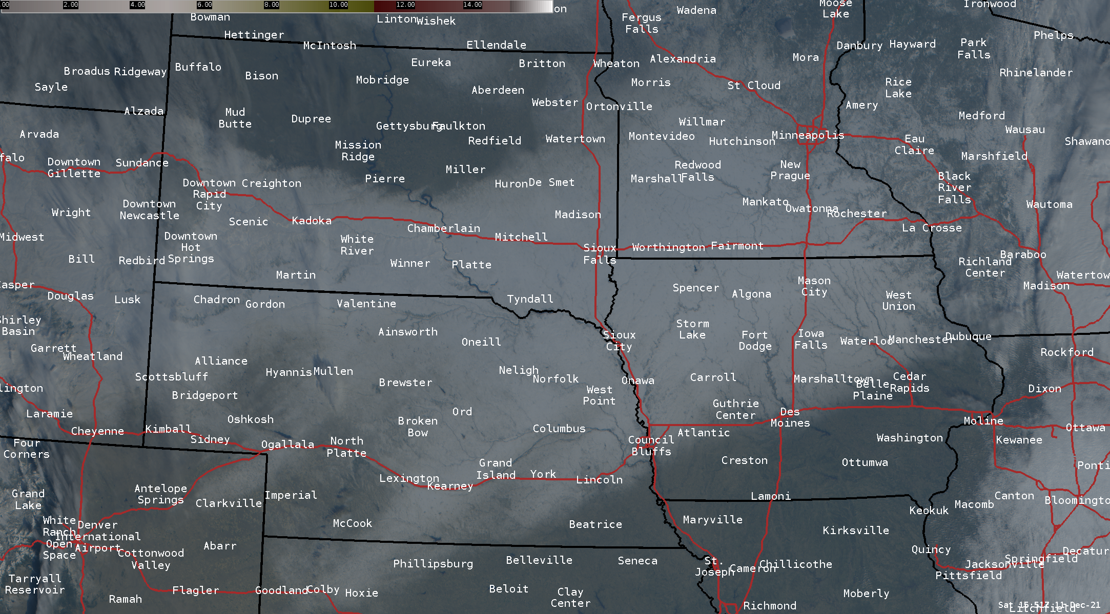
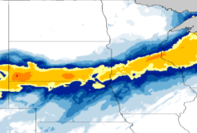
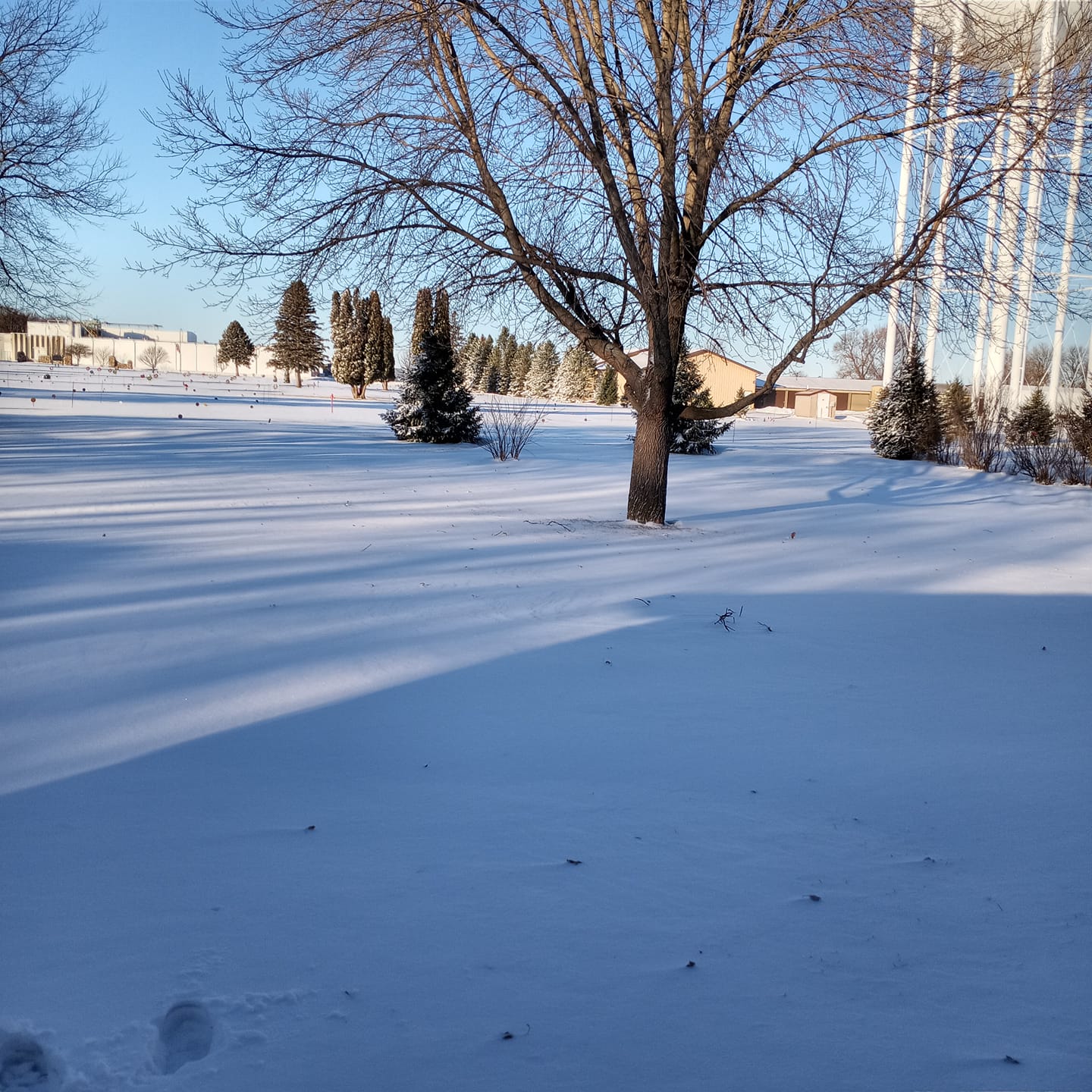
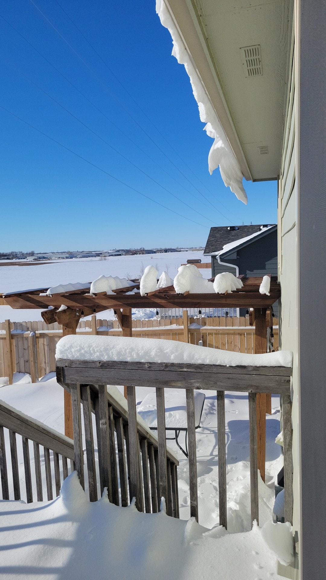
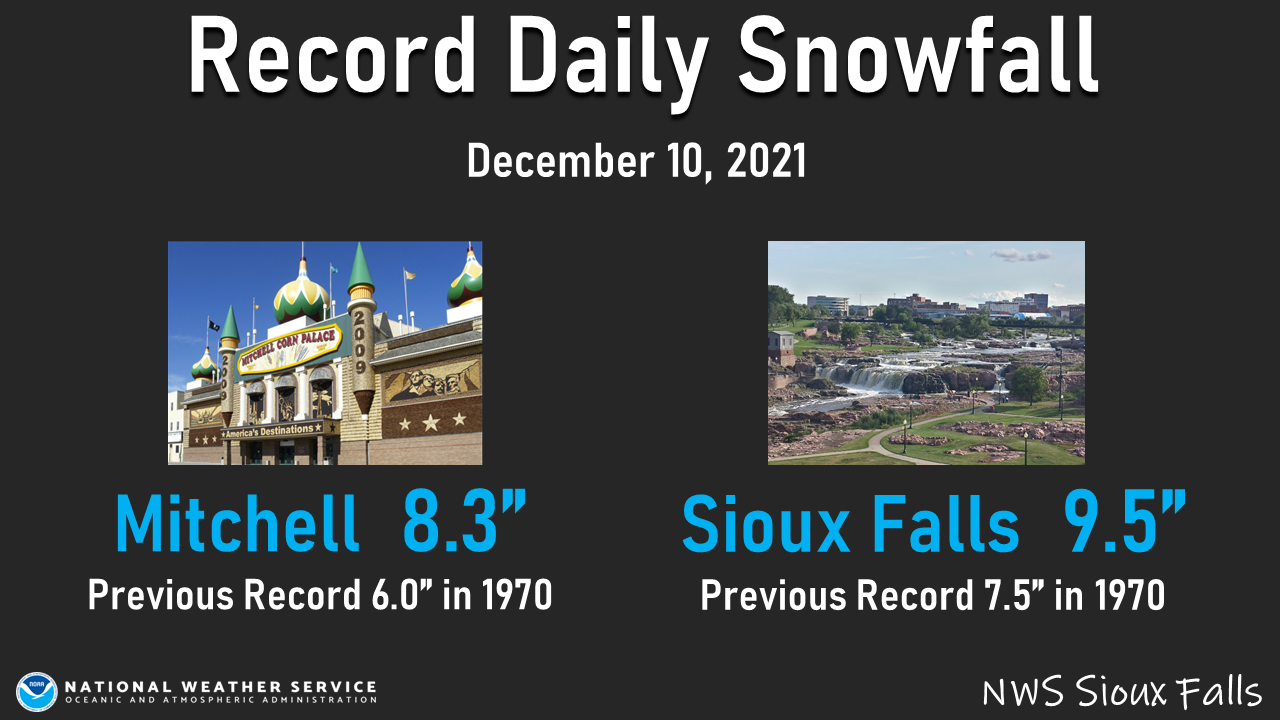
A strong winter storm brought widespread snow to the region on December 10, 2021. While light to moderate snow persisted much of the day, the region also experienced periods of heavy snow, as rates exceeded 1.0 inch per hour at times. Snowfall totals ranged anywhere from 2 inches to around foot of snow, with the highest amounts along the I-90 corridor in southeast South Dakota, and across portions of southwest Minnesota. A daily precipitation and snowfall record was set at both Mitchell and Sioux Falls during this event. |
 Fresh Snowfall across the region from the storm. Picture taken the following day on Saturday, December 11th. |
Snow/Ice
Here's a closer look at the snow accumulations from December 10, 2021.
 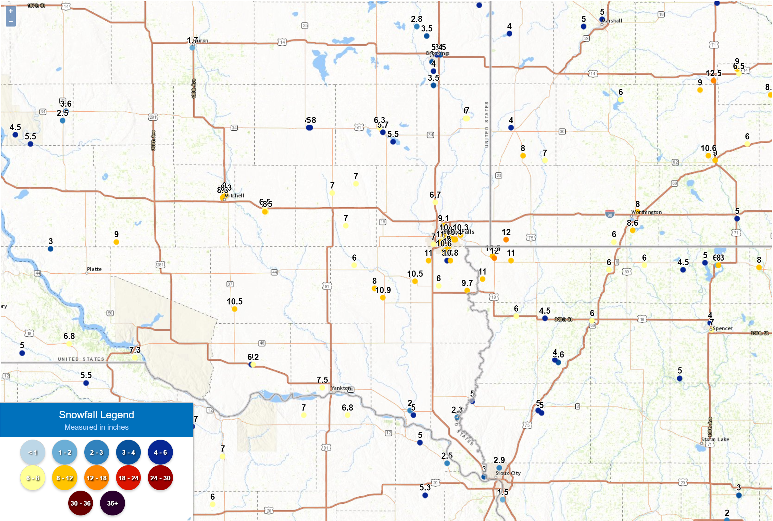 |
You can find specific snowfall amounts under the Storm Reports tab.
Photos & Video
 |
 |
 |
 |
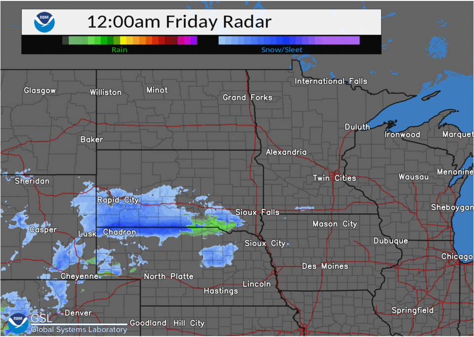
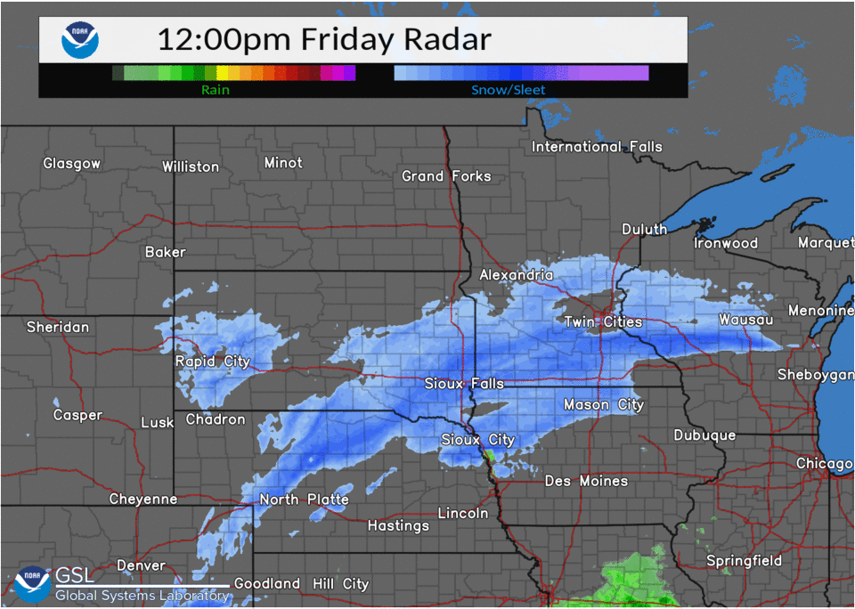
| 12 AM - 6 AM December 10: Watch the first band of snow develop south of I-90 and slowly move northward. |
6 AM - 12 PM December 10: As the first band of snow lifts north and weakens, a larger area of snow develops from south central South Dakota into southwestern Minnesota. |
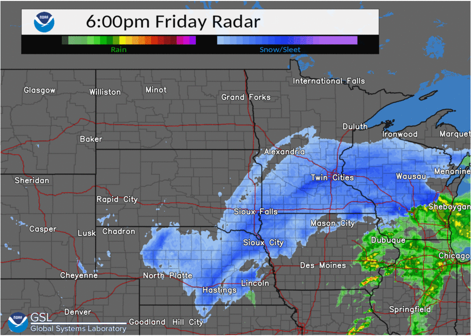
12 PM - 6 PM December 10: A large area of moderate to heavy snow remains nearly stationary across southeastern South Dakota into southern Minnesota. Some locations saw 6 or more inches of snow over this 6 hours. |
6 PM Dec 10 - 12 AM Dec 11: The area of snow moves east with the heaviest snow moving into southeastern Minnesota and Wisconsin. |
 |
 |
 |
 |
| Spencer, Iowa (Photo credit: Sherri Webster) |
Southwest Sioux Falls (Photo credit: Michelle Schnaidt) |
Luverne, Minnesota (Photo credit: Jordon-Emily Papik) |
A hawk near our office in Sioux Falls is watching the storm intensify on Friday morning. |
Daily Records
A daily precipitation and snowfall record was set at both Mitchell and Sioux Falls during this event.
 |
 |
| Daily Precipitation Records | Daily Snowfall Records |
Storm Reports
|
Location |
Amount |
Time/Date |
Provider |
|
Hills 0.2 NW |
12.0 in |
0700 AM 12/11 |
COCORAHS |
|
Larchwood |
12.0 in |
0730 AM 12/11 |
Public |
|
Gregory |
11.5 in |
0700 AM 12/11 |
HADS |
|
6 NNW Inwood |
11.0 in |
0807 AM 12/11 |
Public |
| Academy 2 NE | 11.0 in | 0700 AM 12/11 | COOP |
|
Lester |
11.0 in |
0850 AM 12/11 |
Public |
|
1 SE Tea |
11.0 in |
0905 AM 12/11 |
Trained Spotter |
|
2 SSW Sioux Falls |
11.0 in |
0909 AM 12/11 |
Public |
|
Hurley 0.2 S |
10.9 in |
0600 AM 12/11 |
COCORAHS |
|
Harrisburg 0.8 NNE |
10.8 in |
0700 AM 12/11 |
COCORAHS |
|
Sioux Falls 4.2 S |
10.6 in |
0700 AM 12/11 |
COCORAHS |
|
2.6 NW Windom |
10.6 in |
0800 AM 12/11 |
COOP |
|
Tripp |
10.5 in |
0804 AM 12/11 |
Public |
|
Sioux Falls 3.4 ESE |
10.4 in |
0700 AM 12/11 |
COCORAHS |
|
Sioux Falls 5.2 E |
10.3 in |
0700 AM 12/11 |
COCORAHS |
|
Sioux Falls |
10.0 in |
0730 AM 12/11 |
Public |
|
Canton |
9.7 in |
0800 AM 12/11 |
COOP |
|
Sioux Falls NWS |
9.5 in |
0600 AM 12/11 |
COOP |
| Dallas 8.8 S | 9.0 in | 0700 AM 12/11 | COCORAHS |
|
Worthington 4.0 S |
8.6 in |
0700 AM 12/11 |
COCORAHS |
| Hartford 6.4 S | 8.4 in | 0700 AM 12/11 | COCORAHS |
|
Mitchell 1.0 SE |
8.3 in |
0700 AM 12/11 |
COCORAHS |
|
Worthington 2 NNE |
8.0 in |
0700 AM 12/11 |
COOP |
|
Spencer |
8.0 in |
0700 AM 12/11 |
Public |
|
Alexandria |
8.0 in |
0800 AM 12/11 |
Public |
|
Spirit Lake |
8.0 in |
0800 AM 12/11 |
Public |
|
2 E Sioux Falls |
8.0 in |
0941 AM 12/11 |
Public |
| Stickney 3.8 SW | 8.0 in | 0700 AM 12/11 | COCORAHS |
| Burke 10.5 SSE | 7.8 in | 0700 AM 12/11 | COCORAHS |
|
Pickstown 4 SSW |
7.3 in |
0700 AM 12/11 |
COOP |
|
Edgerton 0.2 WSW |
7.0 in |
0600 AM 12/11 |
COCORAHS |
|
Montrose 5.8 NW |
7.0 in |
0700 AM 12/11 |
COCORAHS |
| Dimock 10.2 W | 7.0 in | 0700 AM 12/11 | COCORAHS |
| Parker 7.2 N | 7.0 in | 0700 AM 12/11 | COCORAHS |
|
Spencer |
7.0 in |
0700 AM 12/11 |
Public |
|
1 ENE Flandreau |
7.0 in |
0800 AM 12/11 |
Public |
|
Edgerton |
7.0 in |
0800 AM 12/11 |
Public |
|
Salem |
7.0 in |
0800 AM 12/11 |
Public |
|
Bonesteel 0.1 S |
6.8 in |
0800 AM 12/11 |
COCORAHS |
|
Renner 4.1 NW |
6.7 in |
0700 AM 12/11 |
COCORAHS |
|
Alexandria 0.4 WNW |
6.5 in |
0700 AM 12/11 |
COCORAHS |
|
0.6 E Spirit Lake |
6.3 in |
0700 AM 12/11 |
COOP |
|
Tyndall |
6.2 in |
0800 AM 12/11 |
COOP |
|
Sheldon |
6.0 in |
0700 AM 12/11 |
COOP |
|
Bigelow 1.8 NW |
6.0 in |
0800 AM 12/11 |
COCORAHS |
|
Sibley |
6.0 in |
0800 AM 12/11 |
COOP |
|
Madison 2SE |
5.7 in |
0900 AM 12/11 |
COOP |
|
Brookings 2 NE |
5.4 in |
0800 AM 12/11 |
COOP |
|
Allen |
5.3 in |
0900 AM 12/11 |
Public |
|
Vermillion 1.4 SE |
5.0 in |
0600 AM 12/11 |
COCORAHS |
|
Le Mars 1.0 E |
5.0 in |
0630 AM 12/11 |
COCORAHS |
|
Mitchell 0.9 SSE |
5.0 in |
0700 AM 12/11 |
COCORAHS |
|
Burke 10.5 SSE |
7.8 in |
0700 AM 12/11 |
COCORAHS |
|
Marshall |
5.0 in |
0800 AM 12/11 |
COOP |
|
Akron |
5.0 in |
0815 AM 12/11 |
Public |
|
Le Mars |
5.0 in |
0855 AM 12/11 |
Public |
|
Howard |
5.0 in |
0857 AM 12/11 |
Public |
|
1.1 NE Peterson |
5.0 in |
0900 AM 12/11 |
UCOOP |
|
4 N Lynd |
5.0 in |
1011 AM 12/11 |
Trained Spotter |
|
Lake Park 3.2 SSE |
4.5 in |
0700 AM 12/11 |
COCORAHS |
|
Hendricks 8.0 SE |
4.0 in |
0700 AM 12/11 |
COCORAHS |
|
Astoria 2.2 SSE |
4.0 in |
0700 AM 12/11 |
COCORAHS |
|
Orange City 0.4 WNW |
4.0 in |
0800 AM 12/11 |
COCORAHS |
|
Pipestone |
4.0 in |
0800 AM 12/11 |
COOP |
|
4 S Brookings |
4.0 in |
0900 AM 12/11 |
Public |
|
2 N Spencer |
4.0 in |
0945 AM 12/11 |
Public |
|
Orange City |
3.6 in |
0700 AM 12/11 |
COOP |
|
Brookings 6.5 NNW |
3.5 in |
0700 AM 12/11 |
COCORAHS |
|
Brookings 1.4 SW |
3.0 in |
0800 AM 12/11 |
COCORAHS |
|
Academy 2 NE |
11.0 in |
0900 AM 12/11 |
COOP |
|
Bruce 0.2 SSW |
2.8 in |
0700 AM 12/11 |
COCORAHS |
|
Elk Point 5.6 NNE |
2.3 in |
0900 AM 12/11 |
COCORAHS |
|
Huron 1.3 S |
1.7 in |
0600 AM 12/11 |
COCORAHS |
|
1 W Sergeant Bluff |
1.5 in |
1023 AM 12/11 |
Official NWS Obs |
| DeSmet | 1.5 in | 0700 AM 12/11 | COCORAHS |
 |
Media use of NWS Web News Stories is encouraged! Please acknowledge the NWS as the source of any news information accessed from this site. |
|


 Weather Story
 Weather Map
 Local Radar