Overview
|
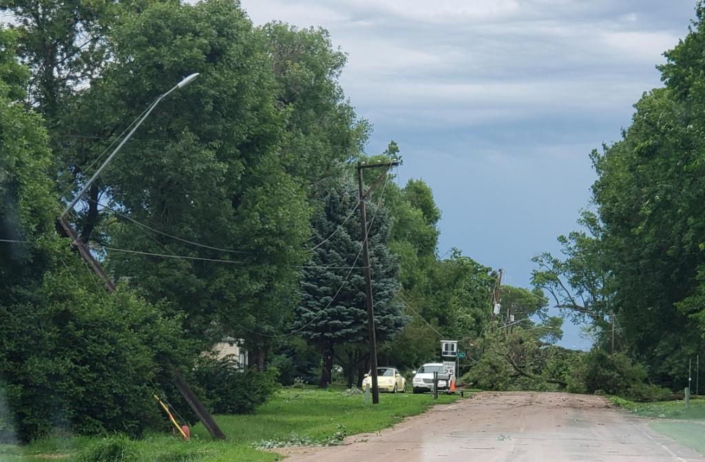
A cluster of thunderstorms evolved into a line and moved across southeastern South Dakota and into southwestern Minnesota & northwestern Iowa Saturday morning. While there was some small hail, damaging straight line winds were the main concern with these storms. Multiple reports of damage to large amounts of trees as well as some structural damage were caused by the severe winds. Some trees fell onto power lines causing power outages to numerous communities. |
Photo Credit: Macey Claeys |
Wind:
Widespread 60-70 mph winds were measured with this group of storms, with a couple sites measuring over 70 mph. The highest wind gusts recorded were 75 mph.
 |
 |
 |
 |
|
Canistota, SD Image Credit: BJ Stiefvater |
Canistota, SD Image Credit: BJ Stiefvater |
Spirit Lake, IA Image Credit: Mike Ehret |
Spirit Lake, IA Image Credit: Mike Ehret |
 |
 |
 |
 |
|
Canistota, SD Image Credit: BJ Stiefvater |
Canistota, SD Image Credit: BJ Stiefvater |
Worthington, MN Image Credit: Wade Anderson |
Worthington, MN Image Credit: Wade Anderson |
Radar
Radar Loop from 5 AM through 12 PM
Storm Reports

..TIME... ...EVENT... ...CITY LOCATION... ...LAT.LON...
..DATE... ....MAG.... ..COUNTY LOCATION..ST.. ...SOURCE....
..REMARKS..
0937 AM Tstm Wnd Gst 2 NNE Windom 43.90N 95.10W
07/20/2019 M75 MPH Cottonwood MN AWOS
AWOS station KMWM Windom Municipal Airport.
0733 AM Tstm Wnd Gst 2 SW Brookings 44.28N 96.82W
07/20/2019 M75 MPH Brookings SD AWOS
AWOS station KBKX Brookings Municipal
Airport.
0639 AM Tstm Wnd Gst 4 E Forestburg 44.01N 98.03W
07/20/2019 M75 MPH Sanborn SD Dept of Highways
SDDOT RWIS site.
0543 AM Tstm Wnd Gst 4 NNW Wolsey 44.46N 98.50W
07/20/2019 M75 MPH Beadle SD Dept of Highways
RWIS Station.
0759 AM Tstm Wnd Gst 3 W Dell Rapids 43.82N 96.78W
07/20/2019 M74 MPH Minnehaha SD Dept of Highways
SDDOT RWIS site.
0714 AM Tstm Wnd Gst 4 ENE Alexandria 43.67N 97.71W
07/20/2019 M74 MPH Hanson SD Dept of Highways
SDDOT RWIS site.
0638 AM Tstm Wnd Gst Iroquois 44.37N 97.85W
07/20/2019 M74 MPH Kingsbury SD Emergency Mngr
Trees down.
0754 AM Tstm Wnd Gst 3 SE Montrose 43.67N 97.15W
07/20/2019 M73 MPH McCook SD Dept of Highways
SDDOT RWIS site.
0654 AM Tstm Wnd Gst 5 W Plankinton 43.71N 98.58W
07/20/2019 M73 MPH Aurora SD Dept of Highways
SDDOT RWIS site.
0719 AM Tstm Wnd Gst 3 ENE Winfred 44.01N 97.31W
07/20/2019 M72 MPH Lake SD Trained Spotter
Measured on home weather station.
0554 AM Tstm Wnd Gst 10 E Hitchcock 44.63N 98.20W
07/20/2019 M72 MPH Beadle SD Trained Spotter
Received via social media.
0812 AM Tstm Wnd Gst 1 NNW Pipestone 44.01N 96.32W
07/20/2019 M71 MPH Pipestone MN Mesonet
Pipestone RAWS station. Time estimated from
radar.
0810 AM Tstm Wnd Gst 2 N Mitchell 43.77N 98.03W
07/20/2019 M70 MPH Davison SD ASOS
Peak wind gust recorded at the KMHE ASOS.
0759 AM Tstm Wnd Gst 10 SSW Aurora 44.16N 96.76W
07/20/2019 M70 MPH Moody SD Dept of Highways
SDDOT RWIS site.
0757 AM Tstm Wnd Gst Flandreau 44.05N 96.59W
07/20/2019 E70 MPH Moody SD CO-OP Observer
Estimated 60-70 mph.
0657 AM Tstm Wnd Gst 3 NNE Mitchell 43.77N 98.02W
07/20/2019 M70 MPH Davison SD AWOS
AWOS station KMHE Mitchell Municipal
Airport.
0943 AM Tstm Wnd Gst 4 WNW Spencer 43.17N 95.22W
07/20/2019 M66 MPH Clay IA ASOS
ASOS station KSPW Spencer Municipal Airport.
0816 AM Tstm Wnd Gst 3 NNW Sioux Falls 43.58N 96.75W
07/20/2019 M66 MPH Minnehaha SD ASOS
ASOS station KFSD Sioux Falls Airport.
0731 AM Tstm Wnd Gst 4 S Salem 43.67N 97.39W
07/20/2019 M66 MPH McCook SD Emergency Mngr
0607 AM Tstm Wnd Gst 2 NNW Huron 44.38N 98.23W
07/20/2019 M66 MPH Beadle SD ASOS
ASOS station KHON Huron Regional Airport.
0930 AM Tstm Wnd Gst 3 S Lakefield 43.64N 95.18W
07/20/2019 M65 MPH Jackson MN Dept of Highways
Lakefield RWIS station.
0900 AM Tstm Wnd Gst 2 NE Rushmore 43.64N 95.77W
07/20/2019 M65 MPH Nobles MN Dept of Highways
Mesonet station MN007 I-90 Mile Post 35.
0647 AM Tstm Wnd Gst 3 NNE Mitchell 43.77N 98.02W
07/20/2019 M64 MPH Davison SD AWOS
AWOS station KMHE Mitchell Municipal
Airport.
0910 AM Tstm Wnd Gst 3 NE Sibley 43.43N 95.71W
07/20/2019 M63 MPH Osceola IA Dept of Highways
Mesonet station RSYI4 2 NE Sibley.
0629 AM Tstm Wnd Gst 5 W Plankinton 43.71N 98.58W
07/20/2019 M63 MPH Aurora SD Dept of Highways
SDDOT RWIS site.
0824 AM Non-Tstm Wnd Gst 4 ENE Alexandria 43.67N 97.71W
07/20/2019 M62 MPH Hanson SD Dept of Highways
SDDOT RWIS site.
0604 AM Tstm Wnd Gst 2 NNW Huron 44.38N 98.23W
07/20/2019 M62 MPH Beadle SD ASOS
ASOS station KHON Huron Regional Airport.
0839 AM Non-Tstm Wnd Gst 3 W Dell Rapids 43.82N 96.78W
07/20/2019 M61 MPH Minnehaha SD Dept of Highways
SDDOT RWIS site.
0835 AM Tstm Wnd Gst 1 WSW Beaver Creek 43.61N 96.38W
07/20/2019 M61 MPH Rock MN Dept of Highways
Mesonet station MN006 Beaver Creek I-90 Mile
Post 4.
0950 AM Tstm Wnd Gst Dickens 43.13N 95.02W
07/20/2019 E60 MPH Clay IA Trained Spotter
0932 AM Tstm Wnd Gst 2 ESE Everly 43.15N 95.29W
07/20/2019 E60 MPH Clay IA Trained Spotter
Estimated 60 mph wind at Scharnberg Park.
Tree limbs breaking.
0700 AM Tstm Wnd Gst 6 NNW Plankinton 43.80N 98.53W
07/20/2019 M60 MPH Aurora SD Emergency Mngr
0625 AM Tstm Wnd Gst Plankinton 43.72N 98.49W
07/20/2019 E60 MPH Aurora SD Emergency Mngr
Estimated 50 to 60 mph. Time estimated based
on radar.
0835 AM Tstm Wnd Gst 1 NE Canton 43.31N 96.57W
07/20/2019 M59 MPH Lincoln SD Mesonet
Maximum wind gust measured at the Canton
mesonet site, site ID K7G9.
0645 AM Tstm Wnd Gst 3 NNE Mitchell 43.77N 98.02W
07/20/2019 M59 MPH Davison SD AWOS
AWOS station KMHE Mitchell Municipal
Airport.
0915 AM Tstm Wnd Gst 3 W Dovray 44.06N 95.60W
07/20/2019 M58 MPH Murray MN Dept of Highways
Mesonet station MN038 Dovray MN-30 Mile Post
49.
0913 AM Tstm Wnd Gst 3 W Dovray 44.06N 95.60W
07/20/2019 M58 MPH Murray MN Dept of Highways
RWIS station.
0807 AM Tstm Wnd Gst 3 NNW Sioux Falls 43.58N 96.75W
07/20/2019 M58 MPH Minnehaha SD ASOS
Corrects previous tstm wnd gst report from 3
NNW Sioux Falls. ASOS STATION KFSD JOE FOSS
FIELD.
0608 AM Tstm Wnd Gst 3 S Chamberlain 43.77N 99.32W
07/20/2019 M58 MPH Brule SD ASOS
ASOS station K9V9 Chamberlain Municipal
Airport.
0935 AM Tstm Wnd Gst 1 ENE Jackson 43.63N 94.97W
07/20/2019 M54 MPH Jackson MN AWOS
AWOS station KMJQ Jackson Airport.
0935 AM Tstm Wnd Gst 2 SW Le Mars 42.77N 96.20W
07/20/2019 M53 MPH Plymouth IA AWOS
AWOS station KLRJ Le Mars Airport.
1205 PM Hail 3 ENE Orleans 43.47N 95.05W
07/20/2019 E0.88 inch Dickinson IA Emergency Mngr
1042 AM Hail Brandon 43.59N 96.58W
07/20/2019 E0.70 inch Minnehaha SD Public
Pea to dime size hail in Brandon.
1030 AM Hail 3 N Sioux Falls 43.59N 96.73W
07/20/2019 M0.70 inch Minnehaha SD NWS Employee
Half inch to dime size hail at the NWS
office.
0603 AM Hail Westbrook 44.05N 95.44W
07/20/2019 E0.70 inch Cottonwood MN Trained Spotter
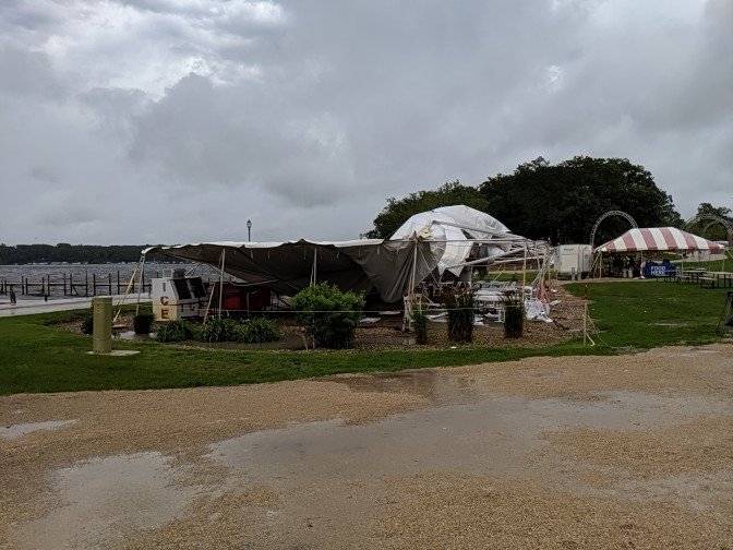
0935 AM Tstm Wnd Dmg Arnolds Park 43.37N 95.13W
07/20/2019 Dickinson IA Emergency Mngr
Large tents destroyed by Arnolds Park
Amusement Park. Time estimated from radar.
0934 AM Tstm Wnd Dmg Marcus 42.83N 95.81W
07/20/2019 Cherokee IA Trained Spotter
Five inch tree limbs broken.
0930 AM Tstm Wnd Dmg 7 ENE Melvin 43.32N 95.48W
07/20/2019 Osceola IA Trained Spotter
Six inch diameter tree branches down.
0915 AM Tstm Wnd Dmg Orange City 43.00N 96.05W
07/20/2019 Sioux IA CO-OP Observer
Large trees down throughout the town.
0906 AM Tstm Wnd Dmg Rock Valley 43.21N 96.30W
07/20/2019 Sioux IA Trained Spotter
Four inch diameter tree branch down.
0820 AM Tstm Wnd Dmg 3 E Sioux Falls 43.55N 96.66W
07/20/2019 Minnehaha SD Public
Wind split a large maple tree.
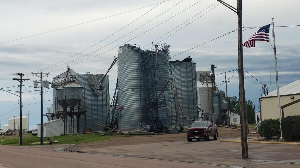
0738 AM Tstm Wnd Dmg Canistota 43.60N 97.29W
07/20/2019 McCook SD Emergency Mngr
Metal roof panels on small apartment
building ripped off. Time estimated from
radar.
0732 AM Tstm Wnd Dmg Canistota 43.60N 97.29W
07/20/2019 McCook SD Public
Heavy damage to grain elevator in town.
Report relayed via Twitter. Time estimated
from radar.
0723 AM Tstm Wnd Dmg 5 SSW Wentworth 43.94N 97.00W
07/20/2019 Lake SD Trained Spotter
Four boats lifted off their racks along the
south shore of Lake Madison. Time estimated
from radar.
0716 AM Tstm Wnd Dmg Stickney 43.59N 98.44W
07/20/2019 Aurora SD Emergency Mngr
Extensive tree damage in the town. A tree
fell onto power lines near the transformer,
causing power outages. Time estimated from
radar.
0715 AM Tstm Wnd Dmg Plankinton 43.72N 98.48W
07/20/2019 Aurora SD Emergency Mngr
5-6 inch diameter tree branches down in the
town.
0605 AM Tstm Wnd Dmg 7 NE Huron 44.46N 98.17W
07/20/2019 Beadle SD Public
Large Tree branches down. Estimated wind 70
mph. Time estimated based on radar.
0600 AM Tstm Wnd Dmg 7 NE Huron 44.46N 98.17W
07/20/2019 Beadle SD Public
0554 AM Tstm Wnd Dmg 15 NNE Kimball 43.95N 98.89W
07/20/2019 Jerauld SD Public
Big trees uprooted, large tree branches
down, corn and wheat laid over.
 |
Media use of NWS Web News Stories is encouraged! Please acknowledge the NWS as the source of any news information accessed from this site. |
|


 Weather Story
 Weather Map
 Local Radar