On August 21st, 2017, a total solar eclipse of the sun will occur across the continental United States. A total solar eclipse is a rare phenomenon due to its narrow path of totality and brevity (unlike total lunar eclipses which can cover a large area and last over an hour). The last total solar eclipse to occur across the continental United States was on February 26th, 1979, when totality moved across the Pacific northwest near the Canadian border during the morning hours of Mountain Standard and Pacific Standard time. The rest of the United States was treated to a partial solar eclipse, with 90 percent or more of the sun obscured here in the northern plains.
Below is the path of totality. Credit for this map goes to Ernie Wright, NASA/Goddard/SVS. The map is clickable to enlarge it. The eclipse begins in the morning, near 10:17 am PDT across northwest Oregon. It then moves southeastward into Nebraska and the northern Kansas City metro area right in the middle of the day, from 12:50 pm CDT to 1:10 pm CDT, then exits the U.S. via South Carolina near Charleston at 2:48 pm EDT. The map also shows how much the sun will be obscured outside the region of totality. For example, 90 percent of the sun will be obscured mid way between Sioux Falls and Brookings SD. Therefore the entire Sioux Falls forecast area will resemble twilight as the eclipse moves through. During the height of the eclipse, the sun at Sioux City will be about 93 percent obscured.
Continue reading below the map for more information including the ever important viewing safety.

Maps of the 14 states in which totality passes through:
Click Here for a link to the 14 states which totality passes through. Use the download feature below each state map to enlarge it. Visualization credit goes to Ernie Wright, NASA/Goddard/SVS. You may want to pay particular attention to Nebraska, which is the closest state to our area that totality will pass through. Be aware however that Nebraska has two time zones. If you travel to western Nebraska in the Panhandle region, they are on Mountain Daylight Time (MDT). Most of the state is in Central Daylight Time (CDT).
Looking at the eclipse through an oblique view:
This visualization by Ernie Wright shows an oblique view of the eclipse as it passes across the United States. Most maps show the eclipse as a circle. However in reality that is not the case. The oblique view takes into account terrain differences on our Earth as well as the edge of the moon with its own mountains and valleys. In particular, notice how the edge of the eclipse warps and deforms as it crosses over the terrain in the western United States.
***Important - Viewing safety information: ***
It is very important to have proper eye protection during the partial phase of the solar eclipse. Without eye protection, serious eye damage will result. If you are fortunate to view totality, the 2 1/2 minute portion of the solar eclipse in which the moon totally obscures the sun, then you can view the eclipse without eye protection. During totality, the corona and chromosphere around the sun are about as bright as the full moon. However for regions outside of totality, and/or when the solar eclipse is only partial, you will need eye protection. The National Weather Service cannot specifically endorse which companies sell proper eye protection. But what you want to look for is ISO 12312-2 international certification. Please visit this excellent safety site from NASA for further safety tips in viewing the solar eclipse.


 Weather Story
 Weather Map
 Local Radar
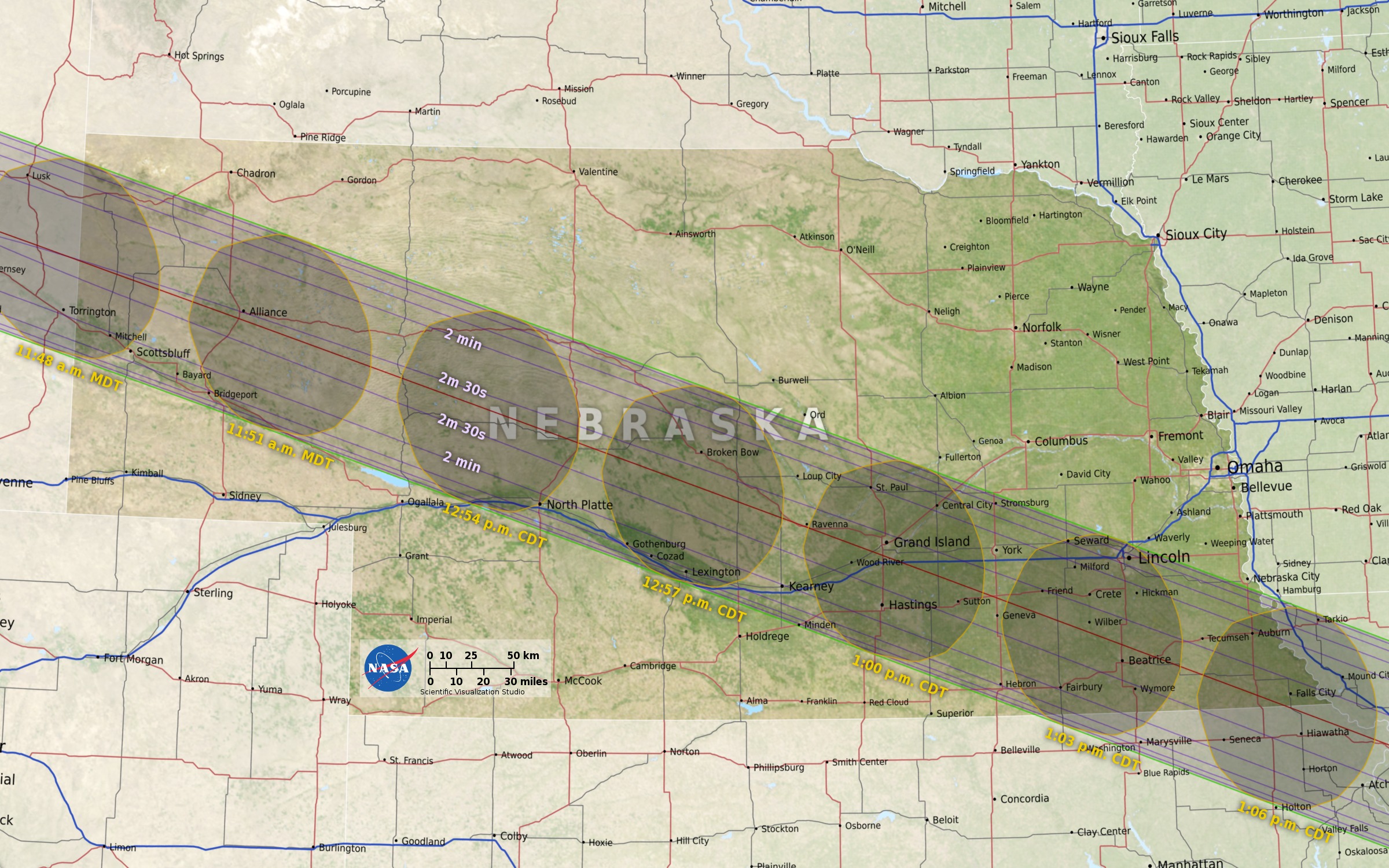