...June 15-16, 2008 Severe Weather Summary....
During the morning and afternoon hours of June 15th a large Mesoscale Convective System (MCS) developed across portions of Nebraska, Iowa, and Kansas and dropped southeast through the area. While insufficient instability kept the entire system from becoming severe over northern Missouri, there remained several pockets of severe weather in portions of central Kansas, northeastern Missouri, and southern Iowa on the tail ends of this convective system. In fact, winds between 60 to 75 mph were reported in portions of Schuyler, Sullivan, Grundy, and Nodaway counties during the late morning hours. Below is a picture of this system at its strongest point when it was producing damaging winds in Missouri and large hail in eastern Kansas.
 |
 |
| Local Radar Imagery Morning of June 15th | National Storm Reports (June 15, 2008) |
Large Hail in the Northland the Evening of June 15, 2008
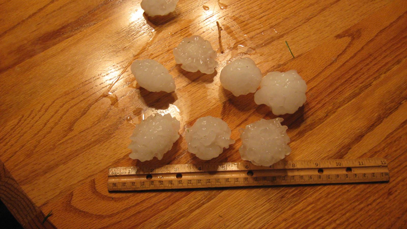
While much of the widespread thunderstorm activity took place during the daytime hours of the 15th. One very powerful supercell thunderstorm developed near Leavenworth, KS and tracked eastward near the Kansas City International Airport, and further east towards Kearney, Liberty, and Richmond. Since the moment it developed, this storm exhibited some of the classic signals of producing very large hail, including a very powerful updraft of air, high reflectivity values, and modest rotation in the mid-level of the storm. Some of the largest hail reported in this storm was around 2.75 inches near Leavenworth, KS and 2.25" near Kearney, MO. Due to the very strong upwards motion of the storm, large hail was actually thrown out of the storms and landed in places where the skies were still blue!
As you can see in the images below, the signature of hail can also be seen in radar imagery. A typical large hail indicator is called a "three body scatter spike" (TBSS) or the appearance of a beam of reflectivity away from the storm. In brief, simple terms, this is caused by the radar beam hitting the wet hail, scattering to the ground below, then scattering back upward, and finally being scattered once again by the hail aloft. The 3 scatterings illustrate the triple reflection, thus the term "three-body scatter spike". In cases of extremely large hail, this TBSS can be seen in many layers of the atmosphere as evident in the pictures below which show 4 different levels of the storm as sampled by radar.
For additional information on how large hail is produced, please visit the NWS Jetstream page on large hail, found here
 |
 |
| Radar Imagery ~8:50 PM | Radar Imagery ~9:35 PM (top and bottom) |
 |
 |
| Several Multi-Level Radar Views of Northland Hail Producing Supercell and TBSS | |
Hail Pictures
 |
 |
| Various Hail Pictures From Leavenworth, KS and Kearney, MO | |
|
Date/Time (GMT) |
County | Location | Report Type | |
| 06/15/2008 16:30 | Grundy, MO | 2 E Trenton | Tstm Wnd Dmg | |
| 06/15/2008 16:42 | Sullivan,MO | 5 E Galt | Tstm Wnd Dmg | |
| 06/15/2008 17:10 | Schuyler,MO | 3 N Lancaster | Tstm Wnd Dmg | |
| 06/15/2008 17:11 | Schuyler,MO | 3 Nw Glenwood | Wind Gust | 75 mph |
| 06/15/2008 17:14 | Schuyler,MO | 3 Nw Lancaster | Hail | 1" |
| 06/15/2008 17:37 | Henry,MO | 1 E Clinton | Wind Gust | 60 mph |
| 06/15/2008 18:37 | Henry,MO | 1 E Clinton | Wind Gust | 60 mph |
| 06/15/2008 18:41 | Henry,MO | 2 N Clinton | Hail | 0.88" |
| 06/15/2008 19:09 | Johnson,MO | 7 S Whiteman Afb | Hail | 0.75" |
| 06/15/2008 23:43 | Wyandotte,KS | 4 W Kansas City Ks | Hail | 0.75" |
| 06/16/2008 00:05 | Daviess,MO | 3 S Altamont | Hail | 1.75" |
| 06/16/2008 00:13 | Caldwell,MO | 7 Nw Kingston | Hail | 1" |
| 06/16/2008 00:17 | Caldwell,MO | Kingston | Hail | 0.88" |
| 06/16/2008 00:17 | Daviess,MO | 3 S Lock Springs | Hail | 2" |
| 06/16/2008 00:22 | Livingston,MO | Sampsel | Hail | 1.25" |
| 06/16/2008 00:26 | Caldwell,MO | Cowgill | Hail | 0.75" |
| 06/16/2008 01:47 | Leavenworth,KS | 2 W Leavenworth | Hail | 1.75" |
| 06/16/2008 01:50 | Leavenworth,KS | Ft Leavenworth | Hail | 2.75" |
| 06/16/2008 01:50 | Leavenworth,KS | Leavenworth | Hail | 2.75" |
| 06/16/2008 01:55 | Leavenworth,KS | 3 Ssw Leavenworth | Hail | 0.75" |
| 06/16/2008 01:55 | Leavenworth,KS | Leavenworth | Hail | 1" |
| 06/16/2008 01:56 | Leavenworth,KS | Ft Leavenworth | Hail | 1.75" |
| 06/16/2008 02:05 | Carroll,MO | 7 Sw Norborne | Hail | 0.75" |
| 06/16/2008 02:05 | Platte,MO | Kci Airport | Hail | 0.88" |
| 06/16/2008 02:08 | Platte,MO | Platte City | Hail | 0.88" |
| 06/16/2008 02:29 | Clay,MO | 4 Nw Liberty | Hail | 1.75" |
| 06/16/2008 02:35 | Clay,MO | E Kearney | Hail | 1.75" |
| 06/16/2008 02:35 | Clay,MO | Kearney | Hail | 2.25" |
| 06/16/2008 03:05 | Ray,MO | Richmond | Hail | 1" |
| 06/16/2008 03:10 | Ray,MO | Richmond | Hail | 1" |
| 06/16/2008 03:10 | Ray,MO | 4 Ene Richmond | Hail | 1.75" |
| 06/16/2008 03:15 | Carroll,MO | 7 Sw Norborne | Hail | 0.75" |


 Weather Story
 Weather Map
 Local Radar