... June 7th 2009 Severe Weather Summary...
A significant episode of severe weather, featuring extremely large and destructive hail and a few brief tornadoes, impacted portions of northwest and north central Missouri during the late afternoon and evening hours on June 7th. The setup for the event featured a slow moving warm front that was draped from far northwest Missouri southeastward into central Missouri. This front had been reinforced by a complex of thunderstorms that had impacted northern Missouri during the overnight and early morning hours prior, allowing abundant low level moisture to become pooled along the front. Strong daytime heating along and south of the front sent temperatures into the middle and upper 80s. With strong instability and moisture in place by late afternoon, conditions were ripe for rapid thunderstorm development as an upper level disturbance moving through Kansas provided the lift necessary for thunderstorms. However, it was the strong turning and increase in winds with height (known as wind shear) that set the stage for severe storms, specifically supercells.
While these extremely photogenic storms thankfully were not tornado producers, June 7th featured some of the most destructive hail ever observed across northern Missouri, with two separate storms producing softball and grapefruit size hail, leaving widespread destruction to trees, homes, and vehicles.
The Vortex 2 tornado research project, in addition to many dozens of storm chasers, provided invaluable information to the National Weather Service during this event. With an atmosphere and storm type conducive to tornado development, the June 7th case provided the Vortex 2 researchers an amazing data set to hopefully distinguish between those supercells that do produce tornadoes and those that do not.
The images below sample just a few of the most destructive storms, with captions describing them.
.png)
Visible satellite image taken at 715 PM CDT Jun 7 2009. Note the large thunderstorms already underway. You are seeing the storm tops, which are locally exceeding 50,000 feet in height! The little 'knobs' in the middle represent overshooting tops, where the storm updrafts are so violent (locally exceeding 100 mph), that they penetrate into the stratosphere.
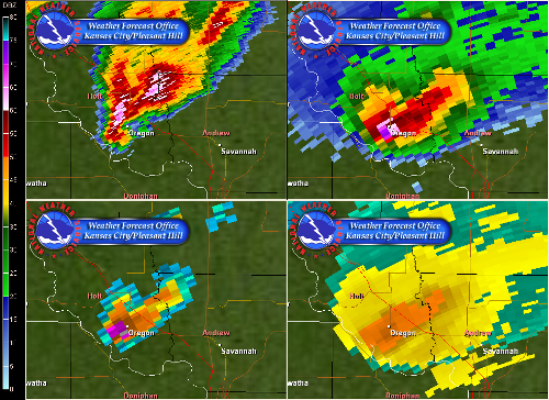
Four-panel radar image at the time softball size hail was falling in Oregon, MO, approx 645 PM CDT. Top left radar image shows a classic hook echo with a supercell storm, although a tornado was not observed at this time. Top right shows very high reflectivity (energy) core in the storm's mid levels, indicating potential for very large hail. Bottom left is the hail algorithm, indicating that 4" hail (grey) was likely with this storm. Bottom right is the echo tops, with radar indicating the storm tops nearing a whopping 60,000 feet!!

A vertical radar cross section gives a "slice" of the storm in the vertical, versus the usual bird's eye view. This image shows a prolific hail core, with a large volume of ice being sampled up to 40,000 feet tall! You can also infer the storm's anvil) in blue spreading across the top of the image, with the bulge near the center indicating the updraft and overshooting top.

At the time of this image, several reports of brief tornadoes were received in and around Maysville and Amity, MO. While the radar's velocity couplet (right) wasn't particularly impressive, the storm exhibited a very textbook supercell structure in its reflectivity appearance. Several photos at the bottom of this page show the beauty of this storm visually as the sun set.

This intense supercell thunderstorm produced widespread destructive hail just west of Gallatin Missouri just before 9 PM. Top two images show an amazing reflectivity core exceeding 75 dBZ, with the bottom left showing nearly 65 dBZ over 30,000 feet tall. These values, given the storm type, indicate the potential for large and very destructive hail. One person was injured after grape fruit size hail fell for over 10 minutes west of Gallatin, near Lake Viking, shattering glass.

Nighttime tornadoes are particular dangerous, and even more so when they are wrapped in rain and associated with high precipitation supercells. Here Doppler Radar saves the day showing a very strong rotational signature on the doppler velocity product (right), which the reflectivity structure lacks the classic "hook echo" seen in storms earlier in the evening. This is quite typical of high precipitation supercells, and why Doppler Radar is such an important tool at night. Shortly after this image, a tornado was spotted across southern Daviess county by spotters and the public. Survey team officials reported that little damage was produced by these brief tornado touchdowns, with the final ratings as EF-0 in nature.

Simon Brewster and Justin Drake document an amazing hail stone measuring 5.25" in diameter near Oregon, MO
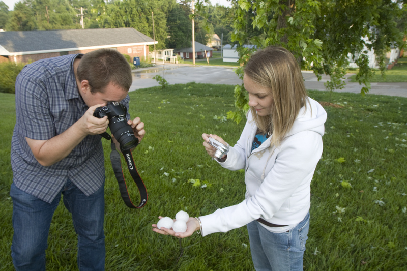
Vortex 2 researcher Karen Braun shows off over 2" diameter hail. Note the shredded foliage in the background.
Vortex 2 photogrammetry team captures this spectacular supercell storm near Maysville, MO at sunset.
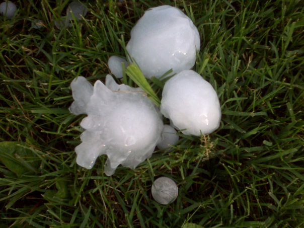
Jay Antle's photo compares some very large hail near Oregon, MO to a "quarter". Note that hail can be round or have very dangerous spikes.

Scott Weberpal captures an amazing lightning strike about 1/8 mile away.

Previous image zoomed in. Note the step leaders branching up from the ground!

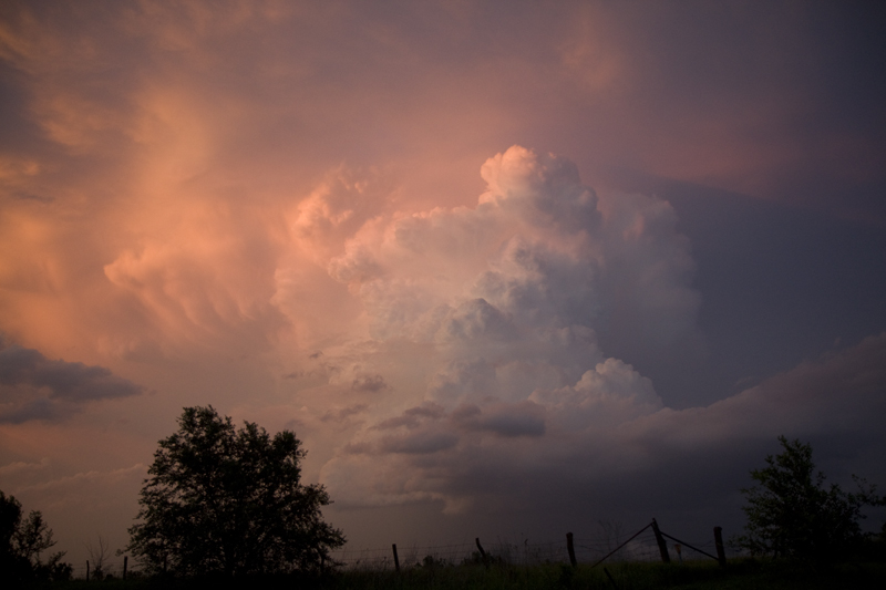
An amazing supercell updraft is photographed by Steve Polley along the Andrew and Holt county line.

Chaser Scott Tomlinson took this amazing lightning and wall cloud photograph Sunday evening near Chillicothe.

This amazing supercell photograph comes courtesy of storm chaser Scott Weberpal.
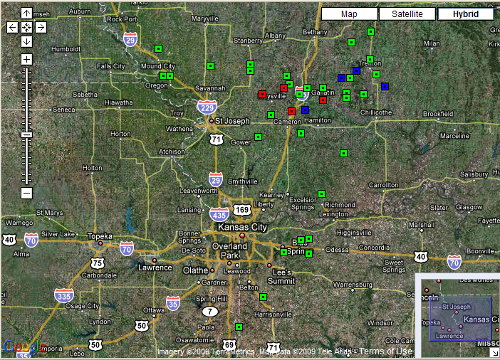
A map of storm reports received by the National Weather Service in Pleasant Hill. Green = large hail, blue = damaging wind gusts and red = tornadoes. The following is a list of storm reports.
4 tornado reports
32 hail reports
7 wind reports
SPC Storm Report Page for 090607
Tornado Reports
| Time (UTC) | Location | County | State | Lat | Lon | Comments |
| 0113 | AMITY | DEKALB | MO | 39.87 | -94.43 | TREE BRANCHES DOWN (EAX) |
| 0127 | 1 W WEATHERBY | DEKALB | MO | 39.91 | -94.26 | TORNADO RAIN WRAPPED (EAX) |
| 0344 | 3 NE CAMERON | CALDWELL | MO | 39.77 | -94.2 | SPOTTERS REPORTING POSSIBLE LARGE TORNADO (EAX) |
| 0405 | 5 S GALLATIN | DAVIESS | MO | 39.84 | -93.96 | REPORTED AT THE INTERSECTION OF 13 AND M HWYS (EAX) |
Hail Reports
| Time (UTC) | Size (inches) | Location | County | State | Lat | Lon | Comments |
| 2240 | 1.00 | DREXEL | CASS | MO | 38.48 | -94.61 | (EAX) |
| 2245 | 1.00 | LAKE LOTAWANA | JACKSON | MO | 38.93 | -94.26 | (EAX) |
| 2258 | 0.88 | DREXEL | CASS | MO | 38.48 | -94.61 | (EAX) |
| 2308 | 1.00 | 4 W HARRISONVILLE | CASS | MO | 38.66 | -94.42 | (EAX) |
| 2314 | 1.00 | 6 S BATES CITY | LAFAYETTE | MO | 38.92 | -94.07 | (EAX) |
| 2317 | 1.00 | OAK GROVE | JACKSON | MO | 39 | -94.13 | (EAX) |
| 2325 | 2.75 | MOUND CITY | HOLT | MO | 40.14 | -95.23 | (EAX) |
| 2330 | 2.00 | BATES CITY | LAFAYETTE | MO | 39.01 | -94.07 | (EAX) |
| 2331 | 2.75 | FOREST CITY | HOLT | MO | 39.98 | -95.19 | (EAX) |
| 2348 | 4.25 | OREGON | HOLT | MO | 39.98 | -95.14 | (EAX) |
| 2354 | 0.75 | RICHMOND | RAY | MO | 39.28 | -93.97 | (EAX) |
| 0005 | 1.00 | 7 N SAVANNAH | ANDREW | MO | 40.04 | -94.83 | INTERSECTION HWY 71 AND ROUTE A. (EAX) |
| 0007 | 1.00 | 5 S BRAYMER | RAY | MO | 39.52 | -93.8 | (EAX) |
| 0039 | 1.00 | LOCK SPRINGS | DAVIESS | MO | 39.85 | -93.78 | (EAX) |
| 0043 | 1.00 | KING CITY | GENTRY | MO | 40.05 | -94.52 | BEGAN 5 MINUTES AGO (EAX) |
| 0046 | 2.00 | 3 S KING CITY | DEKALB | MO | 40.01 | -94.52 | (EAX) |
| 0059 | 1.50 | 3 E JAMESPORT | GRUNDY | MO | 39.97 | -93.75 | (EAX) |
| 0106 | 0.75 | KING CITY | GENTRY | MO | 40.05 | -94.52 | (EAX) |
| 0106 | 2.00 | 10 NW TRENTON | GRUNDY | MO | 40.18 | -93.74 | (EAX) |
| 0122 | 2.50 | SPICKARD | GRUNDY | MO | 40.24 | -93.59 | (EAX) |
| 0129 | 1.00 | 6 E FAIRPORT | DEKALB | MO | 39.98 | -94.24 | (EAX) |
| 0147 | 2.00 | 6 NW WINSTON | DEKALB | MO | 39.93 | -94.22 | (EAX) |
| 0155 | 4.00 | 6 W GALLATIN | DAVIESS | MO | 39.91 | -94.08 | WINDOWS BREAKING (EAX) |
| 0210 | 1.75 | GALLATIN | DAVIESS | MO | 39.91 | -93.96 | (EAX) |
| 0231 | 1.50 | 2 N LOCK SPRINGS | DAVIESS | MO | 39.88 | -93.78 | (EAX) |
| 0248 | 2.50 | SPRING HILL | LIVINGSTON | MO | 39.87 | -93.65 | (EAX) |
| 0253 | 1.00 | 4 N PLATTSBURG | CLINTON | MO | 39.62 | -94.46 | (EAX) |
| 0253 | 1.00 | 14 N CHILLICOTHE | GRUNDY | MO | 39.99 | -93.55 | (EAX) |
| 0324 | 0.88 | OSBORN | DEKALB | MO | 39.75 | -94.36 | (EAX) |
| 0348 | 1.00 | WINSTON | DAVIESS | MO | 39.87 | -94.14 | (EAX) |
| 0354 | 0.75 | 5 W KINGSTON | CALDWELL | MO | 39.64 | -94.13 | (EAX) |
| 0444 | 0.75 | TRENTON | GRUNDY | MO | 40.08 | -93.6 | (EAX) |
Wind Reports
| Time (UTC) | Speed (mph) | Location | County | State | Lat | Lon | Comments |
| 0346 | UNK | KIDDER | CALDWELL | MO | 39.78 | -94.1 | TWO TREES DOWN IN CITY PARK. ONE TREE BROKEN IN HALF. (EAX) |
| 0359 | 60 | GALLATIN | DAVIESS | MO | 39.91 | -93.96 | (EAX) |
| 0404 | UNK | GALLATIN | DAVIESS | MO | 39.91 | -93.96 | POWERLINES DOWN AND ELEMENTARY SCHOOL DAMAGED IN WEST AND SOUTWHEST GALLATIN (EAX) |
| 0417 | UNK | KIDDER | CALDWELL | MO | 39.78 | -94.1 | TWO TREES DOWN IN CITY PARK. ONE TREE BROKEN IN HALF. (EAX) |
| 0426 | 80 | 1 W JAMESPORT | DAVIESS | MO | 39.97 | -93.82 | CAR BLOWN OFF HIGHWAY 6 AT THIS LOCATION (EAX) |
| 0440 | 65 | 7 SW TRENTON | GRUNDY | MO | 40.01 | -93.7 | (EAX) |
| 0444 | 75 | CHULA | LIVINGSTON | MO | 39.92 | -93.48 | (EAX) |
Page created by Evan Bookbinder, Senior Meteorologist.


 Weather Story
 Weather Map
 Local Radar