August 28, 2008 Severe Weather Summary
After a very hot and muggy day in which temperatures soared into the upper 80s to middle 90s, and dew points rose into the 70s across much of Missouri and Kansas, a weak cold front interacted with an upper level disturbance moving across the northern plains and pushed south into central and southern Missouri. The combination of the frontal boundary and the upper level energy provided enough lift to allow several strong to severe thunderstorms to form during the late afternoon and evening hours of Thursday, August 28th. Below is a preliminary map of storm reports that occurred with severe thunderstorm activity.
|
Local Storm Report Graphics |
|
 |
 |
| Kansas City Metropolitian Reports | Area Local Storm Reports |
Local Storm Reports
| Time (GMT) | County | City | Type | Magnitude | ||
|---|---|---|---|---|---|---|
| 08/28/2008 21:40 | Daviess,MO | Coffey | Wind Gust | 60 mph | ||
| 08/28/2008 21:52 | Andrew,MO | Avenue City | Hail | 0.88" | ||
| 08/28/2008 22:12 | Dekalb,MO | 5 W Stewartsville | Hail | 0.75" | ||
| 08/28/2008 22:15 | Grundy,MO | Trenton | Tstm Wnd Dmg | |||
| 08/28/2008 22:36 | Jackson,MO | 3 Sw Independence | Hail | 0.88" | ||
| 08/28/2008 22:40 | Jackson,MO | Kansas City | Hail | 0.88" | ||
| 08/28/2008 23:08 | Jackson,MO | Blue Springs | Hail | 1.0" | ||
| 08/28/2008 23:10 | Macon,MO | Macon | Tstm Wnd Dmg | |||
| 08/28/2008 23:10 | Jackson,MO | 6 N Lees Summit | Hail | 0.88" | ||
| 08/28/2008 23:12 | Jackson,MO | 2 Sw Blue Springs | Hail | 1.5" | ||
| 08/28/2008 23:15 | Linn,MO | 2 S New Boston | Tstm Wnd Dmg | |||
| 08/28/2008 23:30 | Johnson,KS | 1 W Edgerton | Hail | 1.75" | ||
| 08/28/2008 23:35 | Randolph,MO | Moberly | Tstm Wnd Dmg | |||
| 08/28/2008 23:45 | Miami,KS | 7 Nw Paola | Hail | 1.75" | ||
| 08/28/2008 23:50 | Lafayette,MO | 6 Sw Odessa | Tstm Wnd Dmg | |||
| 08/29/2008 00:10 | Johnson,MO | Holden | Tstm Wnd Dmg | |||
| 08/29/2008 00:10 | Macon,IL | Warrensburg | Tstm Wnd Dmg | |||
| 08/29/2008 00:45 | Pettis,MO | La Monte | Tstm Wnd Dmg | |||
| 08/29/2008 00:57 | Cass,MO | Creighton | Tstm Wnd Dmg | |||
| 08/29/2008 01:00 | Henry,MO | 3 E Creighton | Tstm Wnd Dmg | |||
| 08/29/2008 01:05 | Cooper,MO | Otterville | Tstm Wnd Dmg | |||
| 08/29/2008 01:15 | Cooper,MO | 3 S Prairie Home | Tstm Wnd Dmg | |||
Not only did these thunderstorms provide scattered large hail and damaging wind gusts, but also pockets of heavy rainfall. Much of this rain was a welcome site across the region (particularly across east central Kansas through central Missouri, which has seen little in the way of rainfall during the entire month of August). Below is a graphic of storm total rainfall for the event lasting from the late afternoon of August 28th through the morning of August 29th.
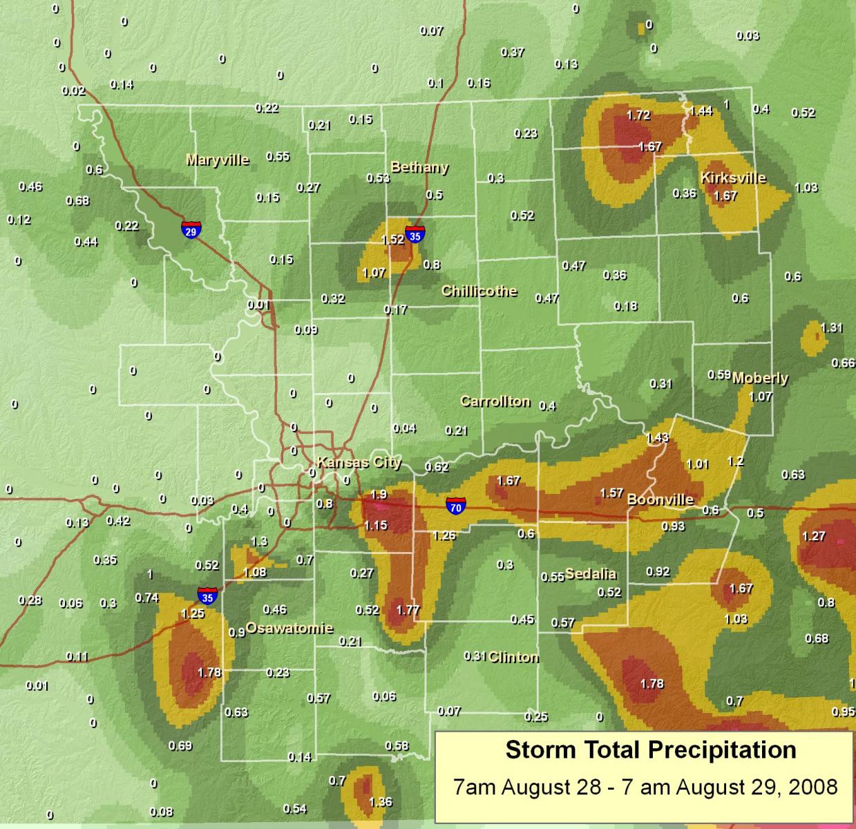
(click on image for larger version)
Wind Damage Pictures
Below are a few pictures of wind damage from around the area. As you can see in the picture, several large trees were blown over.
 |
 |
 |
 |


 Weather Story
 Weather Map
 Local Radar