Overview
Within a northwest flow pattern, extreme instability developed across the region. The greatest combination of instability and shear occurred during the afternoon and evening hours when supercell thunderstorms, producing several relatively weak tornadoes occurred on the southeast side of the Kansas City Metropolitan area. Several tornadoes occurred in Lee's Summit and just west-southwest of the Pleasant Hill Weather Forecast Office. The most significant of the three confirmed tornadoes occurred in Lee's Summit. This tornado did only minor structural damage The storms also produced widespread heavy rainfall and there were numerous reports of 3 to 5+ rainfall reports. This led to numerous areas of flash flooding.
Tornadoes:
Lee's Summit Tornado
JACKSON COUNTY
| Date |
July 1, 2015 |
| Time (Local) |
6:51 PM - 6:55 PM CDT |
| EF Rating |
EF-1 |
| Est. Peak Winds |
100 mph |
| Path Length |
0.9 mile |
| Max Width |
100 yards |
| Injuries/Deaths |
0 |
|
Summary:
This tornado formed near St. Luke's East Hospital and went southeast toward Lee's Summit North High School. The tornado did some superficial damage to a shopping center at the intersection of Sycamore and Douglas in Lee's Summit. The tornado then dissipated near Lee's Summit North High School after it destroyed a fireworks tent and knocked over a large trailer in the high school parking lot. The storm went on to produce a second brief and weak tornado near Lake Lotawana.
|
|
 |
 |
 |
 |
|
This photo was taken just north of HWY 150 and HWY 291 intersection, looking north toward the Summit Technology Campus and downtown Lee's Summit. The tornado lasted approximately 4 minutes, and did minor damage to structures and trees.
Photo: Chris Gitro
|
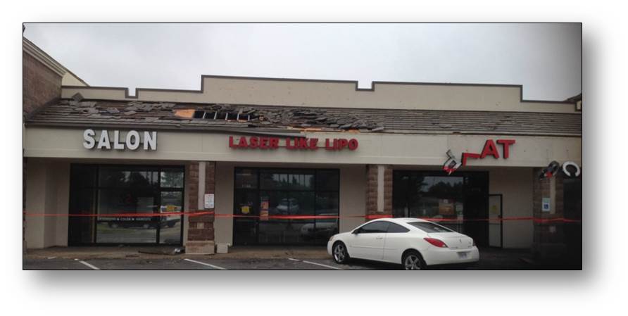
The shopping center at Douglas and Sycamore sustained mostly superficial damage when the tornado passed through the area. Winds were likely around 100 mph, but only lasted a short time.
Photo: NWS Storm Survey
|
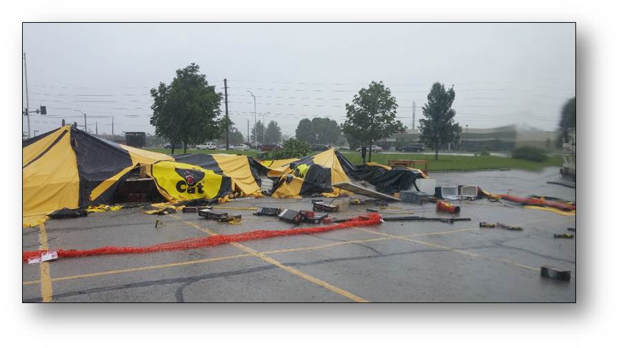
A fireworks booth was destroyed and a large nearby trailer was knocked over in the Lee's Summit North High School parking lot. The tornado dissipated shortly after it impacted the fireworks booth.
Photo: NWS Storm Survey
|
A photo of the supercell that produced the Lee's Summit tornado as seen from the HWY 7 and HWY 150 intersection, just north of Pleasant Hill.
Photo: Jared Leighton
|
|
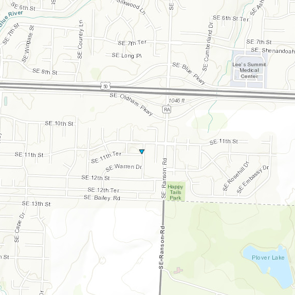
Lake Lotawana Tornado
JACKSON COUNTY
| Date |
July 1, 2015 |
| Time (Local) |
7:04 PM - 7:05 PM CDT |
| EF Rating |
EF-0 |
| Est. Peak Winds |
75 mph |
| Path Length |
0.2 miles |
| Max Width |
50 yards |
| Injuries/Deaths |
0 |
|
Summary:
This weak and brief tornado caused some minor tree damage in and around Lake Lotawana.
|
Track Map
|
|
|
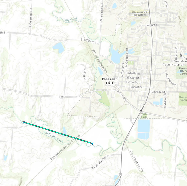
Pleasant Hill Tornado
CASS COUNTY
| Date |
July , 2015 |
| Time (Local) |
8:01 PM - 8:07 PM CDT |
| EF Rating |
EF-0 |
| Est. Peak Winds |
85 mph |
| Path Length |
1.4 miles |
| Max Width |
100 yards |
| Injuries/Deaths |
0 |
|
Summary:
This tornado formed just southwest of Pleasant Hill, and did some tree damage to areas outside the city.
|
Track Map
|
|
|
The Enhanced Fujita (EF) Scale classifies tornadoes into the following categories:
EF0
Weak
65-85 mph |
EF1
Moderate
86-110 mph |
EF2
Significant
111-135 mph |
EF3
Severe
136-165 mph |
EF4
Extreme
166-200 mph |
EF5
Catastrophic
200+ mph |
 |
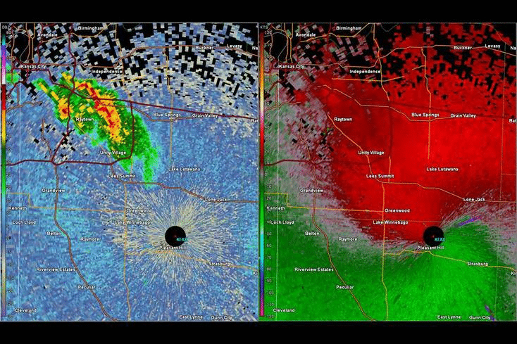
Radar:
Header
 |
|
Radar loop of the storms that formed in Kansas City.
Notice the tornado rotation as the storm moves into Lee's
Summit. A second tornado forms as the storm moves into
the Pleasant Hill area.
|


 Weather Story
 Weather Map
 Local Radar