
Heavy rain and widely scattered severe storms capable of large hail, damaging winds, and possibly a tornado are expected over portions of the central and southern Plains into the Lower Missouri Valley. Unseasonable warmth will continue for a few more days across the Midwest and Southeast where several daily record highs could fall. Read More >
Kansas City/Pleasant Hill, MO
Weather Forecast Office
Overview
|
A quickly moving clipper system pushed through the Central Plains overnight on the morning of Christmas Eve, bringing the area the first snow of the young winter season. Most of the snow fell early in the morning of December 24th, with the highest amounts across northern Missouri. Snow amounts tapered off to around an inch or two south of US Highway 36, with the Kansas City Metro getting between 1 and 2 inches. |
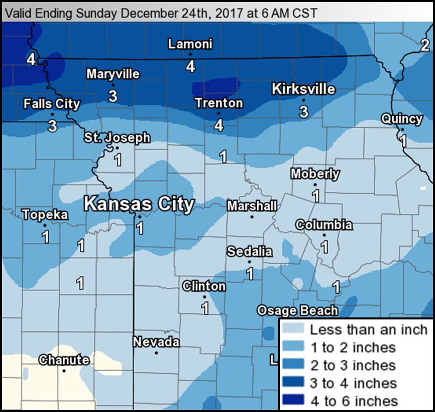 1 to 3 inches of snow fell across much of the area, with portions of northern Missouri getting over 4 inches. |
Photos & Video:
 |
 |
| The first snow of the year brought around 1.5" of snow across the Kansas City Metro. This image was taken south of Lee's Summit, near the Cass/Jackson County line. | The first snow of the year brought around 1.5" of snow across the Kansas City Metro. This image was taken south of Lee's Summit, near the Cass/Jackson County line. |
 |
Media use of NWS Web News Stories is encouraged! Please acknowledge the NWS as the source of any news information accessed from this site. |
|
Hazards
Decision Support
Situation Report
Local Weather Story
Submit Report
Storm Prediction Center
Weather Prediction Center
National Hurricane Center
Active Alerts
National Radar
Current Weather
Local Radar
Local Precipitation/Temperature
National Radar
Satellite
Observations
Observed Precipitation
Water and Air
Missouri Basin RFC
National Rivers
Local Rivers
Air Quality
Forecasts
Decision Support
Weather Story
Forecast Discussion
Local Fire Weather
National Fire Weather
Aviation Weather
FAA Center Weather
Graphical Forecasts
Weather Prediction Center
Space Weather Center
Climate
Climate Prediction Center
KC Records and Normals
KC Holiday Climate
KC Seasonal Rankings
National Climate Services
Climate Data Center
Drought
Local Storm Reports

US Dept of Commerce
National Oceanic and Atmospheric Administration
National Weather Service
Kansas City/Pleasant Hill, MO
1803 North 7 Highway
Pleasant Hill, MO 64080-9421
816-540-6132 (6021 automated weather)
Comments? Questions? Please Contact Us.


 Weather Story
 Weather Map
 Local Radar
 Follow us on X
 Follow us on Facebook
 Follow us on YouTube
 EAX RSS Feed