|
February 3rd/4th: The Ice Storm Cometh (Continued)
Precipitation, falling predominantly as fine particles freezing on contact, was virtually impossible to measure with today’s automated sensors. Gusty north winds didn’t help matters either. Officially, only a "trace" of liquid equivalent fell at Harlingen and McAllen, with a paltry 0.04 inches at Brownsville. In reality, more than a quarter inch of glaze accreted throughout much of Deep South Texas; some areas in Brownsville and nearby communities reported more than 1 inch of glaze before precipitation ended by mid morning on the 4th. Reports from CoCoRaHS told a more accurate story, with melted precipitation ranging from one tenth up to one half an inch. A summary of all storm reports received during and immediately after the icing is available here.
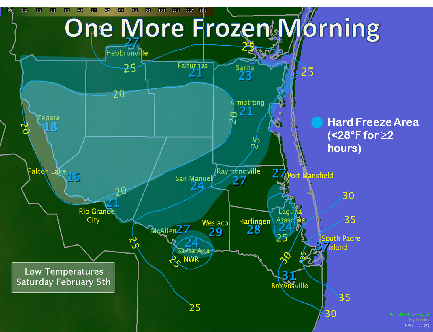
February 5th: One Last Frozen Morning
Afternoon sunshine on the 4th melted the ice, but the arctic air remained intact. With sunset, starry skies and nearly calm winds allowed for rapid radiational cooling, and temperatures quickly fell below freezing in all wind protected areas before midnight. The clear, calm conditions allowed temperatures to steadily fall into the upper teens and lower 20s in wind protected areas by daybreak from Hidalgo and western Willacy County north and west through the King Ranch, brush country, and Rio Grande Plains. Elsewhere, a light west wind, enhanced near the coast by differences between the colder land and relatively warmer Gulf of America, kept temperatures from falling much below freezing; in fact, temperatures remained in the upper 30s and lower 40s on South Padre Island. The map above shows the chilly story, and details on the duration of the freeze and hard freeze can be found here.
Epilogue
While many will compare the early February Winter Weather Outbreak of 2011 to prior events, one should remember that, like the proverbial snowflake, no two events are exactly the same. For sake of comparison, the 2011 event was most like one in early February, 1989. The time of year was nearly identical, the source region of the air mass, strength of the surface high, and initial positions were the same, and the relatively small spread and daytime and nighttime temperatures were very similar across the most populated section of the Rio Grande Valley. Light precipitation also fell, in the form of a cold rain, sleet, and freezing rain mix on some of the days. There were differences. Longtime residents of the Lower Valley do not recall such a glazing of ice. The prolonged period of freezing temperatures was less widespread in 1989. The duration of chilly temperatures was nearly double in 1989 than in 2011. Most importantly, potential impact on society was much greater in 2011, due to a much larger population using dozens, if not hundreds, more elevated roads.
Potential is the key word. Without the cooperation of partners in emergency management, public health and safety, transportation, utility, and media, the number of casualties could have been significantly higher in 2011. We thank those who literally helped save lives and protected property to meet our shared mission. Finally, we hope everyone learned a valuable lesson: Winter Weather, though rare, can strike Deep South Texas. Preparing for anything that Mother Nature sends our way, at any time, ensures a resilient community that can weather any storm.
Selected Links
|

