Tornado Event - October 25-26, 2010
Event Summary for Central Alabama
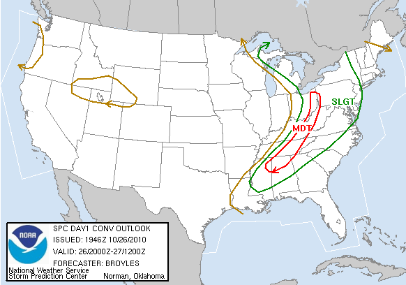
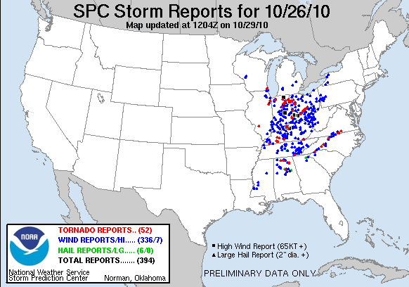
As part of a major extra-tropical system that rolled across the northern United States from Sunday, October 24th through Thursday, October 28th, a lingering cold front stalled across central Alabama producing several waves of severe weather. This extra-tropical system, which bottomed out at a record 955 millibars over Minnesota, produced extensive damage across the plains and midwest. Scattered thunderstorms affected central Alabama throughout the event producing numerous reports of wall clouds and funnel clouds, but only two areas received tornado damage through the event. Here is the summary of those tornado events:
|
Location/Clickable Detailed Summary Link
|
Damage Rating/Estimated Maximum Wind Speeds
|
Injuries/Fatalities
|
Damage Path Length/Width
|
Starting Point/Time
|
Ending Point/Time
|
|
|
EF-1
100-110 mph
|
None
|
12.1 miles
600 yards
|
34.1786/
-87.6088
205 am
|
34.2318/
-87.4076
218 am
|
|
|
EF-1
80-90 mph
|
None
|
4.3 miles
200 yards
|
33.6096/
-86.7093
910 pm
|
33.6352/
-86.6423
917 pm
|
Public Information Statement from October 25th | Local Storm Reports from October 24-25th, 2010
Public Information Statement from October 26th | Local Storm Reports from October 25-26th, 2010
Tornado Watch 711 was in effect from 135 am CDT until 9 am CDT on October 25th.
Tornado Watch 730 was in effect from 805 pm CDT until 2 am CDT on October 26th.
Severe Weather Episode Data