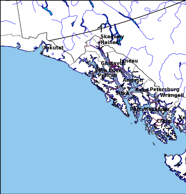
Flood Outlook
Current Conditions
|
|
|
|
|
Current Vis/IR Loop (click for loop)
|
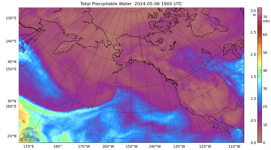
Total Precipitable Water Loop
|
|
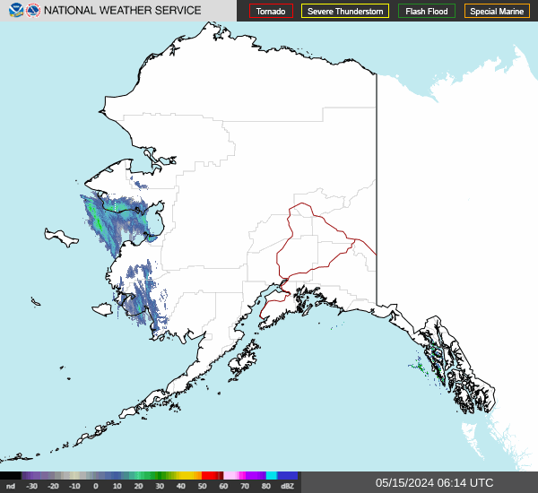
Alaska Mosaic Radar Loop
|
|
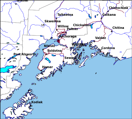
Kenai Radar Loop
|
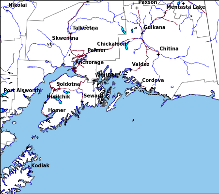
Middleton Radar Loop
|
Sitka Radar Radar Loop
|
|
Fairbanks Radar Loop
|
King Salmon Radar Loop
|
Bethel Radar Loop
|
|
Nome Radar Loop
|
Observed Precipitation
|
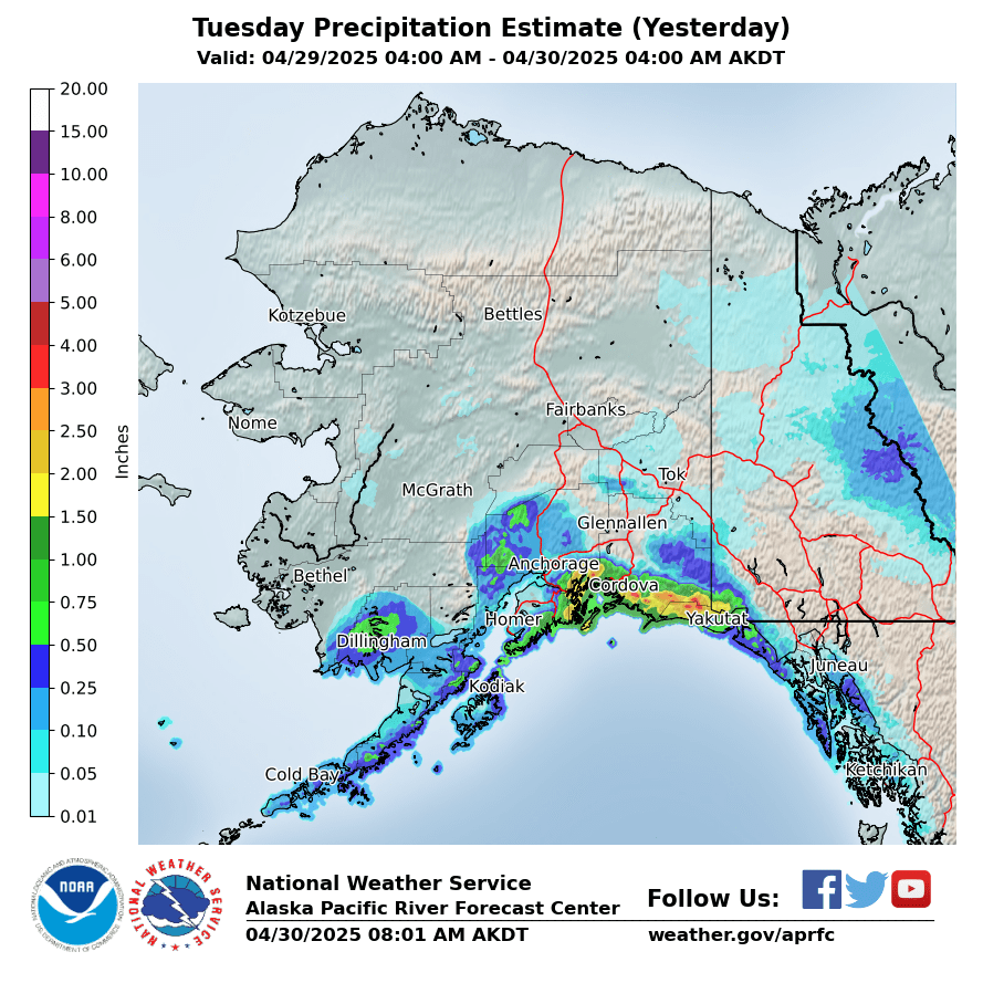
Yesterday
|
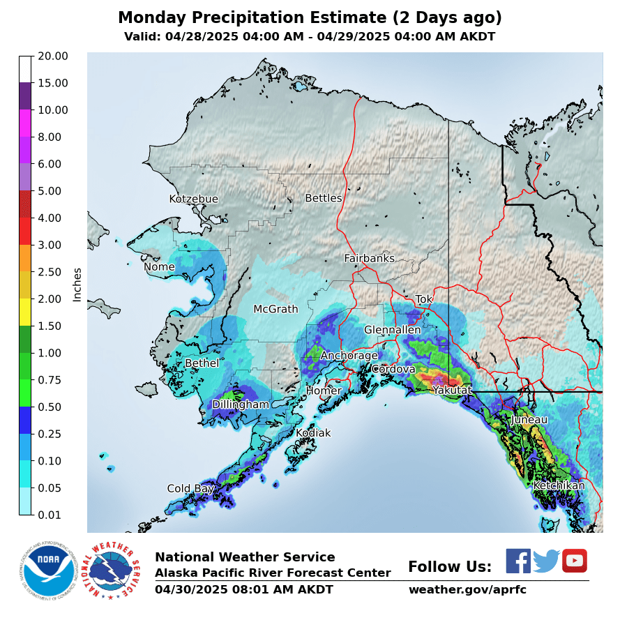
2 Days Ago
|
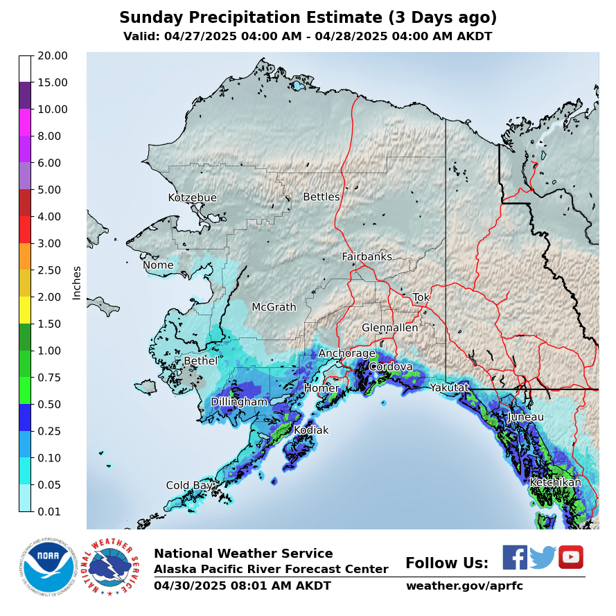
3 Days Ago
|
|
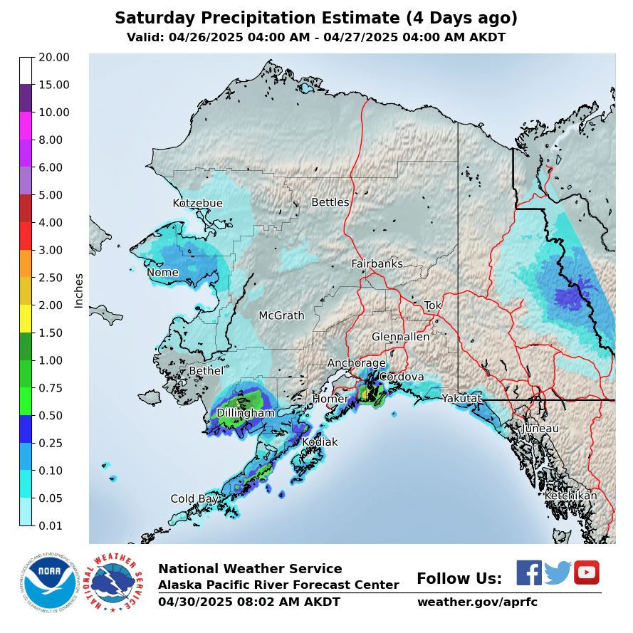
4 Days Ago
|
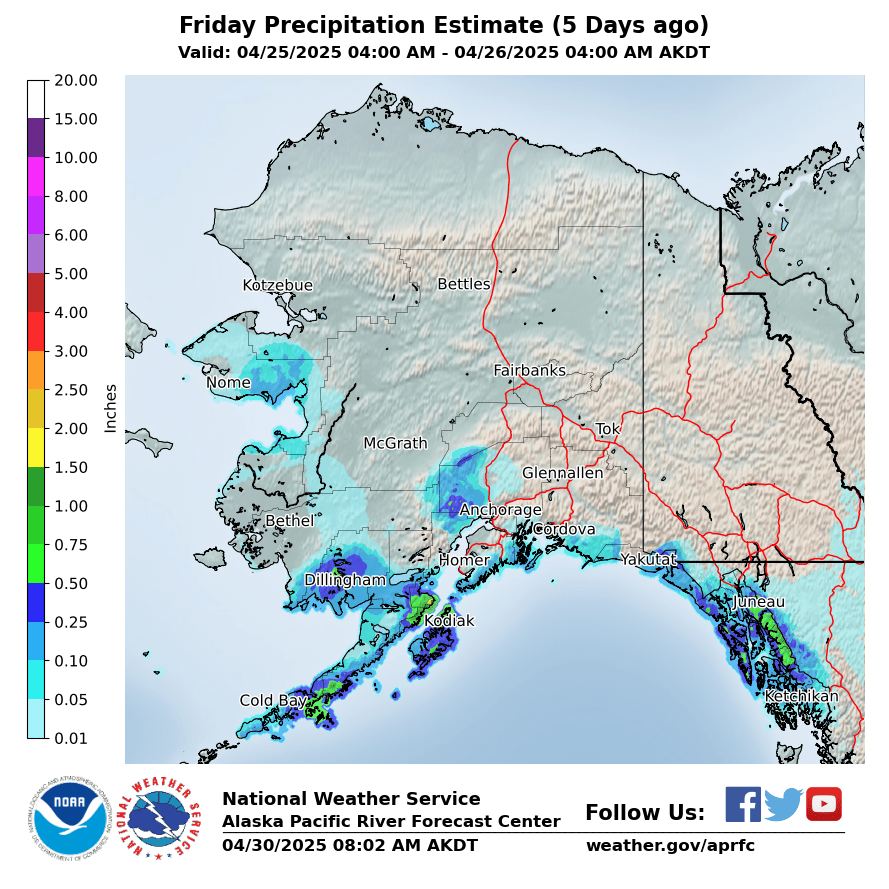
5 Days Ago
|
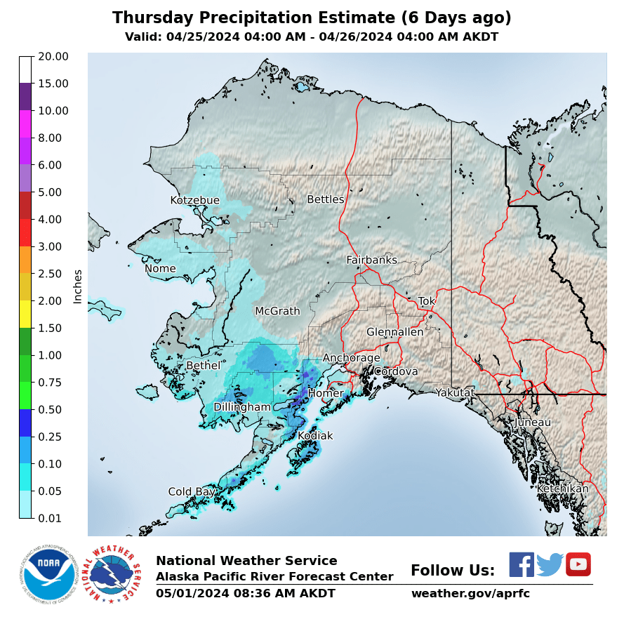
6 Days Ago
|
|
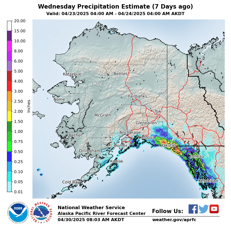
7 Days Ago
|
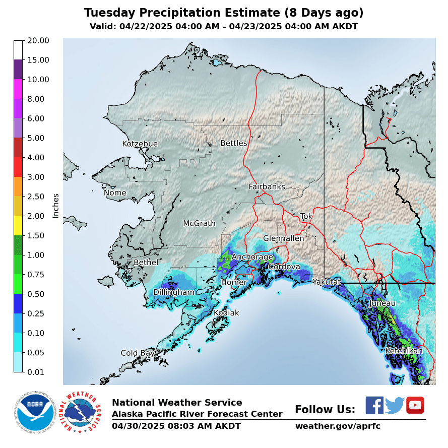
8 Days Ago
|
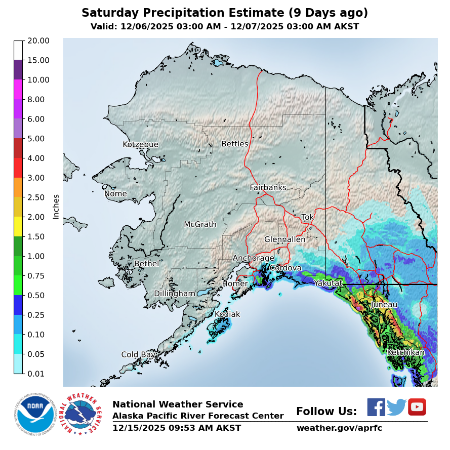
9 Days Ago
|
|
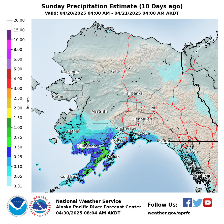
10 Days Ago
|
Forecasted Precipitation
|
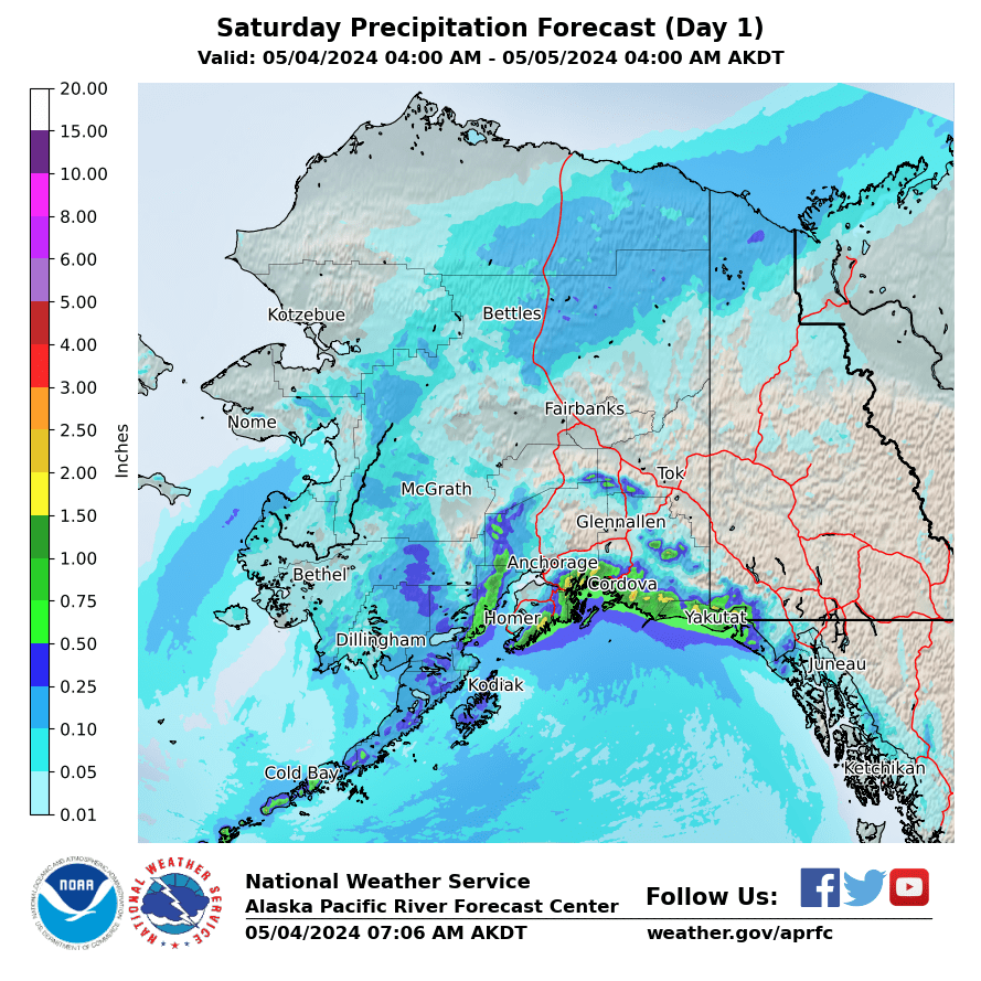
Day 1
|
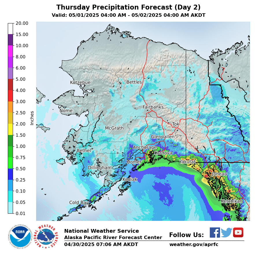
Day 2
|
Day 3
|
|
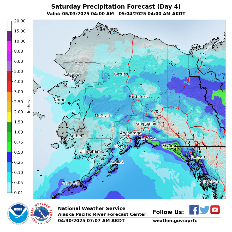
Day 4
|
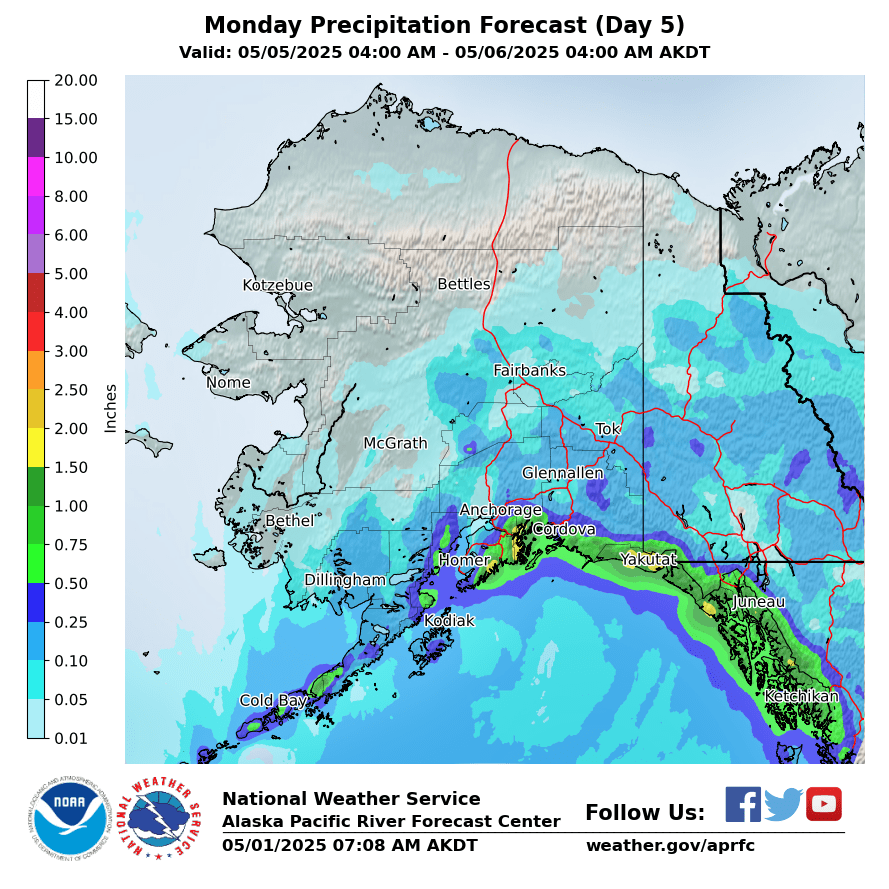
Day 5
|
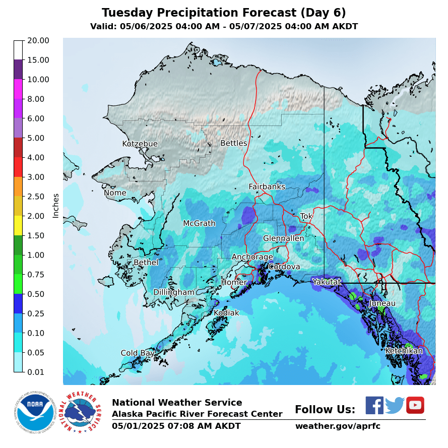
Day 6
|
|
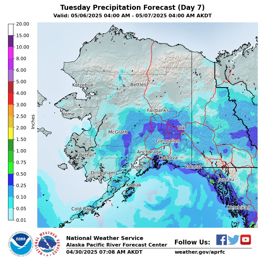
Day 7
|
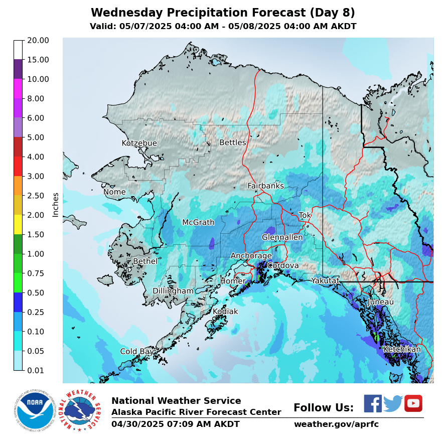
Day 8
|
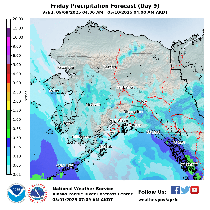
Day 9
|
|
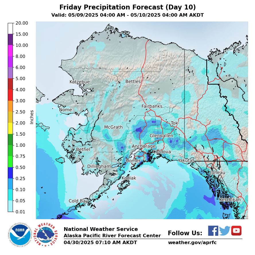
Day 10
|
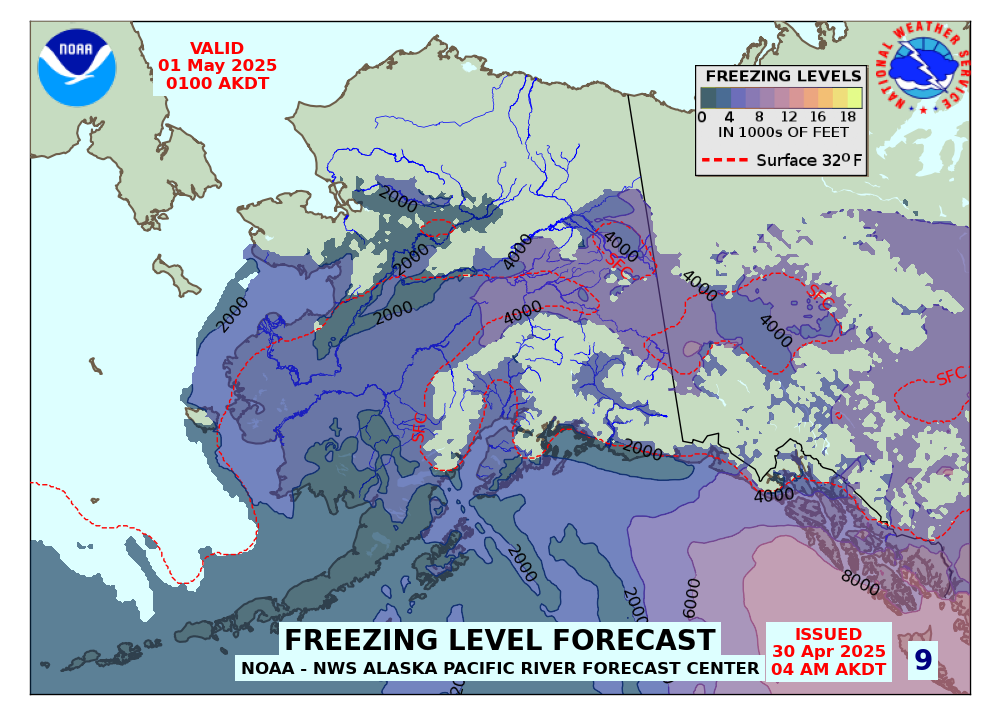
Forecasted Freezing Levels (click for Loop)
|
|
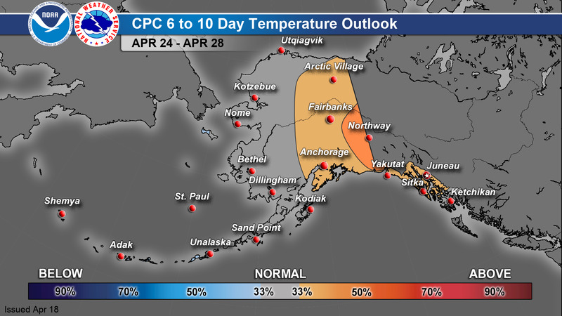
CPC 6-10 Day Outlook
|
Temperature
|
Precipitation
|
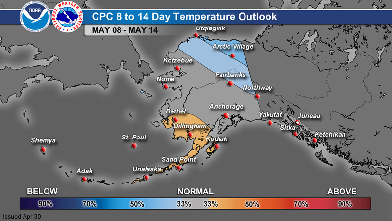
CPC 8-14 Day Outlook
|
Temperature
|
Precipitation
|
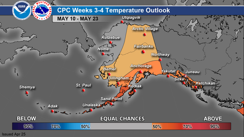
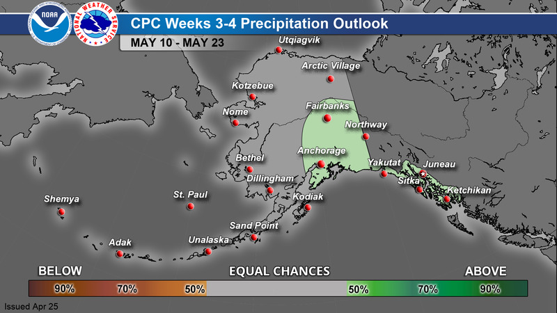
CPC Week 3-4 Outlook
|
Temperature
|
Precipitation
|
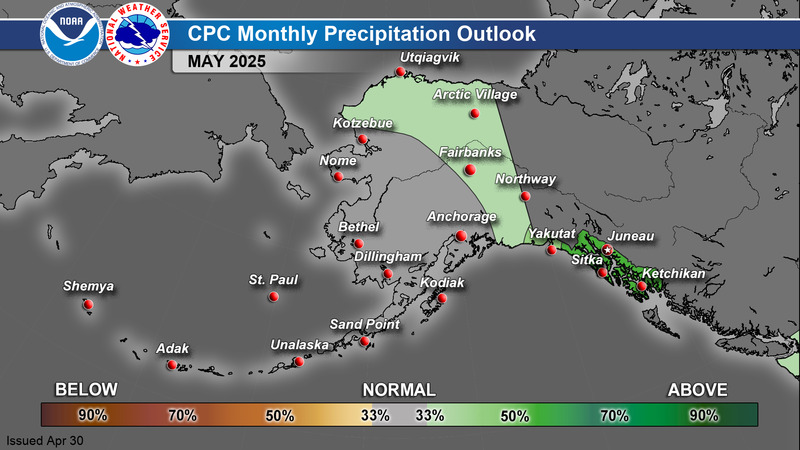
CPC 1 Month Outlook
|
Temperature
|
Precipitation
|
>
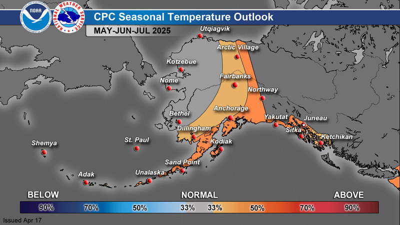
CPC 3 Month Outlook
|
Temperature
|
Precipitation
|
For additional climate outlook data, see: https://www.cpc.ncep.noaa.gov/
A Guide to Interpreting CPC Products: https://www.weather.gov/afc/GuideToInterpretCPCProducts
Alaska Drought Monitor
|
|
873
FXAK68 PAFC 101348
AFDAFC
Southcentral and Southwest Alaska Forecast Discussion
National Weather Service Anchorage AK
448 AM AKST Wed Dec 10 2025
.SHORT TERM FORECAST SOUTHCENTRAL ALASKA (Days 1 through 3)...
Key Messages:
- Gusty winds will continue through the extended forecast. Peak
timing for this next round is Wed afternoon through Thu morning.
Winds diminish for a brief period between Thu night through Fri
morning. Winds increase again Fri night with lower confidence
with how long those winds will remain elevated.
- Cold temperatures and wind chills are expected to persist until
at least the end of this week. A cold advisory is currently in
effect through Fri afternoon for the Copper River Basin and
through the Thompson Pass area.
- You can reduce your risk of hypothermia or frost bite by
protecting your skin from exposure and wearing appropriate
clothing while outdoors. Keep emergency supplies with you in
your home and while traveling whenever possible. Consider
wearing your cold weather gear while you are driving longer
distances through frigid temperatures. Know the signs of
hypothermia and check on others.
Discussion:
The forecast remains on track with a blocking ridge stubbornly
nestled over the Bering Sea. Northerly flow with a broad upper
trough remains across mainland Alaska and into the Panhandle and
Canada. Shortwave troughs will remain the key player in the timing
and amplification of the winds and cold air across Alaska,
including Southcentral.
Winds calmed down across Southcentral Alaska this past afternoon
including in the Matanuska Valley. Due to the lower winds and
another push of cold air from the north, low temperatures have
cooled into the negatives and single digits across Anchorage, the
Mat-Su Valley, and the Kenai Peninsula. The Copper River Basin
including Glennallen to McCarthy and Thompson Pass saw overnight
temperatures of minus 40F and colder. Due to these very cold
conditions, the Cold Weather Advisory has been extended until 4 PM
Friday and now includes Thompson Pass.
A weaker upper trough is moving into Southcentral this morning.
Expect wind speeds to increase later today through gap areas
including Valdez and around Kodiak Island. Since midnight, winds
have markedly increased through Seward and Whittier/Passage Canal.
The Matanuska Valley will also see increased winds, but these
will not nearly be as strong as the previous event. Gusts of 40 to
50 mph will be possible though. Anchorage and the Kenai Peninsula
will likely be breezy with gusts to 25 mph possible. These
effects will last through Thursday morning. Temperatures will
remain very cold as the Arctic air mass remains in place.
For Friday night, another stronger upper trough descends into
Southcentral. There are slight differences with the spatial
extent of this trough that would influence the resulting impacts.
With reasonably high confidence however, the wind speeds will once
again crank up throughout Southcentral. The Matanuska Valley
could see gusty winds with this trough. The Valdez gaps including
Valdez itself is another area that could see gusty winds. This
trough could potentially bring stronger and more prolonged winds
than what we are expected to experience later tonight into
tomorrow morning. Cloud cover will likely increase with this
event, so temperatures across the area could be relatively warmer,
especially in the Copper River Basin. However, another push of
cold air is expected Saturday and our weather regime is appearing
to stick around a bit longer.
Rux/JAR
&&
.SHORT TERM FORECAST SOUTHWEST/BERING SEA/ALEUTIANS (Days 1
through 3/This morning through Friday)...
A blocking ridge remains firmly entrenched over the Bering Sea,
maintaining dry and cold conditions over Southwest Alaska and the
eastern Bering Sea. Clear skies continue across much of Southwest
Alaska this morning, except for a low stratus deck and snow
flurries quickly moving south across the coastal areas of the
Kuskokwim Delta through early this morning as a shortwave digs
south across the region. Breezy northerly winds along the
Kuskokwim Delta coast have picked up early this morning and are
expected to continue through this morning as colder, drier air
works in from the north behind the passing shortwave. The Bering
ridge will continue to amplify throughout the day today, forcing
this trough and a reinforcing shot of Arctic air southward across
Southwest AK and the Alaska Peninsula. This will lead to a period
of strong and gusty northerly winds, especially through bays and
passes along the Alaska peninsula this morning through Thursday
morning. The strongest of these northerly winds are expected to
peak this afternoon and evening. The ridge will then quickly build
eastward toward Southwest AK this evening into Thursday, leading
to diminishing winds and falling temperatures.
Meanwhile, storm systems tracking to the west of the upper level
ridge will bring southerly winds and periods of rain to the far
western Aleutian Islands, including Shemya. One storm will flatten
the ridge as it tracks into the Arctic on Thursday. While most of
this will head eastward across northern AK, a trailing cold front
and weak short-wave will move into Southwest AK Thursday night
through Friday, likely bringing areas of light snow. There might
be just enough warm air moving off the Bering to produce rain or
freezing rain for portions of the Kuskokwim Delta coast, but
confidence in this is low. In any case, precipitation should be
brief and light. Cold air advection will bring another round of
winds Friday and into the weekend for portions of Southwest AK and
the Alaska Peninsula.
&&
.LONG TERM FORECAST (Days 4 through 7: Saturday through
Tuesday)...
This weekend, an expansive area of high pressure, stronger than
1040 mb at the surface, will be centered over the northern Bering
Sea and extend across Western/Interior Alaska and much of the rest
of the Bering Sea. This high pressure will aid in pushing Arctic
Air south across the state, causing a trough to dig across the
southern mainland into the Gulf of Alaska. This will bring similar
conditions to last weekend, with potential for another round of
high winds out of gaps and mountain passes, along with continued
cold temperatures and wind chills. A developing complex surface
low in the Gulf of Alaska could retrograde just enough early next
week to bring some light snow to the north Gulf coast and parts of
the Copper River Basin, but forecast confidence is low at this
time. Otherwise, the entire forecast area is expected to remain
dry, and this could continue to be the case for the next several
weeks as this general pattern of cold, dry weather looks to stick
around.
Quesada
&&
.AVIATION...
PANC...VFR conditions and light northerly winds will persist.
Northerly winds will increase to 10 to 15 kt this afternoon
through mid-day tomorrow before decreasing tomorrow night.
&&
$$
202
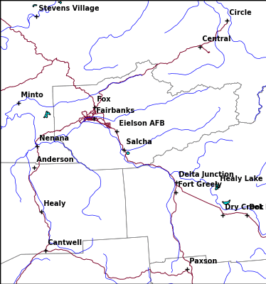
FXAK69 PAFG 101325
AFDAFG
Northern Alaska Forecast Discussion
National Weather Service Fairbanks AK
425 AM AKST Wed Dec 10 2025
.SYNOPSIS...
Cold weather continues across Interior Alaska, with many areas
seeing temperatures deeply in the negatives. The North Slope,
which is in the single digits above or below, will itself drop
into the negative teens by late this evening as colder air moves
in behind a cold front and snowfall ends. From Thursday through
the weekend as a low from Siberia moves along the Arctic coast
from west to east, it will bring widespread snowfall of at least
an inch with much warmer temperatures to most of Alaska north of
the AK Range. On the North Slope, winds will increase today and
especially tonight into tomorrow as the low approaches, which
could result in blowing snow and reduced visibilities at times,
especially where they combine with falling snow. Early next week,
very cold conditions settling in over the region could drop
temperatures into the -40s or -50s in much of Eastern Alaska, even
outside typical cold spots.
&&
.KEY WEATHER MESSAGES...
Central and Eastern Interior...
- Cold weather will continue across the Interior today before
warming Thursday and Friday. Cold valley locations will see lows
in the -30s and -40s, with the Upper Tanana Valley falling to
around -50F.
- Beginning on Thursday, another system will move into the area
and yield snow totals widely of around 1 to 3 inches through the
weekend, with higher totals of over 4 inches possible from the
north slopes of the Western AK Range to the White Mountains.
- Considerably warmer temperatures are likely on Friday with this
system, with highs widely rising into the positive single or
double digits.
- Early next week, much colder air is going to settle back into
the area, especially over the eastern half of the Interior,
which may allow for even colder temperatures to be possible.
West Coast and Western Interior...
- Cold weather with lows in the negative teens and 20s will
continue through tonight ahead of the next system.
- From Thursday through the weekend, much warmer temperatures are
expected, with increasing clouds and generally around 1-4 inches
of light snow. Highest totals are likely on the Chukchi Sea
coast and elevated parts of the southern Seward Peninsula.
North Slope and Brooks Range...
- Light snow will continue across the eastern North Slope today
before colder air is ushered in by a cold front in its wake by
late this evening. Accumulations will generally be light.
- A more robust wave of snow is expected from Thursday into the
weekend as a low moves along the Arctic coast. 2 to 4 inches of
snow are widely possible across the area. Higher totals are
possible in the Brooks Range and Arctic plains, mostly east of
the Dalton Highway. Portions of the eastern Brooks Range
southeast of Sagwon may receive between 6-8 inches of snow.
- As the low moves along the coast, widespread winds of 25 to 35
mph, with higher gusts, will shift from SW to W and could
combine with falling/fresh snow to blow and reduce visibilities.
&&
.FORECAST ANALYSIS AND DISCUSSION...
Broad ridging is in place across the Bering Sea and eastern
Siberia while troughing extends across northwestern Canada into
the high Arctic. A shortwave aloft is bringing some thin high
clouds to parts of the Interior but very little in the way of
precipitation as it shifts to the southeast. Areas could see
temporary increases in temperature as this narrow cloud band
traverses the area. A cold front which has brought periods of
light snow to the North Slope will exit the area by late this
morning, bringing in a return of colder air with lows in the
negative teens in its wake.
Early Thursday morning, a low pressure system will move north off
of Siberia and into the Chukchi Sea before moving eastward along
the Arctic Coast. As this happens, winds will initially pick up
from the southwest before turning west on the Chukchi Sea coast
and North Slope, where sustained winds may rise to 25 to 35 mph
(potentially 40 in spots), with higher gusts.
The system will also bring widespread snowfall to Alaska north of
the Alaska Range through Saturday evening. With respect to the
North Slope, most areas are likely to see at least 1-2 inches of
snow, but parts of the Arctic and Chukchi Sea coasts could see
amounts upwards of 3-4 inches. Areas in the Brooks Range and
Arctic plains near and especially east of the Dalton Highway could
see totals of 4-6 inches or more. On the Norton Sound coast, the
Seward Peninsula, and St. Lawrence Island, totals of around 1-4
inches are possible, with higher totals in the inland higher
terrain regions of the southern Seward Peninsula with upslope
flow. Totals will widely be at least 1 to 3 inches across most of
the Interior, but higher totals of 4-6 inches with potentially
high snow-to-liquid ratios will be possible from the northern
slopes of the Western Alaska Range northeast toward the White
Mountains, including most of Fairbanks North Star Borough. Where
falling snow combines with high winds, especially on the
Arctic/Chukchi Sea coasts, there could be visibility-restricting
blowing snow and perhaps blizzard conditions. As the low moves
east of the area, most falling snow should end by Saturday
morning, although winds on the eastern Arctic coast could persist
for longer than other areas, which could prolong any visibility
concerns.
&&
.EXTENDED FORECAST DAYS 4-7...
Through at least the first half of next week, the North Slope
could see multiple rounds of snow from a series of Arctic lows
moving either into the coast or into the Canadian Archipelago. As
these lows move into the area, winds on the eastern Arctic coast
could intermittently rise and lead to blowing snow. Elsewhere, a
strong high-pressure ridge aloft is expected to set up over the
Bering Sea, with cold troughing over northwestern Canada and a
very cold air mass extending from there into Eastern Alaska. With
the temperatures at 850 mb falling into the mid to lower -20s C,
surface temperatures from Mon December 15 through at least Wed
December 17 in much of Eastern and parts of Central Alaska could
reach into the -40s or even near -50F, even outside of typical
cold spots.
Coastal Hazard Potential Days 3 and 4...None
&&
.AFG WATCHES/WARNINGS/ADVISORIES...
AK...Cold Weather Advisory for AKZ835.
PK...Gale Warning for PKZ806-807-811-816-817-854-856-857.
Brisk Wind Advisory for PKZ810-812-850-853-858.
Brisk Wind Advisory for PKZ814.
Brisk Wind Advisory for PKZ815.
Heavy Freezing Spray Warning for PKZ817.
Heavy Freezing Spray Warning for PKZ851.
Gale Warning for PKZ851.
Brisk Wind Advisory for PKZ860.
Brisk Wind Advisory for PKZ861.
&&
$$
DS
600
FXAK67 PAJK 101758
AFDAJK
Southeast Alaska Forecast Discussion
National Weather Service Juneau AK
858 AM AKST Wed Dec 10 2025
.UPDATE...Update to the Aviation section to include the 18z TAF
issuance.
Forecast seems overall on track. Stronger winds the north. Snow
and lower clouds in the south. Any updates this morning will be to
refresh marine products and make small targeted edits.
&&
.SYNOPSIS...
Key Messages:
- Cold temperatures continue, with many areas seeing single
digits or sub zero temperatures. Dangerously cold wind chills
along White Pass.
- Partly cloudy and breezy conditions through the week, with
potential for more accumulating snow in the southern panhandle
next weekend.
&&
.SHORT TERM.../Through Tonight/...The very cold breezy
northeasterly outflow pattern that we have been experiencing
continues, keeping winds elevated, especially for the northern
half of the panhandle, which is still creating some dangerously
cold wind chills. Cold Weather Advisories are in effect for the
Gustavus / Glacier Bay zone until 9AM today & the Haines
Borough/Klukwan zone until 3PM today, & an Extreme Cold Warning is
in effect for the Municipality of Skagway until Noon today. The
weather station at White Pass reported wind chill values as low as
52 degrees below zero overnight. A weak low pressure center moves
to the south of the panhandle this afternoon, keeping cloud cover
increased for the south and keeping chances for light
precipitation in the forecast for the far southern panhandle into
this evening, keeping warmer air advected into that area. After
that low departs, the arctic boundary that we have been talking
about finally moves through the far southern panhandle behind it
tonight into tomorrow, decreasing temperatures & cloud cover.
.LONG TERM.../Thursday through Sunday/...Only minor changes were
made to the long term forecast, mainly adjusting outflow wind
speeds and pushing the potential snow for next weekend back a day.
By Thursday morning, the low moving south of the panhandle will
have moved inland into BC and dissipated, with strong outflow
winds keeping any developing showers offshore until Saturday
morning. This means that the panhandle will remain dry through the
rest of the week, with low PoPs and partly cloudy skies
dominating the forecast. A small surface ridge developing on
Friday is expected to make that day the most clear and the least
windy. Precipitation is expected to return to the forecast
Saturday morning as a low jumps into the southern gulf and sends a
front northward into the panhandle. Uncertainty still remains in
how far this front will make it through the panhandle, as
persisting outflow winds will attempt to force the front to stay
more southern. With colder temperatures remaining through the long
term forecast, precipitation will most likely fall as snow.
Active weather looks to remain into early next week.
The main concerns for the long term remain the temperatures and
winds. The arctic boundary continues to extend southward through
the week, keeping below freezing temperatures through the extended
forecast. Daytime highs will struggle to reach into the 20s for
many locations in the northern and central panhandle, and into the
30s for the southern panhandle. Overnight lows during the week
will mostly stay in the single digits up north and in the 10s down
south, slightly increasing through the weekend as the next system
moves in, though still staying below freezing. An extreme cold
warning for Skagway, primarily along the Klondike Highway, is
still active through noon Wednesday for extremely cold
temperatures as low as 45 degrees below. Cold weather advisories
for the Haines Borough and Gustavus have been issued through 9 AM
Wednesday for wind chills as low as 15 degrees below, primarily
once the sun sets. Strong outflow also persists through the week,
with 20 to 35 kt winds and pockets of gales blowing through the
inner channels and funneling out into the coastal waters of the
gulf. The strongest winds will remain in the northern panhandle,
particularly down Lynn Canal and Stephens Passage and out of Cross
Sound, with gaps along the gulf coast serving as outlets for
strong winds to funnel through. There will be a brief decrease in
wind speeds on Friday, though Lynn Canal will still stay above 20
kts before outflow ramps up even stronger than before going into
the weekend. Strong gales are expected to spread through a
majority of the inner channels, with strongest winds remaining in
those hot spots in the northern panhandle. Freezing spray will
remain an issue in the inner channels and along the NE gulf coast
with these elevated winds, which could become heavy at times.
&&
.AVIATION...For the Northern panhandle, VFR conditions continue
through the TAF period. Wind speeds will be strongest in the Lynn
Canal area with airport reporting speeds around 15 to 25 kts with
gusts above 30 kts.
For the Southern panhandle, a front from a weakening low south of
the panhandle is bringing a band of snow over most location. The
light snow has lowered VIS to 2 to 4 SM with CIGs AoB 3000 ft and
gusty winds up to 20 kts. As the front moves out of the area
through midday, skies will clear out and TAF sites will become
solidly VFR for the night. Sites that are typically more
susceptible to winds will remain impacted by the outflow at around
10 kts with the occasional gust.
&&
.MARINE...
Inside Waters: Generally, the northeasterly outflow pattern
continues for the next several days, keeping up to around 40 kt
gale-force sustained winds for the northern 2/3 of the Inner
Channels with the strongest winds the farther north that you go,
with Northern Lynn Canal experiencing the strongest winds. These
winds will also be accompanied by fully-developed seas up to
around 17 ft with generally the highest waves the more northward
you go, due to the long-fetch of these strong winds. Additionally,
mainly due to air temperatures being so cold, up to heavy
freezing spray is also likely.
Outside Waters: Generally, northeasterly outflow winds up to 35 kt
gale-force are in store for the northeastern gulf through
Thursday. For Friday, the pressure gradient relaxes & winds
decrease. Finally, those winds ramp-up, again, up to around 40-45
kt gales for the same area for the weekend as the pressure
gradient tightens & northerly outflow intensifies, once again.
Significant wave heights top out at around 14 ft today & top out
at around 22 ft for the weekend. Some freezing spray is possible
for the northeastern gulf.
&&
.AJK WATCHES/WARNINGS/ADVISORIES...
PUBLIC...Extreme Cold Warning until noon AKST today for AKZ318.
Strong Wind from 6 PM AKST this evening through late tonight for
AKZ318.
Cold Weather Advisory until 3 PM AKST this afternoon for AKZ319.
Cold Weather Advisory until 9 AM AKST this morning for AKZ320.
MARINE...Heavy Freezing Spray Warning for PKZ011>013-031-053.
Gale Warning for PKZ012-013-031-651.
Small Craft Advisory for PKZ011-021-022-032>034-053-641>644-652-
661>664-671-672.
&&
$$
SHORT TERM...JLC
LONG TERM...ZTK
AVIATION...GJS/ZTK
MARINE...JLC
Visit us at http://www.weather.gov/Juneau