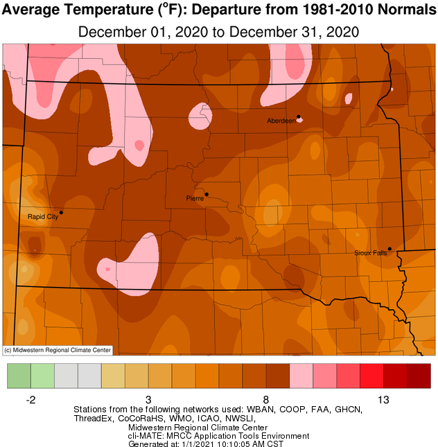
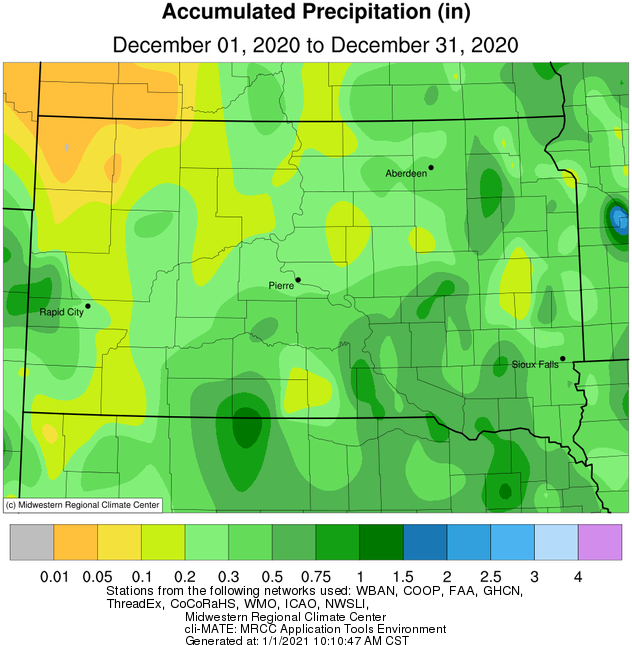
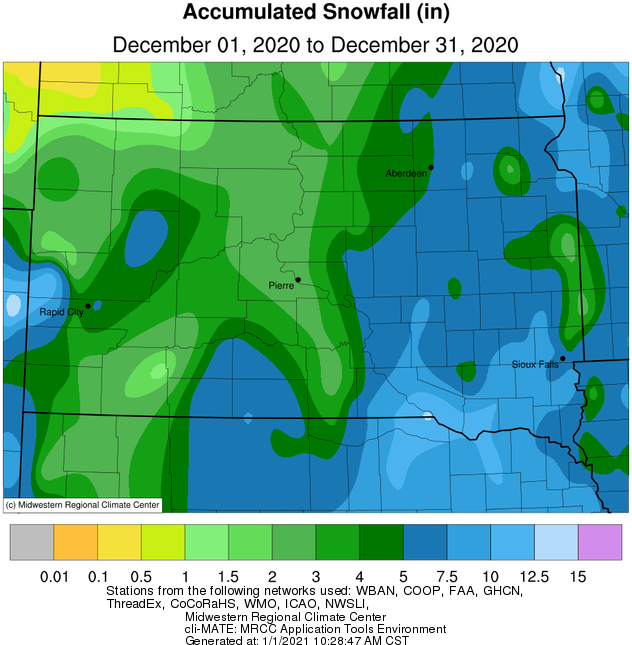
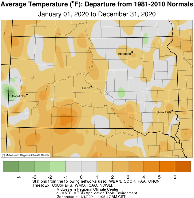
December 2020 finished very mild temperature-wise across the area, with average values ranging from 4 to 10 degrees above normal. In fact, it will go down as the 10th warmest December on record in Pierre, tied 9th in Kennebec, 7th in Timber Lake and Aberdeen, and 4th in Mobridge. Daily record high temperatures were set on a number of occasions: Dec 7th at Pierre with 58 F (58 in 1965), Dec 8th at Mobridge with 63 F (59 in 1990) and Aberdeen with 62 F (57 in 1894), and December 22nd at Aberdeen with 59 F (59 in 1893), Watertown with 55 F (47 in 1957), Sisseton with 56 F (52 in 1957) and Pierre with 68 F (59 in 1936). Kennebec warmed to 72 F on the 22nd as well, which was 2 degrees away from tying a monthly record high temperature. Just one day later, on the 23rd, a blizzard and/or high winds impacted the area, and temperatures cooled off an impressive 40 to 50 degrees. Find more information on this event here: https://www.weather.gov/abr/December23rdBlizzardReview. It had been a very dry month up until this event. While just between 1 to 4 inches of snow generally fell on the 23rd, it was enough to break a record dry streak at Timber Lake: 58 consecutive days with no measurable (at least 0.01”) precipitation (56 days ending Dec 13th in 1999). Despite another snow-producer on the 29th of 1 to 5 inches, the month finished below average for both precipitation and snow for much of the area.
|
December 2020 |
||||
|
Temperature Data |
Aberdeen |
Sisseton |
Wheaton |
Watertown |
|
Warmest Temperature / Date |
62 / 8th |
57 / 8th |
53 / 8th |
55 / 22nd |
|
Coldest Temperature / Date |
-7 / 24th |
-6 / 24th |
-8 / 24, 25th |
-7 / 24th |
|
Average High / Departure from Normal |
38.8 / +13.3 |
36.7 / +10.6 |
33.3 / +10.4 |
33.7 / +8.9 |
|
Average Low / Departure from Normal |
12.5 / +6.6 |
14.7 / +6.8 |
14.2 / +8.2 |
12.1 / +4.9 |
|
Monthly Average / Departure from Normal |
25.6 / +9.9 |
25.7 / +8.7 |
23.8 / +9.4 |
22.9 / +6.9 |
|
Precipitation Data |
|
|
|
|
|
Monthly Precipitation / Departure from Normal |
0.37 / -0.15 |
0.45 / +0.06 |
0.61 / -0.11 |
0.46 / -0.07 |
|
Most Precipitation in 24 hours / Date |
0.30 / 29th |
0.28 / 29th |
0.33 / 29th |
0.25 / 23rd |
|
Monthly Snowfall / Departure from Normal |
4.7 / -2.2 |
6.3 / -1.3 |
8.9 / +0.7 |
7.6 / +0.5 |
|
Most Snow in 24 hours / Date |
3.7 / 29th |
3.9 / 29th |
5.5 / 30th |
4.6 / 23rd |
|
Temperature Data |
Pierre |
Kennebec |
Mobridge |
Timber Lake |
|
Warmest Temperature / Date |
68 / 22nd |
72 / 22nd |
63 / 8th |
60 / 8th |
|
Coldest Temperature / Date |
4 / 14th |
-2 / 31st |
6 / 14, 18th |
4 / 14, 24th |
|
Average High / Departure from Normal |
41.5 / +10.2 |
42.9 / +10.2 |
40.4 / +11.7 |
38.3 / +8.8 |
|
Average Low / Departure from Normal |
17.5 / +5.4 |
17.2 / +5.9 |
16.2 / +8.5 |
17.0 / +7.1 |
|
Monthly Average / Departure from Normal |
29.5 / +7.8 |
30.4 / +8.4 |
28.3 / +10.1 |
28.0 / +8.3 |
|
Precipitation Data |
|
|
|
|
|
Monthly Precipitation / Departure from Normal |
0.26 / -0.29 |
0.41 / +0.03 |
0.18 / -0.26 |
0.22 / -0.26 |
|
Most Precipitation in 24 hours / Date |
0.16 / 23rd |
0.34 / 29th |
0.14 / 29th |
0.15 / 29th |
|
Monthly Snowfall / Departure from Normal |
2.5 / -2.4 |
6.0 / -0.6 |
1.9 / -3.8 |
2.4 / -5.1 |
|
Most Snow in 24 hours / Date |
1.5 / 23rd |
4.5 / 29th |
1.3 / 29th |
1.6 / 29th |
December 2020 temperature departures from normal, courtesy of the Midwestern Regional Climate Center
December 2020 precipitation totals (left) and departures from normal (right), courtesy of the Midwestern Regional Climate Center
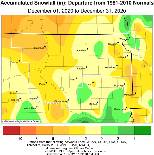
December 2020 snow totals (left) and departures from normal (right), courtesy of the Midwestern Regional Climate Center
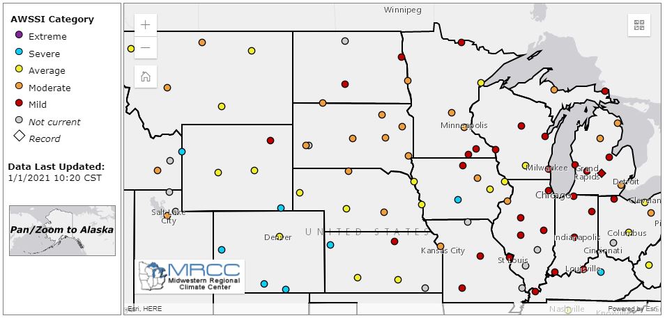
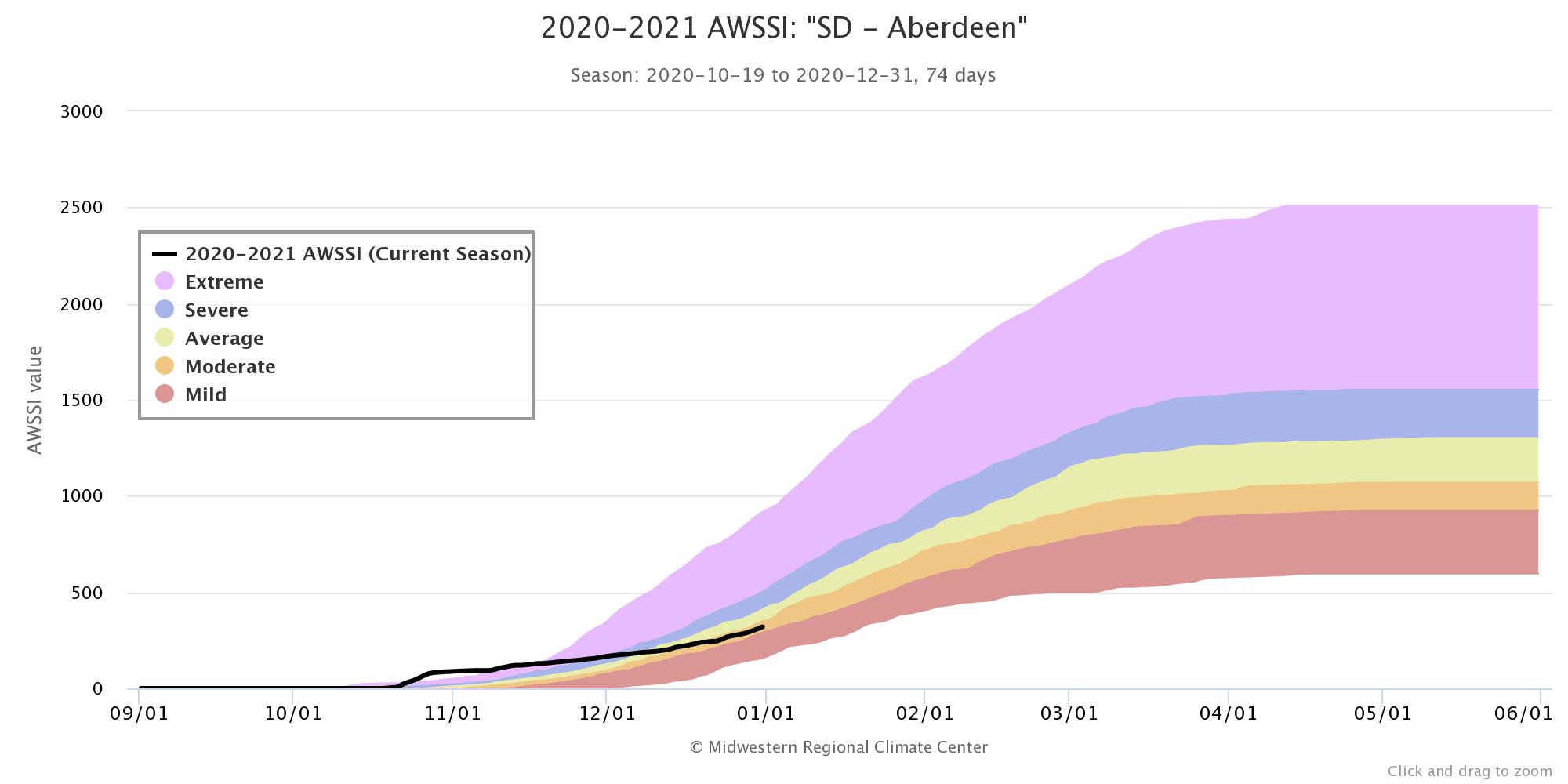
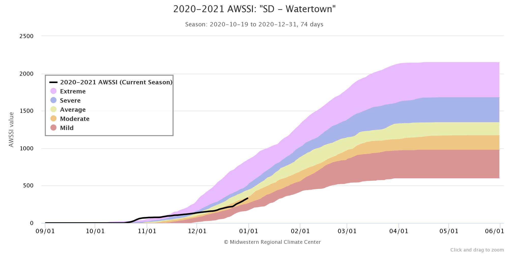
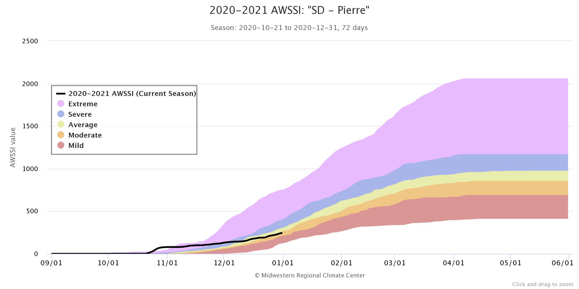
How does this winter compare to others through the end of December? The Accumulated Winter Season Severity Index (AWSSI) from the Midwestern Regional Climate Center attempts to quantify this. Below are the current rankings for Aberdeen, Watertown and Pierre (in that order). Our area is in the "Moderate" category, which falls between "Average" and "Mild."
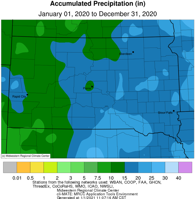
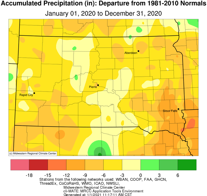
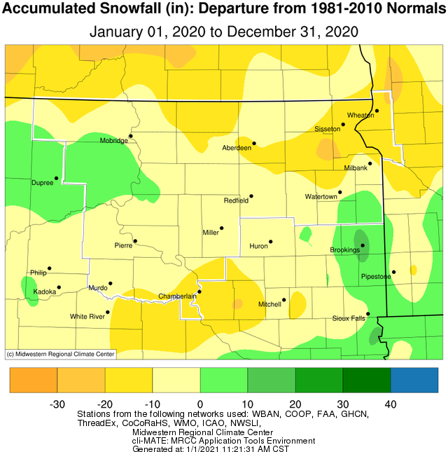
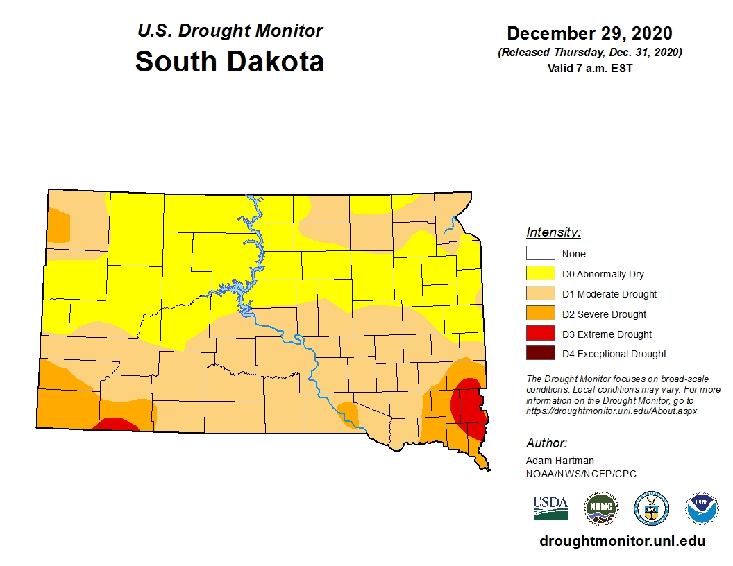
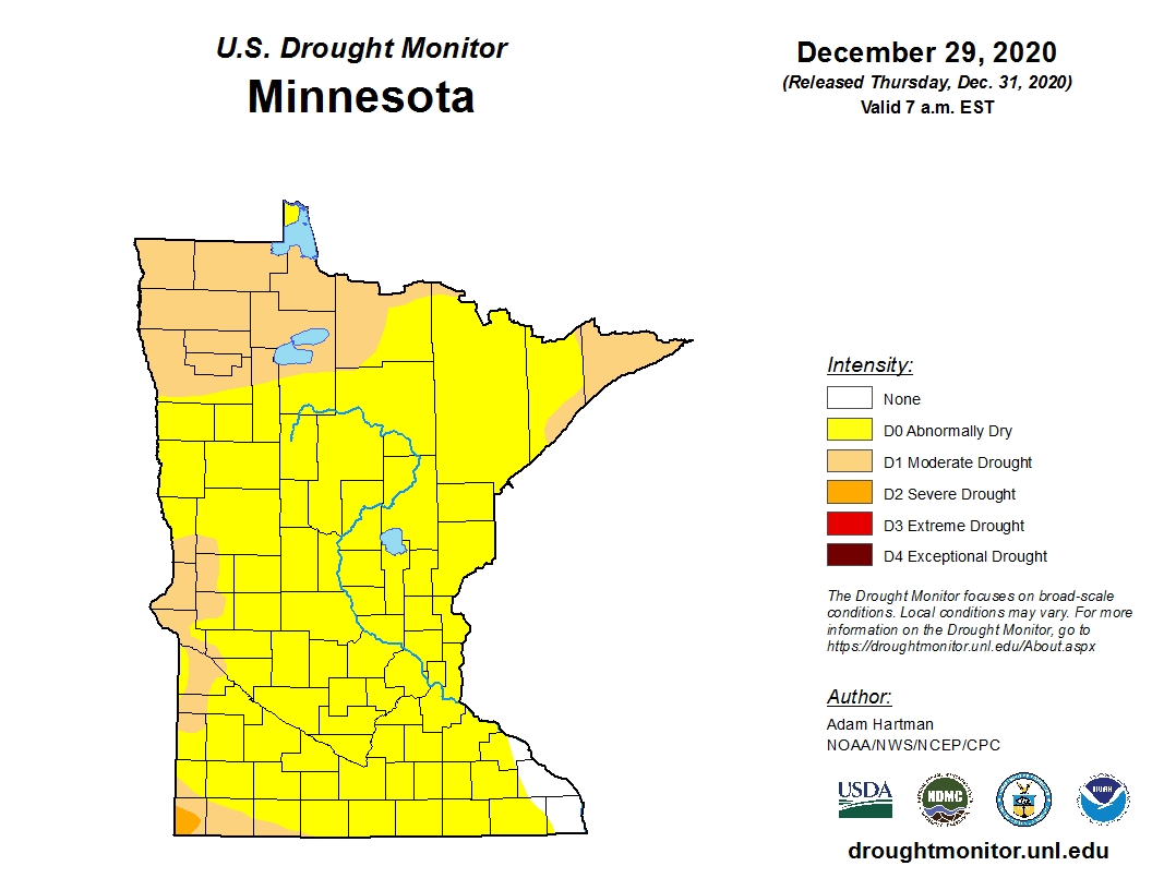
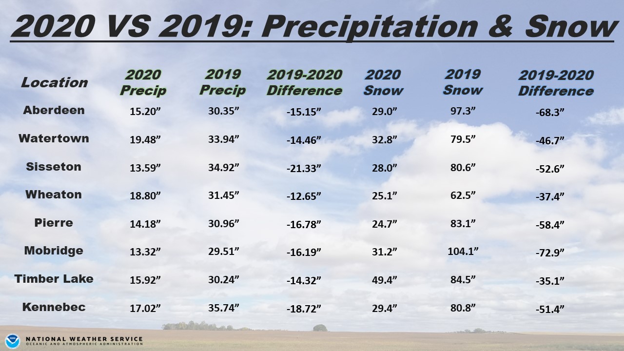
2020 finished near to slightly above average temperature-wise, and near to well below average precipitation-wise on a whole. Portions of northeastern South Dakota and west central Minnesota finished between 6 and 9 inches of moisture below normal. As of December 29th, 2020, portions of south central and northeastern South Dakota, as well as west central Minnesota were classified as being in D1/Moderate Drought by the US Drought Monitor. The rest of the area was considered Abnormally Dry. The generally dry 2020 further amplifies the difference between the in many cases record wet 2019. For example, Sisseton observed 21.33” less moisture in 2020 compared to 2019, and Mobridge had 72.9” less snow. See the graphic below for more comparisons. Even further down the page, find monthly summaries from throughout the year.
|
2020 CLIMATE REVIEW |
||||
|
Temperature Data |
Aberdeen |
Sisseton |
Wheaton |
Watertown |
|
Warmest Temperature/Date |
98 / Jun 1 |
99 / Jun 7 |
98 / Jun 7 |
93 / Jun 1,7 |
|
Coldest Temperature/Date |
-24 / Jan 16 |
-21 / Jan 11 |
-19 / Jan 16 |
-22 / Jun 16, Feb 13 |
|
Average Yearly High/Departure from Normal |
58.0 / +3.4 |
55.8 / +1.3 |
55.4 / +2.5 |
54.7 / +1.1 |
|
Average Yearly Low/Departure from Normal |
33.6 / +2.1 |
34.1 / +1.1 |
35.9 / +3.8 |
33.4 / +0.9 |
|
Yearly Average/Departure from Normal |
45.8 / +2.8 |
44.9 / +1.2 |
45.7 / +3.2 |
44.1 / +1.1 |
|
Precipitation/Wind Data |
||||
|
Yearly Precipitation / Departure from Normal |
15.20 / -6.52 |
13.59 / -8.74 |
18.80 / -6.14 |
19.48 / -2.60 |
|
Yearly Snowfall / Departure from Normal |
29.0 / -9.1 |
28.0 / -16.5 |
25.1 / -18.2 |
32.8 / -3.1 |
|
Highest Wind Gust MPH / Date |
80 / June 4 |
63 / Dec 23 |
N/A |
75 / Jul 17 |
|
Temperature Data |
Pierre |
Kennebec |
Mobridge |
Timber Lake |
|
Warmest Temperature/Date |
106 / Aug 25 |
104 / Aug 25 |
98 / Aug 22, 23, 25 |
98 / Jul 17, Aug 19, 25 |
|
Coldest Temperature/Date |
-16 / Feb 13 |
-14 / Feb 13 |
-19 / Jan 16 |
-19 / Feb 13 |
|
Average Yearly High/Departure from Normal |
61.0 / +1.8 |
62.9 / +1.8 |
59.9 / +3.1 |
58.7 / +1.4 |
|
Average Yearly Low/Departure from Normal |
35.7 / +0.1 |
36.1 / +0.7 |
34.9 / +1.8 |
34.0 / +0.4 |
|
Yearly Average/Departure from Normal |
48.3 / +0.9 |
49.5 / +1.3 |
47.4 / +2.5 |
46.4 / +0.9 |
|
Precipitation/Wind Data |
||||
|
Yearly Precipitation / Departure from Normal |
14.18 / -5.83 |
17.02 / -2.61 |
13.32 / -4.55 |
15.92 / -2.51 |
|
Yearly Snowfall / Departure from Normal |
24.7 / -7.2 |
29.4 / -7.2 |
31.2 / +0.1 |
49.4 / +9.5 |
|
Highest Wind Gust MPH / Date |
73 / Aug 27th |
N/A |
68 / Jul 31 |
N/A |
2020 average temperature values on a whole compared to normal, courtesy of the Midwestern Regional Climate Center
2020 precipitation totals (left) and departures from normal (right), courtesy of the Midwestern Regional Climate Center
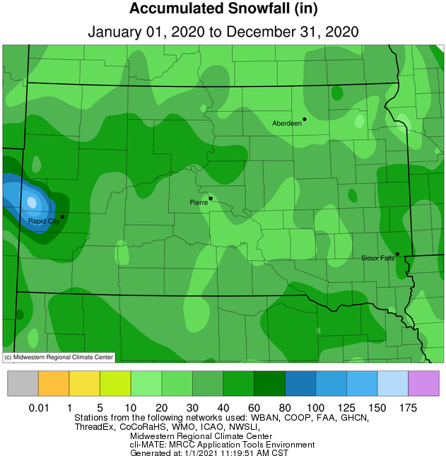
2020 snow totals (left) and departures from normal (right), courtesy of the Midwestern Regional Climate Center
US Drought Monitor as of Dec 29th
Comparison between annual precipitation and snow in 2020 VS 2019
Below is a compilation of all monthly climate summaries from 2020:
January
On a whole, January 2020 finished near normal as an average temperature-wise across the area. However, there were swings, namely, above average temperatures were in place generally in the beginning and ending thirds of the month while below average temperatures prevailed in-between. The coldest day of the month for most, January 16th, featured lows of -10 to -30 F. While warmer air moved in to end the month, it came at the cost of widespread persistent cloud cover, as well as consecutive mornings of dense freezing fog and/or freezing drizzle which resulted in slick roads and vehicle accidents.
Precipitation and snowfall for the month finished slightly above average across eastern and portions of north central South Dakota, but much of the rest of the area finished near or slightly below average. Watertown tied a daily record for snow on January 3rd, of 3.5” (2009). While no widespread heavy snow event took place across the area, enough fell on the 17th to combine with strong winds on the 17th and 18th to produce widespread blizzard conditions. For more on this event, visit https://www.weather.gov/abr/January17-182020BlizzardSummary. Localized blizzard conditions occurred on a couple additional instances across downslope wind-prone areas on the western and eastern slopes of the Coteau this month, thanks in part to a substantial snow pack and cold air. The most notable of these events occurred mostly on the morning of the 21st, when localized wind gusts of 60+ mph were recorded. A stretch of I-29 was even closed for about an hour from Sisseton to Summit due to a jackknifed semi tractor-trailer.
February
February 2020 finished near average temperature-wise; generally slightly above average across central SD and slightly below across eastern SD and west central MN. The most significant cold snap of the season occurred during the middle of the month (Pierre tied a daily record low temp of -16 F on the 13th (2007)), but there were several periods of mild weather as well. Areas with deeper snow pack, particularly following the heavy snow on Feb 8th and 9th, experienced colder temperatures on average.
Precipitation and snow-wise, south central SD, northeastern SD and west central MN finished the month below average wile portions of north central and east central SD finished slightly above average. The most widespread snow event occurred on the 8th-9th, when a relatively narrow band of heavy snow blanketed central portions of South Dakota. Visit https://www.weather.gov/abr/SummaryOfFeb8-9HeavySnowANDFeb12Blizzard for more information. The other significant event of the month took place on the 12th, when generally light snow combined with strong winds to produce blizzard conditions. See the link above for more information. That said, this February was much drier than last February, February 2019. For comparison, Watertown had 11.2” less snow, Pierre had 13.8” less snow, Aberdeen and Sisseton had 17.5” less snow, and Mobridge had a staggering 33.9” less snow.
March
March 2020 finished above average for all, up to as much as 5 degrees for some (highs and lows averaged together over the course of the month). One of the warmest days occurred early on, when Pierre set a daily record high of 79 degrees on the 7th (69 in 2006). For comparison, the all-time March high temperature in Pierre is 88 degrees, set on the 18th in 2012.
Despite a few moderate snow events across portions of Central South Dakota, the area finished well below average both in terms of snow and overall moisture. This was particularly the case across north central/northeastern South Dakota and west central Minnesota where some finished the month with more than an inch less moisture than is typical. With just 0.16” of total moisture, Aberdeen tied for their 6th driest March on record; with 0.08”, Mobridge recorded their 4th driest March; with 0.11”, Sisseton recorded their 4th driest March; and with 0.02”, Wheaton recorded their driest March on record (0.05” in 1923). Amazingly, Watertown picked up more moisture in two hours from 7pm to 9pm on April 1st (0.82”) than during all of March (0.64”). Similarly, Sisseton picked up about 10 times as much moisture in the first two days of April (0.99”) than during the whole month of March (0.11”). As for snow, the area received anywhere from 2 to 8” less snowfall than is typical. Some recorded next to no snow. With just 0.4” of total snow this March, Aberdeen received their 7th least amount on record; with a trace, Wheaton tied for 4th least; with a trace, Mobridge tied for 3rd least, and with a trace, Sisseton tied for 2nd least on record. As bad as the spring flooding has been in some areas, such a dry and warm month was a more than welcome outcome.
April
April 2020 finished anywhere from 2 to 5 degrees below normal on a whole across all of central/northeastern South Dakota and west-central Minnesota, even though the final third of the month featured days with near or above average temperatures. Sisseton set record daily cold high temperatures on the 12th (30 degrees vs 33 in 2013) and 14th (28 degrees vs 32 in 2013), as well as a record daily low temperature on the 13th (17 degrees vs 19 in 1939).
While several rounds of precipitation occurred, all areas finished the month below average except for those near the North Dakota border roughly from Eureka to Wheaton. Portions of central and east central South Dakota were driest, finishing 1 to 2 inches below average. Snowfall was generally below climatological normal for April as well. Below normal precipitation has been the trend this year, so much so that the US Drought Monitor has placed much of Central South Dakota under the “Abnormally Dry” category (one stage away from drought). Meanwhile, the James River near Columbia, Stratford and Ashton remained at either Moderate or Major Flood Stage through the entirety of April.
The most significant precipitation events included: 1.) A mix of snow (portions of northeastern and central SD picked up 2-6+”), ice pellets, freezing rain (eastern SD and west central MN) and even some lightning and thunder on Apr 1-2nd, 2.) A couple severe thunderstorms with quarter to golf ball sized hail across portions of McPherson and Edmunds to Traverse Counties on the evening of the 6th, 3.) A snow squall which impacted portions of northeastern SD on the morning of the 9th, 4.) 1-5+” of snow across south central SD on 11-12th.
May
May 2020 finished below average across the board, between 1 and 5 degrees. A particularly cold stretch occurred from the 4th through the 12th, during which time Pierre set a daily record low on the 11th of 23 degrees (25 in 1946). This happened to be just 2 degrees away from tying an all-time record low for the month of May. Additionally, a trace of snow fell at Aberdeen, Mobridge and Watertown with a system on the 9th. The last nights of widespread frost took place on the 11th and 12th, which marked the beginning of the growing season.
Precipitation-wise, central South Dakota finished slightly above average for the month, but north central and northeastern South Dakota and west central Minnesota finished below average by upwards of 1.5”. There were two main stand-out events rain-wise: The 4th and 23-24th. A slow-moving and widespread shield of steady rain impacted the area on the 4th, when daily record totals were set at Aberdeen with 2.11” (1.35” in 1905), Watertown with 0.90” (0.75” in 1912) and Pierre with 1.11” (1.04” in 1905). Unusually, Aberdeen recorded approximately 20 consecutive hours of rainfall from 7:30 am on the 4th to 3:30 am on the 5th, and Watertown approximately 22 consecutive hours from 1:00 pm on the 4th to 11:00 am on the 5th. May 23-24th featured a slow-moving complex of thunderstorms across central South Dakota when generally 1-3 inches of rain fell. As of June 1st, the James River at Stratford and Columbia continue their incredible streak of being above flood stage. Meanwhile, portions of Corson County fell into drought (D1/moderate classification) due to a continued stretch of below average precipitation.
Back-to-back Mays now, 2019 and 2020, have been incredibly quiet in terms of severe weather across NWS Aberdeen’s forecast area. The sole warning issued, a severe thunderstorm warning, was for portions of Stanley County on the 23rd. Since 1986, only two other Mays have had fewer warnings since records began in 1986: zero in 1993 and 2002. Historically, May can be a very volatile month for storms in South Dakota and west central Minnesota. A few of the most significant include the Tripp County F5 tornado on the 8th in 1965, the Spencer, SD F4 tornado on the 30th in 1998, the Bowdle EF4 tornado on the 22nd in 2010, as well as several F/EF3 tornadoes including one that began in Aberdeen on the 31st in 1996.
June
June 2020 finished well above normal across the board temperature-wise, anywhere from 2 to 7 degrees on a whole. A number of daily records were set this month including numerous record warm lows at Aberdeen, Watertown, Pierre and Sisseton ranging between 64 and 73 degrees from the 1st through the 17th, as well as a number of daily record warm highs: 95 F in Aberdeen on the 7th (95 in 1959), 94 F in Sisseton on the 1st (93 in 1940) and 99 F in Sisseton on the 7th (95 in 1959). Regarding the month as a whole, several locations recorded top-10 warm Junes on record: 9th place in Timber Lake with 70.3 F (76.7 in 1988), 7th place in Mobridge with 72.8 F (78.6 in 1911), 6th place in Wheaton with 71.6 F (75.4 in 1988), 5th place in Aberdeen with 72.5 F (79.1 in 1933) and 5th place in Sisseton with 71.7 F (75.4 in 1933).
Numerous rounds of thunderstorms across the area made for lob-sided monthly precipitation totals. Generally speaking, north central South Dakota and eastern South Dakota finished the month below average, while portions of the James Valley and portions of central South Dakota finished above average. Moderate drought conditions have remained largely unchanged from the beginning of the month to the end, with a pocket near Corson County in North Dakota and also across west central Minnesota. Meanwhile, abnormally dry conditions have expanded to include more of east central South Dakota as well as portions of central/north central South Dakota. June 2020 finished as the 4th driest on record at Timber Lake with a total of 0.76” (0.54” in 1956). Just 0.22” of moisture had been recorded up until the 28th of the month.
Thunderstorms became severe on several days this June, with the most significant and/or widespread events occurring on the 4th (https://www.weather.gov/abr/June42020SevereWinds), 6th and 7th (https://www.weather.gov/abr/June6_8_2020_SevereWx). The National Weather Service office in Aberdeen issued a total of 88 severe thunderstorm warnings across our forecast area this June, which is the second highest total since records began in 1986 (95 in 2008). An additional 4 tornado warnings were issued. A total of 42 severe/tornado warnings were issued on the 7th, which is the 3rd most on any single calendar day for our office since 1990 (the most, 44, were issued on Aug 10, 2016).
July
July 2020 finished near to up to 4 degrees above normal temperature-wise across the area. As is typical for the climatological hottest month of the year, a few heat spells with high temperatures in the 90s and dewpoints in the 70s gripped the area. Namely, July 17th and 23rd through 25th, when heat index values soared to 100-105+ degrees for many. Pierre broke the century mark air temperature-wise both on the 17th and again on the 25th as well. Rain shower-induced quick shots of hot air also resulted from heat bursts on the night of July 7th across portions of central and north central South Dakota (unfortunately also accompanied by wind gusts of 60 to 80 mph in some cases). Finally, daily record warm low temperatures were tied at Aberdeen on the 24th (76 degrees, also in 1963) and at Watertown on the 24th (75 degrees, also in 1940).
A fairly active pattern led to many precipitation opportunities, but exact location determined who finished above or below average as a whole for the month. For instance, as of July 28th, west central Minnesota and far northeastern and north central South Dakota were categorized as being in Moderate Drought (D1) by the US Drought Monitor. However, all the heat and humidity provided fuel for localized very heavy rain producers. In particular, a major flood event occurred in and around Elm Lake after 6” to as much as 11.92” (this measurement exceeds the existing state record for daily rainfall, but is still under investigation) of rain fell in under 4 hours on the evening of July 24th. More information here: https://www.weather.gov/abr/20200724_flooding. Daily record rainfall was observed at Mobridge on both the 24th (0.46” vs 0.41” in 1960) and the 31st (1.02” vs 0.88” in 1975).
Several bouts of severe weather developed this month: 15 of the 31 days involved at least one Severe Thunderstorm Warning across our forecast area. Some of the more significant events include July 4th (EF-2 tornado near Wetonka and straight-line wind gusts of 80+ mph across parts of the James Valley: https://www.weather.gov/abr/July4-52020StormSummary), July 5th (straight-line winds up to 90 mph across I-90 and funnel clouds in the Long Lake and Bowdle/Hoven areas: https://www.weather.gov/abr/July4-52020StormSummary), July 6th (straight-line winds of 80+ mph across Jones/Lyman counties), July 17th (thunderstorm outflow wind gusts up to 80 mph across northeastern SD and west central MN), and on July 31st (thunderstorm outflow wind gusts up to 80 mph mainly across central SD). July 17th featured a Storm Prediction Center-issued Particularly Dangerous Situation (PDS) Severe Thunderstorm Watch which included Corson to Big Stone/Traverse Counties. PDS Severe Thunderstorm Watches are rare (issued on average only a few times a year across the country) and are designated for high-end wind threats with the potential for widespread and significant damage. The last time our forecast area was under such a watch was on June 19th, 2015 (Stanley/Jones to Buffalo Counties).
August
August 2020 finished near to as much as four degrees above average on a whole across the area. An extended period of near to above average temperatures took place from the middle of the month until around the 27th. Of note, Pierre reached 90 degrees 17 times this August (above average) compared to just one time last August (record fewest). Pierre’s warmest temperature this August was 106 F on the 25th, which was the warmest day since July 9th, 2017 (also 106 F).
Precipitation-wise, the area ranged quite a bit from pockets of up to 2” above average to pockets of up to 1.5” below average. Abnormally dry to drought conditions persisted or slightly worsened through the month for many, due to the generally spotty nature of precipitation. Thanks in part to the drier than average weather, the James River at Columbia finally fell below flood stage on August 30th, after 518 consecutive days of being in flood stage (began March 31st, 2019).
Two significant severe weather events took place late in the month. The first involved an overnight line of thunderstorms from the 27th-28th, responsible for 100+ mph wind gusts as well as tornadoes across central into east central South Dakota (https://www.weather.gov/abr/SummaryOfTheAugust26-282020SevereWeather). The second involved a significant tornado in Hand County on August 30th (https://www.weather.gov/abr/August30_2020_Tornado). Tragically, this tornado resulted in South Dakota’s first tornado fatality since June 4th, 1999 in then Shannon/now Oglala Lakota County.
September
September 2020 finished close to average temperature-wise on a whole across the area. That said, there were some large temperature swings. Namely, a record cold stretch from the 7th through the 11th and a much above average stretch from the 20th through the 26th. Very little in the way of precipitation fell, with all locations recording between 0 and 3 inches of below average rainfall, and abnormally dry and/or moderate drought conditions persisted as a result. Thanks to the dry conditions, the James River at Stratford finally fell below flood stage during the early morning of the 30th, after a record 546 consecutive days which began on April 3rd, 2019. Several windy days with gusts of 40-60 mph occurred towards the end of the month, which raised fire weather concerns. Smoke from significant California fires drifted aloft across the Northern Plains for many days this September as well, thanks to upper-level winds. There were a couple days where enough smoke made it to the surface to reduce visibility below 6 miles for some, including on the 20th at Aberdeen and Watertown. Also of note this September, no reports of severe weather were logged. This was the first time since 2011 where our weather forecast office didn’t issue a single convective warning (severe thunderstorm or tornado), and only the 4th time since 1986.
October
While beginning rather mild, October 2020 will be remembered for its cold and snow thanks to a record-laden period from the 19th through the 28th (the first snowfall for many occurred from the 16th through 18th, but was light). Three separate storm systems combined to blanket the area under several inches of snow (as well as some ice across portions of central SD), and this anomalous snow pack helped to manifest very cold temperatures when compared to normal. On a whole, this was the 8th coldest October on record in Aberdeen and Kennebec, 7th coldest in Watertown, 6th in Wheaton, 5th in Pierre, Mobridge and Timber Lake, and 3rd Sisseton. In terms of a single day, when averaging the high and low together, Pierre and Sisseton observed their coldest October day on record on the 26th. Also on the 26th, Pierre and Mobridge observed their coldest October temperature on record. Regarding total October snowfall, this was the 6th snowiest on record in Watertown, 4th in Kennebec, 3rd in Pierre, 2nd in Aberdeen, and 1st at Mobridge, Sisseton, Wheaton and Timber Lake. Additional information regarding the numerous daily and monthly cold and snow records, and more, can be found here: https://weather.gov/abr/2020MidOctoberSnowstorms. Also of note, area lakes and rivers were unfrozen during this time, and lake effect clouds/snow developed across portions of the Missouri River and in and around the Coteau between the 25-27th, as well as other times. Despite the abundant snow, total precipitation for the month finished below normal, generally by between 0.1 and 1.0 inches, and all counties in our forecast area were classified as either D1 Moderate Drought or D0 Abnormally Dry by the US Drought Monitor as of Oct 27th. The vast majority of the snow had melted by the end of the day on the 31st.
November
The whole region observed much above average temperatures on a whole this November, of generally between 6 to 9 degrees. A plethora of record-setting warm days early on, in particular, resulted in the 5th warmest first week of November on record in Aberdeen, 4th at Watertown, Mobridge and Sisseton, and 3rd at Pierre. See the graphic further down the page for a listing of records through the first week of November at our Automated Surface Observation Station (ASOS) sites, including a couple monthly records. Additional warm temperature records set throughout the month not in that graphic include a tied monthly record of 81 F in Wheaton on the 5th (Nov 1st in 1950), a daily record of 60 F at ABR on 28th (59 in 1949), 59 F at 8D3 on the 28th (55 in 1949), a record warm low of 36 F at PIR on 18th (36 in 2019), record warm low of 44 F at ATY on the 8th (43 in 2006), and a record warm low of 35 F at MBG on 18th (34 in 1976). On a whole, the month finished as the 10th warmest on record in Mobridge, 8th warmest November on record in Kennebec, and tied 4th at Wheaton.
With just a trace or less of moisture/snowfall, November 2020 will go down as one of the driest on record for several locations across Central South Dakota. Specifically, just a trace of moisture fell over the 30 day period at Timber Lake and Mobridge, and just a trace of snow was observed at Wheaton and Mobridge. Timber Lake tied their least snowy November on record with zero snow. This, on the heels of a record-setting snowy October. As a result of the dry pattern, D1/Moderate Drought expanded to include much of the southern half of South Dakota by the end of the month, while remaining largely unchanged across portions of northeastern South Dakota and west central Minnesota. Far northeastern/eastern South Dakota and west central Minnesota did observe a more typical November in terms of precipitation, though snowfall was still below normal. Those in and around Deuel County picked up the most snow, as a couple systems with multiple inches of snow clipped that area. A daily snowfall record of 2.4” was set at Aberdeen on the 9th (2.0 in 1982) as well.
December
December 2020 finished very mild temperature-wise across the area, with average values ranging from 4 to 10 degrees above normal. In fact, it will go down as the 10th warmest December on record in Pierre, tied 9th in Kennebec, 7th in Timber Lake and Aberdeen, and 4th in Mobridge. Daily record high temperatures were set on a number of occasions: Dec 7th at Pierre with 58 F (58 in 1965), Dec 8th at Mobridge with 63 F (59 in 1990) and Aberdeen with 62 F (57 in 1894), and December 22nd at Aberdeen with 59 F (59 in 1893), Watertown with 55 F (47 in 1957), Sisseton with 56 F (52 in 1957) and Pierre with 68 F (59 in 1936). Kennebec warmed to 72 F on the 22nd as well, which was 2 degrees away from tying a monthly record high temperature. Just one day later, on the 23rd, a blizzard and/or high winds impacted the area, and temperatures cooled off an impressive 40 to 50 degrees. Find more information on this event here: https://www.weather.gov/abr/December23rdBlizzardReview. It had been a very dry month up until this event. While just between 1 to 4 inches of snow generally fell on the 23rd, it was enough to break a record dry streak at Timber Lake: 58 consecutive days with no measurable (at least 0.01”) precipitation (56 days ending Dec 13th in 1999). Despite another snow-producer on the 29th of 1 to 5 inches, the month finished below average for both precipitation and snow for much of the area.

